The week ahead will be generally quiet across Colorado’s Front Range with large scale ridging in place and the window for monsoon moisture quickly waning. Read on to find out which day we think offers the best chance of rain.
We also provide thoughts on the recent landfall of Category 4 Hurricane Harvey in Texas.
Hurricane Harvey
When we saw Harvey beginning to take shape last Thursday in the Gulf of Mexico….with nothing but 85 to 90 degree waters in its path, we had a very bad feeling Texas would be in trouble. Sure enough, the storm explosively intensified into a Category 4 monster before making landfall near Rockport, TX last Friday evening with winds of 140 mph.
Here is a closer look at the impressive eye as it came ashore last Friday evening.
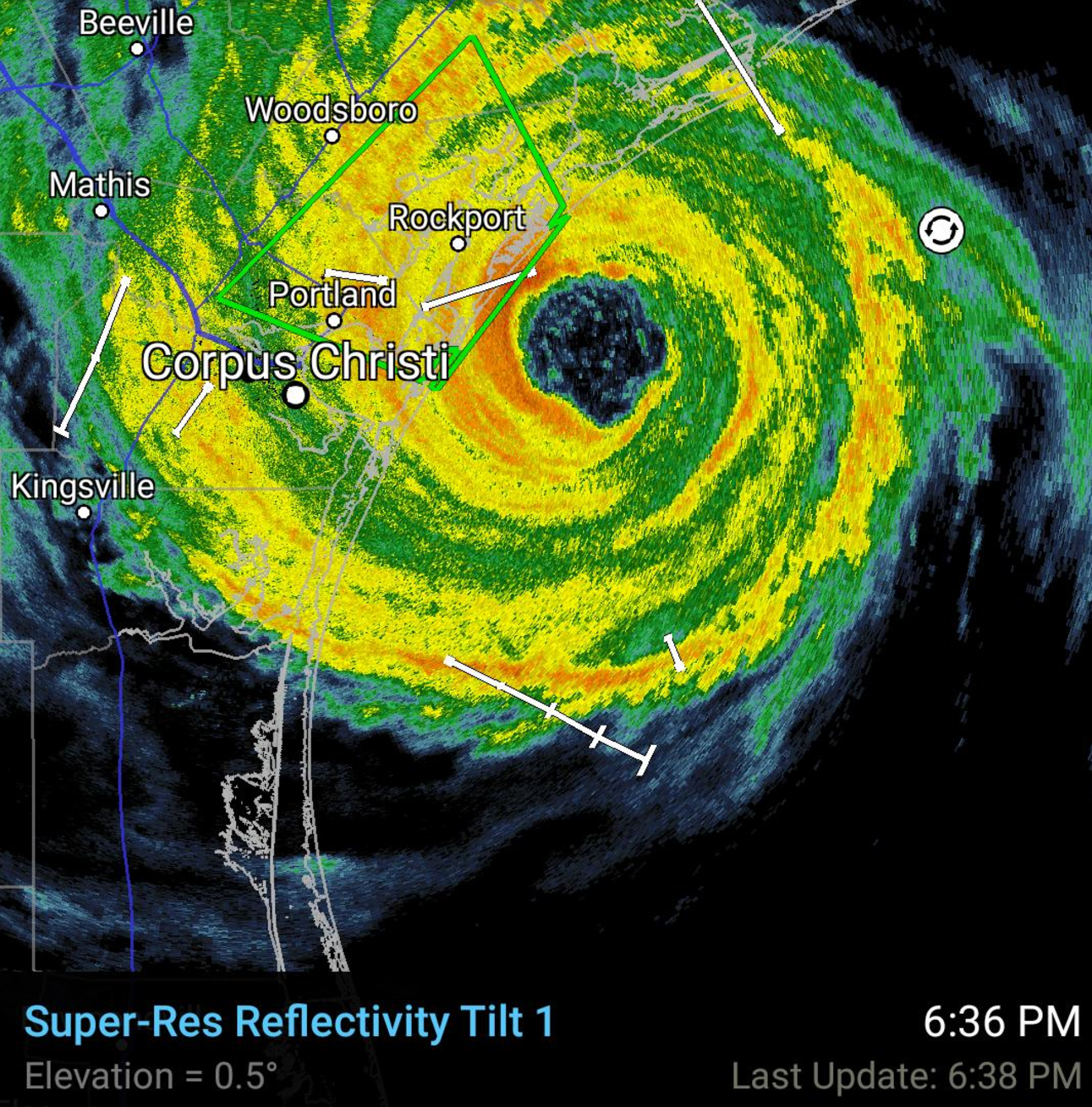
High-resolution radar image of Harvey just before making landfall in Texas last Friday | RadarScope
Following the initial blast of 140 mph winds as the eye wall rammed into the Texas coast, the storm has barely moved over the weekend. The center has tracked only about 100 miles over the last 60 hours, equating to an average movement speed of less than 2 mph!
Staggering rainfall totals have been reported in southeast Texas which has lead to devastating flooding in many communities. Ten or more inches of rain has fallen so far region-wide, with the hardest hit locations seeing more than 35 inches!
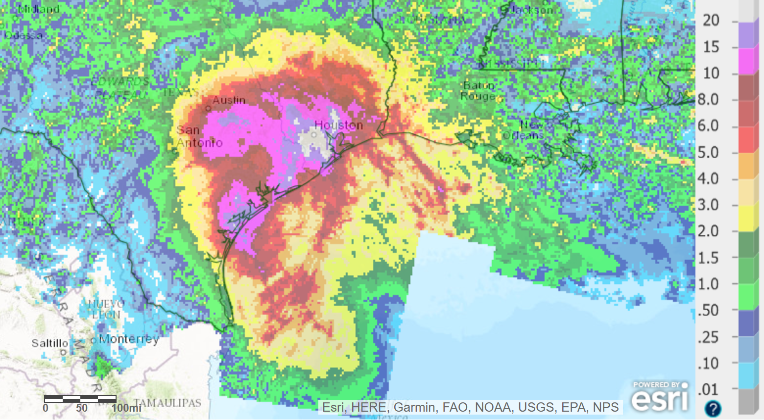
Radar estimated total accumulated precipitation from Hurricane Harvey thus far | NOAA
One weather observer south of Houston reported 9.92″ of rainfall in 90 minutes, and nearly 7″ of rainfall in one hour. The radar estimates nearby agree with this observation, too (shown below). Could you imagine more than 50% of Boulder’s annual precipitation falling in an hour?
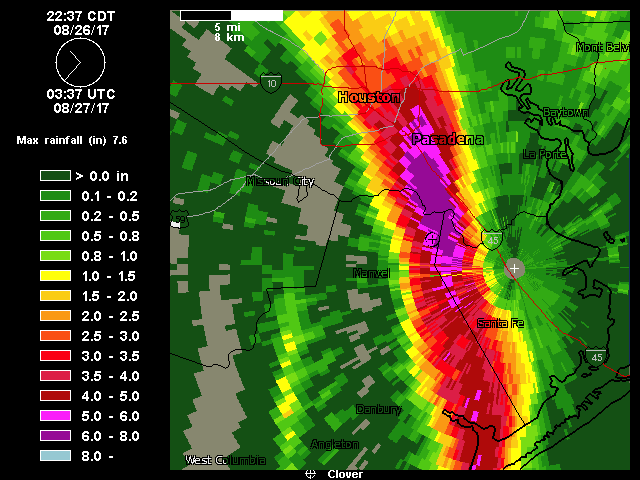
Doppler estimated rainfall rates in an outer band of Harvey Friday night. Greater than 7″ per hour!
Flooding of this magnitude associated with a tropical system last occurred in 2015 alongside Hurricane Joaquin in South Carolina.
The reason for Harvey’s slow movement is the prevailing weather pattern currently in place across the United States. A large dome of high pressure centered across Utah is preventing the storm from tracking inland. At the same time, a weaker ridge extending eastward from Florida and across the Gulf of Mexico is not allowing Harvey to exit eastward.
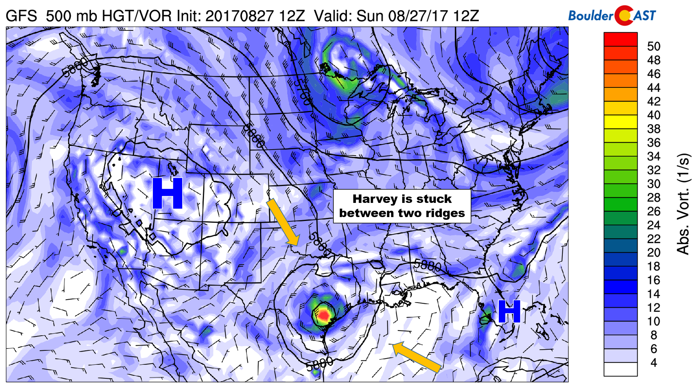
GFS vorticity map for yesterday (Sunday) showing the factors contributing to the stalling of Harvey
The end result is a near-stationary and very organized tropical system with easy access to nearby warm ocean water. Though, the impact of the eye moving over the land has greatly reduced the storm’s strength (as of Monday morning, it remains a tropical storm). The only saving grace is that the hurricane didn’t stall 100 miles further south over open water. That would have been truly legendary.
Scientists will likely draw many similarities between Harvey and Katrina which made landfall in Louisiana twelve years ago, and for good reason. Intensification from a few spinning clouds to a major Hurricane in just over 36 hours is not something our coastal cities can easily prepare for. With sporadic pockets of super-heated ocean waters in the Gulf of Mexico becoming more common, these type of scenarios will occur more frequently.
Quiet week ahead in Colorado
Thanks to that same ridge impacting Harvey across the western United States, our weather will be relatively quiet for the week ahead.
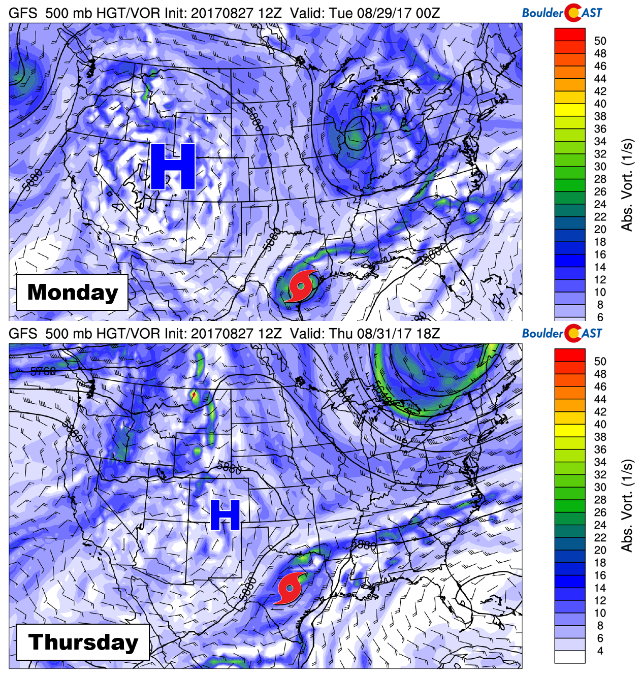
Dry northwest flow will keep precipitable water values below season normals (less than 0.5″) at least through Tuesday. After this point, models are showing a few weak waves moving across the state along with very slight increases in moisture…not impressive by any means and rain chances will still remain sparse. The chance of rain is virtually zero today, and there will be only a slight uptick in rain chances Tuesday through Thursday, particularly for the higher elevations. Thursday will likely offer our best chances of rain as a wave passes across Colorado in the northwest flow. Even then, we’re only talking 20-30% chances at this point.
Though the week, temperatures will be slightly warmer than normal with highs in the mid 80’s to lower 90’s. And with the northerly component to our mid-level winds, Canadian wildfire smoke will likely be present this week in the Metro area.
By Friday, drier air is expected to regain its hold on Colorado. It appears that the holiday weekend will be quiet statewide, with limited if any chances of storms in the Mountains and temperatures near or slightly above normal.
Monsoon update
We discussed with our Premium subscribers last week the lull in the monsoon as observed from the Tucson dew point tracker and the observed recent rainfall at BoulderCAST Station (see below).
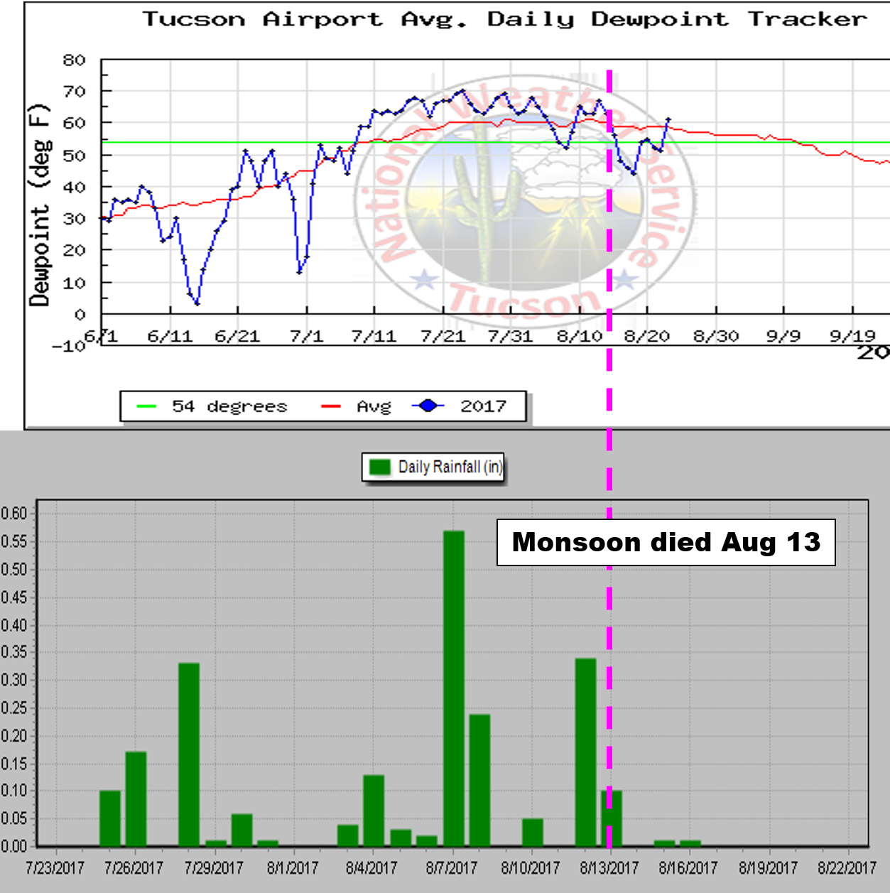
It looks as those our monsoon season may have come to an end as of August 13th. Long-range model guidance suggests a large ridge rebuilding across much of the western United States late this week or early next. This will bring warm conditions to the Front Range and likely make regular afternoon thunderstorms a thing of the past.
Enjoy a storm this week if you can!
Forecast Specifics:
Monday: Abundant sunshine with just a few afternoon clouds here and there. Extremely isolated storms across the higher elevations will be possible by early evening. Highs will climb into the upper 80’s on the Plains, with upper 70’s in the Foothills.
Tuesday: Morning sunshine with partly cloudy skies taking over after lunch. Expect isolated thunderstorms to form during the late afternoon and evening. Highs in the low 90’s across the Plains, with low 80’s in the Foothills.
Wednesday: Morning sunshine with increasing afternoon clouds. A progressive wave should fire off scattered storms in the Mountains, with isolated storms across the Plains. Temperatures still warm in the low 90’s across the Plains and near 80 in the Foothills.
Thursday: Partly cloudy early, with mostly cloudy skies taking over after noon. Expect widely scattered afternoon and evening storms across the Plains and Mountains. This is probably our day with the best chance of rain. Expect highs to be cooler in the low to middle 80’s on the Plains and low 70’s in the Foothills.
Friday: Mostly sunny with very isolated afternoon and evening thundershowers. Highs will likely be in the mid to upper 80’s for the Plains, with mid 70’s in the Foothills.
Labor Day Weekend: The upcoming holiday weekend looks excellent for outdoor activities statewide. With a ridge remaining in place to our west and dry air in general, Colorado will be mostly rain-free with above normal temperatures through the weekend! The only exception looks to be a slight chance of afternoon storms in extreme southern Colorado.
High Country: Overall we’re expecting a fairly quiet week in the higher elevations. While we can’t rule out storms any day, chances will be slim Monday, Tuesday and Friday (isolated storms), with slightly higher odds Wednesday and Thursday (widely scattered storms). Temperatures will be above normal for late August. Winds will generally be less than 15 mph across the higher peaks from the north or northwest through the week. Find the best days to hit the mountains over at our SummitCAST page. The first 2 days are always free. Upgrade to BoulderCAST Premium to unlock all 6 days.
DISCLAIMER: This weekly outlook forecast is created late Sunday or Monday morning and covers the entire upcoming work-week. Accuracy will decrease as the week progresses as this post is NOT updated. To receive daily updated forecasts, subscribe to BoulderCAST Premium.
Share our forecast:
Mon
Tue
Wed
Thu
Fri


Temperature
88
91
91
84
87


Precip Chc (Plains)
0%
10%(pm)
20%(pm)
30%(pm)
10%(pm)


You must be logged in to post a comment.