7th Annual BoulderCAST First Snowfall Contest
*Contest is now closed to entries*
Are you eager for the first snow of the season? Have you already waxed your skis and purchased your Epic Pass? Our first big snow could be right around the corner! Mother Nature threw us a giant curve-ball last year with our earliest accumulating snowfall on record in Boulder and 2nd earliest in Denver on September 8, 2020, but what’s in store for 2021? We provide a brief overview of Boulder’s first snowfall climatology, discuss the snowfall forecast for coming weeks and months, and then pose a question…“When will Boulder’s first measurable snow occur this year?” Submit your guess for a chance to win an assortment of prizes. Those who get closest to the date of our first snow win..
First snows of Boulder’s past
September weather is often a bit of a “mix bag” in the Denver Metro area. The first snow of the year can and often does occur during the month, but we’ve also seen historic flooding and lengthy heat waves. We’ve already gotten a taste of this variability with last year’s historic early snow. One year later, this week there is no sign of snow and we’re talking about record heat in the middle 90’s. Hard to believe, right? This is the nature of the business during the transitional months in Colorado. Let’s briefly review some statistics of Boulder’s annual first snowfall. Hopefully this will give you some context for your contest entry to follow.
The chart below shows the date of Boulder’s first measurable snowfall for each year dating back to 1948. Measurable means that officially 0.1″ or more of snow was recorded. As is often the case early in the snow season, a few flakes mix in with rain, or flurries briefly fly, but never stick to the ground. These are instances where a trace of snow has occurred, but wasn’t measurable. For the purposes of the contest, we don’t care about these non-measurable snowflakes. We want accumulation!
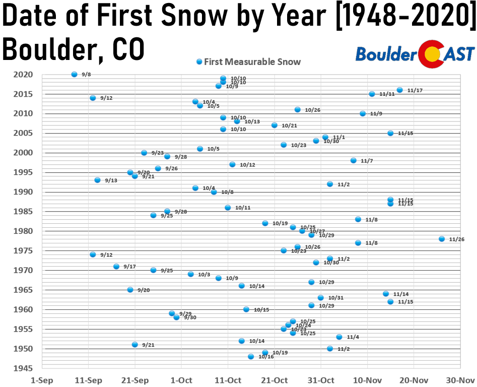
You can see there is a huge variation from year-to-year in the date of our first measurable snowfall. The earliest was September 8, 2020, with 1.7″ of snow falling. The latest measurable snow was November 26, 1978. That’s a spread of nearly three months! The normal (median) date of our first snow is October 17th.
How about a few percentiles for the gamblers out there? The odds of our first measurable snowfall occurring on or before…
- September 20th: 10%
- October 1st: 25%
- October 17th: 50%
- October 31st: 75%
- November 10th: 90%
These numbers work out nicely and equate to our first measurable snowfall occurring in September 25% of the time, in October 50% of the time, and in November 25% of the time.
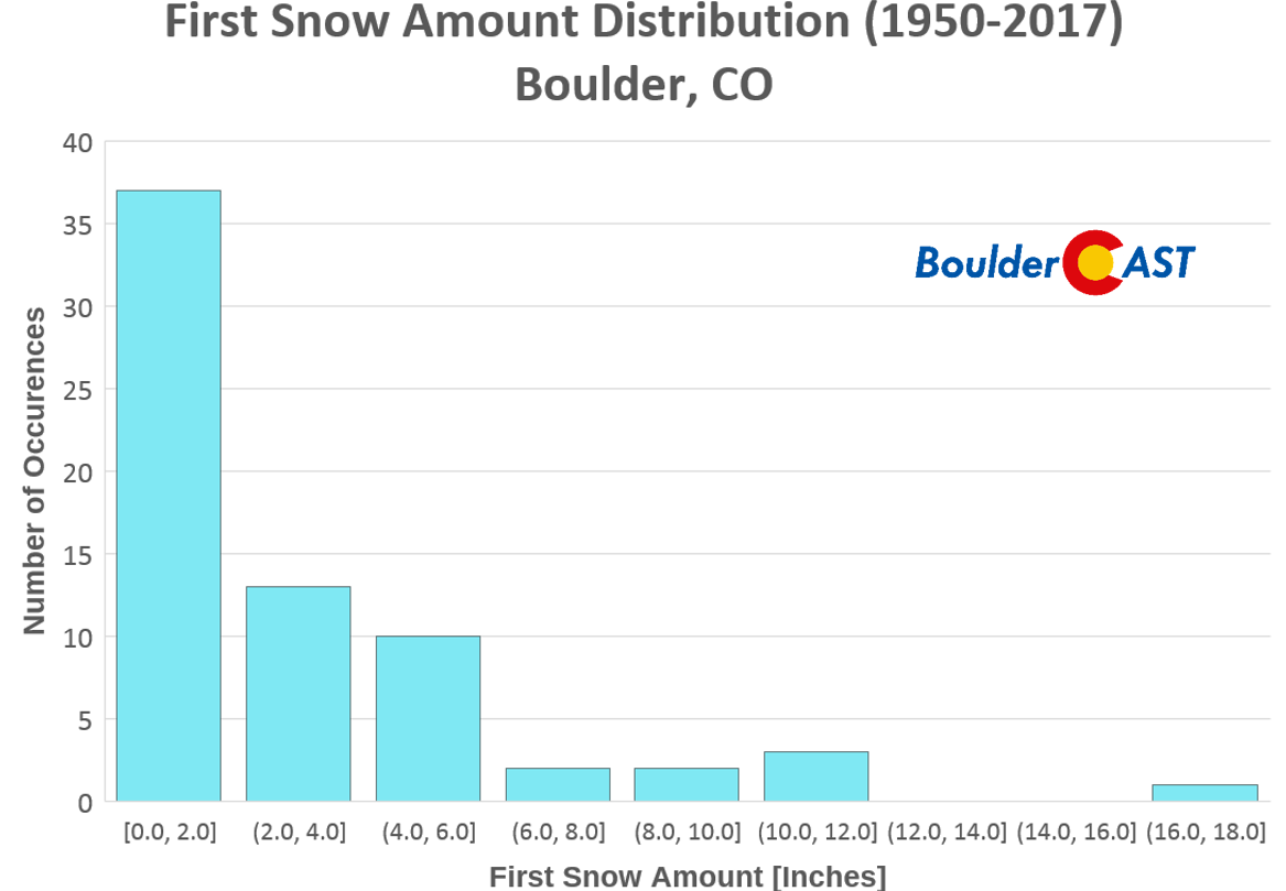
As you might imagine, our first snow event each year is usually a small amount…providing only an introductory taste of winter. The histogram below shows that 37 years since 1950 had an inaugural snowfall less than 2.0″ (54% of the time). Boulder’s first snow only exceeded 6.0″ on 8 occasions (12% of the time). The average amount of Boulder’s first snow is 3.0″, while the median amount is 2.0″.
Snowfall outlook for the start of Autumn
With that brief history lesson complete, let’s discuss the possibility of snow in the near-term.
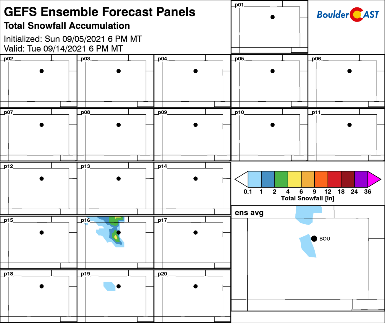
This time of year, so early in the season, just about the only way snow can happen on the Front Range Plains is if an epic trough develops across the western United States, spawning a cut-off system that funnels extremely cold air southward east of the Rockies along with some upslope. Taking a look at the last several runs of the GFS and the European models, as well as their ensembles, we’re not seeing much that suggests snow is headed to Boulder through at least the end of next week (Sept 17th). There are a handful of ensemble members showing a little snow in Colorado next week, but that’s only for the highest Mountains.
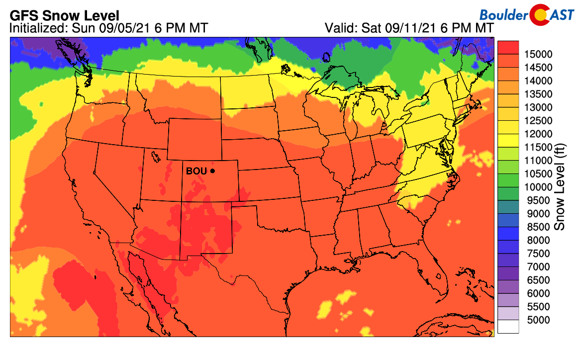
While the wave-train will remain somewhat active across the Pacific Northwest and the far northern Rockies, it doesn’t look like Colorado will get much moisture and definitely not enough cold air for snow anytime soon in Boulder. The Mountains will see little in the way of snow as well even as the pattern becomes slightly more active during the weekend of the 11th. It will be just too warm with snow levels largely remaining above 14000 feet.
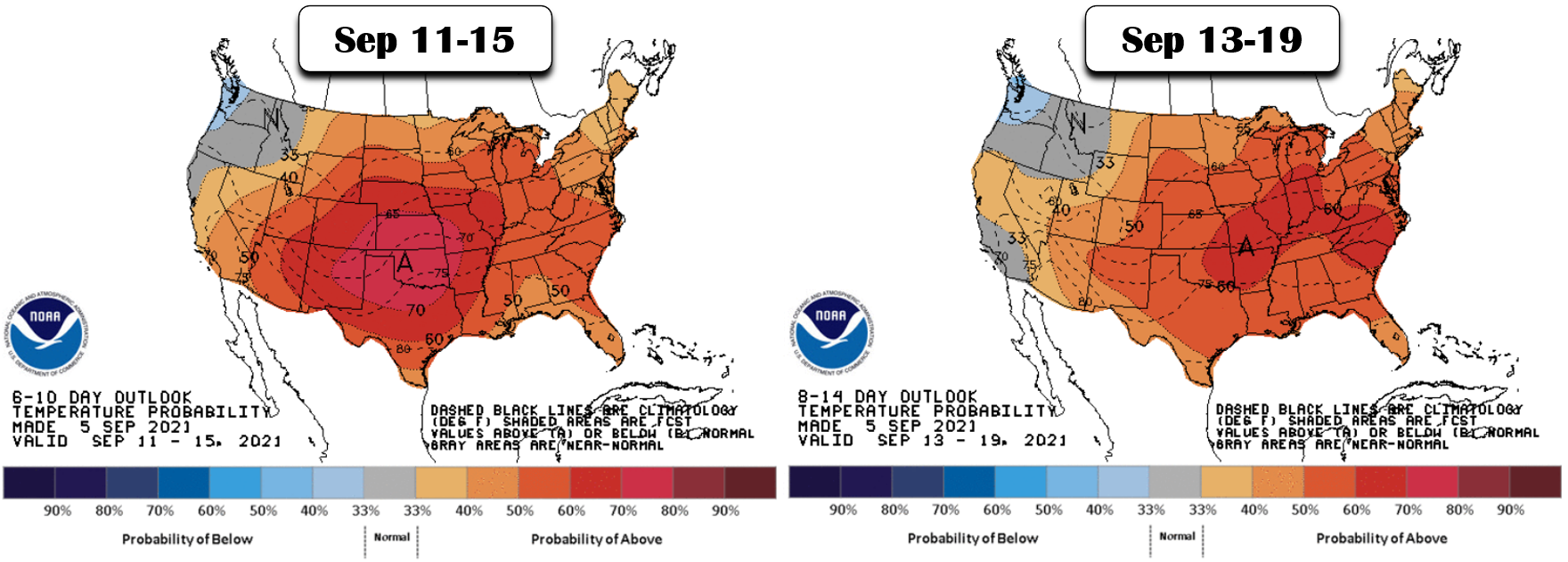
The Front Range is poised to remain mostly dry with temperatures above normal in the near-term. While there is a slight chance of showers a few days here and there this weekend into next week, chances overall will be rather low. And certainty anything that falls across the Boulder area will be rain during this time with temperatures peaking in the 80’s and 90’s. As you can see below, the CPC is projecting a very high chance of above normal temperatures for the next two weeks in Colorado and much of the United States in fact.
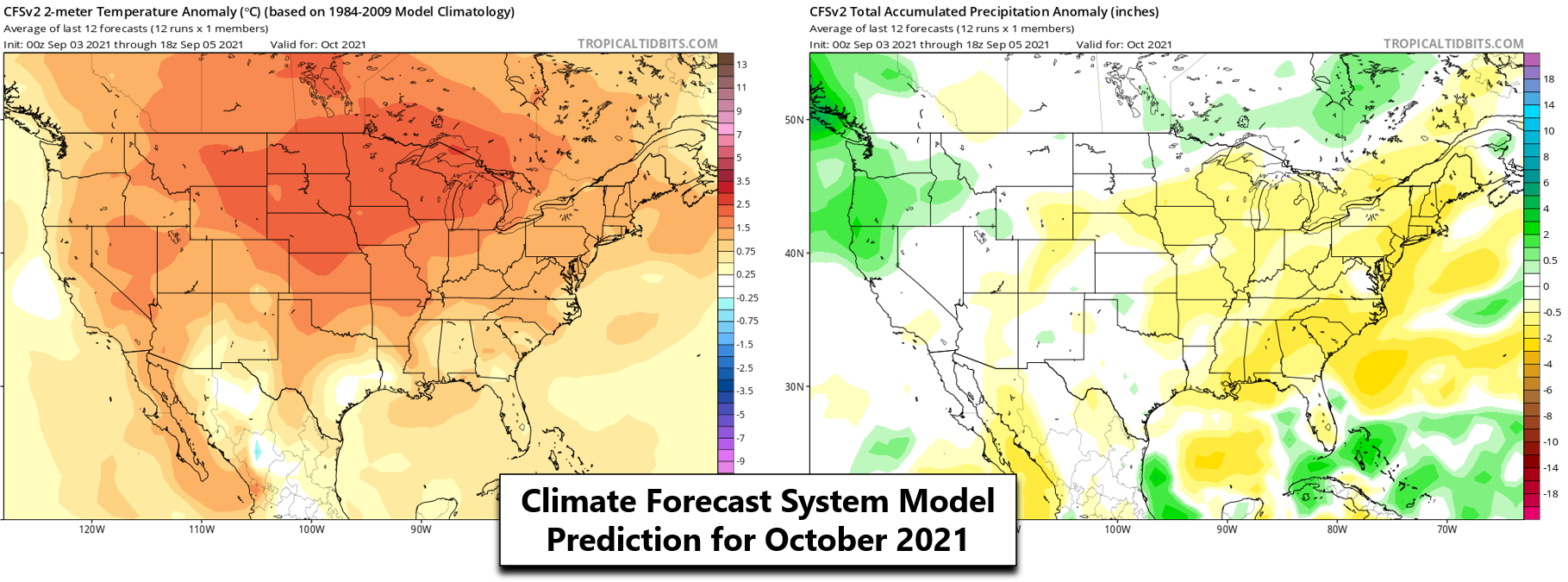
Looking further down the road, almost all indication from long-range weather and climate model guidance has the next 15 to 90 days being warmer than normal overall across Colorado, too. Of course, this doesn’t mean there won’t be some cooler stretches here and there, but odds are favoring warmer conditions with less chances for snow during October and through much of Autumn 2021.
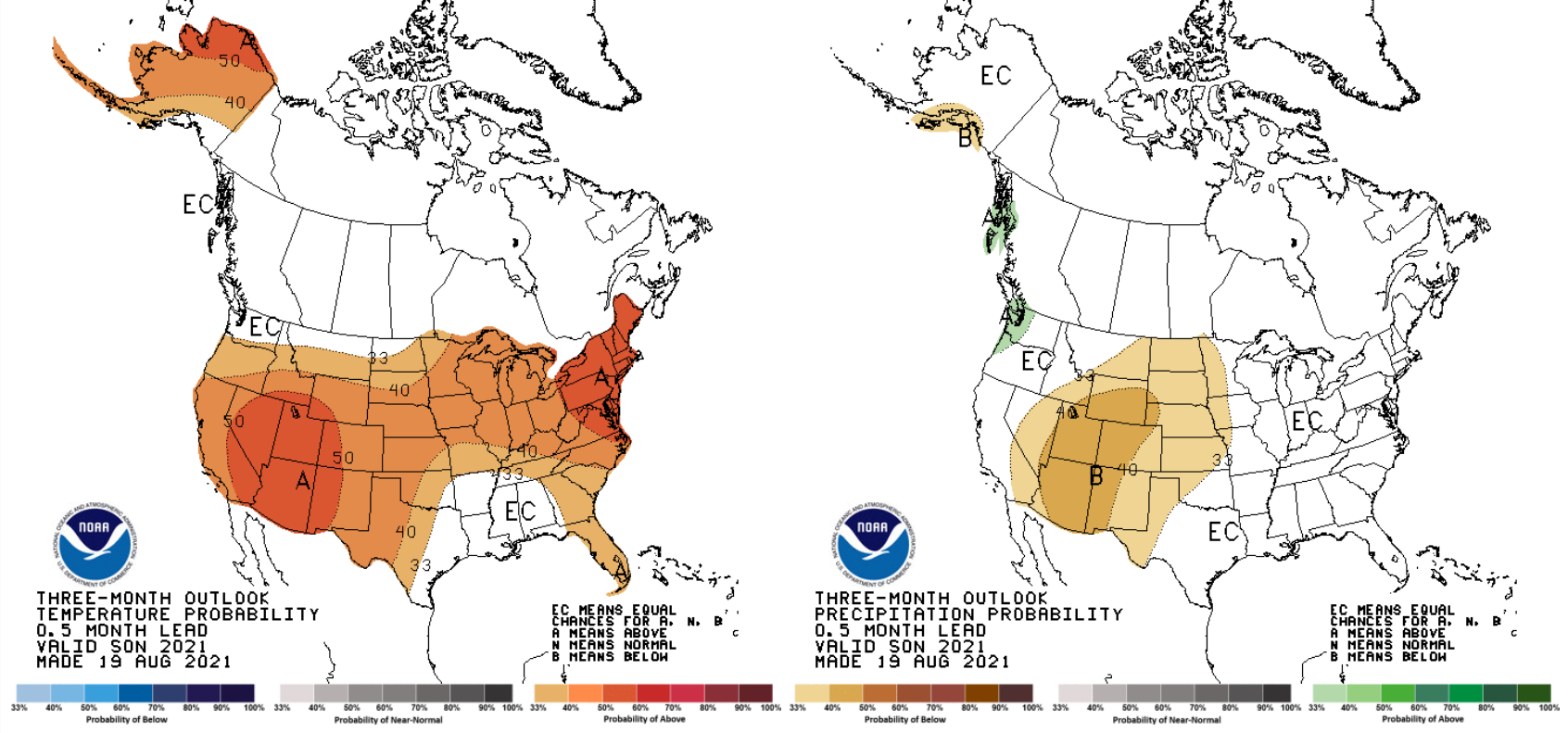
Sept-Oct-Nov 2021 temperature (left) and precipitation (right) outlook from the NOAA Climate Prediction Center
While it only takes one brief shot of unseasonably cold air to give us our first snow of the season, it seems more likely that Boulder’s first snow event may come LATER rather than sooner this year…
Enter our 2021 First Snow Contest!
Without further adieu, let’s move on to the contest! This is a community poll for the date you think the first MEASURABLE snowfall will occur in Boulder. Those who come closest to the actual date are the winners. For verification, we’ll go off the official Boulder climate station located at the NIST building in south Boulder (FYI, they follow UTC time for date cut-offs).
For prizes, we’re giving away BoulderCAST Premium subscriptions and Amazon Gift Cards.
Among many perks, Premium members get full-access to our daily forecast discussion every morning. This is especially useful in the winter, when our meteorologists brain-dump thoughts for days leading up to impactful snowstorms. In case you weren’t with us over the last five winters, we tend to do very well for the entire Denver Metro area (2015-16 Recap / 2016-17 Recap / 2017-2018 Recap / 2018-2019 Recap / 2019-2020 Recap). Premium members also have admittance to our full suite of weather model graphics, complete 6-day hiking and 6-day ski forecasts, have exclusive access to select content such as video forecasts and weather quizzes.
The prizes for the contest are as follows:
- 1st place: 12-month Premium subscription + $30 Amazon Gift Card
- 2nd place: 6-month Premium subscription + $10 Amazon Gift Card
- Anyone who guesses within 1 day OR 0.1″ correct: 2-month Premium subscription
- All other entries: Virtual “pat on the back”
IMPORTANT: In the event that multiple participants select the same date, the tie-breaker of snowfall amount will be used.
To get things started, here are the dates that some of the BoulderCAST Team has placed their bets on for our first snow:
- Ben: October 14th – 2.2″
- Andrew: October 10th – 2.0″
- Keah: October 31st – 3.9″
- Matt: October 18th – 5.0″
Enter you NAME, EMAIL, and guesses for DATE and AMOUNT in the form below on or before Monday September 20, 2021. Please only one entry per person.
*Contest is now closed to entries*
Prizes and recognition will be awarded in the days following our first dumping of snow. Let’s hope it’s a big one!
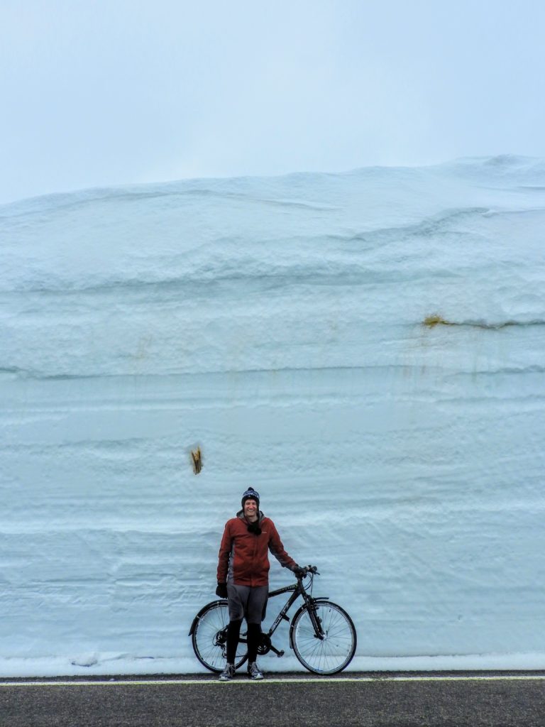
Photo taken along Trail Ridge Road in Rocky Mountain National Park, May 2019
.
Help us reach more people before winter! Share this contest with your friends:
.



You must be logged in to post a comment.