
Seasonal change is ongoing across Colorado as of early Monday morning with a blustery Pacific storm system plowing across the state. Snow is falling in the Mountains with some rain across the Denver area, too. This storm system will usher in much cooler temperatures to start the week. However, warmer weather will return by Wednesday (the first official day of fall!) and continue into the upcoming weekend. For those of you hoping for snow, no news is bad news we surmise. Let’s take a look at the outlook for the weather week ahead.
This week’s highlights include:
- An autumn trough and cold front are plowing across Colorado as of early Monday producing light mountain snow and a few raindrops in the Denver Metro area
- Temperatures take a tumble early in the week with highs in the 60’s
- Warm & dry weather return Wednesday through Friday as high pressure builds across New Mexico
- Outside of Monday, a dry week overall with little to no chance for rain or snow statewide
DISCLAIMER: This weekly outlook forecast is created Monday morning and covers the entire upcoming week. Accuracy will decrease as the week progresses as this post is NOT updated. To receive daily updated forecasts from our team, subscribe to BoulderCAST Premium.

Hello Fall!
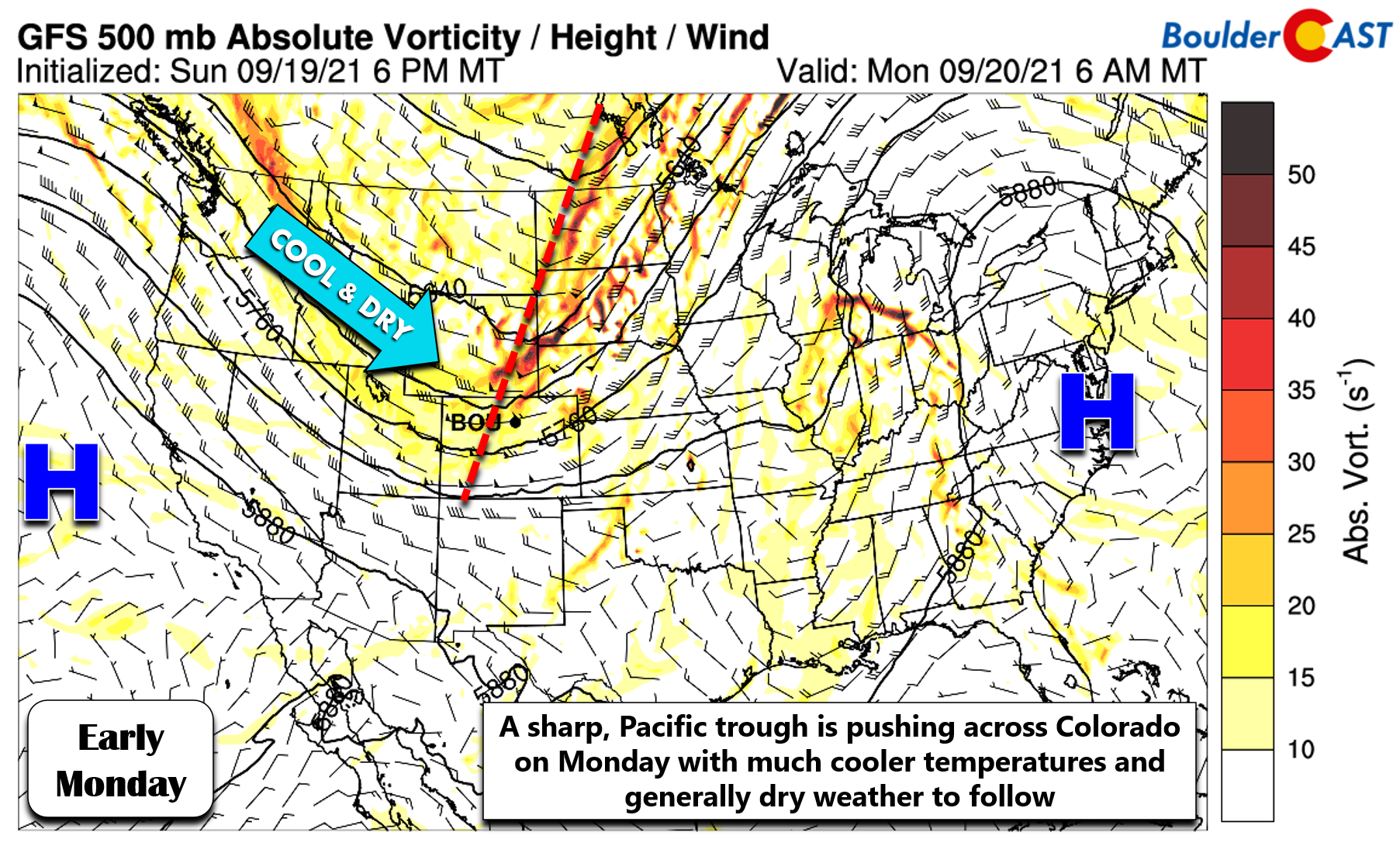
After yet another scorching weekend with temperatures well above normal, a strong cold front has blown through overnight which will allow for more seasonally-appropriate weather to start out the week. The front comes to us compliments of a sharp Pacific trough digging across the northern and central Rockies (see below). This is the most impressive atmospheric disturbance we’ve seen in northern Colorado since late-May. That’s not surprising, though. The seasons are in flux!
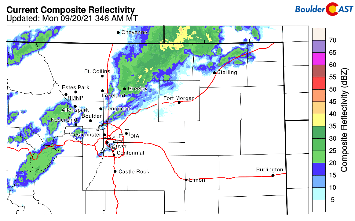
A few showers did slide across the Front Range early this morning before sunrise as front moved through from the northwest. The radar animation below was from around 4:30AM on this Monday.
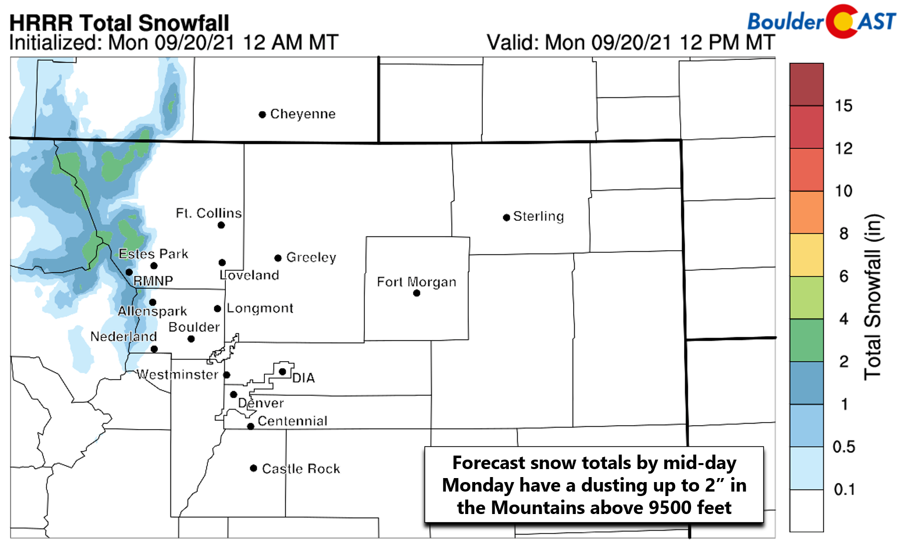
These showers were rain across the lower elevations and Foothills, but it was cold enough for some snow in the Mountains. Models are predicting anywhere from a dusting to 2″ of potential accumulation for elevations above 9500 feet.
Early morning webcams reveal a fairly widespread through light coating of snow in the Mountains. Here’s the sunrise view from Rocky Mountain National Park this morning:

Unlike last year, we’re not expecting any white stuff quite yet in the Denver Metro area, but it will sure feel like autumn to kick off the week as cooler temperatures have engulfed across the entire state of Colorado. Denver tied a record high temperature on Saturday at 93°F. On Sunday, it was a little cooler, but still very warm reaching the upper 80’s. Early this week temperatures will be some 20°F colder with both and Denver and Boulder struggling to reach 70 degrees on Monday. Of course this is a drastic change from the weekend but nothing too unusual for this time of year. Don’t forget that Wednesday is the official first day of fall! There is a slight chance of showers later Monday evening, but most of us will be dry enjoying a pleasantly cool fall day with plenty of sunshine.

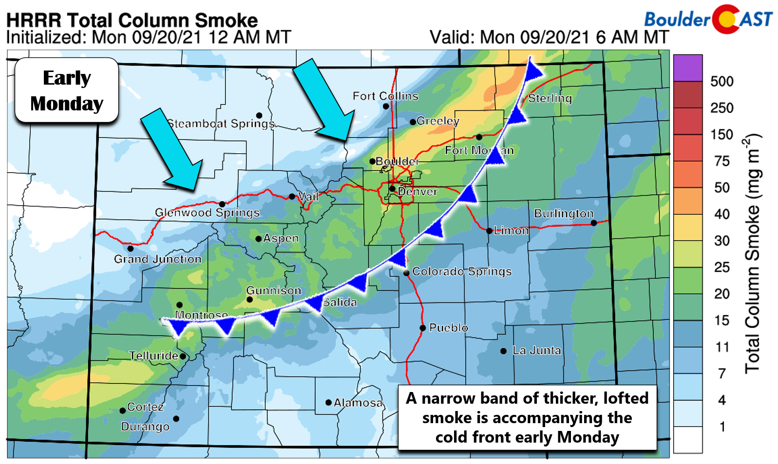
A narrow band of lofted smoke from the California wildfires is accompanying the cold front early Monday. There doesn’t seem to be much smoke at surface with PM2.5 air quality remaining good for now. Just don’t be surprised to see some haze or brown skies early Monday. The elevated smoke should be gone within a few hours!
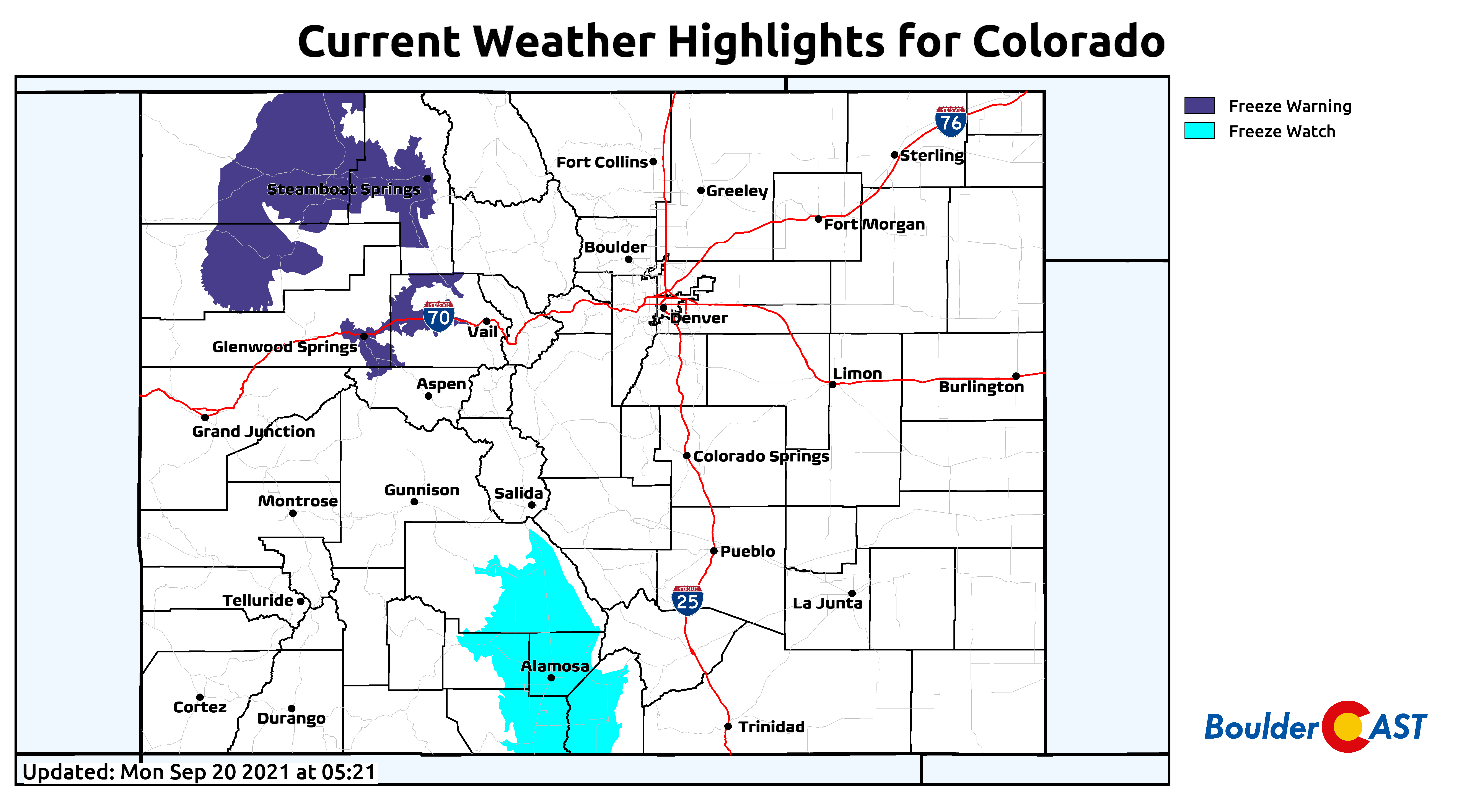
With clear skies Monday night into early Tuesday, chilly overnight lows are expected. Right now, we’re anticipating that most of the Denver-Boulder area will wake up to lower to middle 40’s Tuesday morning. However, outlying areas north and east of the city will likely drop into the 30’s. Frost is not entirely out of the question, but would be fairly isolated if it occurs at all. Freeze Watches and Warnings are in effect for some of the higher valleys across the state, a sure sign of the ongoing seasonal shift!
Tuesday will be dry and mostly sunny for us with temperatures remaining below normal in the 60’s as well.
*POST RELATED*
A dry & seasonal rest of the week
Behind the early week front, not only will it be cooler, but it will also be fairly dry as the post-frontal airmass is starved of moisture. The GFS moisture-anomaly forecast animation below shows that Colorado will be under a very dry airmass much of the week ahead. This animation ends Friday evening.
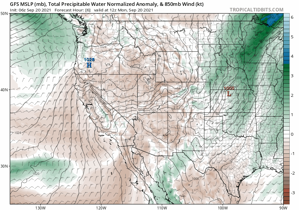
GFS moisture anomaly forecast animation spanning from Monday into Friday evening. Dry air will be parked over Colorado much of the week.
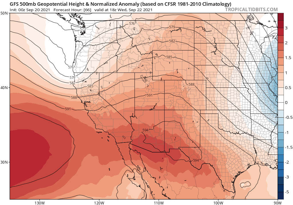
The large-scale pattern will shift and favor the development of a ridge of high pressure across Arizona and New Mexico by midweek. The GFS 500mb height anomaly forecast for midday Wednesday is shown below. Note the position of the high pressure to our south and the weak system entering northern California. Under this high pressure pattern, our flow will remain westerly or northwestly through much of the week keeping things fairly mild and tame. Right now it appears that temperatures will rebound nicely and stay in the 80’s Wednesday through Friday with no chances for precipitation and you guessed it: lots of sunshine!
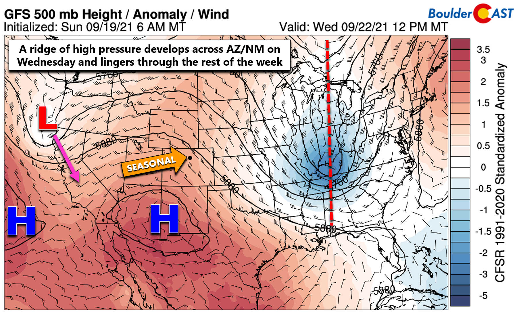
The weak California low shown above is projected to dive southward and stall as a cut-off system along the California/Baja border. While somewhat uncertain, this would have little to no impact on the Front Range for the time being. The only atmospheric cause for mild concern late in the week will be a strong storm system sliding into the Great Lakes for the upcoming weekend. You can see this disturbance towards the end of the animation below moving across Minnesota. Depending on the track of this storm, a cold front might clip northeast Colorado Thursday night into Friday. This is a big *might* though. Worst case scenario we end the week a little cooler in the 70’s if this front does indeed back into Colorado. More than likely though 80’s will continue….
Finally, don’t forget to get your submission in for our 7th Annual First Snowfall Contest which closes to entries TODAY (Monday September 20th). Based on the latest model projections, we may be waiting a while for our first snow so do predict accordingly… Have a good week!

Temperature and precipitation outlook for September 25-29 from the Climate Prediction Center
Stay up to date with Colorado weather and get notified of our latest forecasts and storm updates:
We respect your privacy. You can unsubscribe at any time.
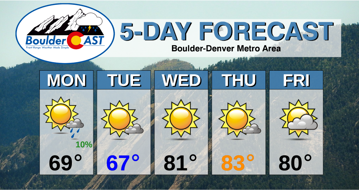
Forecast Specifics:
Monday: A few showers and blustery before sunrise, then mostly sunny and cool with just a slight chance of an evening rain showers. Highs in the upper 60’s on the Plains and middle 50’s in the Foothills.
Tuesday: Mostly sunny, dry and cooler. Patchy morning frost possible northeast of Denver. Highs in the mid to upper 60’s across the lower elevations with lower 50’s in the Foothills.
Wednesday: Sunny and warmer with highs around 80 degrees on the Plains and middle 70’s in the Foothills.
Thursday: Mostly sunny and warm with highs in the low to middle 80’s on the Plains and lower 70’s in the Foothills.
Friday: Partly sunny, but possibly cooler due to potential backdoor cold front. Highs likely stay in the 80’s across the Plains and 70’s in the Foothills.
Mountains: A dusting to 2″ of snow is possible in the northern Mountains early Monday morning with some light snow showers lingering through the day in northwest flow favored ranges. Both Monday and Tuesday will be chilly and blustery in the High Country. Things quiet down Wednesday through Friday with lighter winds and warmer temperatures expected alongside dry conditions. Check our SummitCAST page for up-to-date forecasts for more than 120 mountain destinations across Colorado, including all the 14ers.

Help support our team of Front Range weather bloggers by joining BoulderCAST Premium. We talk Boulder and Denver weather every single day. Sign up now to get access to our daily forecast discussions each morning, complete six-day skiing and hiking forecasts powered by machine learning, first-class access to all our Colorado-centric high-resolution weather graphics, bonus storm updates and much more! Or not, we just appreciate your readership!
.
Spread the word, share the BoulderCAST forecast!
.


You must be logged in to post a comment.