Happy Labor Day! This week will feature wildfire smoke building back into the region causing visibilities to deteriorate, especially Monday through Wednesday. With the exception of Tuesday, most of the week will see above average temperatures, even potentially record-breaking ones late in the week. All is dry, though unsettled weather increases over the upcoming weekend into early next week.
This week’s highlights include:
- Wildfire smoke returns, especially Tuesday and Wednesday after a frontal passage
- Most of the week to feature above average temperatures in the 90s, though a reprieve is forecast on Tuesday with a cold front
- Watching the potential for record highs late in the week in the middle 90s
- Dry all week long, maybe storms returning over the weekend

DISCLAIMER: This weekly outlook forecast is created Monday morning and covers the entire upcoming week. Accuracy will decrease as the week progresses as this post is NOT updated. To receive daily updated forecasts from our team, subscribe to BoulderCAST Premium.

Warm & hazy to start the week
An active weather pattern is in place over much of the nation and the Atlantic Ocean. The one exception is across Colorado and the West where high pressure ridging is largely in control. The figure below highlights the water vapor satellite as of yesterday afternoon. Hurricane Larry is churning over the central Atlantic and is expected to remain offshore, but may clip Bermuda later this week. There is a disturbance near the Yucatán Peninsula that may evolve into a tropical cyclone in a few days. If it does so, it may influence the Gulf Coast or northern parts of Florida. A few cold fronts exist over the eastern part of the country. As mentioned already, all is quiet in Colorado, though temperatures will be on the rise today…more on that soon!

Looking at the mid-levels of the atmosphere for Monday afternoon, we can see the dominating ridge of high pressure over southern Nevada. Increasing temperatures aloft will push our temperatures into the lower 90s on this Labor Day. There is a cold front slated to drop down from the north, currently over Montana and Idaho (below). That won’t penetrate into the Front Range until the overnight hours.
 The cold front will be well south of the area by Tuesday afternoon (below), ushering in cooler, more comfortable temperatures closer to average in the lower to middle 80’s. Enjoy this reprieve from the heat as this will be our coolest day of the week. As is often the case here, this front is a dry one with no threat of precipitation or storms in our forecast domain.

The frontal passage will shunt the anomalously warm temperatures into Utah, New Mexico, and Arizona (below), a nice break and probably our best day this week. The coldest air, however, will be over Minnesota and Wisconsin, as depicted by the green shading (cool anomalies).

Unfortunately, this cold front on Tuesday will shift our surface winds out of the north and northeast. The flow around the high pressure to our west will lead to the wildfire smoke building in across much of Colorado and the Front Range (below). The visibility and air quality on Tuesday will gradually deteriorate through the day as the higher concentration of smoke particles drift south from Wyoming.

As of Monday morning, Air Quality Alerts are already in effect for the entire Front Range Metro area from Fort Collins to Colorado Springs for ozone. We expect these alerts will remain in effect through much of the week ahead.

Heat & smoke take over Wednesday onward
Haze, smoke, and decreased visibility from wildfire smoke will persist at least through Wednesday given little change in the overall pattern to push the smoke out of our area (below). There may be improved conditions late in the week, but it is too early to tell for sure and will depend strongly on the surface flow.

The mid-level ridge (below) on Wednesday is expected to shift eastward as the trough which brought the cold front into the area Tuesday moves off towards the East Coast. There will be a few ripples or low pressure systems rotating around the ridge, specifically over Montana and parts of the Dakotas late Wednesday and Thursday. Most of these systems will stay to our north, but a pre-frontal trough is possible come Thursday that could marginally impact us. These impacts would only affect temperatures to some degree. Confidence is low on these features so the overall trend favors hot weather toward the latter part of the week.

Temperatures will rebound on Wednesday into the upper 80’s with more clouds around. As Tuesday is our coolest day of the week with the frontal passage, Thursday and/or Friday will be our hottest days. The 700 mb temperatures are forecast to reach 20°C, an airmass that usually favors middle 90s at a minimum during the summer months! Again, there may be a trough passage, but there won’t be much of a change in the airmass if a trough does indeed move through.

These hot temperatures will not only be in Colorado but across much of the West (below). Only the Northeast will be below normal.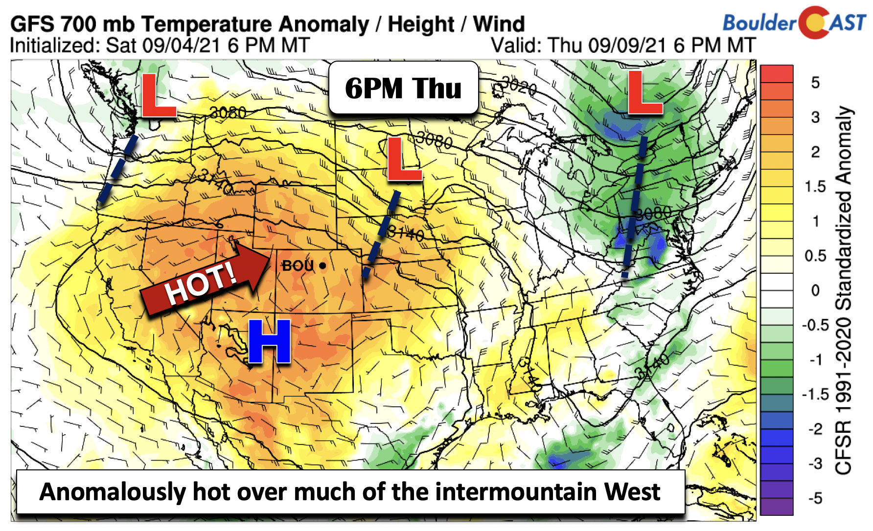
It is possible that we could see some record highs as a result come Thursday and/or Friday; the record high for Boulder on these days is 94 degrees. With forecast highs in the middle 90s, this will be very close!

Rain returns to the forecast this weekend & beyond
In the longer range, the global and ensemble guidance is showing that the ridge over the West may weaken and shift south a bit. In turn, the jet stream and a few troughs are poised to build into the Pacific Northwest and portions of the Rockies. These features normally would favor increasing chances of some showers/storms in Colorado, as well as a trend toward cooler high temperatures. This pattern is quite evident in the ensemble guidance forecast for Denver below. Virtually every day has a chance of showers/storms.

Enjoy the holiday and have a great week ahead! Be sure to get your entry in for our 2021 First Snow Contest!
Stay up to date with Colorado weather and get notified of our latest forecasts and storm updates:
We respect your privacy. You can unsubscribe at any time.
Forecast Specifics:
Monday: Sunny and warmer with highs in the lower 90’s for the Plains and upper 70’s in the Foothills.
Tuesday: Partly cloudy skies, smoke, and haze with highs cooler near the lower to middle 80’s on the Plains and upper 60’s in the Foothills.
Wednesday: Smoky and hazy under partly to mostly cloudy skies. High temperatures in the upper 80’s on the Plains and middle 70’s in the Foothills.
Thursday: Potential record high temperatures in the middle 90’s on the Plains and low 80’s in the Foothills under mostly sunny skies.
Friday: Hot and dry with near-record warm temperatures in the lower to middle 90’s for the Plains and near 80 in the Foothills.
Mountains: A very dry week is forecast for the majority of the High Country. A great week to be out and about hiking in the higher elevations for sure! Unsettled weather with a chance of afternoon/evening storms will return possibly on Friday and more likely over the coming weekend with isolated to scattered storms. Check our SummitCAST page for up-to-date forecasts for more than 120 mountain destinations across Colorado, including all the 14ers.

Help support our team of Front Range weather bloggers by joining BoulderCAST Premium. We talk Boulder and Denver weather every single day. Sign up now to get access to our daily forecast discussions each morning, complete six-day skiing and hiking forecasts powered by machine learning, first-class access to all our Colorado-centric high-resolution weather graphics, bonus storm updates and much more! Or not, we just appreciate your readership!
.
Spread the word, share the BoulderCAST forecast!
.


You must be logged in to post a comment.