In stark contrast to what transpired last week, the next handful of days will be warm and pleasant across the region with only minor chances of late-day thunderstorms. However, late in the week, a Pacific storm system will slide into the area, though it’s not exactly clear what the impacts will be across the Front Range. Read on for our complete forecast of the week ahead.
T
he weather this week will be much quieter and warmer compared to the gloom and snowfall we experienced last week. In fact, our main focus for the week ahead will not be a storm system at all. Instead, a large-scale rather sluggish ridge of high pressure will control things throughout the next several days across Colorado. The position of the ridge Tuesday evening is shown below.
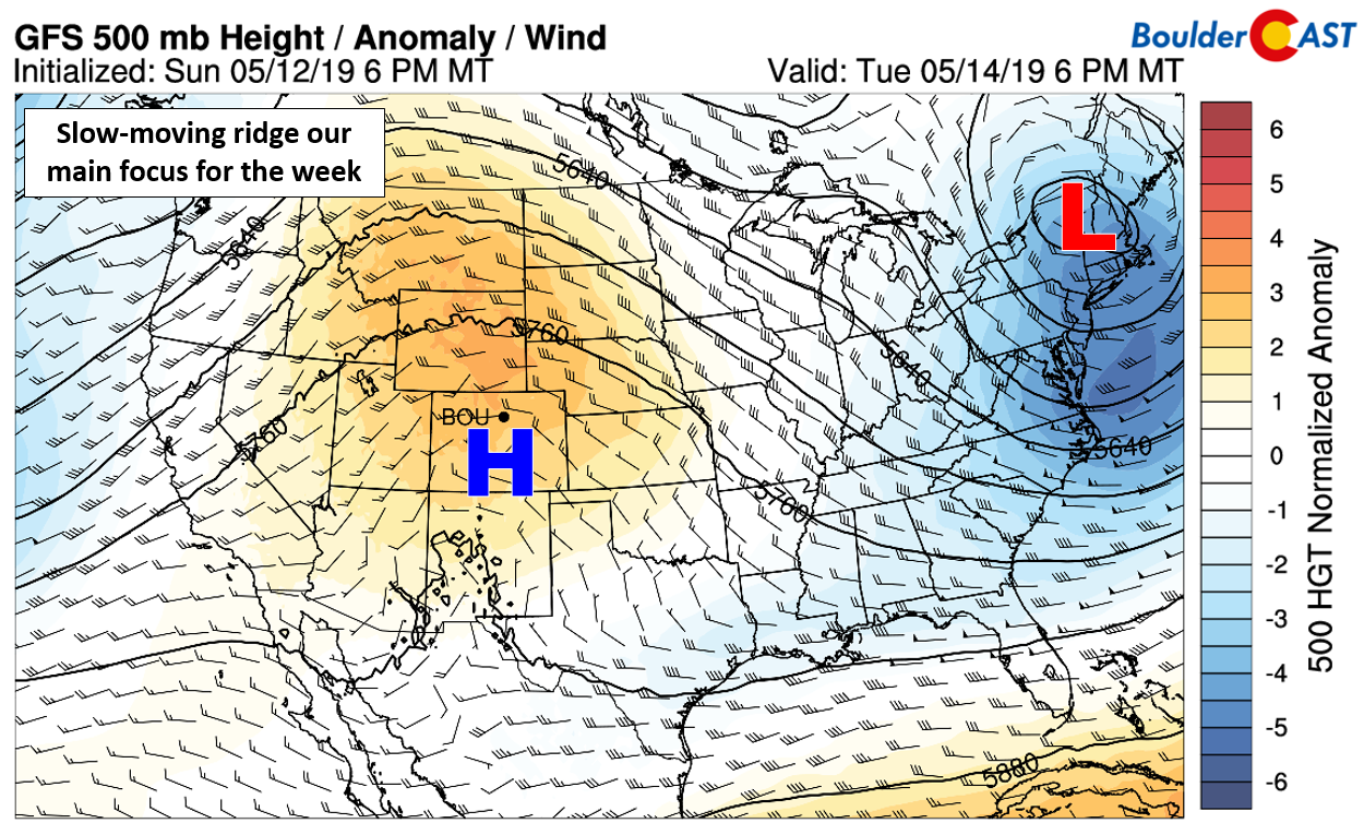
GFS 500 mb height anomaly forecast for Tuesday. A ridge controls the Rockies
This ridge will facilitate warm air advection across the central and southern Rockies early in the week, with persistence then keeping the airmass rather mild through Thursday. Across the Front Range, 700 mb temperatures will soar during this time, mainly falling between 10 and 14°C each afternoon this week. Given the good odds of partly to mostly sunny skies daily, high temperatures at the surface will respond accordingly reaching the middle 70’s to lower 80’s each day this week.
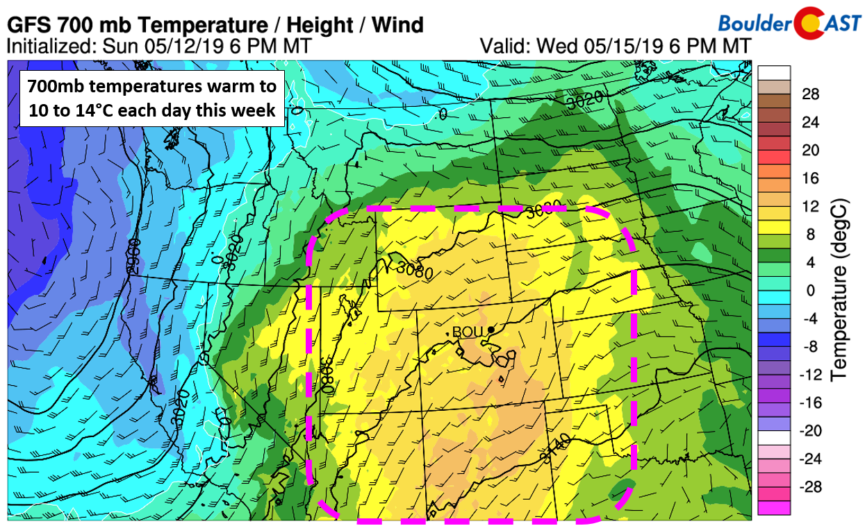
GFS 700 mb temperature and wind forecast for Wednesday
In terms of rainfall, chances will be rather slim (but non-zero!). Expect isolated afternoon and evening storms Monday, Tuesday, and Thursday. Wednesday looks to be the only day with completely dry conditions across the Metro area.
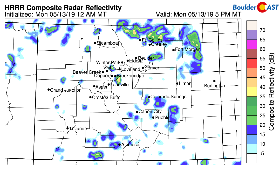
The high-resolution HRRR model simulated radar forecast for Monday evening predicts isolated showers and storms, mainly north and east of Denver and Boulder
The lower atmosphere will be very dry, especially Monday and Tuesday. This is evident from the forecast soundings. Monday afternoon’s skew-T plot for Denver is shown below. Notice the low-level inverted-V profile, basically an upside-down V, carved out by the temperature (red) and dew point (green) lines. This indicates that any storms which do form will be high-based, producing little in the way of rainfall, but could generate some lightning and gusty winds of 35+ mph.
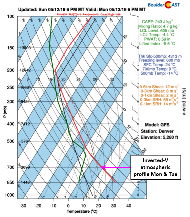
GFS forecast sounding skew-T plot for Denver for Monday
Overall, though, precipitation chances through the week are minimal which should result in most areas seeing only a few raindrops or nothing at all. The GFS and Euro models are indicating only spotty and light precipitation coverage through Thursday.
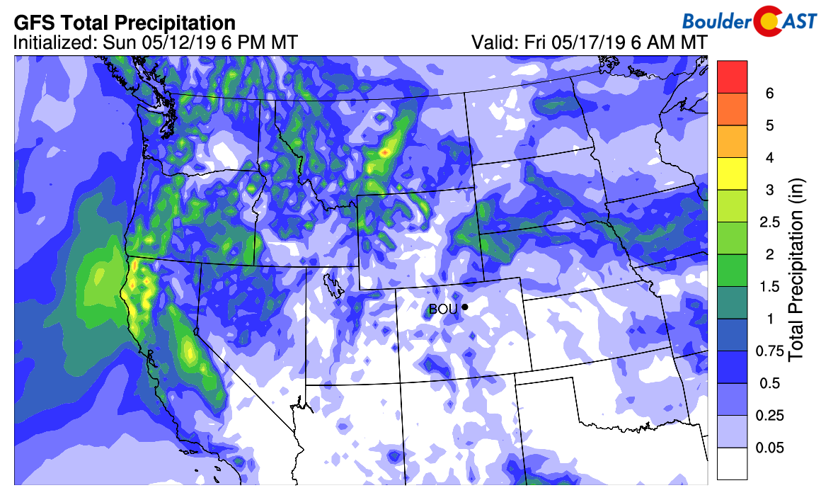
GFS total precipitation forecast through Thursday
Changes late in the week
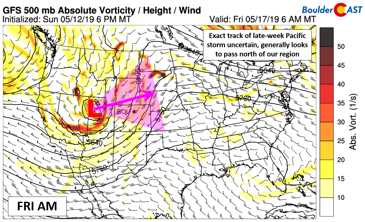
As we move towards the tail-end of the week, the ridge of high pressure will break down and be replaced with our next major storm system. After coming ashore in California on Thursday, the Pacific storm is expected to move eastward into the Rockies for Friday and Saturday. We’ll likely start to feel the effects of this system on Friday with cooler temperatures, more cloud cover, and slightly elevated chances for showers and storms. Snow showers will also be possible in the Mountains Thursday night into Saturday.
The exact track of this late-week storm remains uncertain, however. Current model forecasts want to take the system into Wyoming which would tend to downslope the Denver Metro area leading to only minor chances for precipitation. However, this track is not nailed down just yet. If this storm dives a little further south, as recent runs of the Euro model are showing, we could be looking at better chances for rain and Mountain snow Friday and Saturday.
For now, though, plan on cooler temperatures Friday (low to middle 70’s) with more cloud cover and slightly better odds of rain across the lower elevations. Temperatures for the weekend look to follow the cooling trend with highs in the 60’s to lower 70’s, though again, we’re not very confident in the exact weather set-up during this time. Weekend weather is still subject to change.
Forecast Specifics:
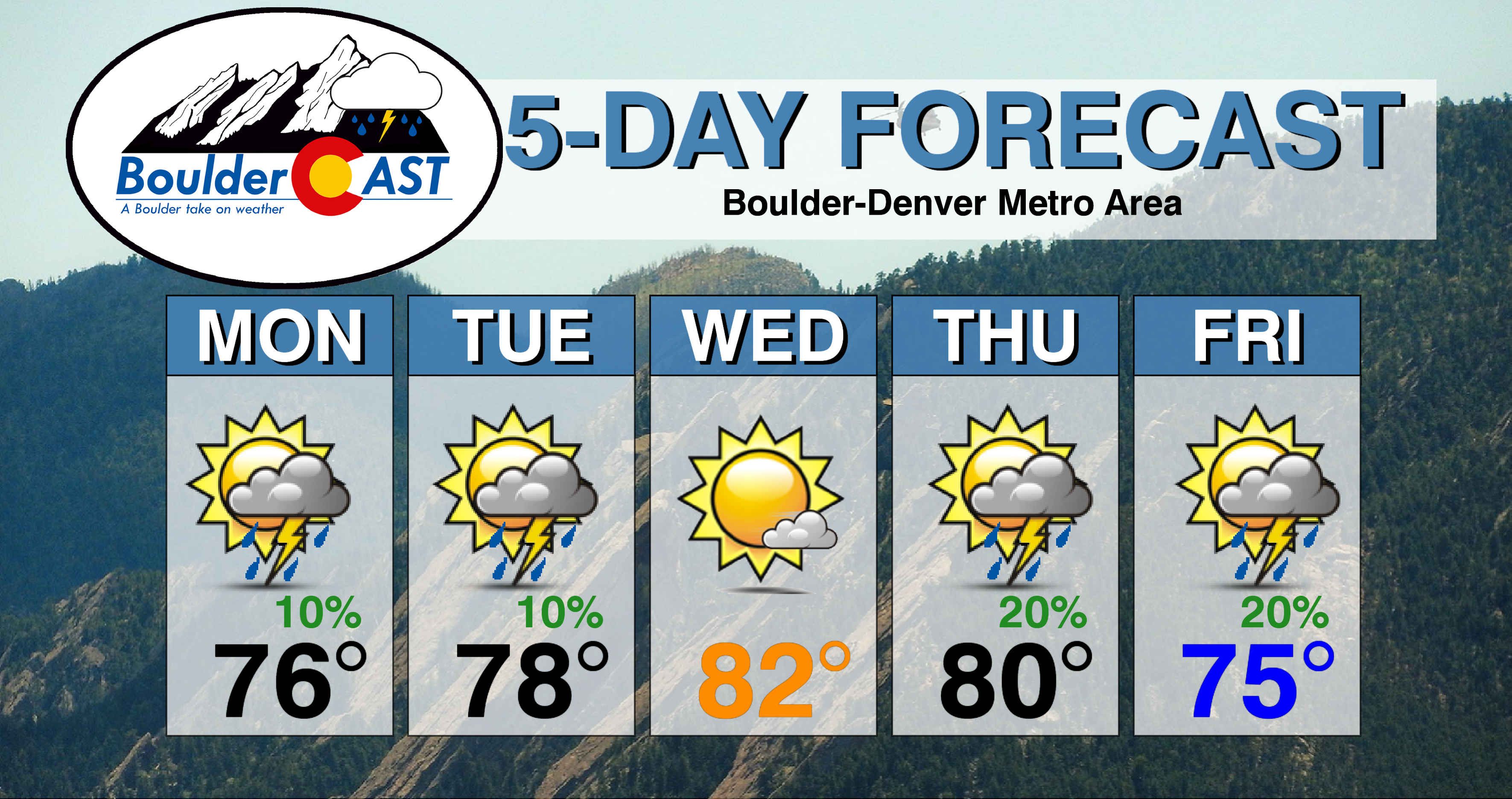
Monday: Partly to mostly sunny with isolated afternoon and evening storms, primarily north and east of Denver. Any storms that form could produce gusty winds but little in the way of rainfall. Highs in the middle to upper 70’s on the Plains and low 60’s in the Foothills.
Tuesday: Partly sunny with isolated afternoon and evening storms. Any storms that form could produce gusty winds but little in the way of rainfall. Highs in the lower 80’s on the Plains and upper 60’s in the Foothills.
Wednesday: Mostly sunny and warm with highs in the lower to middle 80’s across the Plains and near 70 degrees in the Foothills.
Thursday: Partly cloudy with isolated afternoon and evening thunderstorms, mainly north of Denver. Highs in the lower 80’s across the Plains with upper 60’s in the Foothills.
Friday: Cooler with more clouds and a chance of widely scattered afternoon and evening showers and storms. Highs in the low to middle 70’s across the Plains, with upper 50’s to lower 60’s in the Foothills.
High Country: Expect isolated to widely scattered showers and storms Monday through Thursday. Wednesday has the lowest chance of storms. A Pacific storm and associated cold front will impact the region Thursday night bringing a better chance of snow showers Friday and Saturday to the Mountains. Some minor accumulation is possible above treeline. Check PowderCAST for updated forecasts for all the Colorado ski resorts.
DISCLAIMER: This weekly outlook forecast was created Monday morning and covers the entire upcoming week. Accuracy will decrease as the week progresses as this post is NOT updated. To receive daily updated forecasts from our team, subscribe to BoulderCAST Premium.

.
Share our forecast!


You must be logged in to post a comment.