
Heat continues this week, especially early on, followed by an increased chance of storms for the latter part of the week as the monsoon begins to ramp-up. Read on for more details.
We start with the heat…
Now in the second week of July already – wow how summer is flying – the heat continues for the beginning of the week. Below shows the mid-level pattern on this Monday. Tropical Storm Chris is out churning east of the Carolinas. It is expected to remain offshore and move out to sea by the end of the week. An upper-level low is present in Oklahoma – this will be a player for us come Wednesday (as it is actually moving westward). Thirdly, high pressure remains over the western part of the state, keeping us dry and hot.
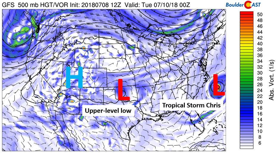
GFS absolute vorticity today
We can expect another toasty one today with temperatures in the mid to upper 90’s. In the low-levels (below), high pressure is situated to our east in Missouri. As you can see, the extreme heat is positioned right over us and across the much of the West. This same pattern will be with us on Tuesday as well. The High Country will see an elevated risk of showers and storms on Tuesday, about 30%. In somewhat of a rare situation, the steering flow across Colorado will be pushing the storms westward. Any storms that do form across the Mountains and Foothills will NOT be moving east across the Plains. Thus, we expect the Metro area to remain dry. This reverse flow set-up will persist through at least Wednesday, meaning just meager chances of rain for the Plains.
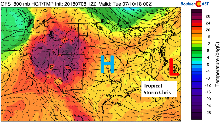
GFS 800 mb temperature this afternoon
We end with storm threat and slightly cooler
Come Wednesday, the aforementioned upper-level low that was over Oklahoma on Monday will have drifted westward into southeastern Colorado Wednesday afternoon. High pressure, meanwhile, will move off into Nebraska. The upper-level low will further increase storms across the High Country.
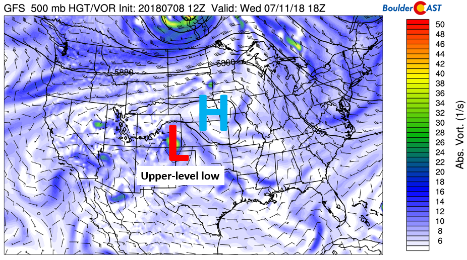
GFS 500 mb absolute vorticity on Wednesday
At the same time, lowering heights from the upper-level system will allow a weak cold front to move through northeast Colorado (see below). That will help lower highs (likely lower 90’s) and create weak forcing for showers and thunderstorms. The front will only partially move through on Wednesday, but help just enough to raise moisture levels, increase clouds, and allow storms to develop slightly further east on the Plains as opposed to only across the higher elevations as was the case earlier in the week. Still, most of the stormy weather should remain over the higher terrain on Wednesday considering the steering flow, with just isolated storms across the Metro area.
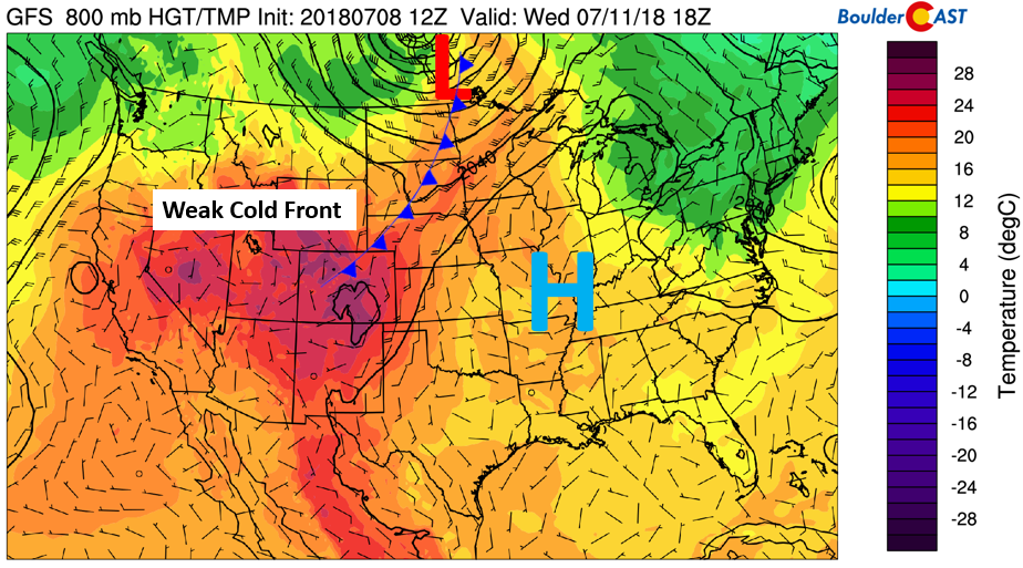
GFS 800 mb temperature on Wednesday
The below pattern will be with us Wednesday and Thursday, and even parts of Friday, with the front lingering nearby (see below). As you can see, the storms slowly edge from the High Country to the Plains over the latter part of the week with the front moving from south to north by Thursday.
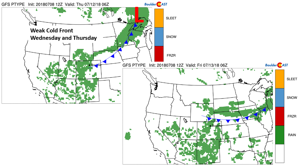
Precipitation chances Wednesday and Thursday
On Friday, a similar pattern will exist. However, the main difference is that northwesterly upper-level flow will start to take over. That will allow high pressure to move further west into Nevada. Weak frontal systems in the northwest flow and embedded shortwaves will continue our threat of storms. This pattern will eventually allow a cold front to possibly push through in the late weekend to early next week time frame…so stay tuned. By late in the week, there will also be an abundance of subtropical moisture pooling across the Four Corners from the commencement of the summer monsoon. All in all, we can expect storms to remain in the forecast this coming weekend, especially for the higher elevations.
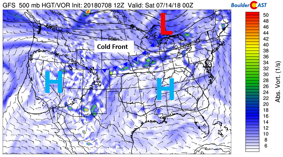
GFS 500 mb absolute vorticity Friday
Forecast Specifics:
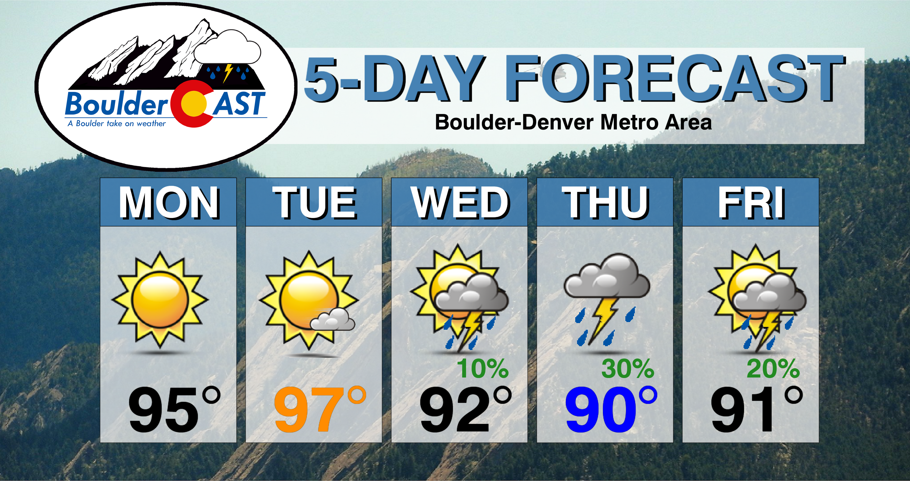
Monday: Sunny and hot with temperatures in the mid to upper 90’s on the Plains and middle 80’s in the Foothills.
Tuesday: Sunny early, then partly cloudy with a few pop-up thunderstorms possible in the Foothills. The Plains should be dry. Highs topping out near the upper 90’s for the Plains and middle 80’s in the Foothills.
Wednesday: Sunny skies changing to partly cloudy skies in the afternoon thanks to a weak cold front. Expect widely scattered late afternoon and evening thunderstorms, mainly across the higher elevations. High temperatures in the lower 90’s across the Plains with upper 70’s in the Foothills.
Thursday: Some sunshine giving way to afternoon clouds. Scattered thunderstorms will develop through the evening, some producing heavy downpours. Thursday will be the best chance of rainfall for the Denver Metro area. Highs near 90 degrees for the Plains and in the upper 70’s in the Foothills
Friday: Increasing clouds with isolated thunderstorms possible for the afternoon and evening, particularly across the higher elevations. Highs in the lower 90’s for the Plains and into the lower 80’s in the Foothills.
High Country: Storms will be a threat across the Mountains throughout the week, with the exception of Monday. Dry and warm air aloft will keep any storms few and far between today. Increasing scattered to widespread storms will then take over Tuesday through Friday, so be sure to hike early to avoid getting into trouble on the descent. Check out SummitCAST for twice daily updated forecasts for over 120 Colorado hiking destinations!
DISCLAIMER: This weekly outlook forecast was created Monday morning and covers the entire upcoming week. Accuracy will decrease as the week progresses as this post is NOT updated. To receive daily updated forecasts, subscribe to BoulderCAST Premium.

.
Share our forecast!


You must be logged in to post a comment.