With the first full-week of July coming to a close, monsoon season is right around the corner for northeast Colorado. However, its arrival is not something you can mark on the calendar as there is no set date for its commencement. It fluctuates substantially from year to year, depending greatly on the weather patterns of Mexico, the southeast USA, and the tropical eastern Pacific Ocean. We discuss the current state of the atmosphere and when we expect the monsoon to finally arrive.
The onset of the monsoon
The diagram below shows the typical set-up for the North American Monsoon. A “monsoon” low pressure in southern California often teams up with high pressure in the south-central United States to funnel relatively large quantities of low and mid-level moisture northward into the Desert Southwest. This moisture is key to forming widespread monsoon thunderstorms that are a staple of our Colorado summers.
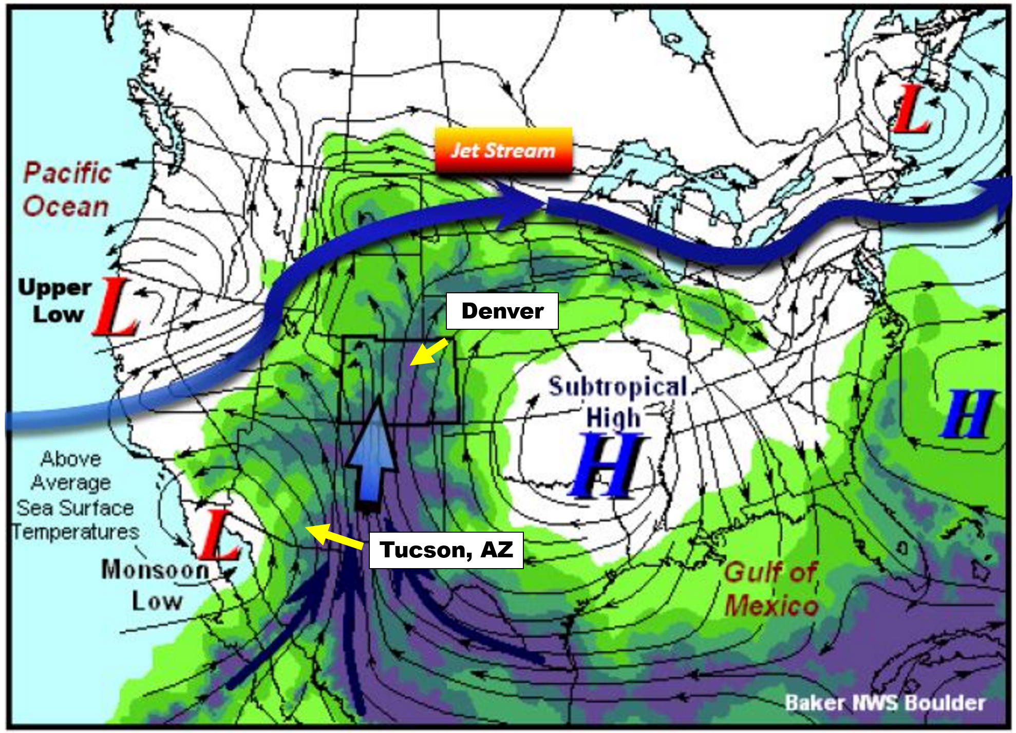
Monsoon set-up diagram | NWS Boulder
One way that we track the arrival of the North American Monsoon is to monitor surface dew points in southern Arizona. Cities like Tucson (see location above) are much closer to the source of the moisture than we are here in Denver. The moisture more-or-less has to pass through Tucson as it moves northward into the United States. Tucson is also a pivot-point for the moisture plume itself. Think of Tucson as the “faucet”, with a “hose” of moisture wandering northward. Sometimes the hose if over Nevada, other times it meanders over Utah or Colorado.
While our monsoon is sporadic throughout July and August, the faucet is nearly continuous for Tucson. For this reason, Tucson actually sees more monsoon rainfall than Denver on average, and has a more predictable and consistent monsoon climatology.

It is largely agreed upon that monsoon season’s official start is when the average daily dew point in Tucson is at least 54 degrees for three consecutive days. Seriously, this is a real thing that is closely monitored by meteorologists and residents of that area. We can’t blame them…July’s average rainfall exceeds the combined total for March, April, May and June in Tucson (above plot on the left). The monsoon is a much bigger reprieve for them than it is for us, especially considering the edge it can take off of those 115-degree afternoons…
The two graphs below show the daily average dew point values at Tucson Airport. The blue line is the actual data from 2018. The red line is climatology and the green line is the coveted 54-degree threshold for the monsoon.
2018 monsoon season dew point tracker | NWS Tucson
As you can see from the graph on the right, yesterday’s average dew point was 58 degrees, with 51 on Friday and 52 on Thursday. Comparing this year to average (the red line), monsoon season is right on-track. We are VERY close to the official start, but not quite there yet.
When will the monsoon begin?
Based on model data for Tucson, the requirement of three consecutive 54+ degree dew points will be reached early this week. The third consecutive day, marking the official beginning of monsoon season, may happen as early as Monday (tomorrow).

GFS forecast moisture anomaly animation through Sunday July 15, 2018.
This moisture will still take a few additional days to propagate into Colorado. Based on this timeline, we expect the monsoon to start becoming more active Colorado by the mid to latter part of the week ahead. The large-scale pattern for the end of the week looks very similar to the “cookie-cutter” monsoon pattern we showed earlier….a broad high pressure is set to be across the south-central United States.
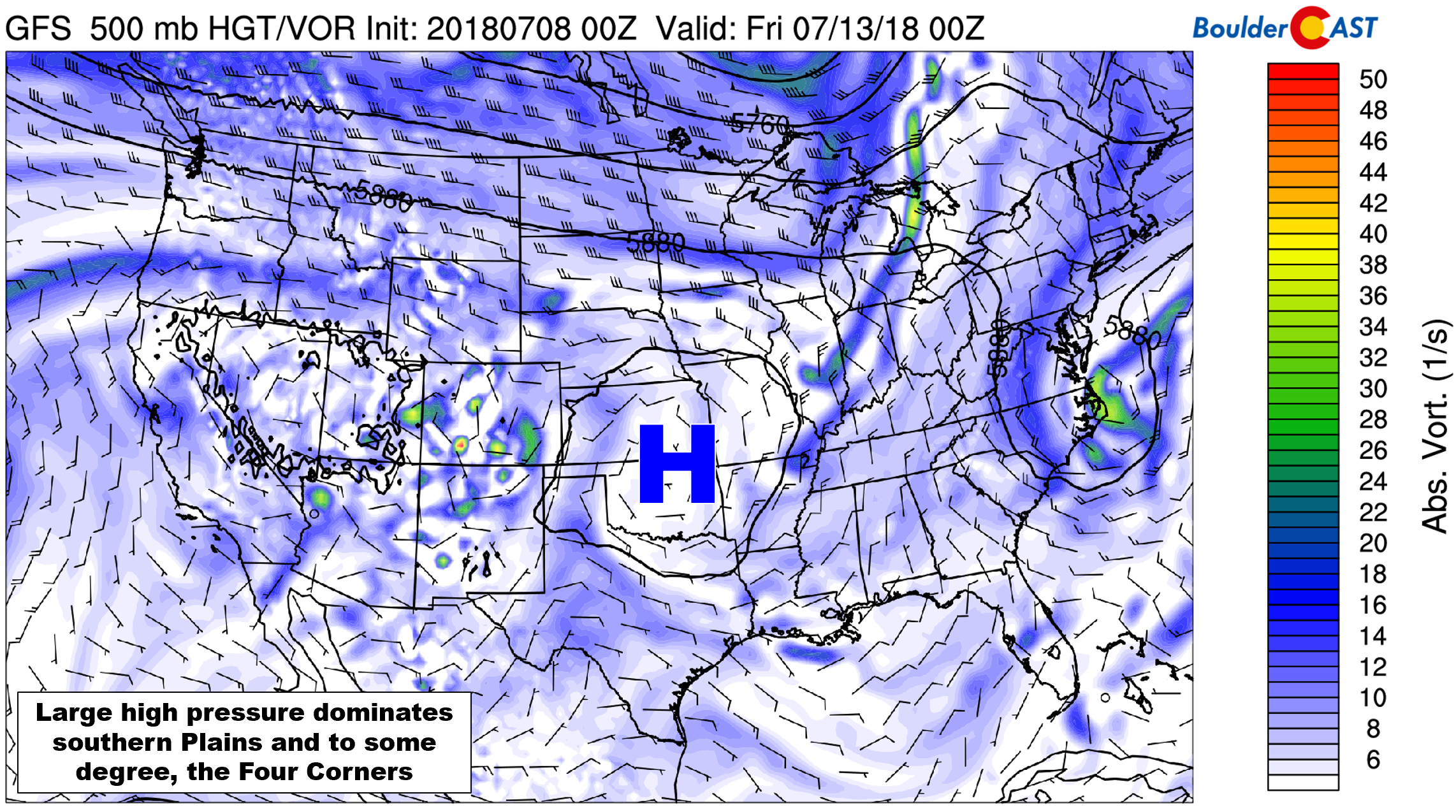
GFS 500mb vorticity map for Thursday is a monsoon pattern
Monsoon moisture will combine with strong solar heating to spread showers and thunderstorms northward across the Four Corners region through the week (see below). However, despite the GFS painting Colorado with significant rainfall, the core of the monsoon plume will remain to our west across Utah and Nevada through the week. The pooling and re-circulation of the moisture will bump storm chances across Colorado’s Mountain nonetheless. The impact for the lower elevations and the Metro area remains to be seen. We’ll talk more specifics in our weekly outlook tomorrow.

GFS total precipitation forecast through Friday night.
Along with that increased chance of daily thunderstorms, the monsoon brings more dangerous alpine hiking conditions, frequent evening rainbows, warmer nights, more lightning to spark wildfires, and “stickier” air overall. After today’s near-100 degree heat, we’re certainly ready for it!

Spread the word, share this post!
.


You must be logged in to post a comment.