We begin the week under the protective influence of a mid-level ridge of high pressure. With this, the Front Range will be (mostly) dry and at times very warm through the week. Read on for our short and to-the-point weekly outlook.
The week ahead will fall into a rather monotonous period of weather which we outlined in our post last Thursday. A large ridge of high pressure has built across the western United States over the weekend (see below).
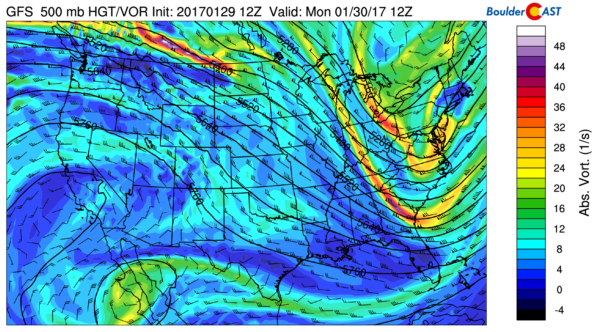
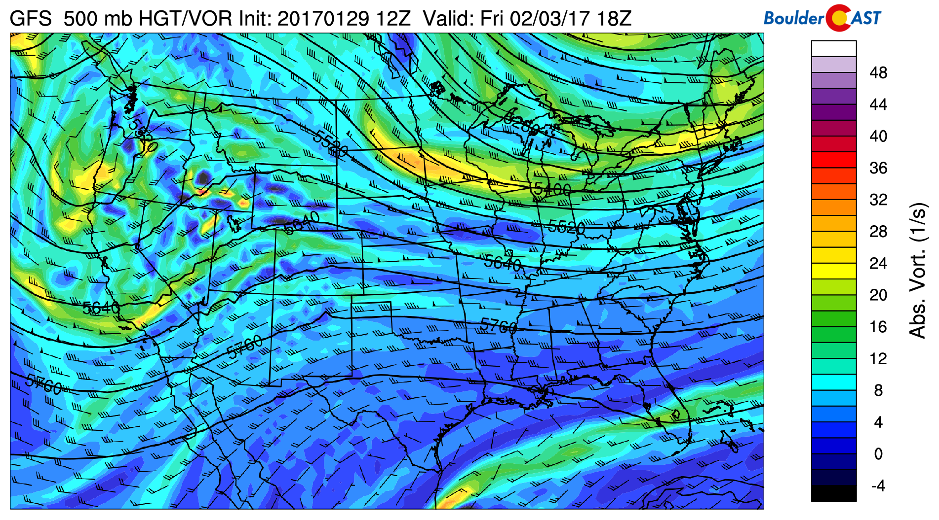
GFS 500 mb vorticity map for Monday morning, showing the large ridge centered across California with influence spreading eastward through Colorado
This ridge has pushed the jet stream and associated storm track into Canada…
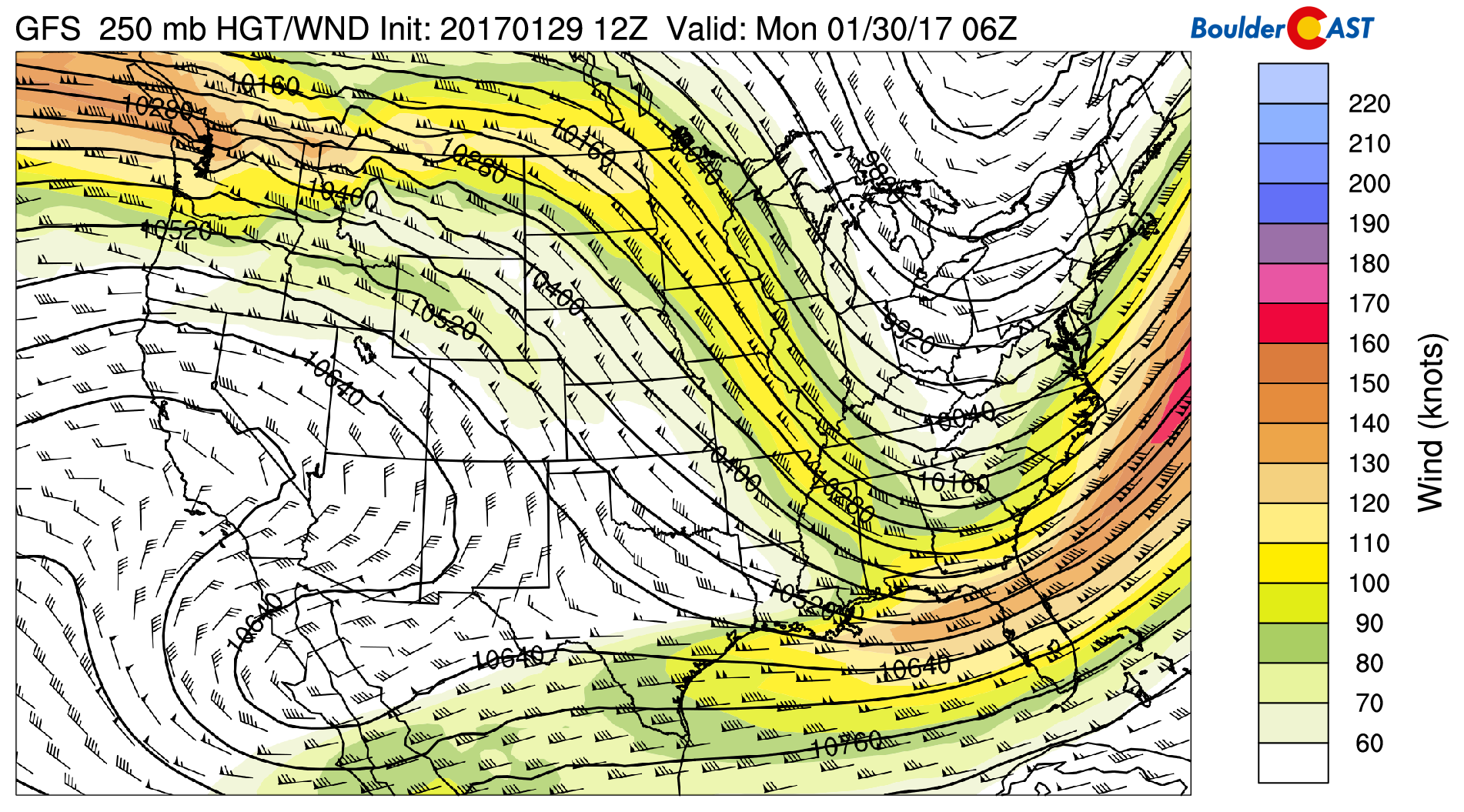
GFS 250 mb height and wind speed forecast for Monday, showing the current position of the jet stream straddling the US/Canadian border
While northwest winds typically bring snow to the Mountains, this flow will be fairly dry and the downward forcing from the presence of the ridge will win out. Therefore, we’re not expecting any precipitation state-wide through Wednesday.
The story instead will be the temperatures!
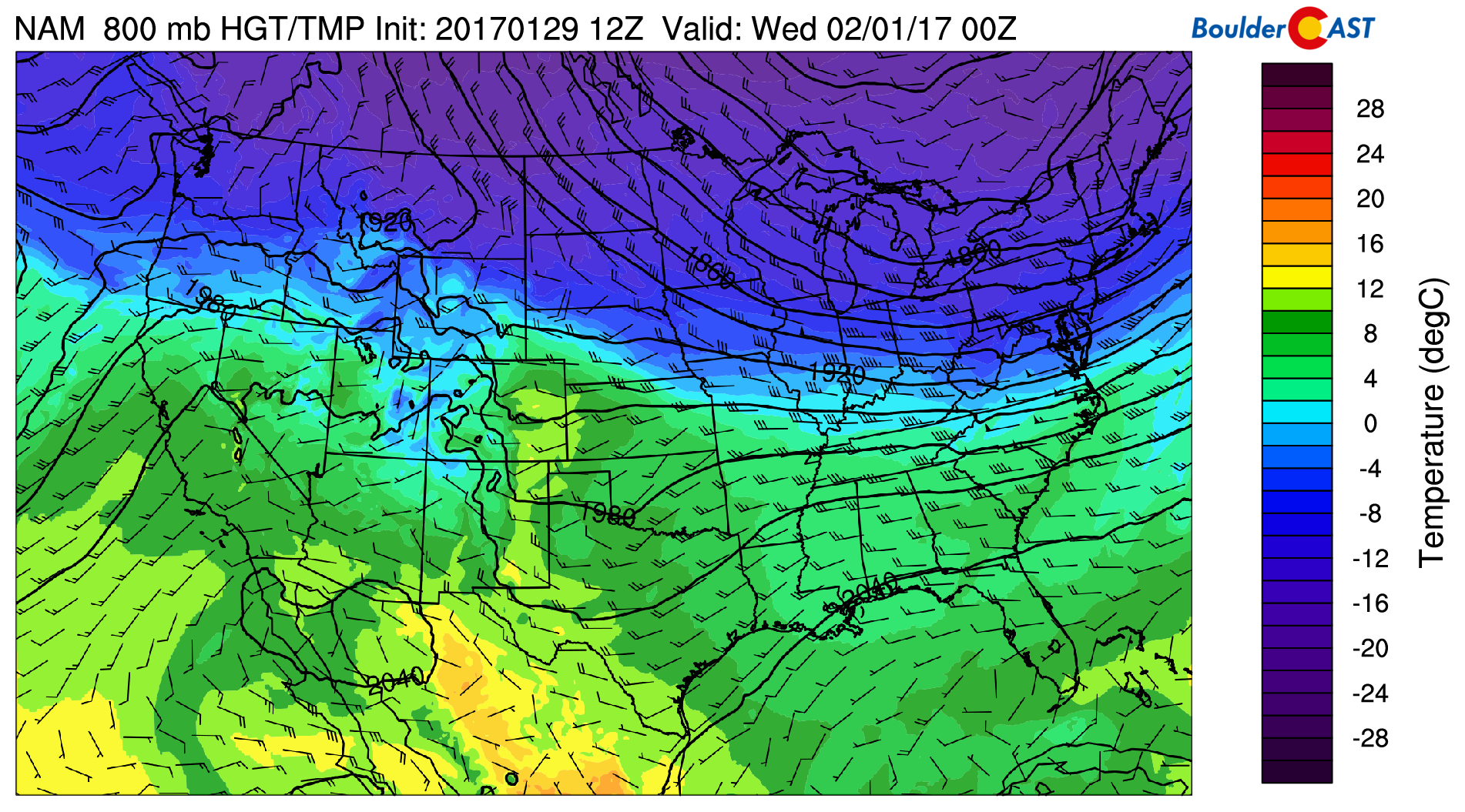
Underneath the ridge, warm and dry northwest flow will boost temperatures into the 60’s both Monday and Tuesday, some 20 degrees above average. The 800 mb temperature map for Tuesday afternoon below shows a tongue of very warm air stretching northward into eastern Colorado. However, notice that the cold wrath of winter is looming just one state away in Wyoming! This cold airmass will be a player for the second half of the week…
Enjoy the warmth… It looks as though that cold air will be moving into northeast Colorado Tuesday night behind a dry cold front. There isn’t much forcing from either side of the front, so we’re not too confident in the timing at this point. Some models delay the front until later on Wednesday morning. This of course, will have implications for our temperatures on Wednesday. Expect somewhere between the low 40’s and low 50’s, with partly sunny skies. It’ll definitely be colder than the two days prior.
Thursday and Friday to be more seasonal
By late week, that cooler air mass should be fairly entrenched across the region. At the mid-levels, we’ll still be under the influence of a shortwave ridge. The 500 mb vorticity map below shows the ridge axis centered over western Colorado Friday afternoon.
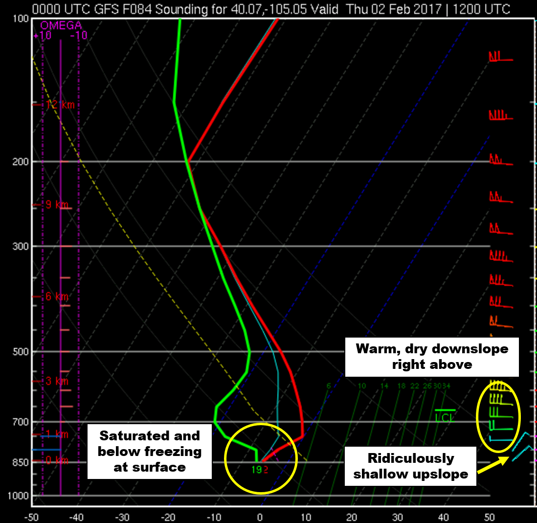
However at the surface, another surge of cool air will bank up against the Foothills Wednesday night into Thursday morning, potentially creating another round of freezing fog. It’s unclear exactly how much moisture may be available to produce precipitation (in the form of snow pellets and freezing drizzle), but it could be somewhat similar to the event we had last week if this push does verify. The GFS forecast sounding below for 5AM Thursday shows the very shallow upslope and saturated fog layer right at the surface. With warmer and drier downlsope capping things aloft.
Despite this wintry threat, expect highs for Thursday somewhere in the low to mid 40’s. Friday will be tad warmer and a little sunnier.
There is also a slight chance of a few snow showers in the Mountains, particularly Friday. However, they will be very isolated and likely not amount to much in the way of accumulation.
Extended still quiet
With the ridge gone, a trough may finally be coming ashore in California by Friday (see above). This should translate into snowfall for the Mountains at some point this weekend. Right now the timing is during the day Saturday. This of course if highly subject to change at this point. This is not a favorable set-up for precipitation at the lower elevations, so we’ll expect more dry and seasonal weather this weekend for now.
We’re also see more indication for next week of another ridge rebuilding across the West. This could very well translate into another quiet second week of February, too…
Forecast Specifics:
Monday: Partly sunny and warm with a high in the low 60’s across the Plains and in the low 50’s in the Foothills.
Tuesday: Another warm day, possibly warmer than Monday. Expect highs in the low to mid 60’s for the Plains, with low 50’s in the Foothills. Skies will be partly to mostly cloudy with high clouds overhead.
Wednesday: Mostly sunny and continued dry. High temperatures will be cooler in the mid 40’s on the Plains and mid 30’s in the Foothills.
Thursday: Mostly cloudy early with sun in the afternoon. We’re tracking a slight chance of wintry precipitation during the morning hours. Freezing fog, flurries, and freezing drizzle may be possible. Highs will be in the low to mid 40’s on the Plains with mid 30’s in the Foothills.
Friday: A mix of clouds and sun with highs in the upper 40’s. The Foothills should warm into the mid to upper 30’s.
High Country: Expect a quiet week for the Mountains as dry weather prevails through Wednesday. By late Thursday through Friday, a very slight chance of snow will be possible in the Mountains north of Interstate 70 mostly. A little accumulation could be possible, but don’t place any bets for powder.
Mon
Tue
Wed
Thu
Fri


Temperature
62
64
47
44
49


Precip Chc (Plains)
0%
0%
0%
10%(am)
0%


.


You must be logged in to post a comment.