Monsoon moisture is making its annual retreat back into northwestern Mexico. When this happens, we look to the mid-latitude storm track to begin providing “weather” to Colorado again through the autumn season. Unfortunately, the storm track remains well to our north right now, so prepare for a generally quiet week ahead.
High fire danger Monday 🔥
We begin the week with a bi-polar pattern present across the United States. A dome of high pressure is holding over the East Coast, while a fall-like trough of low pressure is situated across the Northern Rockies. On Monday, Colorado will be at the base of this trough with strong downslope winds present.
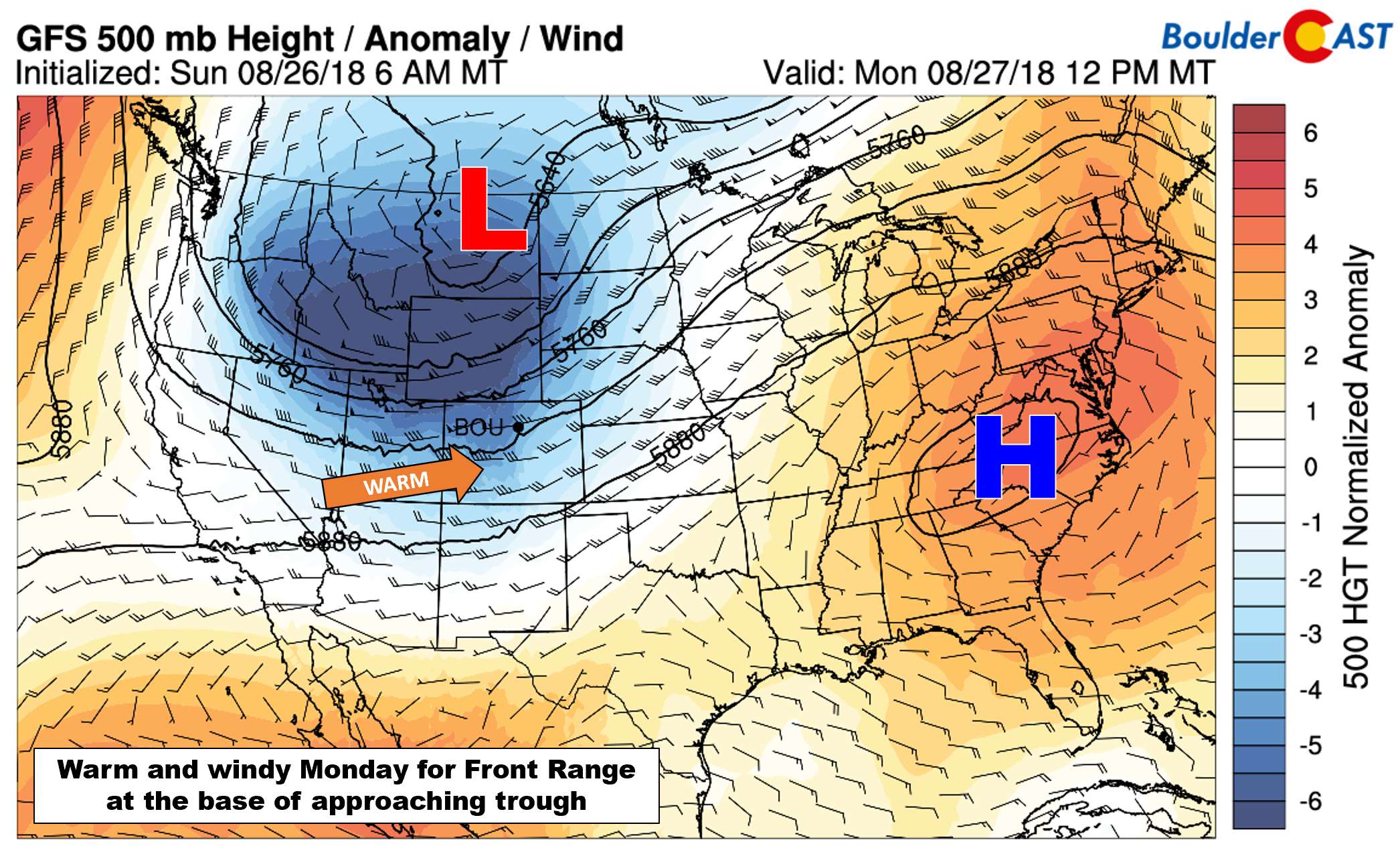
GFS 500 mb height anomaly forecast for Monday
Notice the spike in 700 mb wind speeds just east of the Continental Divide across most of Colorado this morning and the dip in the height lines (below). This is a mountain wave signature. Of course, models aside, the wave clouds visible out there tell basically the same story. Wind gusts near the Divide and in the Foothills could reach 50 mph Monday morning.
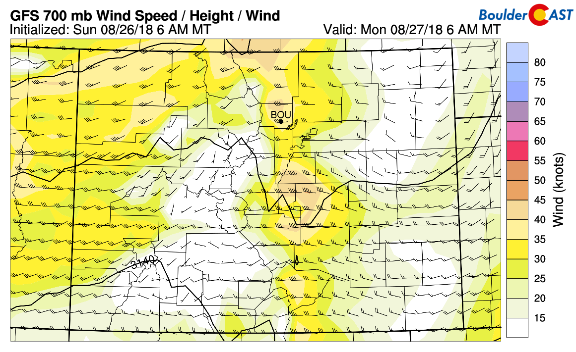
GFS 700 mb wind speed forecast for Monday morning at 6:00 AM. Moderate winds are indicated in the lee of the Rockies.
As the day wears on, these stronger winds aloft will mix down to the surface, keeping things HOT, BREEZY and DRY for the Metro area. As you know, those three words together mean dangerous fire conditions. Red Flag Warnings are posted for today…be extra careful. We could see gusts during the afternoon reach to 30 mph alongside temperatures in the lower 90’s.
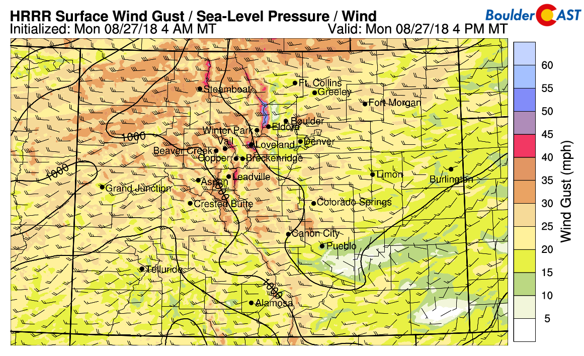
HRRR surface wind gust forecast for Monday afternoon. It’s going to be a breezy day for much of Colorado!
Cooler Tuesday with a few evening sprinkles 🌧️
Fortunately the trough will not delay too much in moving eastward. Wildfire conditions improve considerably for Tuesday with the passage of the cold front associated with the trough. The front should arrive around midnight Monday night, making for a much cooler day on Tuesday across northeast Colorado.
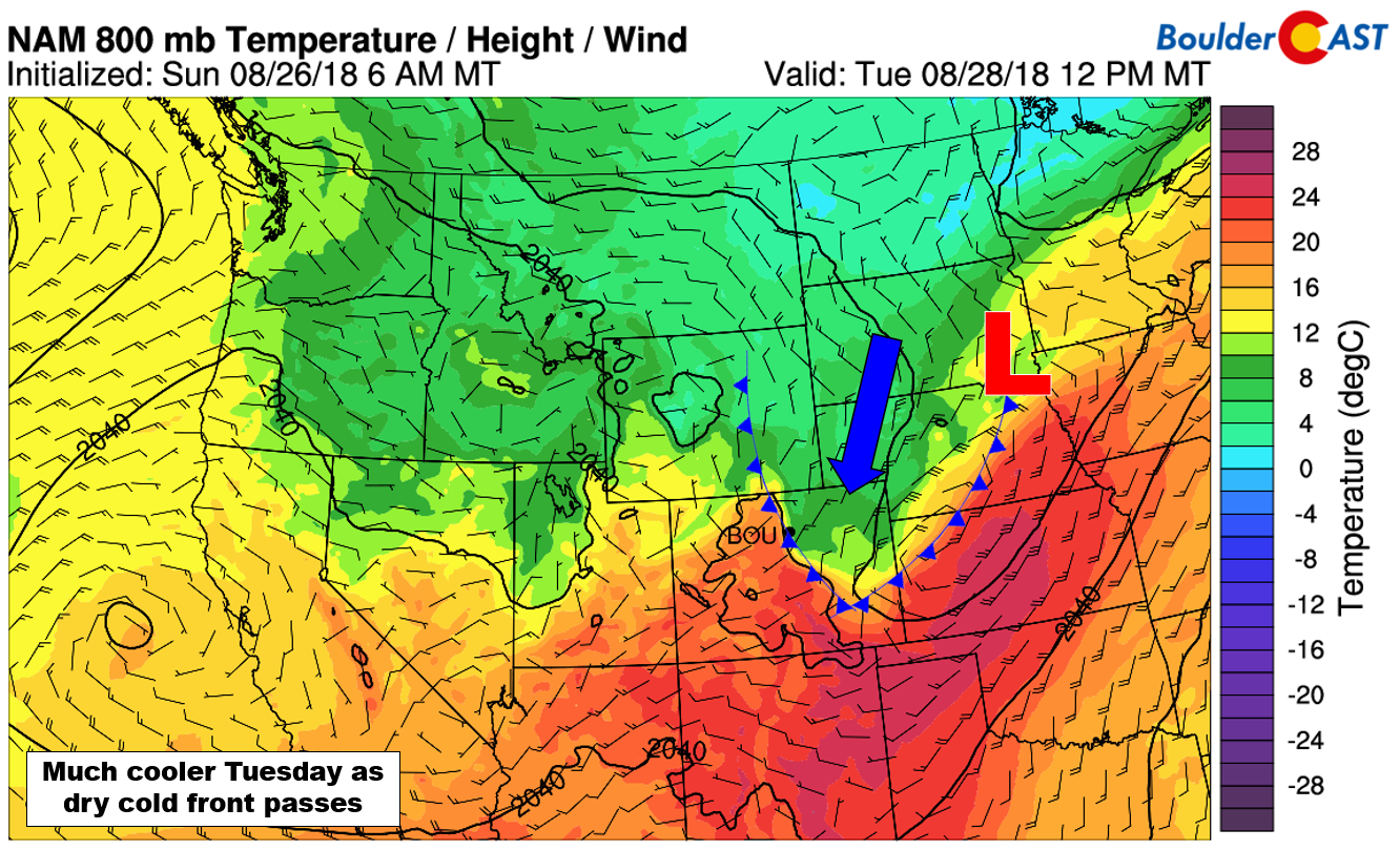
NAM 800 mb temperature and wind forecast for Tuesday afternoon. The cool airmass will be in place across northeast Colorado.
There is very little moisture associated with the front….and actually very little present for the entire western United States (see below). Thus, we’re not expecting much in the way of precipitation on Tuesday.
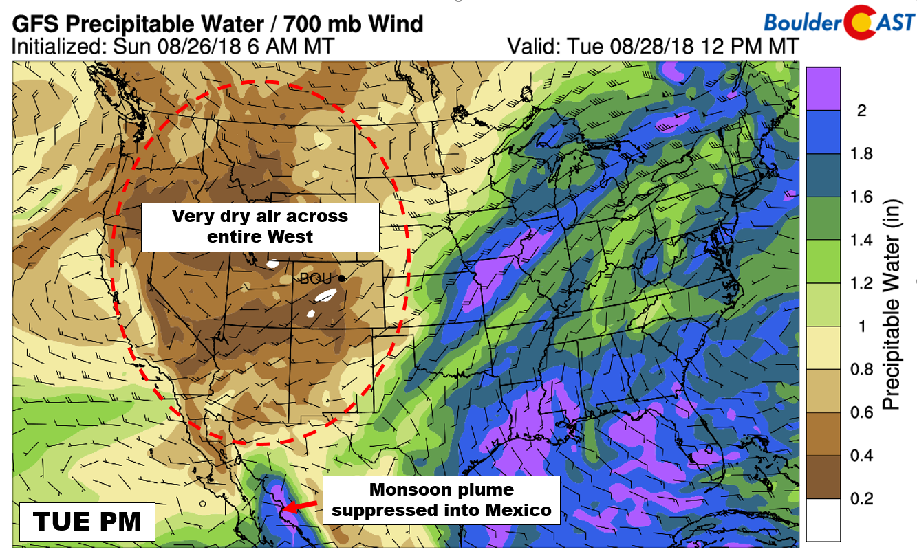
GFS precipitable water forecast for Tuesday afternoon. Dry air is set-up over the entire western United States. The monsoon has retreated.
Nonetheless, both the GFS and the NAM models are showing a brief chance Tuesday evening. Everything wraps-up before midnight in the Metro area. Any precipitation we see will likely be just a few sprinkles or light rain showers. The cooler air from the trough will bring snow levels down below 12,000 feet elevation during this time.
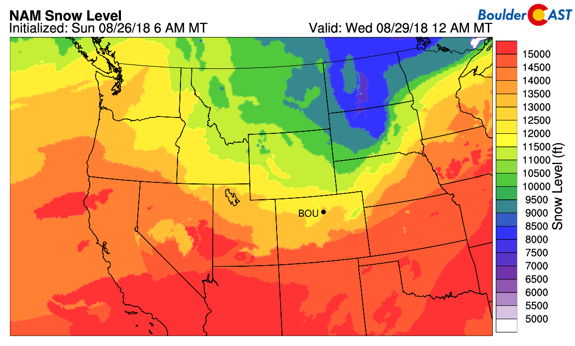
NAM model-derived snow level forecast for Tuesday night.
Thus, a few flurries or snow showers can be expected in the highest mountains north of Interstate 70…such as Longs Peak…
Temperatures on Tuesday will be refreshing east of the Continental Divide. Look for highs in Boulder and Denver in the middle 70’s, with 60’s in the Foothills.
Finally, the post-frontal airmass will have elevated smoke content. A large portion of the incoming smoke will be from a new large fire burning just northwest of Cheyenne. Expect visibility and air quality to drop on Tuesday as a result. The good news (for us) is that the huge conglomeration of smoke across the Pacific Northwest has generally been swept into the Great Lakes and Northeast and become less concentrated overall. Thick smoke and disappearing Foothills are not in our forecast this week.
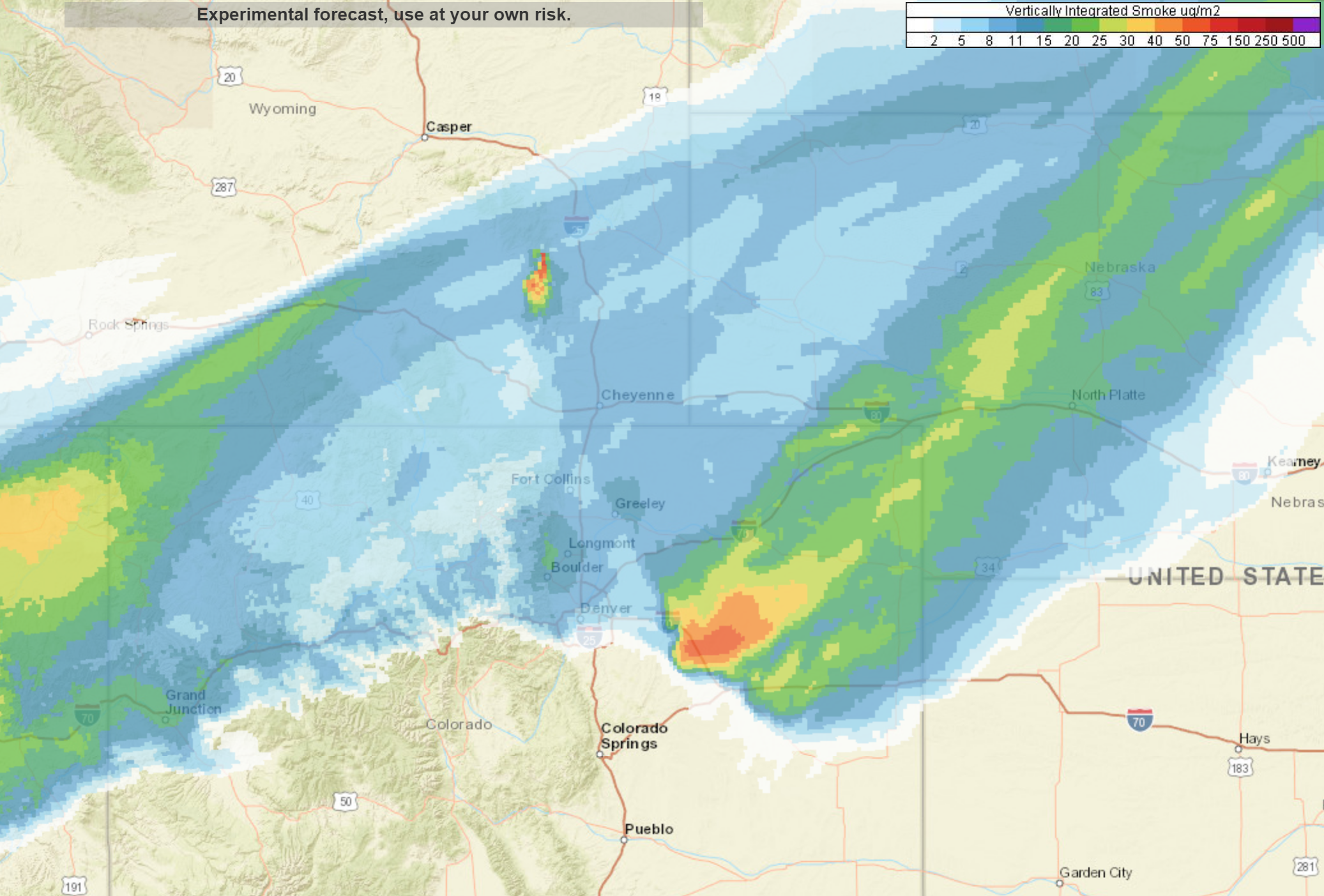
HRRR-Smoke total smoke forecast for early Tuesday morning. Light smoke returns to the Metro area.
Dry & warm for the rest of the week
Flow throughout the remainder of the week will be westerly or west-southwesterly through Friday with a ridge of high pressure strengthening across New Mexico and Arizona. This will lead to pleasant conditions for our region with generally sunny skies and warm temperatures.
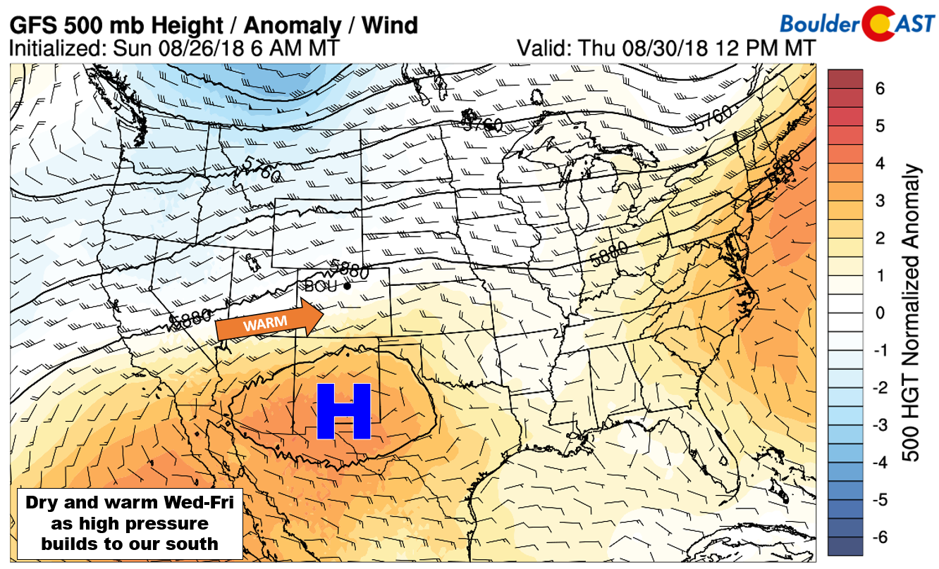
GFS 500 mb height anomaly forecast for Thursday.
We’re not seeing sufficient moisture to fuel any storm development any of these days. Depending on how the winds behave, we could see fire weather concerns creep up come Thursday or Friday (or over the weekend). As of now, though, things look okay. Temperatures will be in the lower 80’s to lower 90’s these days.
The upcoming holiday weekend looks similar across the Metro area with quiet conditions and temperatures near or slightly above normal. While Saturday will be dry statewide, models are showing the potential for significant wet weather across the Mountains Sunday into Monday. Confidence is low that far out. We’ll provide an update on the weekend forecast later in the week.
Forecast Specifics:
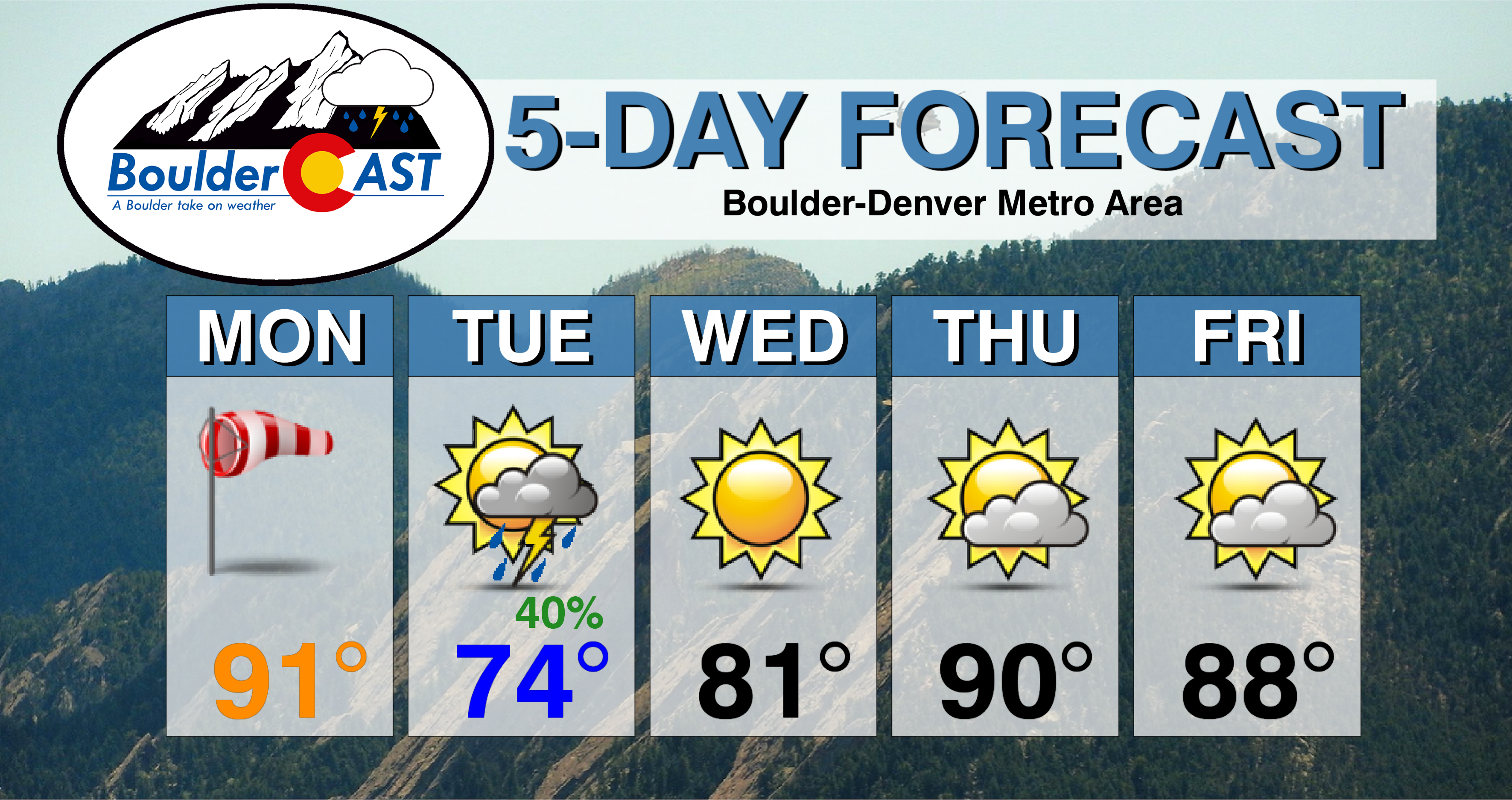
Monday: Hot, breezy and dry. A few morning wave clouds will give way to sunny skies. Winds gusting up to 30 mph through the day will create dangerous fire conditions region-wide. Highs near 90 degrees across the Plains and upper 70’s in the Foothills.
Tuesday: Much cooler with sunshine early. Increasing clouds and light smoke through the day are expected, with a chance of rain showers in the evening. Showers should be light and end before midnight. High temperatures in the middle 70’s for the Plains with middle 60’s in the Foothills.
Wednesday: Sunny and warmer. High temperatures in the lower 80’s across the Plains with upper 60’s in the Foothills.
Thursday: Morning sunshine, then mostly cloudy. Expect highs in the upper 80’s for the Plains and in the mid 70’s in the Foothills.
Friday: Partly sunny and warm. Look for highs in the upper 80’s for the Plains with middle 70’s in the Foothills.
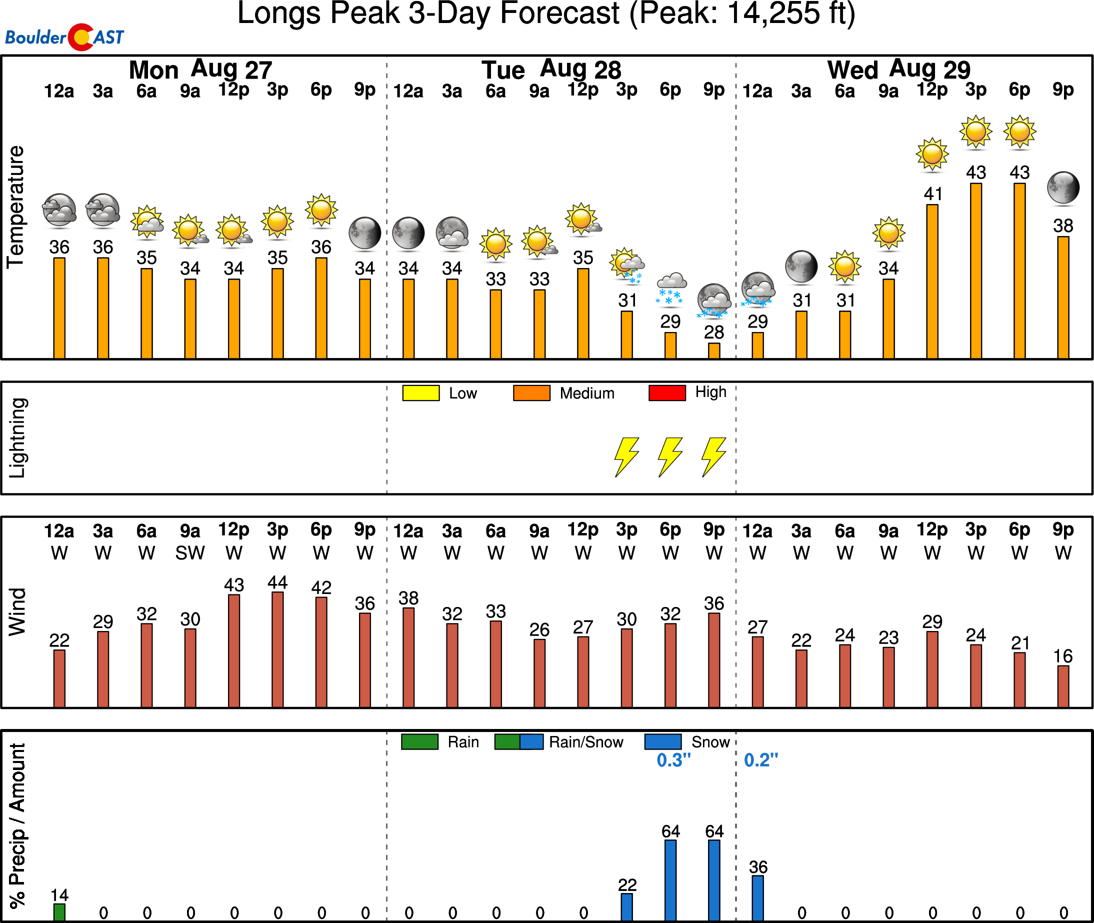
High Country: Following along with the lower elevations, it will be a relatively quiet week in the Mountains as well. Tuesday evening’s isolated showers and storms will be the only chance of precipitation for the week. Monday will be breezy, but warm. Otherwise, light to moderate winds and pleasant conditions will be around through Friday. Check out our SummitCAST page for 6-day forecasts for more than 120 Colorado mountain destinations!
DISCLAIMER: This weekly outlook forecast was created Monday morning and covers the entire upcoming week. Accuracy will decrease as the week progresses as this post is NOT updated. To receive daily updated forecasts, subscribe to BoulderCAST Premium.

.
Share our forecast!


You must be logged in to post a comment.