Not long ago, 2018 was in the running with 2012 for the hottest summer on record for many Front Range cities. However, a subtle but crucial pattern shift has kept our temperatures on the cool side for the last three weeks, knocking this summer back to a status closer to normal. We discuss this shift and provide an update on our summer forecasting contest which wraps up at the end of the month.
Why you gotta be so cold?
NOTE: In this post, we’re talking about meteorological summer which runs from June 1st to August 31st, not the actual summer season. Meteorological summer is the one that is used for weather related statistics and monitoring.
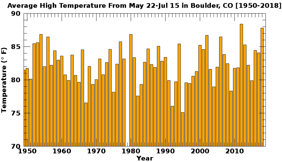
The period of May 22 though July 15, 2018 was the second warmest on record in Boulder. We showed this graph about one month ago:
During the month of June, a ridge was parked over New Mexico and Texas (below, top left). With eastern Colorado under the ridge axis, sinking/dry air made for warm and sunny conditions day after day, week after week for the Front Range (below, bottom left). This pattern would have been great for the monsoon had it stuck around a little longer…
Unfortunately, towards the middle of July, a mere days after monsoon season officially commenced, we started to see a small but important pattern change across the western United States. The pesky ridge migrated further westward into Nevada and California, and in the process switched the general flow into Colorado to be northwesterly (below, top right). Northwesterly flow is almost always cooler than southwesterly. This direction also opens the door for backdoor cold fronts to seep into the Metro area from the High Plains region. You can see the stark change in northeast Colorado’s temperature ranking for July 2018 (below bottom right) compared to June 2018 (below, bottom left). The most intense heat followed the ridge westward.

There were two other consequences of this large-scale shift…
(1) Monsoon Season? What Monsoon Season? The shift in the location of the high pressure put a big, fat wrench into monsoon season for much of Colorado. The ideal pattern for moisture to flow into our state is the exact one that we had in June…southwesterly and directly from Arizona. June was too early, though. The moisture wasn’t there yet. The monsoon is slow to materialize and rarely begins earlier than July 1st. As a result, Colorado saw only meager and sporadic monsoon moisture this year. Eastern Colorado made out okay (thanks to consequence #2 below), but western Colorado has truly missed out on the moisture and has continued to wither as a result. Grand Junction, for example, has only received 0.22″ of rain this entire summer, their driest on record.
It’s been feast or famine for rainfall this summer across the Metro area. Anywhere from 2 to 12 inches of rain has been recorded. Localized heavy rainfall from passing thunderstorms led to large variations over relatively small distances. Here are some of the rain totals since June 1st:
- Boulder (official): 4.83″
- BoulderCAST Station: 2.66″
- Denver International Airport: 1.92″
- Fort Lupton: 5.73″
Front Range rainfall totals since June 1, 2018.
Most of the Front Range has had between 4 and 7″ of rain this summer, which is more or less on-par with average.
(2) Extended Severe Weather Season: Those backdoor cold fronts combined with the northwest flow to provide the moisture and shear to fuel frequent severe thunderstorms during the month of July. Peak severe weather season for eastern Colorado tends to be late May and the first half of June (see below). This year, severe weather did not let up much in the month of July. In fact, there was a nine day streak with at least one severe weather report in eastern Colorado, July 21st to 29th. I can’t recall a month of July with multiple tornado chase days. In what is typically a quiet month for weather forecasting here, things sure stayed busy!
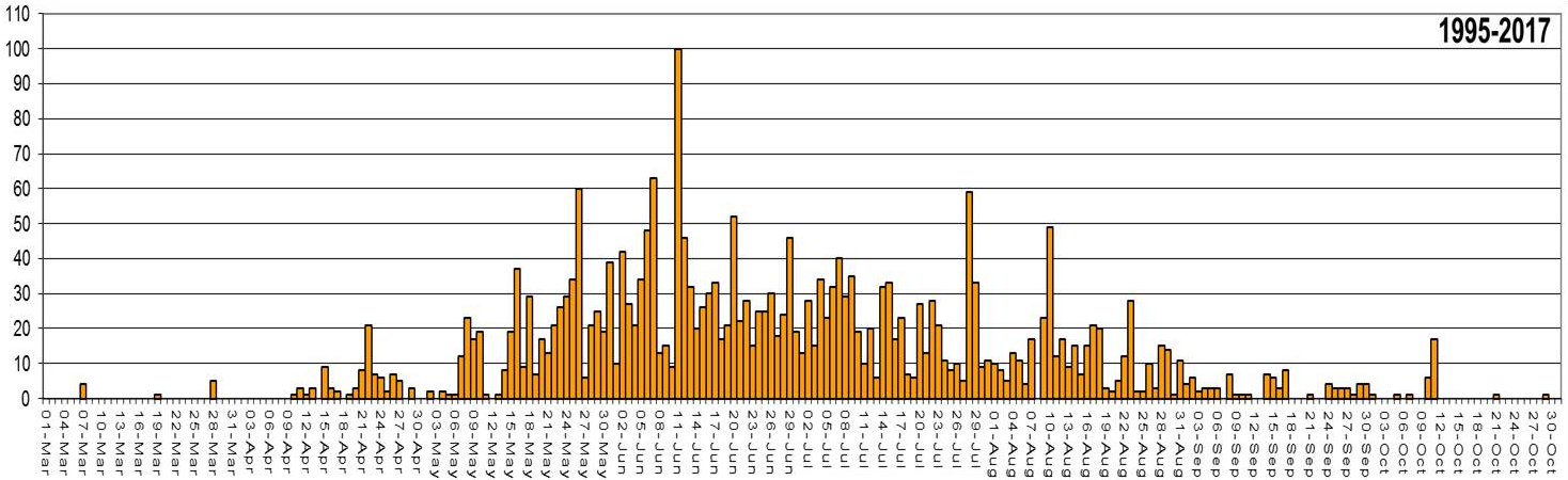
Total number of severe weather reports by day for eastern Colorado (1995-2017). Source: NWS Pueblo.
Here’s a look at daily temperature departures from normal since June 1st in Boulder. Notice how the extreme warmth of June transitioned to a cooler pattern in July. There was even a stretch of 11 consecutive days with below normal temperatures.
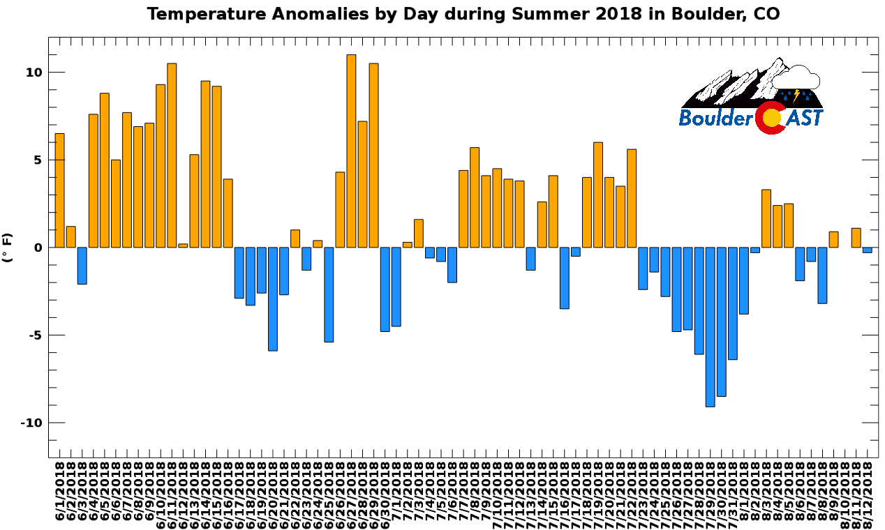
We should also mention that the cool-down has not been felt in any way for western Colorado. Back-door cold fronts do not have the oomph to make it west of the Continental Divide. Grand Junction is currently riding a streak of 53 consecutive 90-degree days, and has only seen below normal temperatures 3 times this entire summer. Try not to brag about the cooler Denver weather to your Western Slope friends!
As a result of this pattern change, Summer 2018 is no longer in the running for historical warmth for us. Sure, it will likely conclude above average, but nothing like it could have been if the heat of June and early July persisted all summer long… Looking ahead, temperatures will continue to hover near or slightly above average until this weekend when a stronger Pacific trough is progged to move across the state. Saturday is shaping up to be a wet and stormy day for our region. Severe storms and localized flooding are looking more likely for eastern Colorado.
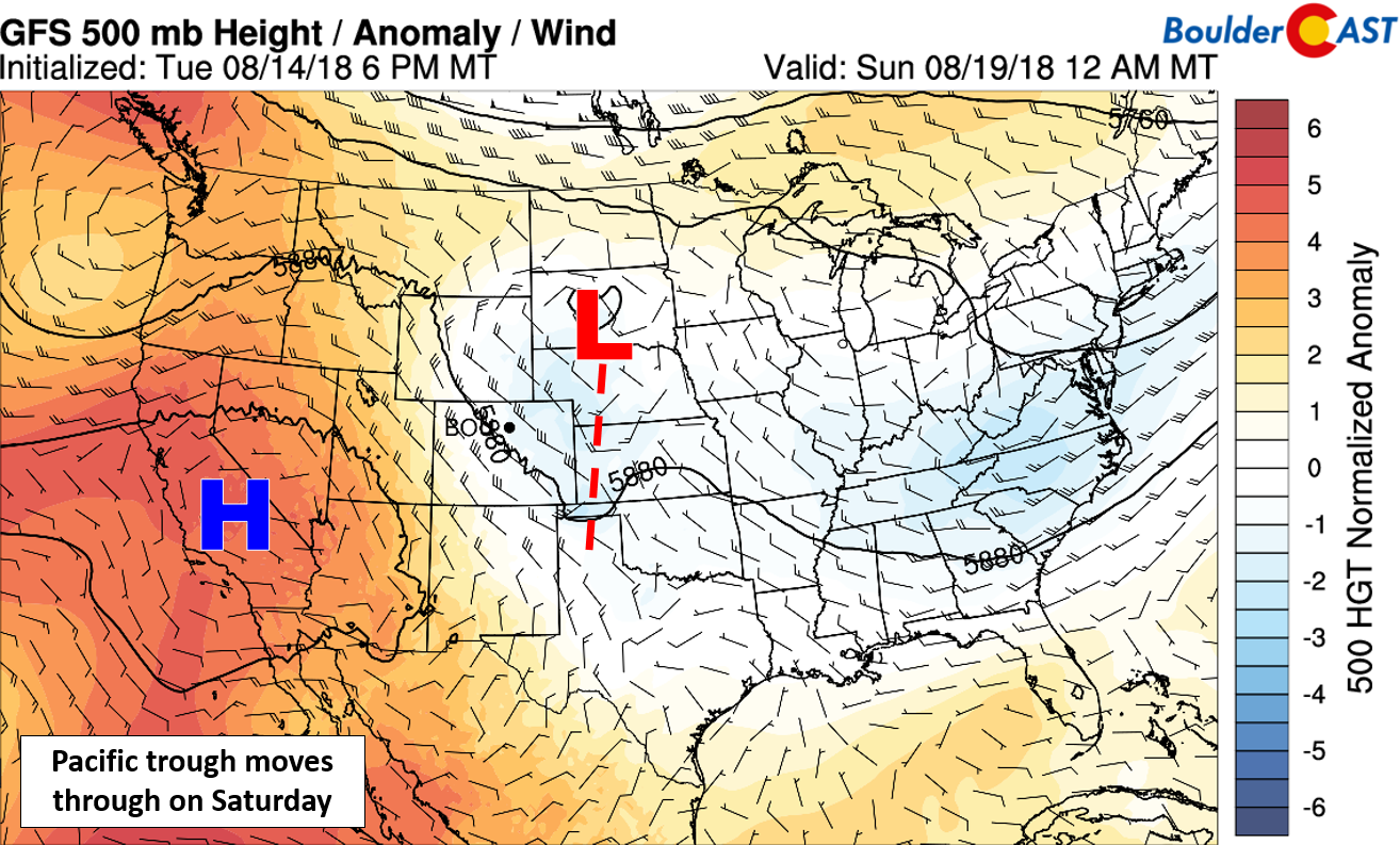
GFS 500 mb height anomaly forecast for Saturday night. This pattern looks familiar, doesn’t it?
Some models are hinting that temperatures could fall into the 70’s Sunday and early next week. We’re not counting our chickens yet on this one….models still have stark disagreements on the general weather pattern, which is always a red flag. Notice the large spread in GFS ensemble members below for these days. Take advantage of the warmth while you can, our first snow could be less than one month away!
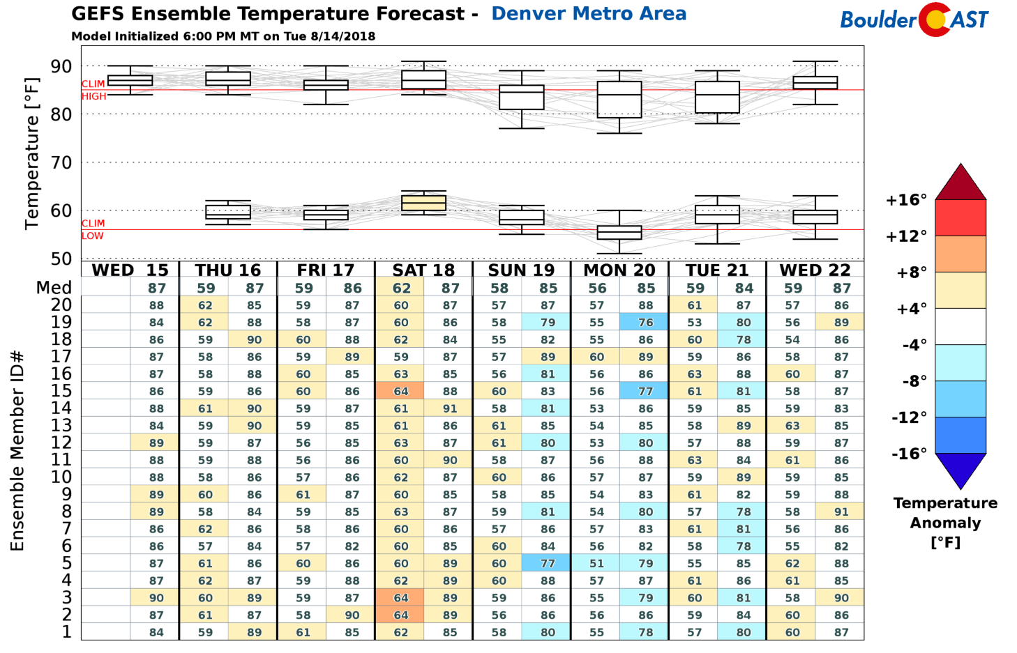
GFS ensemble temperature forecast for the Denver Metro area through the middle of next week.
Summer Heat Forecast Contest Update (Finally!)
Our most recent forecast contest related to predicting the “Summer Heat” has been running since June 1st and will conclude at the end of August. Here’s the short version of the contest announcement details….
Contest info
PRIMARY FORECAST: How many 90+ degree days will Boulder see between June 1 and August 31?
FIRST TIE-BREAKER: What will be the warmest temperature recorded in Boulder between June 1 and August 31?
SECOND TIE-BREAKER: What will be the longest streak of 90+ degree days in Boulder between June 1 and August 31?
For forecast verification, we use the official Boulder climate station located at the NIST building in south Boulder.
Prizes
- First Place: $50 Amazon Gift Card & 6-month subscription to Premium
- Second Place: 6-month subscription to Premium
- Third-Place: 3-month subscription to Premium
- Anyone Who Guesses Any Two Forecasts Exactly Correct: 3-month subscription to Premium
- Anyone Who Guesses Any One Forecast Exactly Correct: 1-month subscription to Premium
Status as of August 14th
Through August 14th…here are the current numbers…
- 90-degree days: 32
- Hottest temperature: 98 degrees
- Longest 90+ day streak: 6 days
With the HOT start to the summer, more than half of the 117 participants have already been eliminated from first-place contention. Keep in mind that even if you are eliminated, you are probably still in the running for “exact guess” prizes. Below is a break down of all the entries. Kirsten P. from Arvada is the current leader. This, however will change as additional 90-degree days occur throughout the rest of August (will they though?).
We’ll announce the winners and distribute prizes in early September! Good luck….
https://docs.google.com/spreadsheets/d/1X7AVjjLKQAfyxpEI1GvJN4nOqkrZipzP8RS72JUJZ2I/edit?usp=sharing
Visit the Official Contest Page for color-coding and a better look at where you currently stand in the contest.
.
Share this post:
.


You must be logged in to post a comment.