September is finally upon us — what a great time of the year this is in Colorado! Mother Nature will deliver rather varied weather this week in the Front Range. Hot temperatures and high pressure will give way to a Pacific trough by midweek. Clouds will be on the increase alongside the risk of severe thunderstorms for Wednesday, with even a touch of snow in our highest elevations. Things will clear out nicely for the upcoming weekend leading to gorgeous and seasonal late-summer conditions. Read on for all the details.
This week’s highlights include:
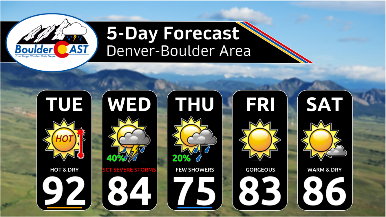
- Toasty Tuesday: One last hot and dry day with highs in the lower 90s under high pressure.
- A Stormy Wednesday: A Pacific trough will move through the area with our best chance of rain for the week, including a small risk for severe storms.
- Autumn Feels on Thursday: In the wake of trough, Thursday will see much cooler temperatures in the 70s for highs with a few showers possible.
- Dry & Warm for the Weekend: High pressure rebuilds across the area with a slow warming trend taking us back into the 80s for the weekend.
- Drought Update: Limited rainfall chances this week and the likelihood of a warm and dry autumn ahead don’t bode well for our area’s ongoing severe drought.
DISCLAIMER: This weekly outlook forecast is created Monday morning and covers the entire upcoming week. Accuracy will decrease as the week progresses as this post is NOT updated. To receive daily updated forecasts from our team, among many other perks, subscribe to BoulderCAST Premium.

Go Premium, get all the perks.
Daily Forecast Updates
Get our daily forecast discussion every morning delivered to your inbox.
All Our Model Data
Access to all our Colorado-centric high-resolution weather model graphics. Seriously — every one!
Ski & Hiking Forecasts
6-day forecasts for all the Colorado ski resorts, plus more than 120 hiking trails, including every 14er.
Smoke Forecasts
Wildfire smoke concentration predictions up to 72 hours into the future.
Exclusive Content
Weekend outlooks every Thursday, bonus storm updates, historical data and much more!
No Advertisements
Enjoy ad-free viewing on the entire site.
Up and down temps with one shot at rain this week
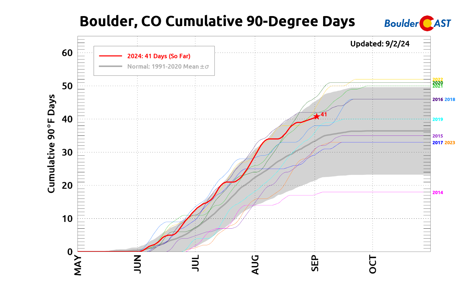
Labor Day Monday was Boulder’s 41st 90-degree day of the year as we briefly touched the threshold around 5PM. This summer has definitely been on the hotter side, with an average year only producing a total of 36 90-degree days for us — we surpassed that count weeks ago. The good news is that after September 3rd, there is typically only another two or three days of 90-degree heat. The bads news is that one of those historically-supported toasty days will happen early this week!
The first full week of September will begin under the influence of a lingering high pressure system, the same one which backstopped our beautiful weather during the elongated Labor Day Weekend. As of Tuesday morning, the aforementioned high pressure stretches from southern California into the Upper Midwest — but most importantly, directly across the Denver area. This ridge is in the process of being “flattened out” by an approaching low pressure trough from the Pacific Northwest.
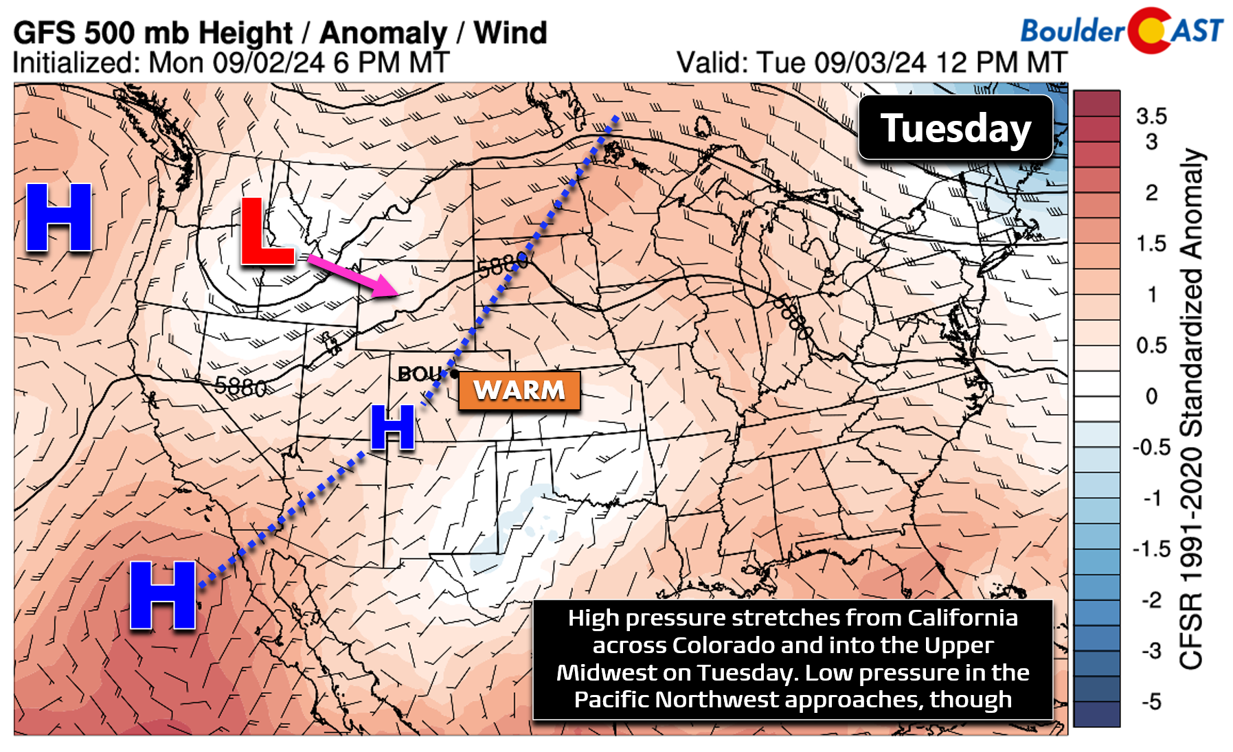
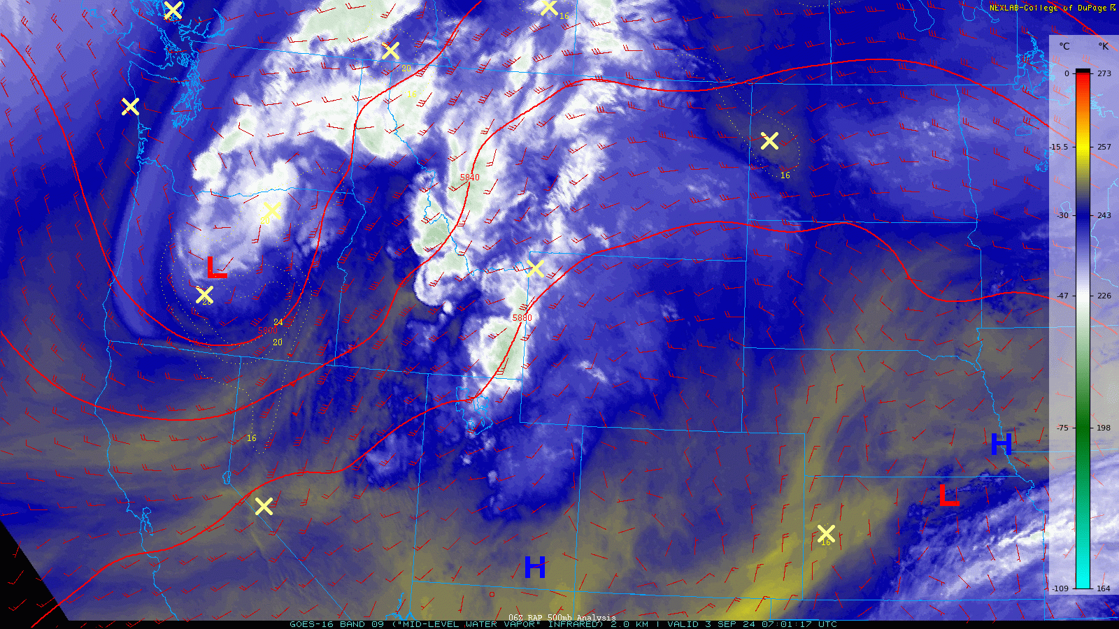
This trough is visible on Tuesday’s GOES-East water vapor satellite animation below, spinning currently across portions of eastern Oregon. Closer to home, weak high pressure is situated over the Four Corners area, with dry and warm air present across the Front Range under light west-northwest flow.
This setup will support one more very warm and dry day in the Front Range on Tuesday. High temperatures will push into the lower 90s for most with partly cloudy late-day skies. Similar to Monday, there’s a slight chance for one or two isolated thunderstorms Tuesday afternoon and evening, but those should remain only across the higher terrain.
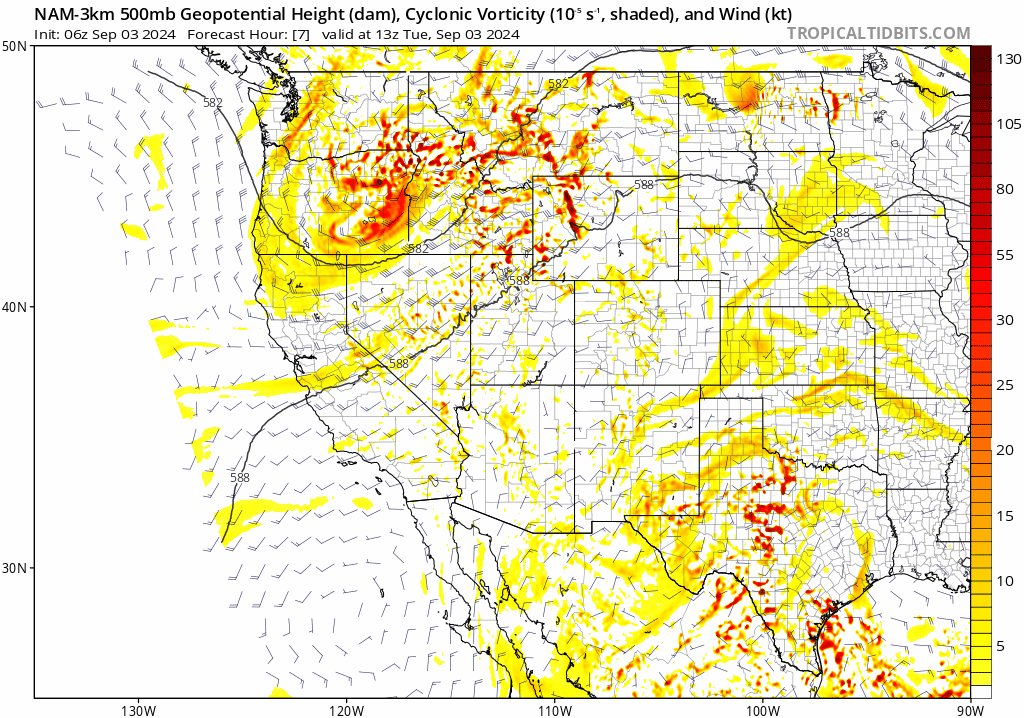
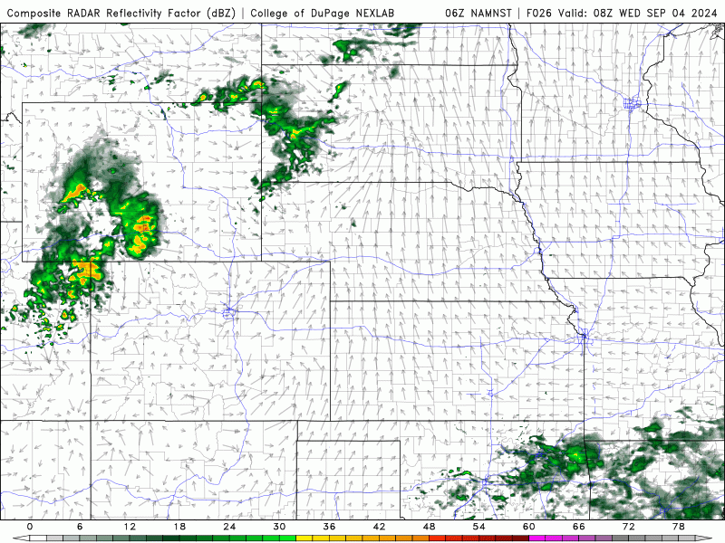
As we move into Wednesday, the main weather-maker for the week will slowly approach Colorado from the northwest bringing with it increased moisture and synoptic-scale lift to support scattered showers and thunderstorms — our best chance of picking up any rainfall this week. The 500mb vorticity forecast animation below shows the evolution of the trough through Thursday morning. The best energy is expected to stay just north and east of our area, but we will definitely still receive a solid glancing blow, if there is such a thing.
This trough appears to be well-time with peak daytime heating, allowing for a round of scattered showers and thunderstorms to develop over our area as it passes with enhanced lift for storms. Wednesday will be partly to mostly cloudy across the area with about 40% chances for thunderstorms — the focus is on the mid-afternoon into the mid-evening. High temperatures on Wednesday will be cooler as a result of the rain and clouds, only reaching the lower to middle 80s. There will also be a weak pre-dawn cold front aiding to make Wednesday 5 to 10°F cooler than Tuesday.
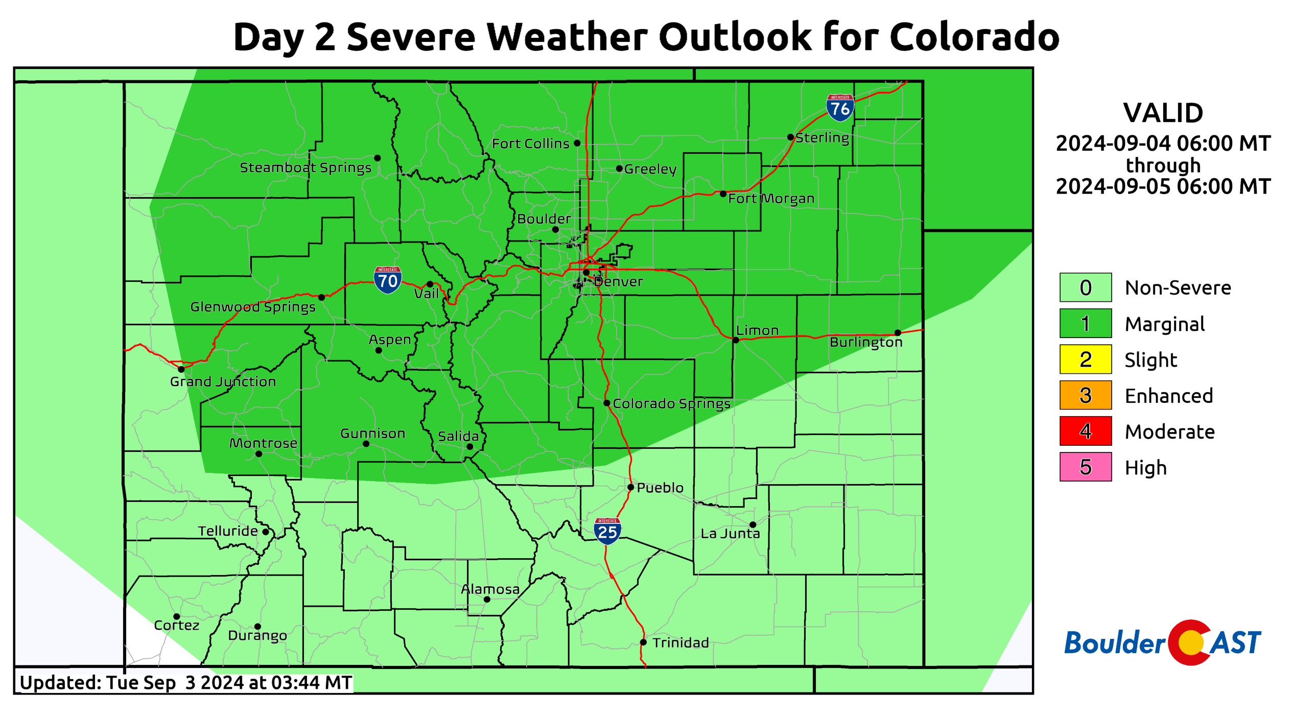
The Storm Prediction Center currently paints much of northern Colorado at Marginal risk for severe storms on Wednesday when decent amounts of moisture, lift and shear will all overlap. We’re not expecting a widespread, significant outbreak of severe weather, but a couple storms late-day Wednesday may contain 1″ hail and 60 MPH wind gusts. This is most likely to happen along and south of Interstate 70 across the Mountains, Palmer Divide and adjacent Plains towards Limon. Still 36 hours away, things could shift slightly so keep an eye on the forecast for the second half of Wednesday — Boulder and Denver are definitely in the mix still!
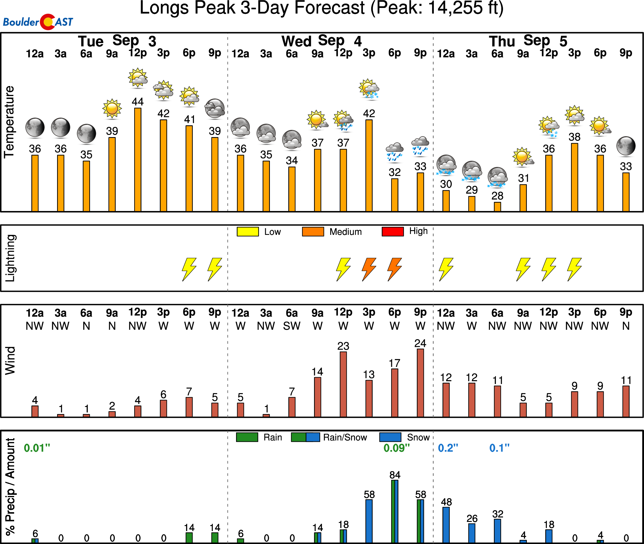
This is the first week of September after all with meteorological autumn beginning this past Sunday. While it sure still feels like summer, the seasons are indeed changing with the nights growing longer and cooler, and the heat of the day starting to become notably less intense. Thanks to the shifting seasons, we will usually have to discuss snow with most passing storm systems from this point onwards. Wednesday’s trough will indeed have a little bit of the white stuff, but only for the highest elevations. The most prominent mountains in the state could see a light dusting of snow Wednesday night, including atop Longs Peak in Boulder County:
The primary cold front associated with the trough will pass through the Denver area late on Wednesday paving the way for a cooler end to the week. Lingering low clouds and showers may be around Thursday morning, but as the day wears on, skies should clear out somewhat allowing for the redevelopment of a few thunderstorms, mainly over the higher terrain. The chance of rain on Thursday is 20% alongside our coolest temperatures of the week with highs in the middle 70s.
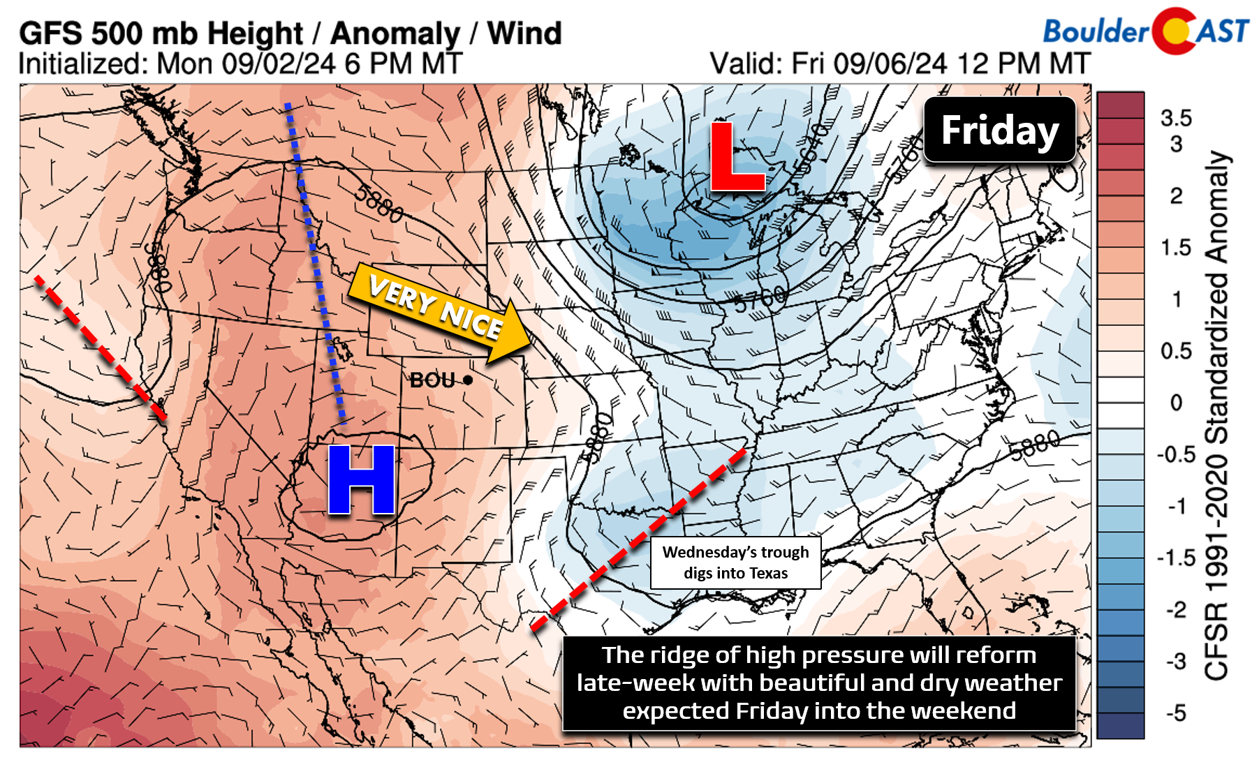
By Friday, things will quiet down considerably as the pesky mid-week trough will be long-gone into Texas (shown below). The same ridge of high pressure from early in the week will regain its foothold across the West by Friday morning with dry west-northwest flow pushing into Colorado. This will create a beautiful end to the week in the Front Range with highs in the low to middle 80s Friday and Saturday with plenty of sunshine.
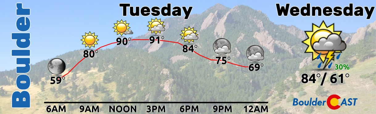
Our extended forecast graphic below shows that temperatures will be up and down this week with Tuesday feeling like summer in the 90s, but Thursday giving us a taste of autumn in the 70s. As mentioned, our main chance of rain comes on Wednesday with perhaps a few lingering showers into Thursday. The upcoming weekend’s weather will be excellent.
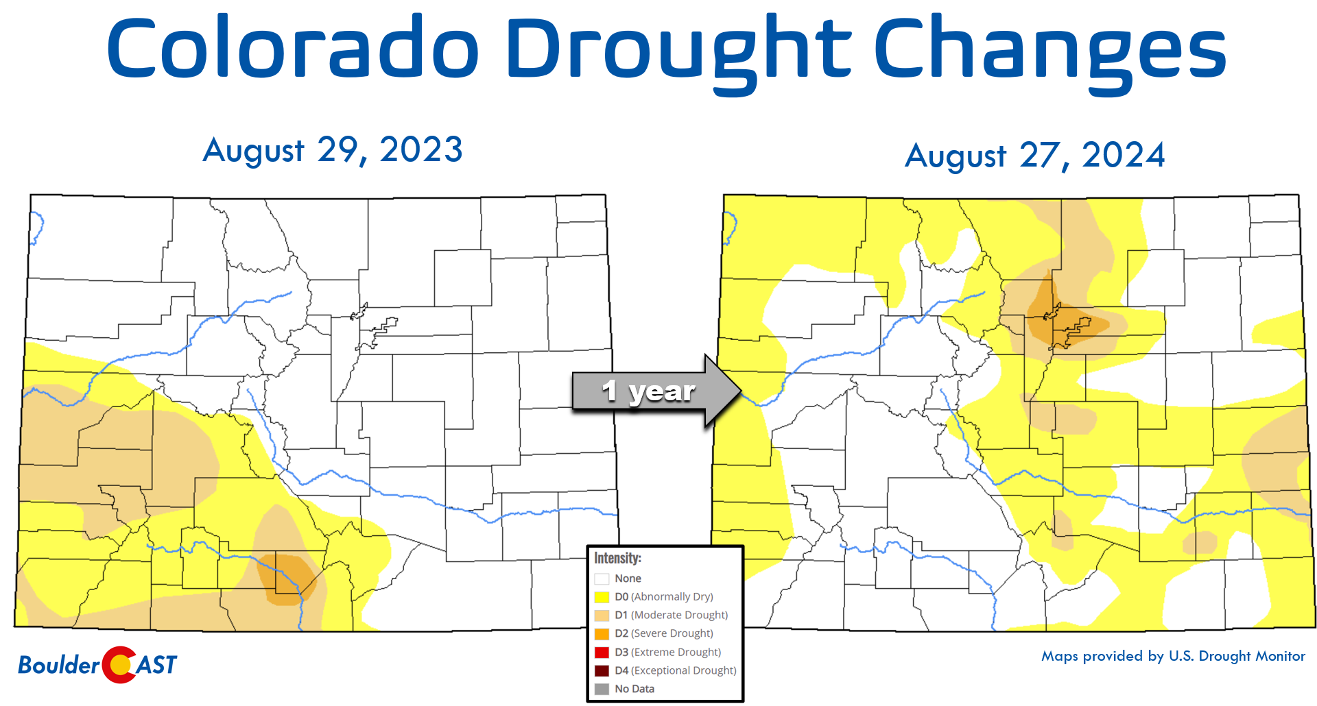
Unfortunately this week’s mostly dry conditions will help little with the ongoing drought in the Front Range. Though we had some wetter monsoon weather in August (finally!), much of our vegetation is still primed for wildfire growth in the Foothills and Metro area alike. Things are definitely better than they were a month ago, don’t underestimate how much the recent rains have helped, but we’re still in a rough spot heading into autumn. The graphic below highlights the flip-flopped drought situation in Colorado compared to one year ago.
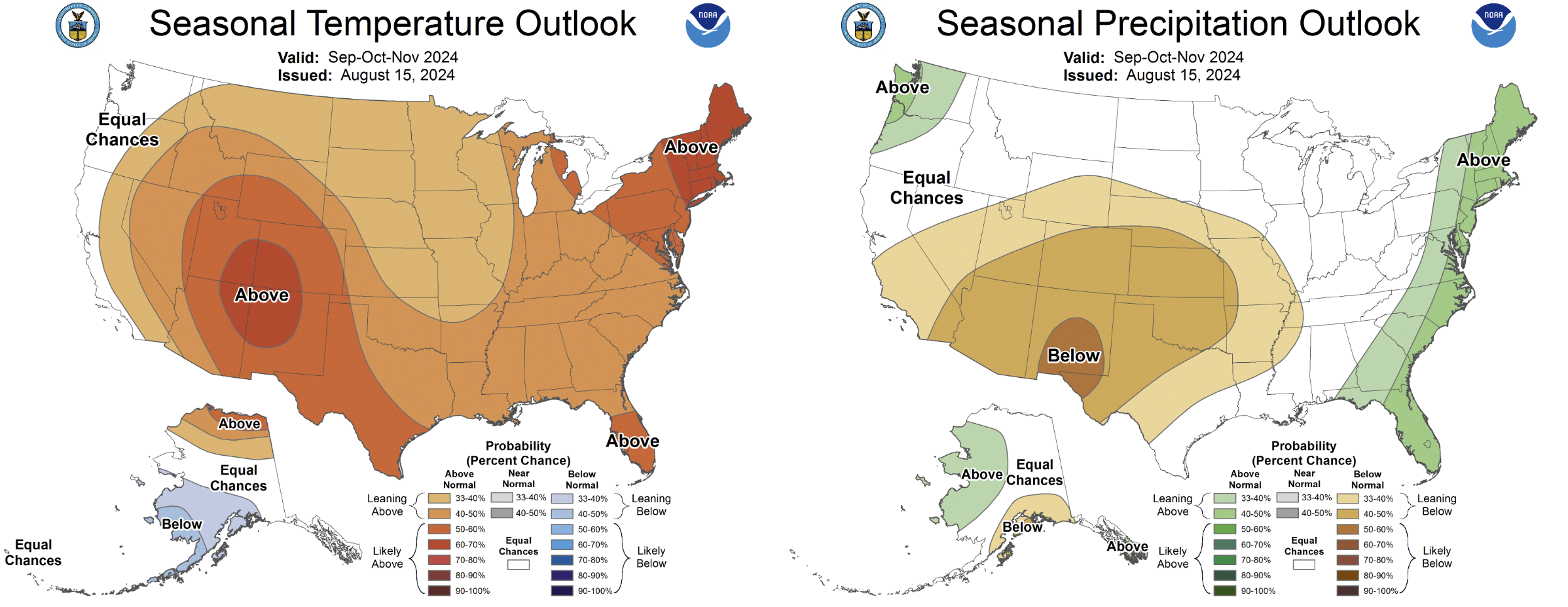
The outlook for the next three months is for a dry and warm autumn in all of Colorado. If the rain and snow don’t come soon, autumn’s stronger winds and the fire danger they create certainty will…
Forecast Specifics:
Tuesday: Morning sunshine giving way to partly cloudy skies later in the day with a slight chance of an isolated thundershowers, almost exclusively in the higher terrain. High temperatures will be hot reaching the lower 90s on the Plains with upper 70s in the Foothills.
Wednesday: Partly cloudy and somewhat cooler with scattered showers and thunderstorms around, mainly in the afternoon and evening (but some possible in AM as well). A few storms may produce severe hail and wind. High temperatures in the low to middle 80s on the Plains with upper 60s in the Foothills.
Thursday: Lingering morning clouds and isolated rain showers, but things will dry out through the day with partly cloudy skies. A couple storms may bubble up in the afternoon instability, mainly in the Foothills. High temperatures will remain cool in the middle 70s on the Plains with lower 60s in the Foothills.
Friday: Very pleasant under sunny skies and cool conditions. Temperatures will top out near seasonal normals in the low to middle 80s on the Plains and in the lower 70s in the Foothills.
Weekend: Temperatures will stay in the 80s with mostly dry weather expected in the Metro area.
Get BoulderCAST updates delivered to your inbox:
DISCLAIMER: This weekly outlook forecast is created Monday morning and covers the entire upcoming week. Accuracy will decrease as the week progresses as this post is NOT updated. To receive daily updated forecasts from our team, among many other perks, subscribe to BoulderCAST Premium.
Go Premium, get all the perks.
Daily Forecast Updates
Get our daily forecast discussion every morning delivered to your inbox.
All Our Model Data
Access to all our Colorado-centric high-resolution weather model graphics. Seriously — every one!
Ski & Hiking Forecasts
6-day forecasts for all the Colorado ski resorts, plus more than 120 hiking trails, including every 14er.
Smoke Forecasts
Wildfire smoke concentration predictions up to 72 hours into the future.
Exclusive Content
Weekend outlooks every Thursday, bonus storm updates, historical data and much more!
No Advertisements
Enjoy ad-free viewing on the entire site.
Enjoy our content? Give it a share!


You must be logged in to post a comment.