All is quiet to kick off the week in the Front Range with high pressure in place across the Rockies. Temperatures will start out close to 80 degrees Monday and Tuesday but that won’t last long. All eyes are on a potent autumn storm system moving in from the Pacific Northwest later this week. Model uncertainty is somewhat high in regards to the storm’s track, but consensus currently would indicate a decent chance of rain in the Denver Metro area with snow possible along the Wyoming border and in our nearby Mountains. Things could certainly change as we get closer though. Either way, it will be a colder end to the week with the first freeze of the season possible Friday and/or Saturday mornings.
This week’s highlights include:
- High pressure ridging and surface lee troughing will produce mild and quiet weather for the Front Range into most of Wednesday
- Highs start out close to 80 degrees to begin the work week, well above normal for this time of year
- We are closely watching a potent area of low pressure poised to impact the region later in the week
- Model consensus shows the storm will track just a tad too far north, but it bears watching
- Snow increasingly favored for the High Country later this week and for areas along the Wyoming/Nebraska borders — Denver area should see mostly or exclusively rain
DISCLAIMER: This weekly outlook forecast is created Monday morning and covers the entire upcoming week. Accuracy will decrease as the week progresses as this post is NOT updated. To receive daily updated forecasts from our team, among many other perks, subscribe to BoulderCAST Premium.

Go Premium, get all the perks.
Daily Forecast Updates
Get our daily forecast discussion every morning delivered to your inbox.
All Our Model Data
Access to all our Colorado-centric high-resolution weather model graphics. Seriously — every one!
Ski & Hiking Forecasts
6-day forecasts for all the Colorado ski resorts, plus more than 120 hiking trails, including every 14er.
Smoke Forecasts
Wildfire smoke concentration predictions up to 72 hours into the future.
Exclusive Content
Weekend outlooks every Thursday, bonus storm updates, historical data and much more!
No Advertisements
Enjoy ad-free viewing on the entire site.
Quiet & mild to start
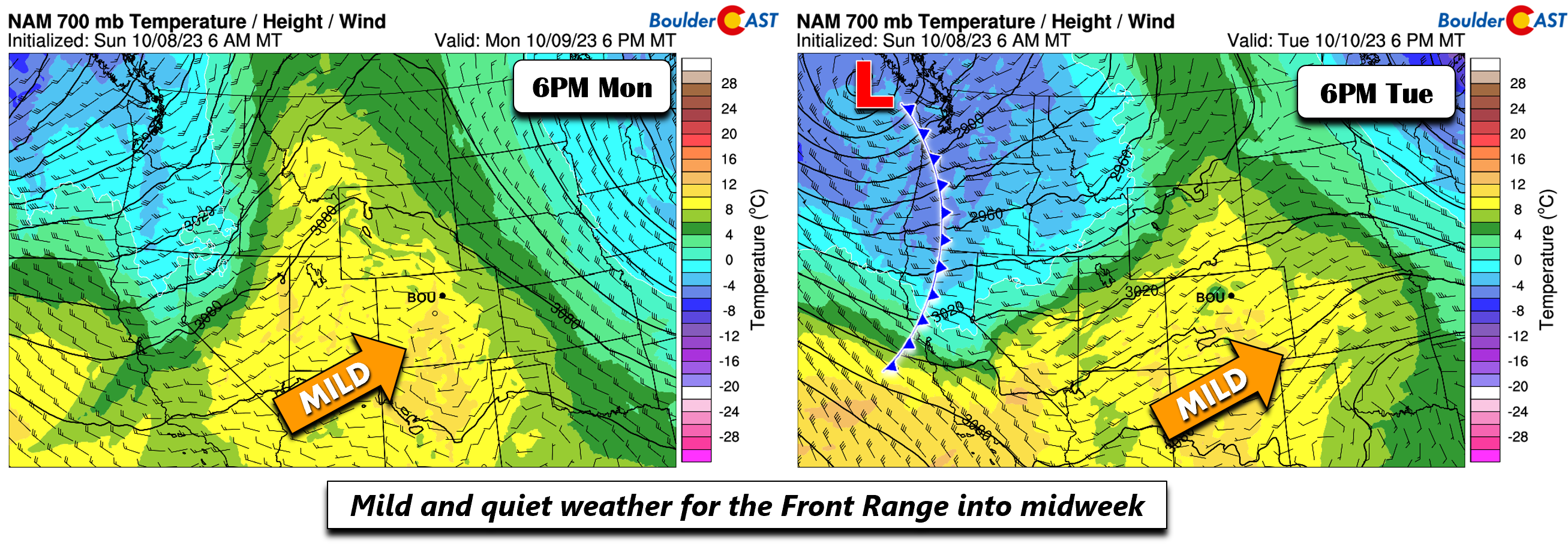
All is quiet to start our our second work week of October. Our average highs this week are in the upper 60s, but we will be somewhat mild relative to these normals. The reason? A mid-level ridge will exist over the Intermountain West into midweek. Come Wednesday, zonal flow will start to take over in advance of a stronger system moving in from the northwest. To the east, chillier air is in place beneath a deep trough extending from the Great Lakes southward even into Florida — so there’s quite a stark contrast across the nation to start the week.
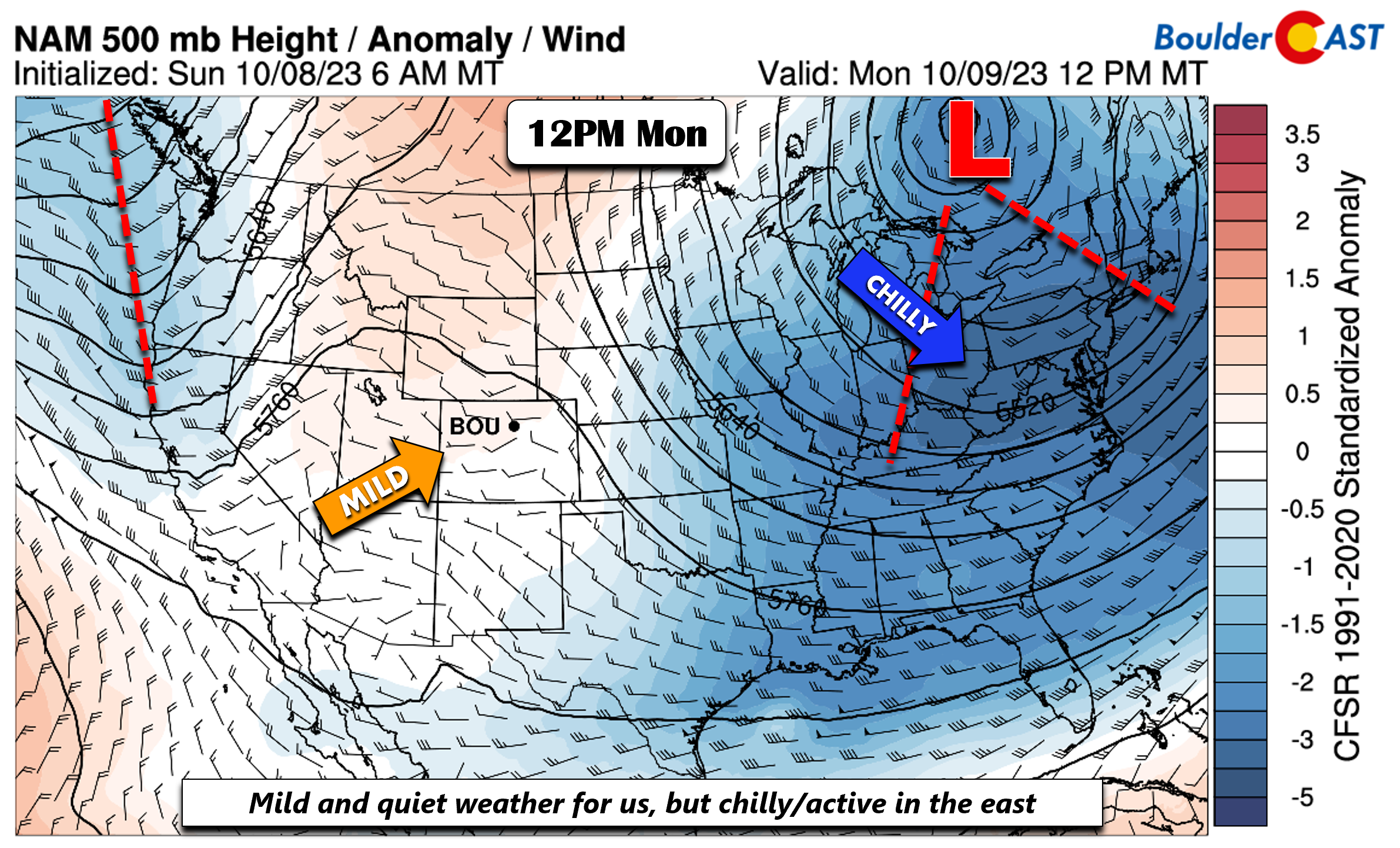
The surface pattern corresponding to the ridge these next few days will feature westerly downslope warming across eastern Colorado. The result will be a mixture of clouds and sunshine with highs in the upper 70s.
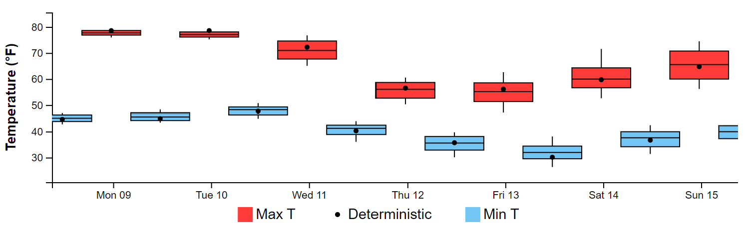
A look at the entire week in regards to highs and lows is shown below using the National Blend of Models (NBM) from the NWS for Denver. Note the mild temperatures to start the week. The bottom falls out come Thursday and Friday with a strong cold front and area of low pressure, which we will get to in just a minute. Note also that overnight low temperatures Friday and Saturday morning, which could dip below freezing across the Plains.
Watching a strong trough mid-late week…wintry precipitation?
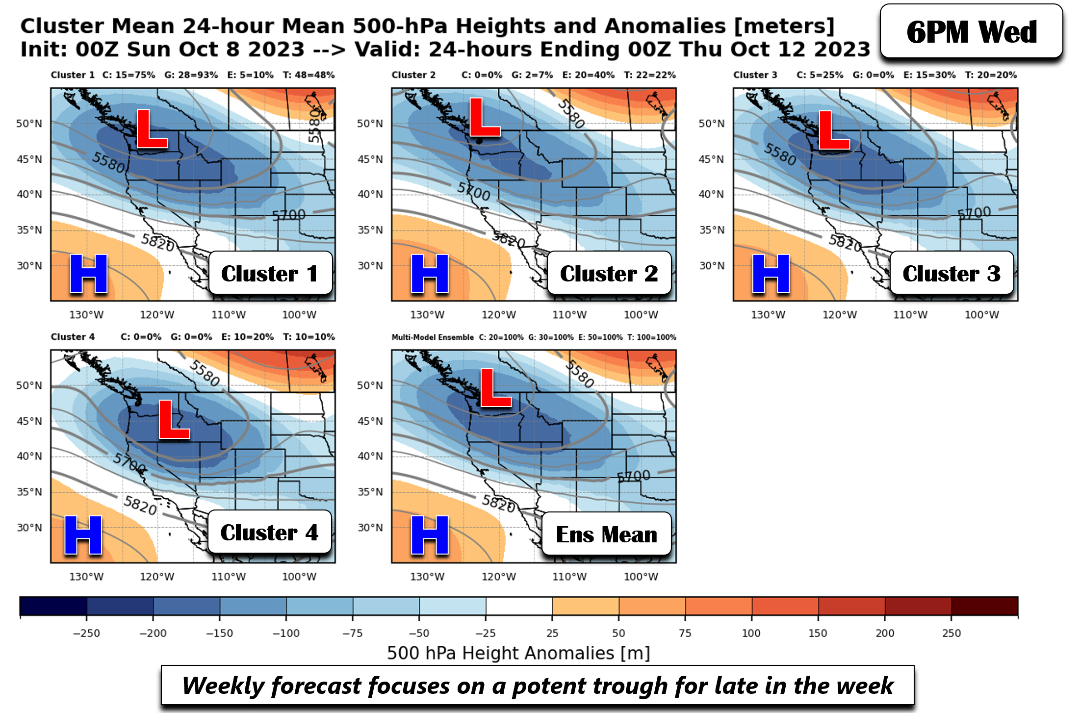
While the start of our week will be very quiet, the latter part will be far from it! We have been and still are watching a potent storm system taking aim on the Rockies and central Plains come Thursday into Friday. Model consensus is showing some consistency in the track of the storm, but spread still exists 3.5 days out. To delve into these uncertainties, let’s take a look at some ensemble cluster solutions, which take into account 100 members from the CMC, ECMWF, and GEFS. Each cluster represents a percentage of variability in the storm track/location. The pattern below is for 500-mb heights on Wednesday night. Most ensemble clusters, including the ensemble mean, show the trough will be over the Pacific Northwest, with the trough axis extending into the northern Rockies. Zonal flow will be over the Plains of Colorado at this time with likely increasing clouds and somewhat cooler temperatures in the lower to mid 70s — still a tad above normal for this time of year.
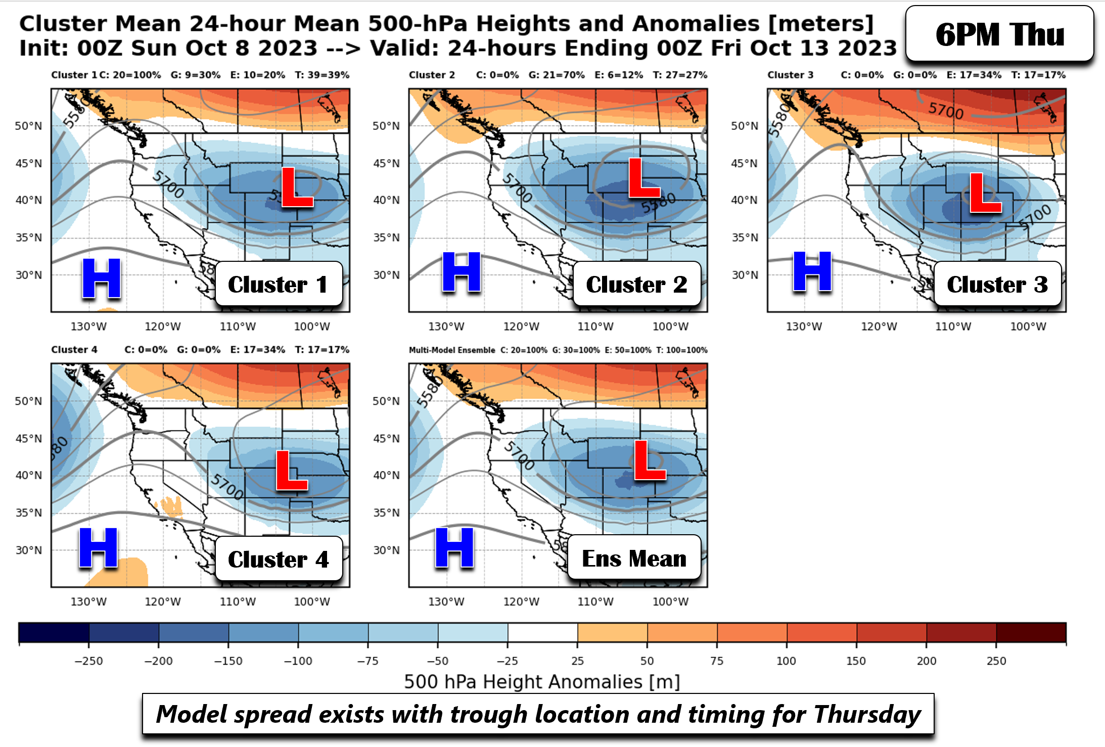
Ensemble spread is a tad larger by Thursday night, though there are not major differences in the spread of the low. The first two cluster solutions show the low pressure near the Wyoming/Colorado border, largely represented by the CMC/GEFS ensembles and 30% of the European ensemble data. The 3rd and 4th cluster solutions are entirely represented by the ECMWF, covering about 60% of the variance. The CMC/GEFS show a more northward position of the storm, while the Euro members are a tad south and slower in the movement. The deviation is not large though, with the ensemble mean still not in the most favorable position for snow in Denver.
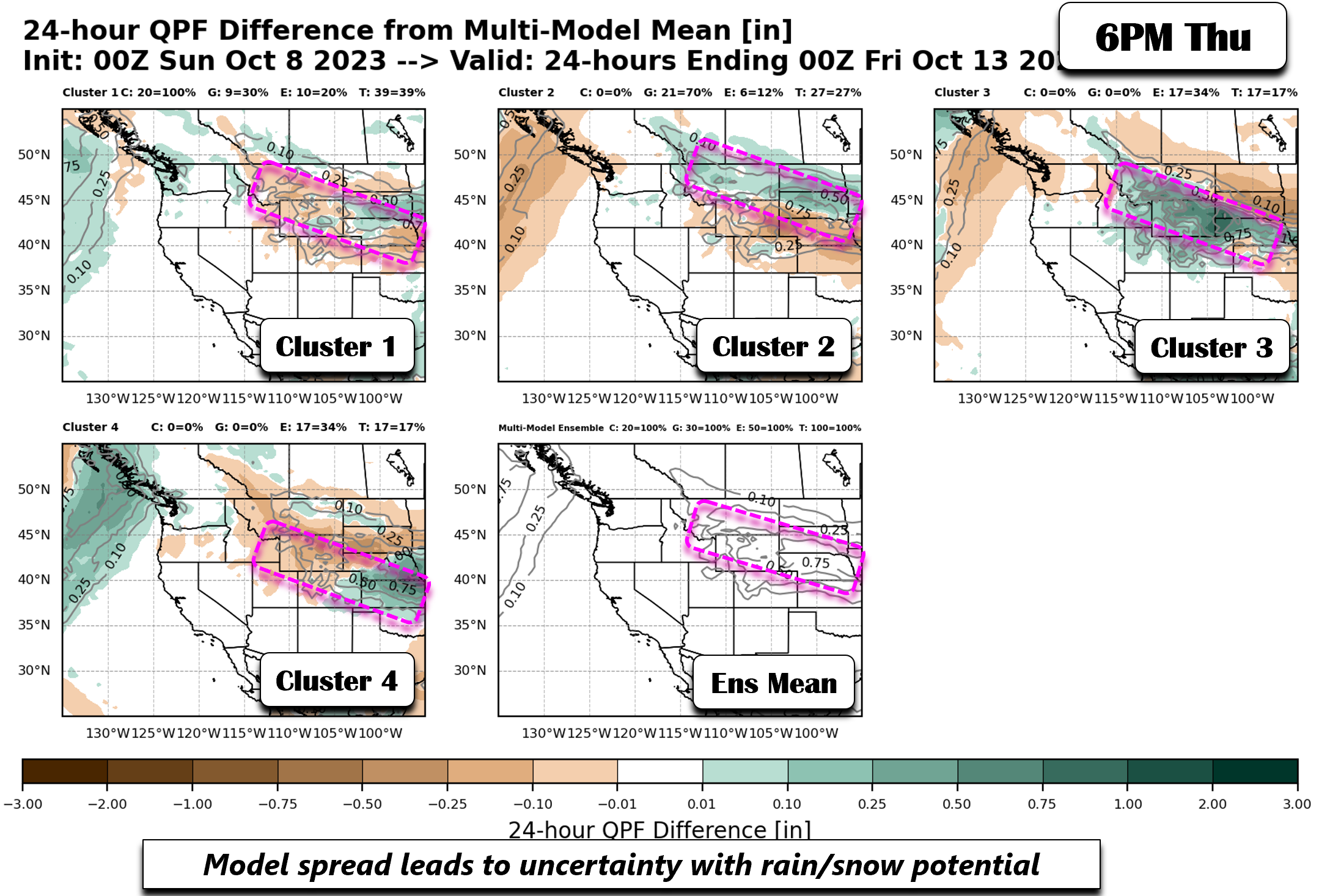
Corresponding to the above figure is the QPF (quantitive precipitation forecast) anomalies relative to the ensemble mean. In this figure, it can become more clear how the small shift in the track may impact QPF and potential snow. The first two clusters, not surprisingly with the more northern track, have higher QPF shifted over Wyoming and the Dakotas as mostly downslope flow exists over the Front Range. The third and fourth clusters, being a tad further south in the track of the low, shifts the QPF shield a touch south near the northern sections of the Front Range and especially along the Wyoming border as a tail-end period of upslope ensues in the colder air behind a cold front.
As it stands now, the probability of snow in Denver and Boulder with the current model trends, is fairly low, about 5% based on NBM guidance. However, this storm bears watching as a small shift could drastically change the forecast. The best chance of any snow would only be behind the storm as it tracks toward the Plains (late Thursday into early Friday), when a short period of upslope behind the storm could favor some light rain/snow potential. But again, probabilities are still too low to bear any confidence this far out. Regardless, it will be colder to end the week. Highs are projected to be in the 50s on Friday, but could be colder if a more southern track ultimately occurs.
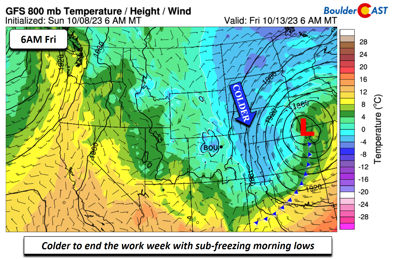
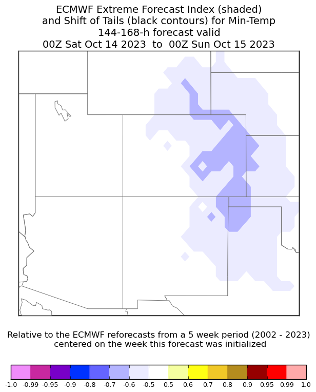
There is more confidence that low temperatures Friday and Saturday morning are favored to dip near or below freezing. With high pressure building in late this week and clear skies taking over with cold air entrenched, sub-freezing temperatures would be expected Saturday morning.
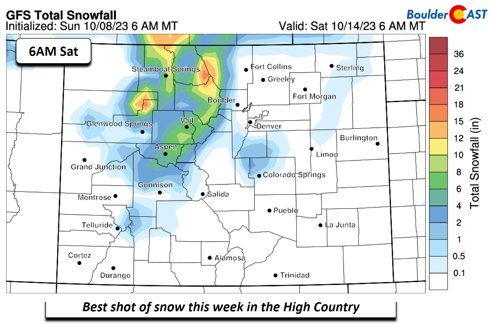
The best chance of snow will be in the High Country Wednesday into Friday. The GFS model would suggest some places could see a foot of snow by the morning hours of Saturday — the first widespread dumping of snow in our Mountains since early June!
Enjoy the wide gamut of weather this week and think snow!
Forecast Specifics:
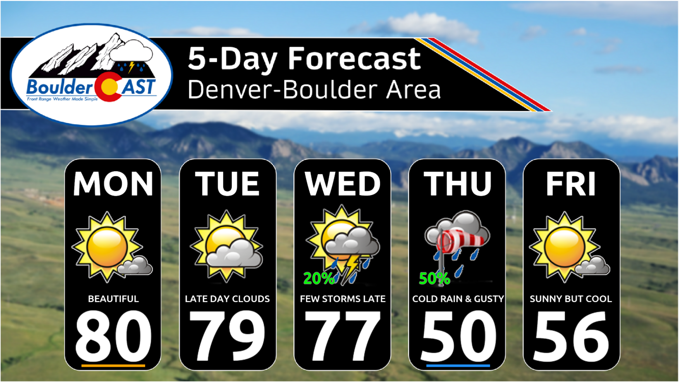
Monday: Mostly sunny and mild with temperatures nearing 80 degrees on the Plains and upper 60s in the Foothills.
Tuesday: Sun early with clouds increasing later in the day. Look for highs in the upper 70s for the Plains and upper 60s over the Foothills.
Wednesday: Increasing clouds with a chance of thunderstorms and rain late, especially Wednesday evening into the overnight. Highs in the middle 70s on the Plains and middle 60s in the Foothills.
Thursday: Mostly cloudy, gusty, and rain showers (snow possible in the Foothills). Highs in the low to mid 50s for the Plains and low to mid 40s over the Foothills. Depending on the storm track, temperatures may cool enough later in the day or evening to turn rain to snow, but this is currently not favored.
Friday: Chilly with decreasing clouds. Depending on whether skies clear out or not before sunrise, the first freeze of the season may be possible Friday morning. Highs in the middle 50s for the Plains and low to mid 40s over the Foothills.
DISCLAIMER: This weekly outlook forecast is created Monday morning and covers the entire upcoming week. Accuracy will decrease as the week progresses as this post is NOT updated. To receive daily updated forecasts from our team, among many other perks, subscribe to BoulderCAST Premium.
Go Premium, get all the perks.
Daily Forecast Updates
Get our daily forecast discussion every morning delivered to your inbox.
All Our Model Data
Access to all our Colorado-centric high-resolution weather model graphics. Seriously — every one!
Ski & Hiking Forecasts
6-day forecasts for all the Colorado ski resorts, plus more than 120 hiking trails, including every 14er.
Smoke Forecasts
Wildfire smoke concentration predictions up to 72 hours into the future.
Exclusive Content
Weekend outlooks every Thursday, bonus storm updates, historical data and much more!
No Advertisements
Enjoy ad-free viewing on the entire site.
Get BoulderCAST updates delivered to your inbox:
Enjoy our content? Give it a share!


You must be logged in to post a comment.