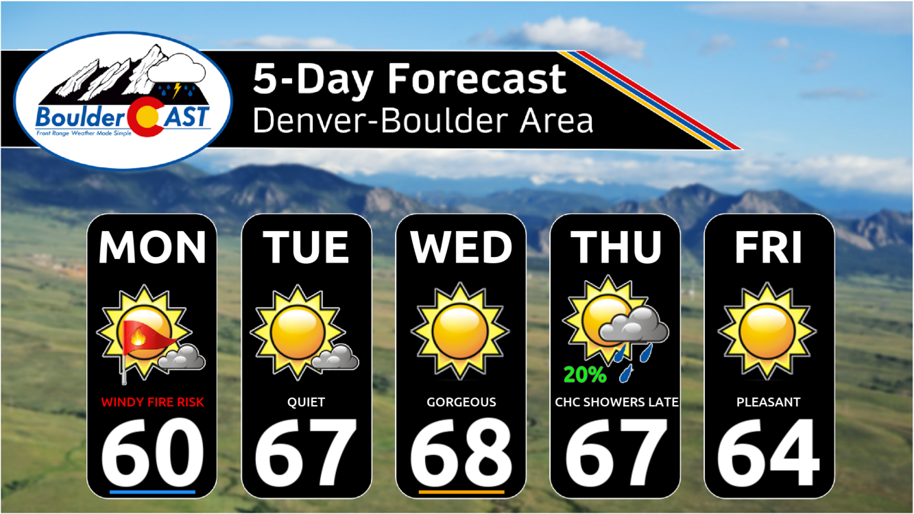
This week’s forecast is anything but boring in the Front Range. A fast-moving autumn storm is stirring up the atmosphere on Monday with jet-driven Mountain snow, powerful downslope winds, and a fire-weather setup that demands caution. And once the winds die down? A hard freeze will slam the door on the growing season for the entire area Monday night. Read on for a full breakdown of the very active weather unfolding in Colorado on Monday, plus a peek towards the quieter days ahead.
This week’s highlights include:
- ❄️ Quick Mountain Snow Monday AM: A powerful 135+ MPH jet streak embedded in a deep upper-level trough is racing across northern Colorado. Its right-entrance region is enhancing lift, producing brief bands of snow before 10AM Monday along and north of I-70. Expect 1–3″ of accumulation and possible whiteout conditions if traveling in the High Country.
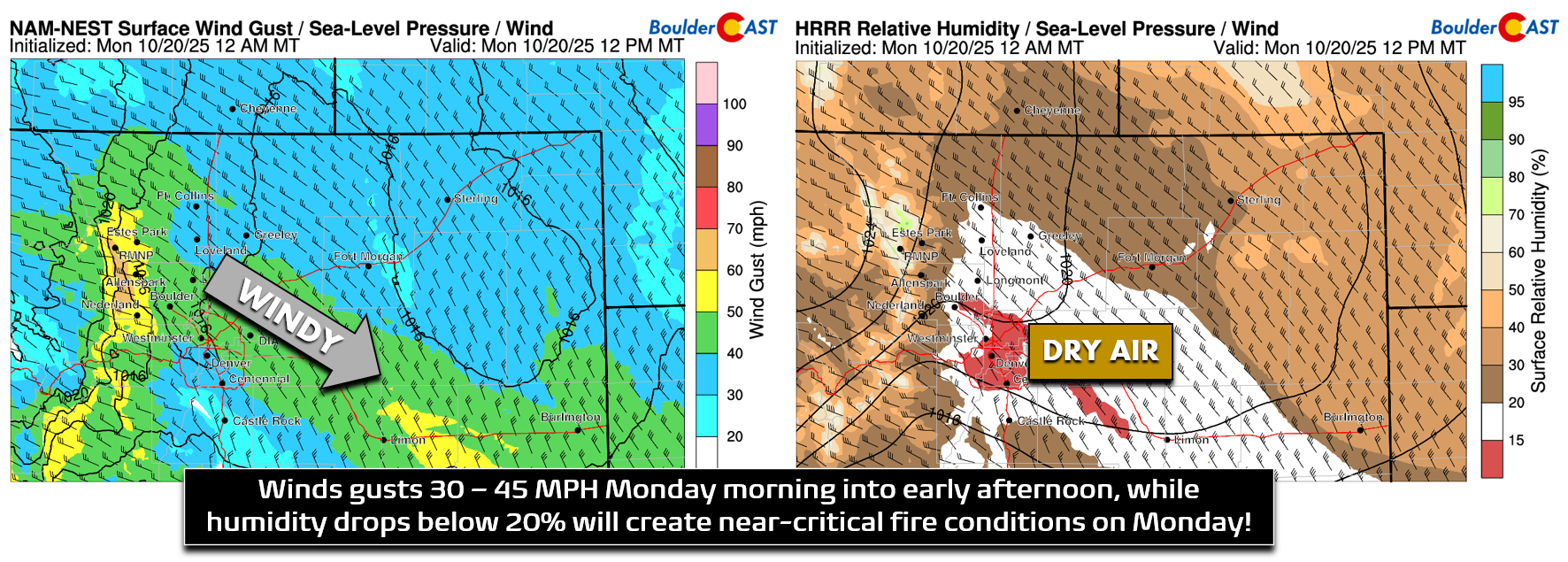
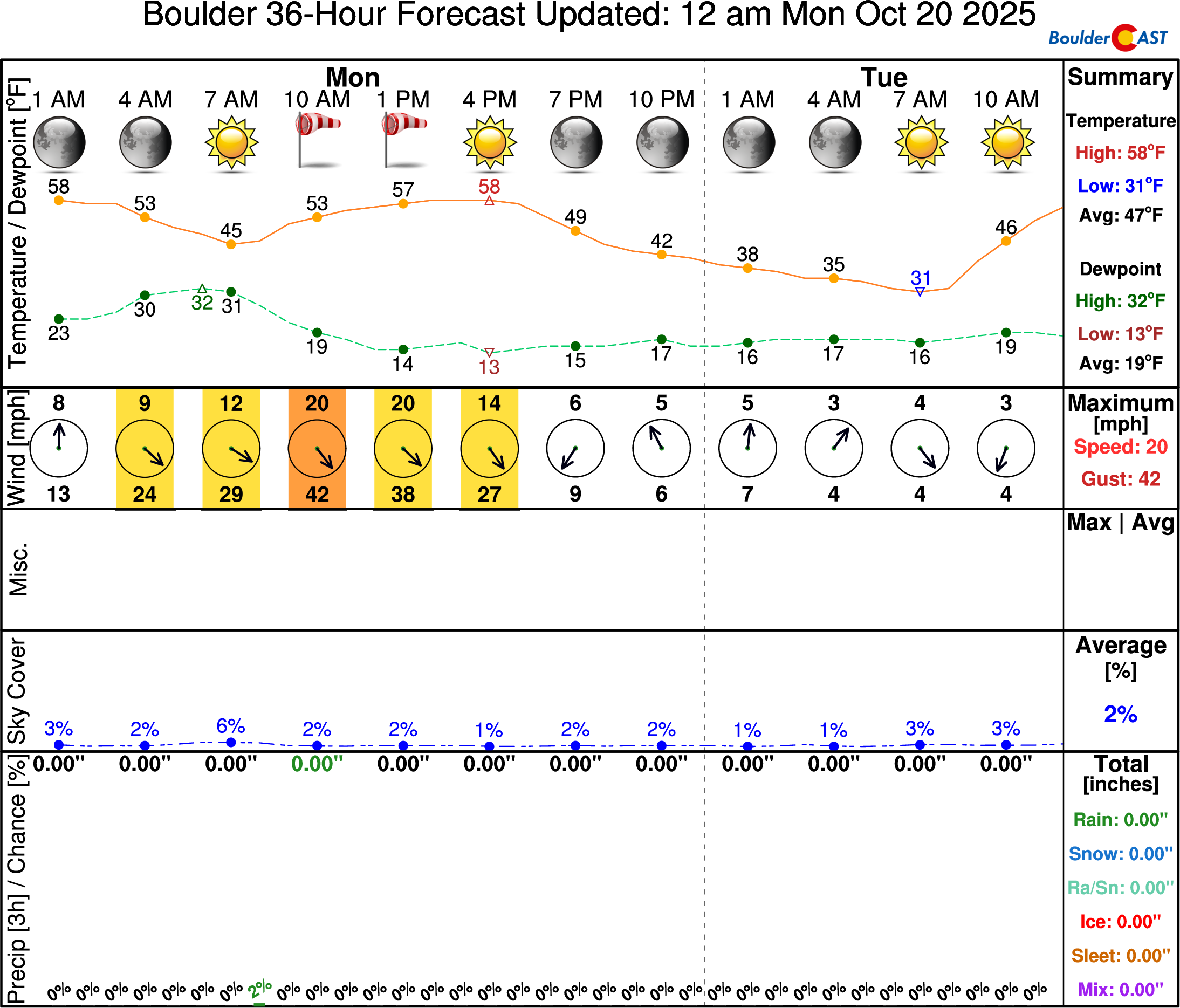
- 💨 Strong Downslope Winds Develop Monday: As the trough digs in and a cold front sweeps southward, strong west-northwest winds develop across the Foothills and Plains. Gusts of 30–50 MPH will be widespread, with isolated peaks up to 75 MPH in wind-prone zones like southwest Boulder and Rocky Flats.
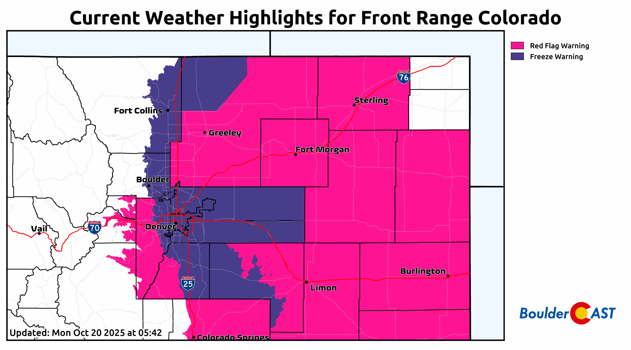
- 🔥 Critical Fire Setup Monday: The storm’s dry slot and subsidence behind it will usher in low humidity and strong winds. Fuels are dormant and primed to burn despite cooler temps in the 50s–60s. Red Flag Warnings are active from 9AM to 6PM across the Denver Metro on Monday.
- 🧊 Killing Freeze Monday Night: As the system exits and skies clear, strong radiational cooling will drop temps below freezing across eastern Colorado. Freeze Warnings are in effect — this marks the end of the growing season for areas that dodged Sunday’s frost.
- ☀️ Sunny Midweek Rebound: Highs in the mid to upper 60s Tuesday through early Thursday under a developing ridge. Very sunny Tuesday and Wednesday with more clouds Thursday. Highs pleasant in the mid to upper 60s.
- 🌧️ Late-Week Rain Chance? A weak cut-off low may bring a few showers to the area Thursday or Thursday night, but latest model trends take the storm and most of its impacts south of Denver.
DISCLAIMER: This weekly outlook forecast is created Monday morning and covers the entire upcoming week. Accuracy will decrease as the week progresses as this post is NOT updated. To receive daily updated forecasts from our team, among many other perks, subscribe to BoulderCAST Premium.

Go Premium, get all the perks.
Daily Forecast Updates
Get our daily forecast discussion every morning delivered to your inbox.
All Our Model Data
Access to all our Colorado-centric high-resolution weather model graphics. Seriously — every one!
Ski & Hiking Forecasts
6-day forecasts for all the Colorado ski resorts, plus more than 120 hiking trails, including every 14er.
Smoke Forecasts
Wildfire smoke concentration predictions up to 72 hours into the future.
Exclusive Content
Weekend outlooks every Thursday, bonus storm updates, historical data and much more!
No Advertisements
Enjoy ad-free viewing on the entire site.
An Active Monday: Brief Mountain snow, strong winds and fire danger followed by a widespread freeze
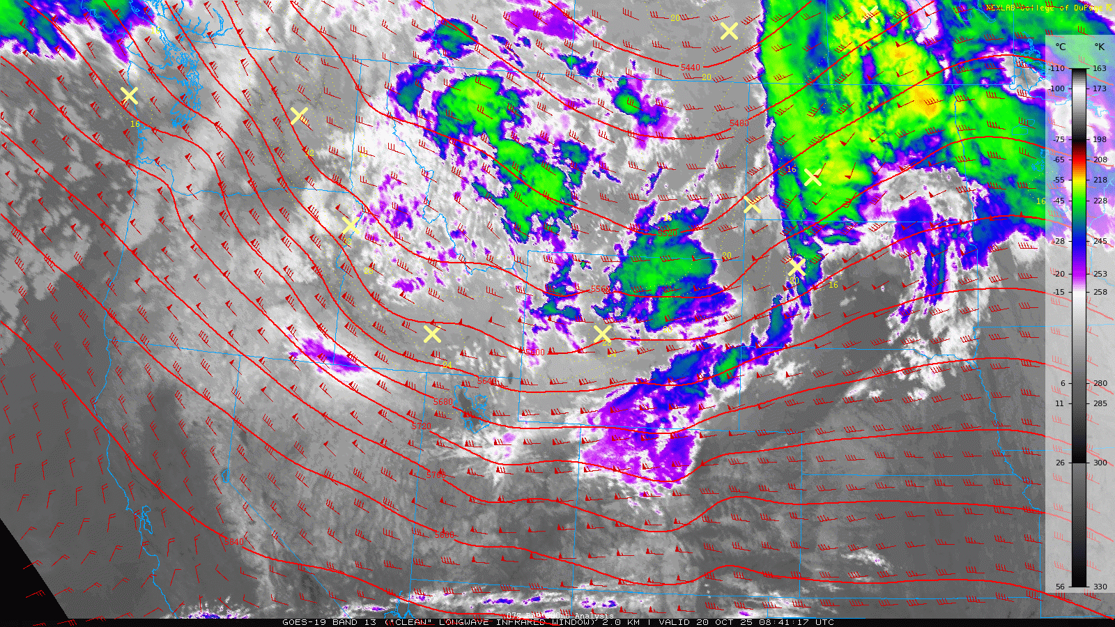
As of Monday morning, a strong autumn storm system is sweeping through the northern Rockies, anchored by a broad upper-level trough. Infrared satellite imagery shows a well-defined band of clouds and precipitation pushing into Colorado’s high country from Wyoming. Meanwhile, a cold front is surging south across eastern Colorado, visible as a subtle dark streak on the satellite loop just before sunrise.
Most of the storm’s moisture and lift will stay north of us (so yes, our 2025 First Snow Contest lives on…), but we’re catching the windy side of the system. Expect strong west-northwest winds to ramp up quickly after sunrise, especially across the Foothills and adjacent Plains.
Gusts of 30–50 MPH will be widespread, with isolated peaks up to 75 MPH possible in classic wind-prone zones like southwest Boulder, Rocky Flats, and Golden. Winds will peak in the morning, stay blustery through the afternoon, and ease off toward sunset.
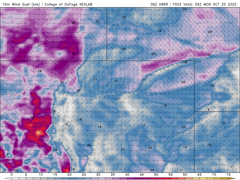
HRRR forecast wind gusts during the day Monday
The combo of gusty winds and dry air will push fire danger into near-critical territory. While humidity levels aren’t bottoming out, they’re low enough, and fuels are dry enough to warrant concern. Red Flag Warnings are in effect for the entire Denver Metro from 9AM to 6PM. Temps will hover in the middle 50s to near 60, but don’t let the cooler air fool you: dormant vegetation is primed to burn under these whipping winds!
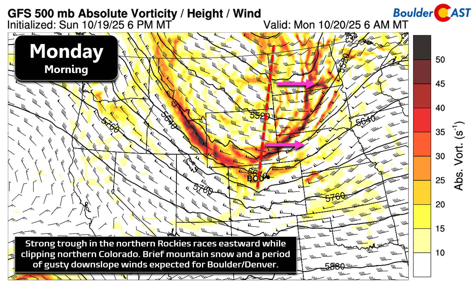
Embedded in the trough is a powerful jet streak, clocking over 135 MPH aloft, racing across northern Colorado. Its right-entrance region, paired with the frontal push, will spark a brief burst of banded snow in the Mountains early Monday.
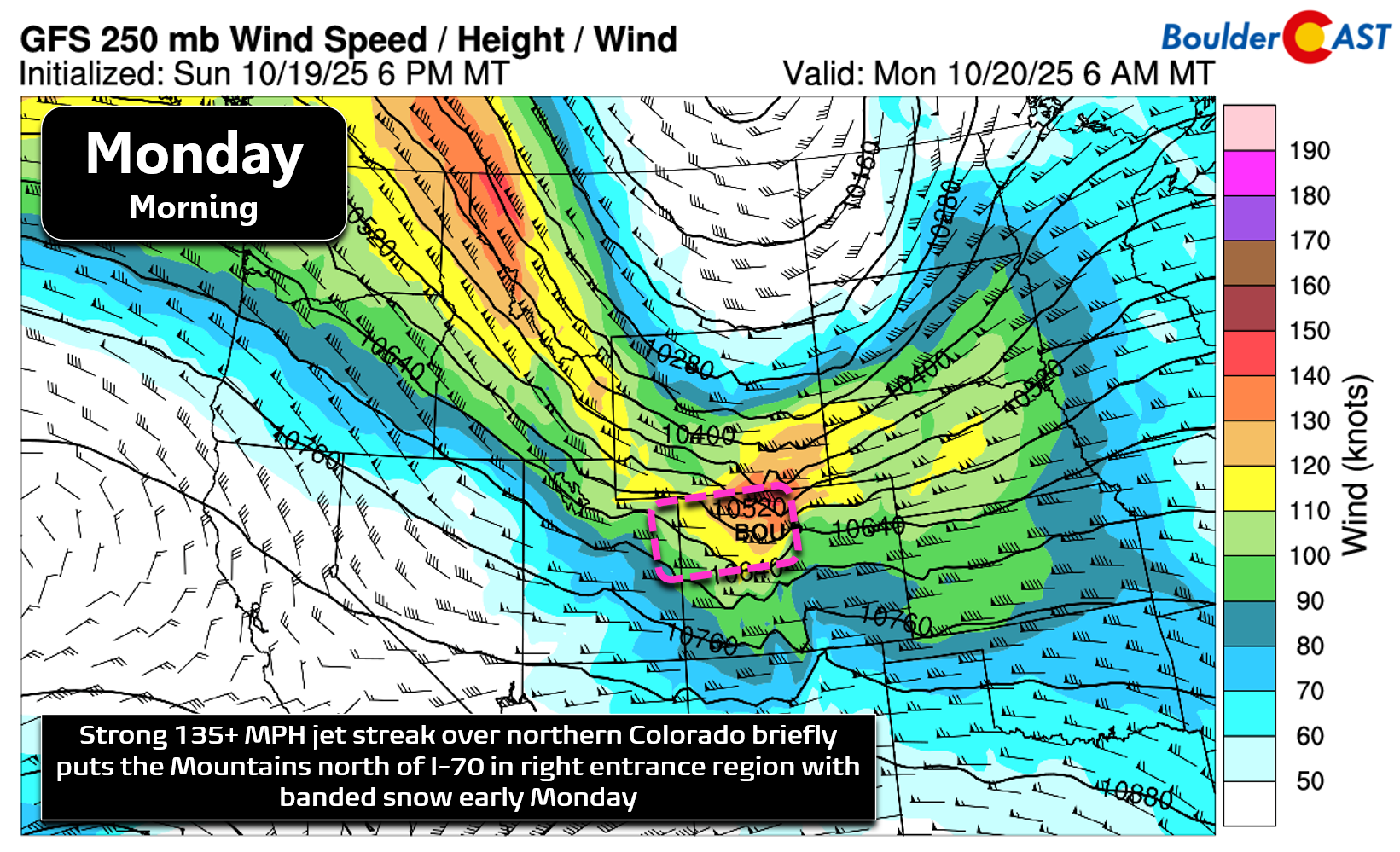
Expect 1–3 inches of accumulation along and west of the Divide, with brief whiteout conditions possible before 10AM, especially near and north of I-70. A few raindrops may spill out across the lower elevations Monday morning, but that should be localized.
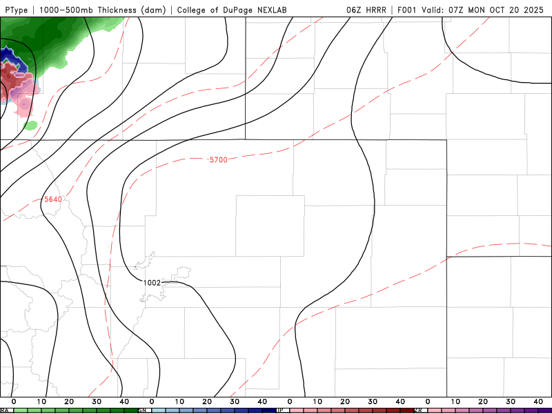
HRRR forecast precipitation for Monday showing bands of snow sagging south early Monday in the Mountains
Once the winds settle, skies will clear and radiational cooling will kick in hard. A widespread killing freeze is expected Monday night into Tuesday morning, with temps dropping below freezing across all of eastern Colorado. If your garden dodged Sunday’s frost, it won’t escape tonight. Freeze Warnings are in effect — now is the time to drain exposed pipes and disconnect hoses before the cold hits!
Our Monday forecast is a busy one in northern Colorado, but here’s a brief recap of the conditions to plan for:
- ❄️ Mountain Snow: Bands of snow before 10AM, 1–3″ possible, brief whiteouts cause travel issues.
- 💨 Wind & Fire Risk: Gusts 30–50 MPH (up to 75 MPH in Foothills), Red Flag Warnings until 6PM.
- 🧊 Killing Freeze: Subfreezing temps widespread Monday night, Freeze Warnings in effect.
Looking ahead to quieter days
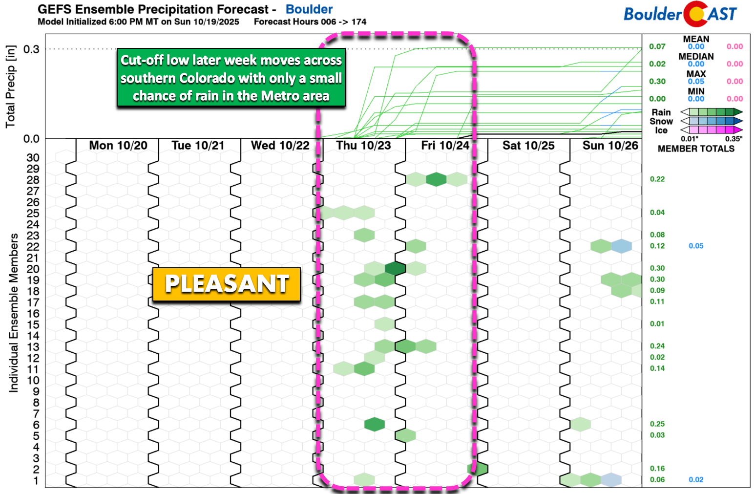
After Monday’s storm zips east, we settle into a calmer stretch Tuesday through Thursday. A ridge builds in, bringing sunny skies and highs in the mid to upper 60s, a pleasant rebound. By late Thursday, a cut-off low may drift in from the southwest. It’s small, warm, and weak, and current model trends keep most of its rain south of Boulder and Denver.
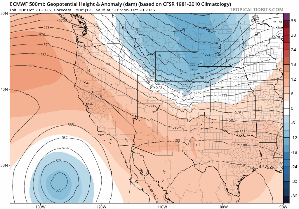
Euro 500mb height anomaly forecast for Monday through Friday showing the early week trough exiting, the midweek ridge, and the cut-off low late-week.
Still, cut-off lows are notoriously tricky to pin down four days out, so we’re tagging a 20% chance of showers Thursday afternoon into the night. However, do note that the most favored model outcome is for most of the rain to stay south of Denver, but time will tell.
Friday cools off a few degrees, but with sunshine holding strong, you might not even notice. After the wild weather on Monday, we deserve the quiet and mild stretch set to unfold the rest of the week. Enjoy!
Forecast Specifics:
Monday: Mostly sunny but very windy with gusts of 30 to 50 MPH during the morning into afternoon. Localized gusts up to 75 MPH possible in and near the Foothills briefly in the morning. A few snow showers possible Monday morning in the Foothills. Otherwise dry with near-critical fire conditions on the Plains. Highs near 60 degrees on the Plains with middle 40s in the Foothills. Plan for a hard freeze Monday night!
Tuesday: After a killing freeze in the morning, temperatures warm nicely under mostly sunny skies. Highs in the middle to upper 60s on the Plains with middle 50s in the Foothills.
Wednesday: Lots of sun with light winds and warm temperatures. Highs top out in the upper 60s on the Plains with middle 50s in the Foothills.
Thursday: Partly to mostly cloudy with a slight chance of a rain shower in the late-day or overnight period. Highs stay warm in the middle to upper 60s on the Plains, with middle 50s in the Foothills.
Friday: Quiet, pleasant and sunny. Highs a tad cooler in the low to middle 60s on the Plains with lower 50s in the Foothills.
Weekend: Warm and dry with highs in the upper 60s to middle 70s.
DISCLAIMER: This weekly outlook forecast is created Monday morning and covers the entire upcoming week. Accuracy will decrease as the week progresses as this post is NOT updated. To receive daily updated forecasts from our team, among many other perks, subscribe to BoulderCAST Premium.
Go Premium, get all the perks.
Daily Forecast Updates
Get our daily forecast discussion every morning delivered to your inbox.
All Our Model Data
Access to all our Colorado-centric high-resolution weather model graphics. Seriously — every one!
Ski & Hiking Forecasts
6-day forecasts for all the Colorado ski resorts, plus more than 120 hiking trails, including every 14er.
Smoke Forecasts
Wildfire smoke concentration predictions up to 72 hours into the future.
Exclusive Content
Weekend outlooks every Thursday, bonus storm updates, historical data and much more!
No Advertisements
Enjoy ad-free viewing on the entire site.
Enjoy our content? Give it a share!


You must be logged in to post a comment.