
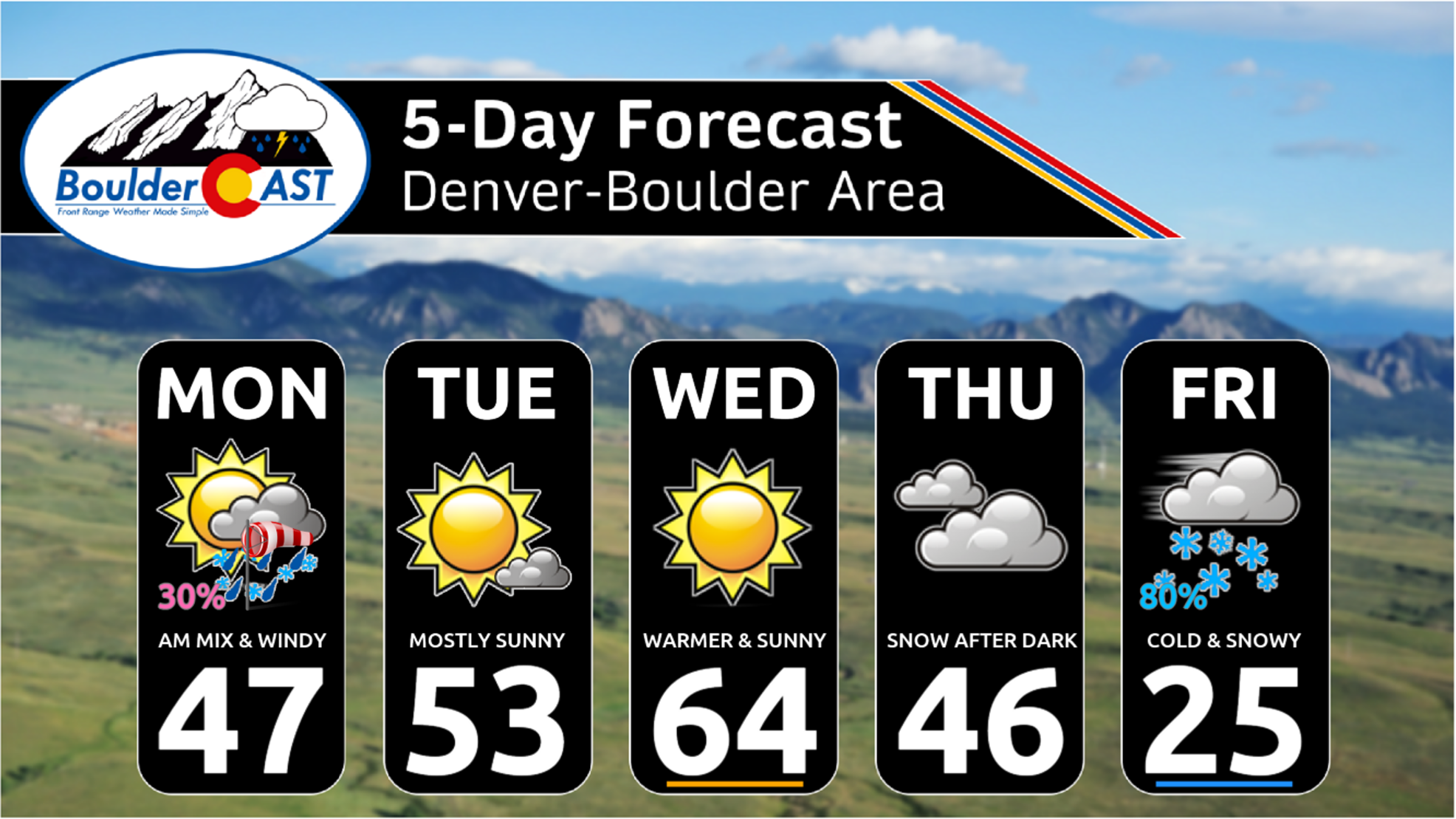
This week will offer up the most exciting weather we’ve had across the Front Range in a long time. We’ve got rain showers, high winds, freezing drizzle, bitter cold temperatures and accumulating snow headed our way, but there will still be a few beautiful days mixed in as well. Read on for the latest details on what should be a interesting week in Colorado weather!
This week’s highlights include:
- A powerful low pressure in Kansas will produce gusty northerly winds on Monday alongside a chance of rain/snow showers Monday morning — light accumulations possible above 6500 feet
- A ridge will build in Tuesday and Wednesday with above normal temperatures and sunshine taking over — temperatures peak in the middle 60s by midweek
- Another, colder storm system is headed our way Thursday into Friday with winter weather likely to impact Thanksgiving travel plans
- Light snow will begin to develop Thursday evening after dark, possibly mixing with freezing drizzle at the onset, with light snow then continuing into Friday
- While still early, there is good model agreement for 2-7″ of snow accumulation with this long-duration late-week system, plus highs only in the 20s for Friday
DISCLAIMER: This weekly outlook forecast is created Monday morning and covers the entire upcoming week. Accuracy will decrease as the week progresses as this post is NOT updated. To receive daily updated forecasts from our team, among many other perks, subscribe to BoulderCAST Premium.

Go Premium, get all the perks.
Daily Forecast Updates
Get our daily forecast discussion every morning delivered to your inbox.
All Our Model Data
Access to all our Colorado-centric high-resolution weather model graphics. Seriously — every one!
Ski & Hiking Forecasts
6-day forecasts for all the Colorado ski resorts, plus more than 120 hiking trails, including every 14er.
Smoke Forecasts
Wildfire smoke concentration predictions up to 72 hours into the future.
Exclusive Content
Weekend outlooks every Thursday, bonus storm updates, historical data and much more!
No Advertisements
Enjoy ad-free viewing on the entire site.
Rain/snow mix & windy on Monday
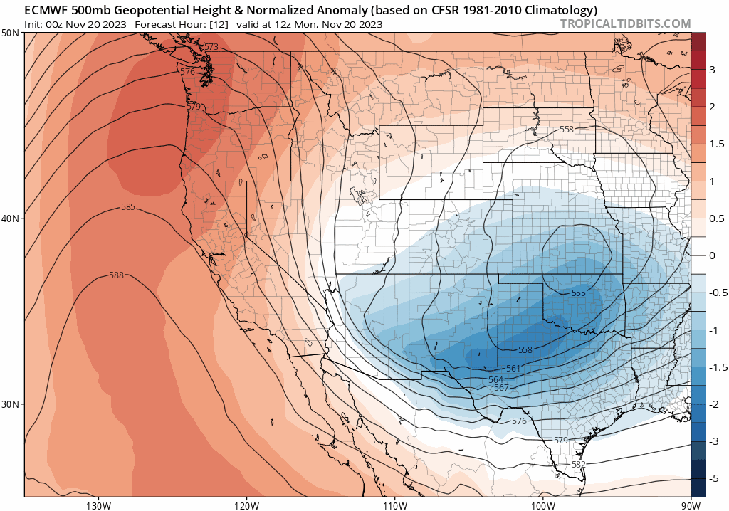
We kick off the week with an immediate chance of rain/snow showers across the Front Range on Monday as a strong storm system blows up just to the east of Colorado. This system will not only offer up the precipitation chance here but it will finally bring an end to our lengthy warm stretch as well. We’ve been discussing the impacts of this system the last few days, but really it won’t do much here as the developing core of the storm is well to the east putting our area in a less-than-favorable northerly flow regime. As of Monday morning, the intensifying mid-level low pressure center is located in central Kansas, as shown in the impressive GOES-East infrared satellite animation below. Back across our area, north-northwesterly flow is occurring right now.

Short-range models do show an uptick in the coverage of precipitation across the Metro area Monday morning as a weak disturbance sags southward in tandem with northerly flow. Clouds from this approaching disturbance can be seen across Wyoming in the animation above. Similar to our most recent precipitation event, cold air is limited and thus it will be mostly rain for the lower elevations as temperatures fail to cool below the middle to upper 30s in Denver and Boulder.
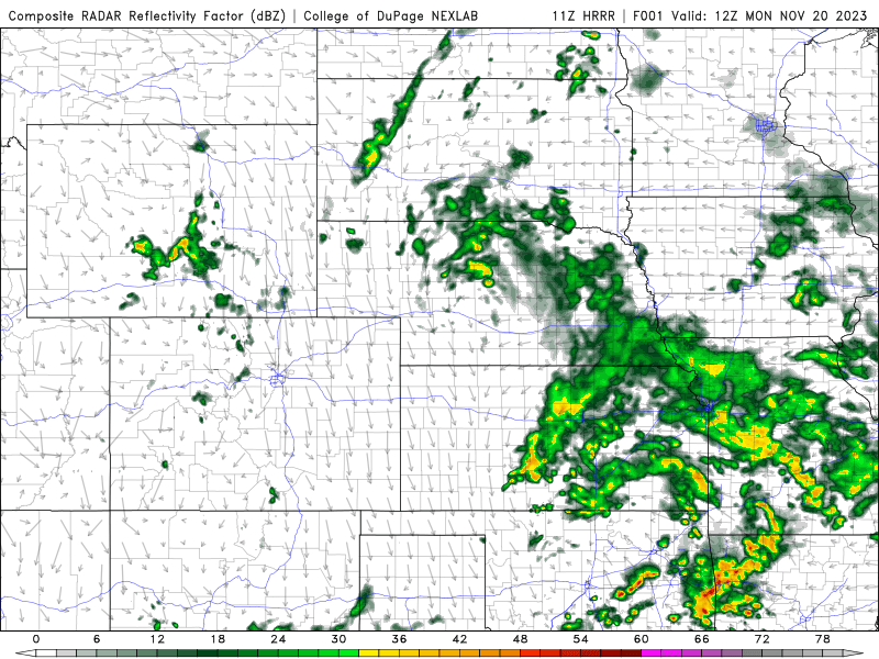
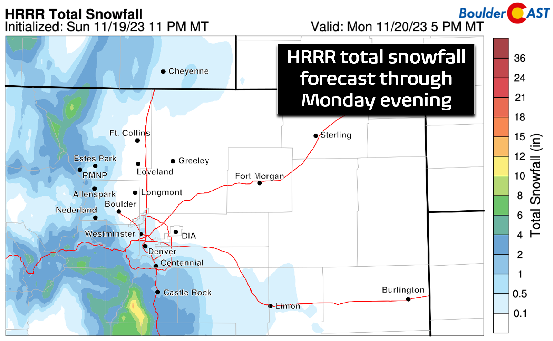
Some light snow accumulations will be possible above 6500 feet elevation on Monday where temperatures will be in the low to middle 30s, with a focus in the far southern Foothills and Palmer Divide Monday morning — up to a couple of inches may stick on grassy surfaces there. Under northerly flow, most of the precipitation is expected to be south of Interstate 70 and primarily even south of Denver where low-level upslope will be aiding things nicely.
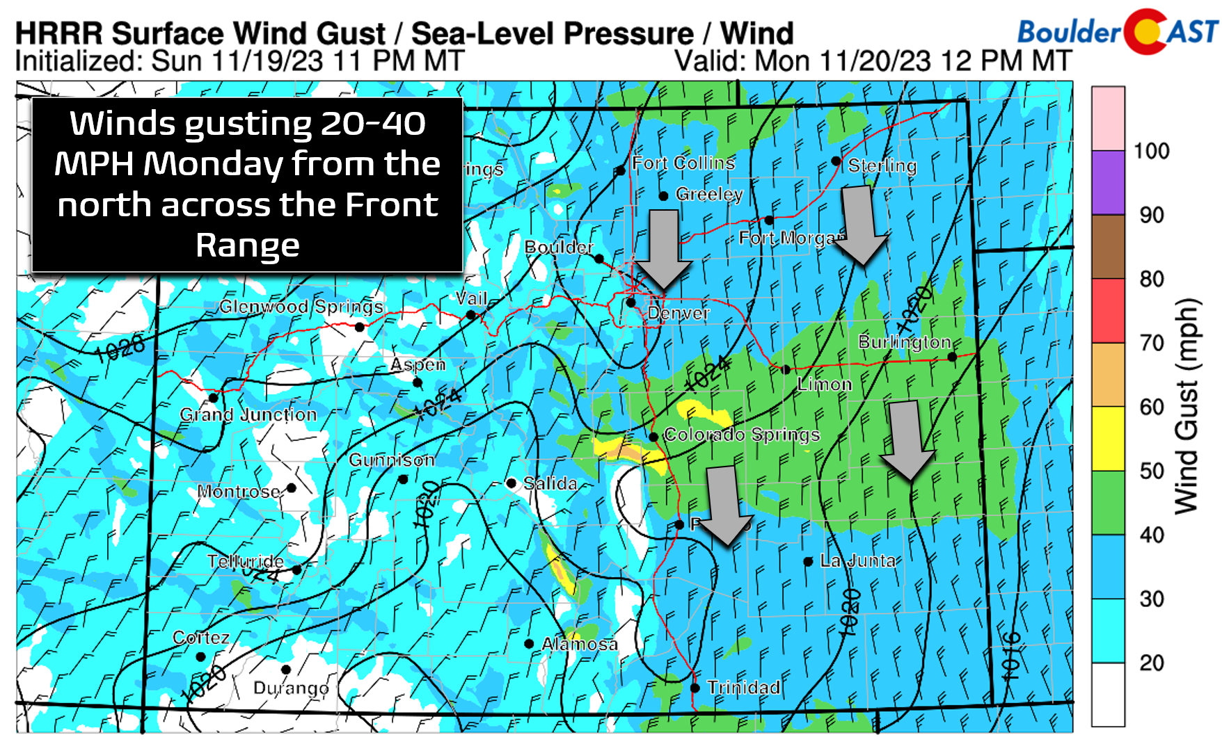
With snowflakes mostly off the table, the more widespread impact for our area on Monday will be the gusty northerly winds thanks to the heightened pressure gradient behind the strong low. Winds will be strongest across the Palmer Divide and east of Interstate 25 where gusts of 40-50 MPH will be possible. However, back in Boulder and Denver, gusts of 20-40 MPH will be more common throughout the day Monday.
So yes, Monday will be the most active weather day we’ve had in a long time, but to be fair that’s not saying much and it’s nothing out of the ordinary for late November. The best chance of seeing a few rain/snow showers comes during the morning hours — roughly from 7AM to Noon. Precipitation will clear out in the afternoon with a dry end to the day expected and possibly a few peeks of sunshine working in. Highs on Monday will top out in the middle 40s.

Quiet Tuesday & Wednesday
After Monday’s quick bout of unsettled weather, a strong (but short-lived) ridge will move in behind the exiting trough with high pressure building back in across Colorado from the west (see animation below). This will allow for a rebound in temperatures and dry conditions for us on both Tuesday and Wednesday. High temperatures will warm back into the middle 50s on Tuesday and then well above normal into the middle 60s by Wednesday.
Winter returns Thanksgiving night
As we head into Turkey Day, Mother Nature will give the gift of winter weather back to the Front Range as another, colder storm system is going to drop into the central Rockies. Global models are coming into better agreement on this event already, even three to four days out, so our confidence is quite high that we will see a return of accumulating snow across our area Thursday night into Friday. The late-week trough isn’t all that impressive, but it will be slow-moving which will allow for an extended period of light snowfall across our area forced by favorable easterly upslope flow in the low levels as well as the trough which will be passing through.
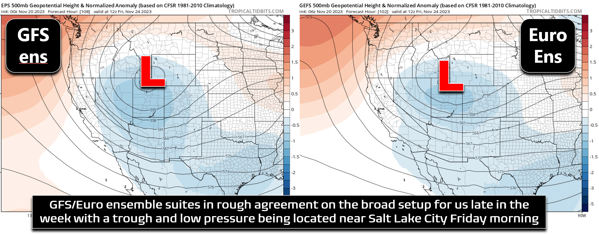
This event will mainly be forced by anti-cyclonic upslope associated with a pseudo-Arctic high pressure dropping southward out of Canada and into Montana late in the week (see forecast map below). While this means there will be a prolonged period of cold upslope due to the slow-moving nature and large size of the high pressure system, it won’t be a terribly exciting or dynamic event. The initial cold front will move in sometime Wednesday evening, dropping our high temperatures back into the 40s for Thanksgiving Day with overcast skies. Things will remain too dry for any precipitation to form behind this initial front — good news for those traveling for the holiday. It’s not until Thursday evening that things will turn more troublesome. Upslope flow will start to intensity and moisture will get drawn into the Front Range from the southeast with precipitation expected to commence before midnight Thursday night — though timing is still not locked in. Typically southeast flow at the onset of these type of events would favor freezing drizzle over snowflakes, so we may have a light glaze of ice to deal with first Thursday evening before the accumulating snow begins.
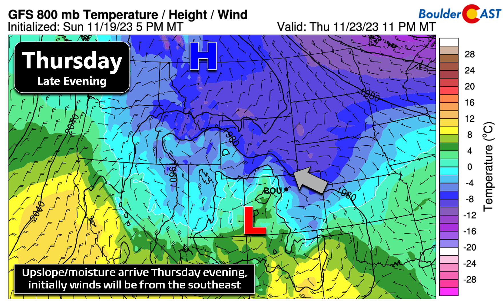
Thursday night into Friday morning, upslope will become more favorable for us with almost due easterly flow across all of eastern Colorado. Temperatures will also cool further allowing for a full change-over from wintry mix to all snow. Light snow will then stick around through the day Friday and maybe even into Friday night if some of the slower model solutions verify. Snowfall rates should be rather light throughout the duration of the event — remember this will be a long, drawn-out, and predominantly light snow affair. Temperatures will be steady in the 20s or continue to fall through the day Friday. Plan ahead now for a very cold and somewhat snowy end to the week!

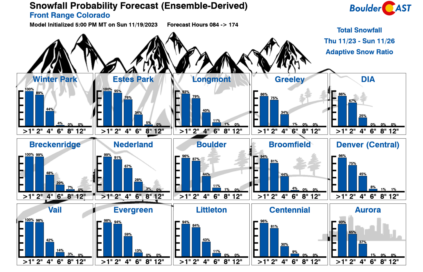
As far as potential snow accumulations from the late-week storm, most model guidance suggests a broad-brush of 2 to 7″ for the Boulder-Denver area with the higher totals in and near the base of the Foothills. We do expect a decent gradient in snowfall amounts moving away from the terrain from this upslope-focused event. Our latest Snowfall Probabilities are shown below. There will surely be some travel impacts — especially on the backside of Thanksgiving festivities Thursday night and through the day Friday — but it won’t be too bad overall.
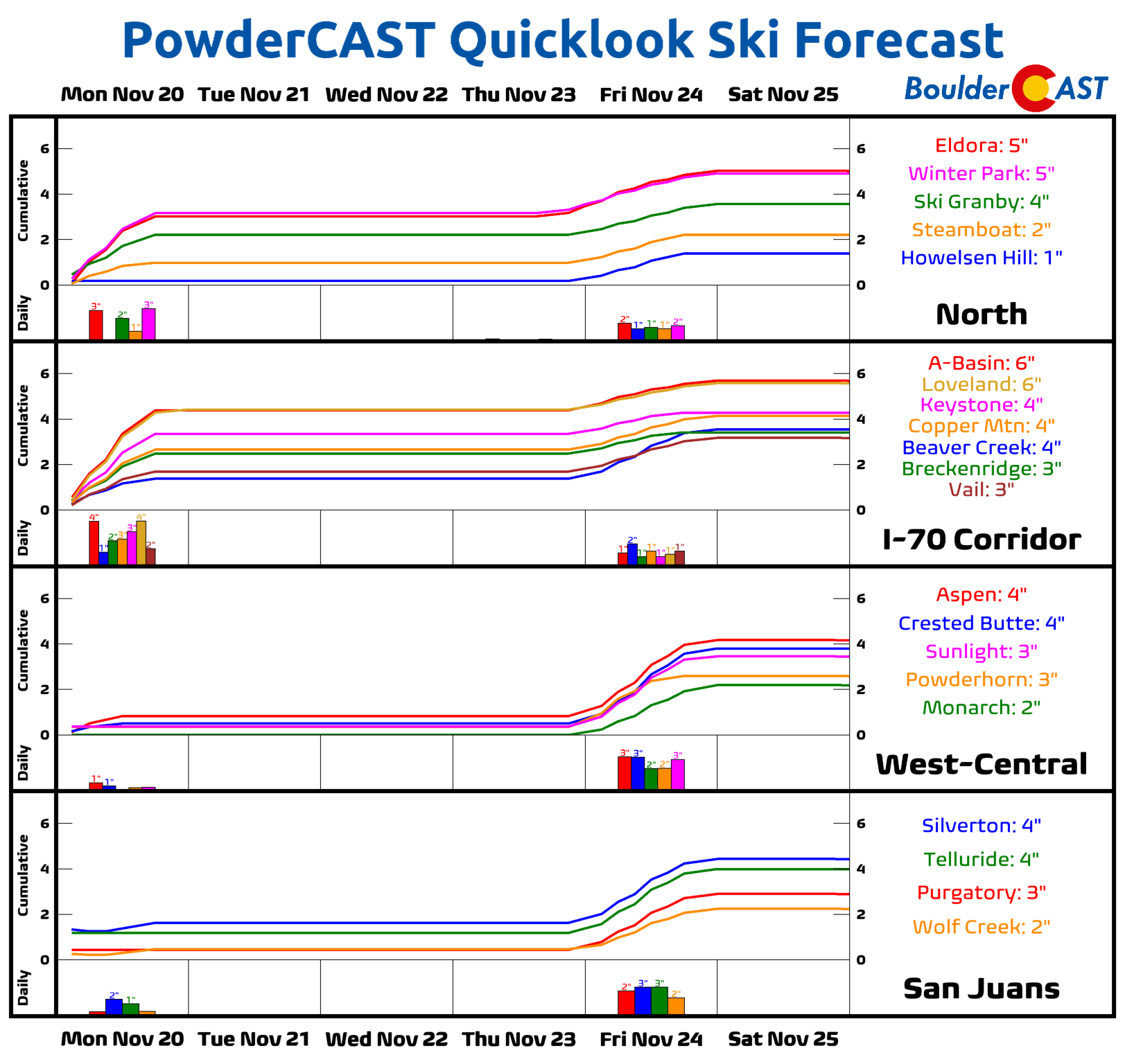
Sadly, this really isn’t the type of storm that will favor the Mountains for much snowfall late in the week. Skiing over the holiday weekend should be just okay with 1 to 4″ of fresh snow expected at most of the resorts.
So to recap the week, we have the brief and splotchy rain/snow mix Monday morning, then mild/dry weather Tuesday and Wednesday, followed by developing wintry mix/snow Thursday evening and into Friday.

Stay tuned as we continue to track the next storm system arriving on Thanksgiving evening! As always, follow us on Twitter, Threads and Facebook for more punctual weather updates, and be sure to subscribe to our email list for instant notifications when our broader storm updates similar to this one are published. Enjoy the rollercoaster ride of weather this week!
Get BoulderCAST updates delivered to your inbox:
Forecast Specifics:
Monday: Overcast skies early with a chance of rain/snow showers in the morning hours. Light accumulations possible above 6500 feet elevation. We dry out by afternoon with a few peeks of sunshine possible before sunset. Highs reach the middle to upper 40s on the Plains with middle 30s in the Foothills. Winds will be blustery out of the north and northwest during the day, gusting 20 to 40 MPH.
Tuesday: Mostly sunny and dry. Temperatures top out in the low to middle 50s across the Plains with lower 40s in the Foothills.
Wednesday: Sunny and warmer with temperatures in the middle 60s on the Plains and lower 50s in the Foothills.
Thursday: A cooler day with overcast skies and highs somewhere in the 40s. Light snow, possibly preceded by a period of freezing drizzle, will develop during the evening hours and continue through the overnight.
Friday: Light snow will linger through most of the day, especially for the western Metro area. Bitter cold temperatures holding steady in the 20s are expected during the day. Snow should wrap-up sometime Friday evening or night for everyone. Total accumulations of 3-6″ are expected (as of writing Monday morning), but this could change.
DISCLAIMER: This weekly outlook forecast is created Monday morning and covers the entire upcoming week. Accuracy will decrease as the week progresses as this post is NOT updated. To receive daily updated forecasts from our team, among many other perks, subscribe to BoulderCAST Premium.
Go Premium, get all the perks.
Daily Forecast Updates
Get our daily forecast discussion every morning delivered to your inbox.
All Our Model Data
Access to all our Colorado-centric high-resolution weather model graphics. Seriously — every one!
Ski & Hiking Forecasts
6-day forecasts for all the Colorado ski resorts, plus more than 120 hiking trails, including every 14er.
Smoke Forecasts
Wildfire smoke concentration predictions up to 72 hours into the future.
Exclusive Content
Weekend outlooks every Thursday, bonus storm updates, historical data and much more!
No Advertisements
Enjoy ad-free viewing on the entire site.
Enjoy our content? Give it a share!


You must be logged in to post a comment.