
After a very cold and wintry weekend, the week ahead will be…well, unfortunately more of the same. We will enjoy a little bit of sunshine Monday and Tuesday, but yet another Arctic blast will arrive Wednesday to keep things cold and/or snowy for the rest of week. We discuss the expected timing of the Arctic front, potential fluffy snowfall amounts, and just how cold it will get later this week.
This week’s highlights include:
- Both days of the weekend were wintry with freezing drizzle, light snow and very cold temperatures
- A slight warming trend ensues to start the week with some sunshine for Monday and Tuesday
- The next blast of Arctic air will take hold on Wednesday with plummeting temperatures during the day and snowfall developing by afternoon or evening
- Snowfall totals Wednesday into Thursday look to be in the 3 to 8″ range for the Metro area
- Frigid temperatures are expected alongside the snow — highs only in the teens Thursday, near zero Thursday night and then just 20’s on Friday
- Quieting down and warming up for the weekend ahead
DISCLAIMER: This weekly outlook forecast is created Monday morning and covers the entire upcoming week. Accuracy will decrease as the week progresses as this post is NOT updated. To receive daily updated forecasts from our team, among many other perks, subscribe to BoulderCAST Premium.

Recap: March’s first snow
This past weekend’s weather was far from nice with wintry conditions unfolding both days. Saturday had low clouds, freezing drizzle and light snow across some of the area. The icing was particularly nasty in Boulder Saturday morning and afternoon. Sunday was even colder with continuous light to moderate snowfall dumping across the entire area with highs only in the lower 20’s!
As of 12PM, a little over 3" of snow has fallen in Boulder, but roadways are mostly just wet. Light snow with occasional moderate bursts will continue into the evening #COwx #Boulderwx #Boulder pic.twitter.com/PgUorvu0GF
— BoulderCAST Weather (@BoulderCAST) March 6, 2022
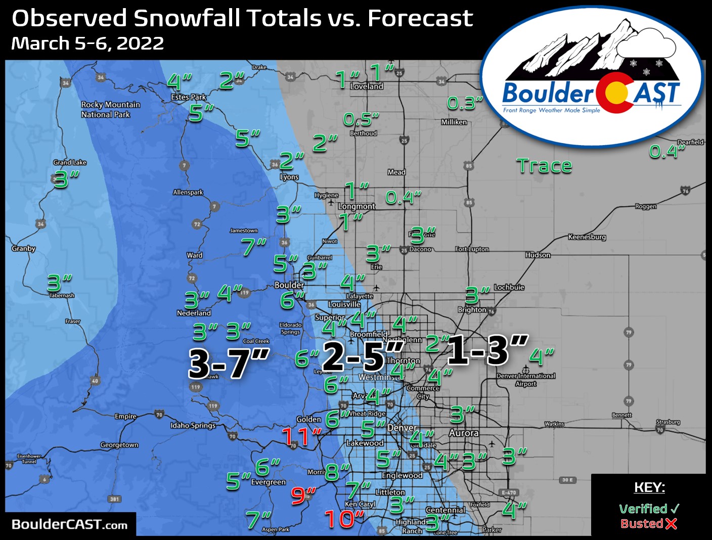
While the two distinct storm systems impacting the area over the weekend didn’t play out exactly as forecast, the result ended up about the same. Most areas saw between 1 to 6″ of snow over the weekend, though a few “lucky” spots in Jefferson County picked up more than 8″. Our snowfall forecast map for the main event issued Saturday evening is shown below with storm totals overlaid. Green numbers indicate our forecast verified to within 1″. Red did not. Boulder officially reported around 6″ of snow accumulation (exact amount still TBD), while Denver reported 4.3″ at the airport. The highest totals of 8 to 11″ were observed in the Jefferson County Foothills and nearby areas.
The week ahead: Another Arctic blast incoming
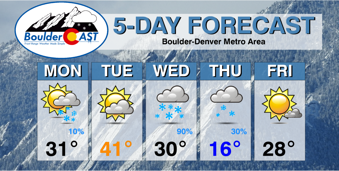
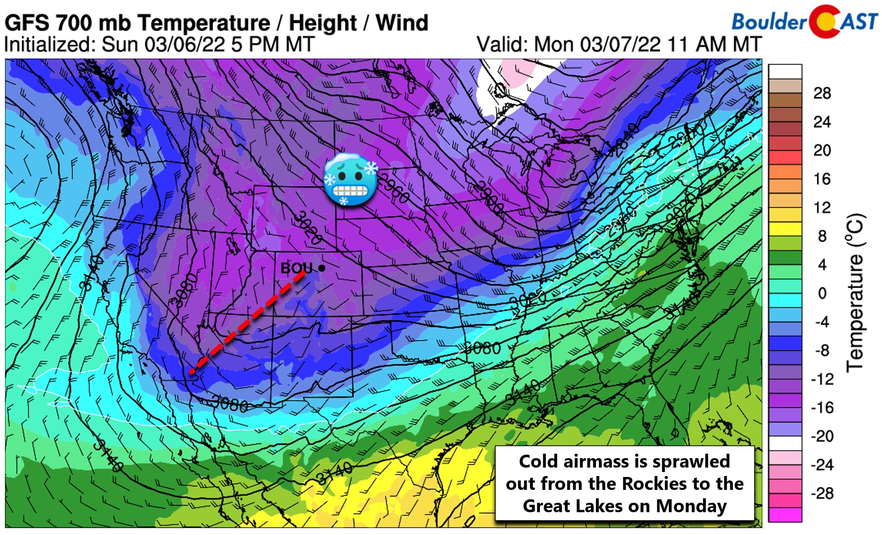
We begin the week still dealing with the fallout from the weekend’s winter festivities — the very cold airmass is holding strong across all of Colorado on Monday. Note the cold air stretching from the Four Corners region into the Great Lakes in the 700mb temperature forecast for midday Monday below. Despite our temperatures starting to trend upward, it’ll be far from warm any day this week! Highs on Monday will only get into the lower 30’s thanks mostly to sunshine helping to moderate the cold airmass.
There is a weak disturbance moving through embedded in the large troughy pattern which will work to develop light snow showers across the Mountains through the day aided by solar heating. There is a slight chance these showers clip the southern portions of the Denver Metro by afternoon and evening on Monday. The best chances for a light dusting of snow will be across the Palmer Divide and Jefferson County Foothills. The odds of any snowflakes in Boulder and Denver on Monday are fairly low — around 10%.
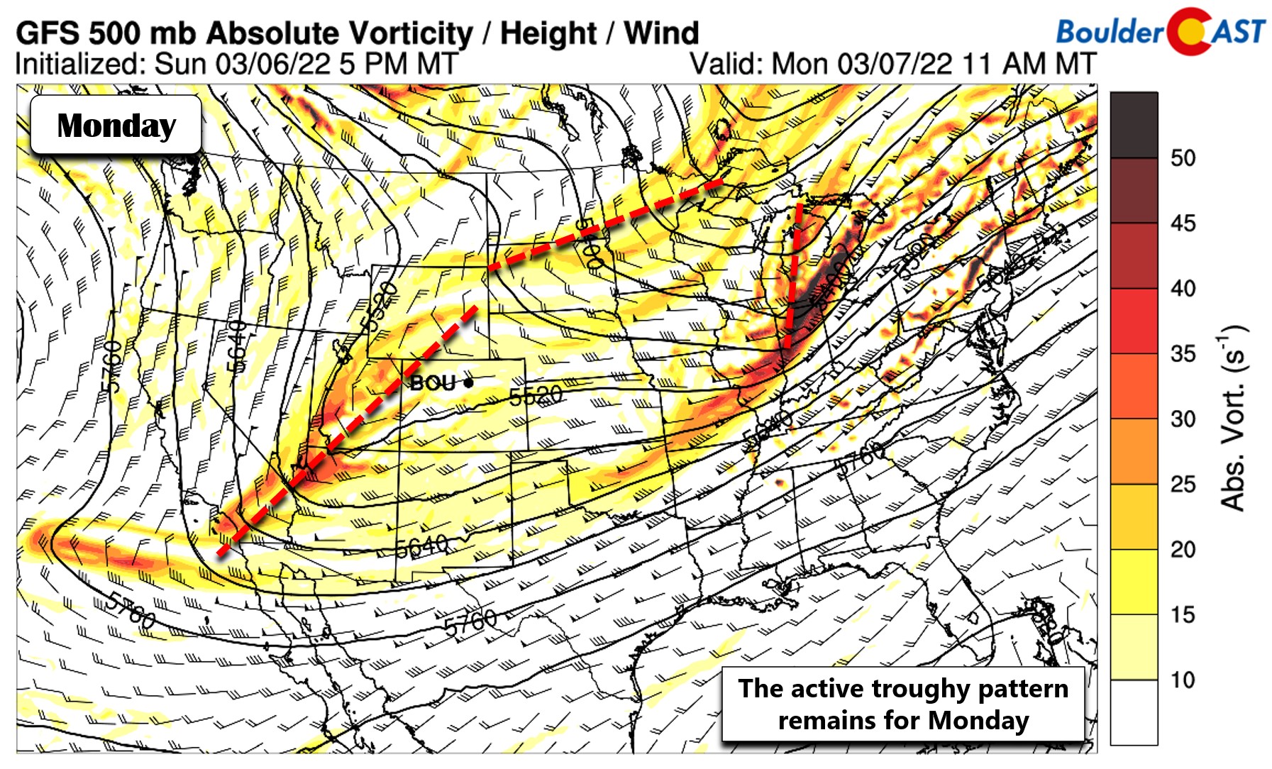
The aforementioned disturbance will quickly kick eastward and be gone from Colorado by midday Tuesday. However, the next winter blast will already be entering the picture in the form of an Arctic cold front dropping south out of central Canada. Because of what we expect to transpire once this front moves into our area, Tuesday will likely be the warmest day of the week with highs near 40 degrees. That’s still some 15 degrees below normal for this time of year.
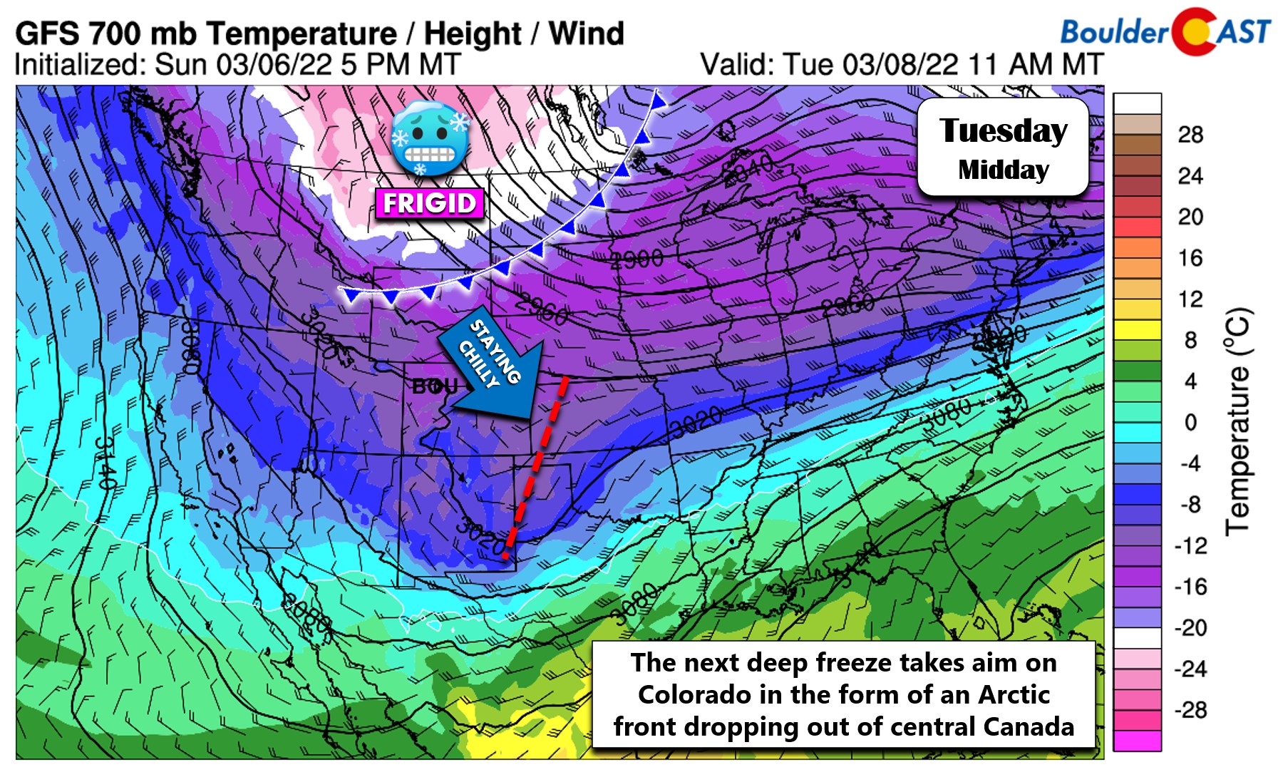
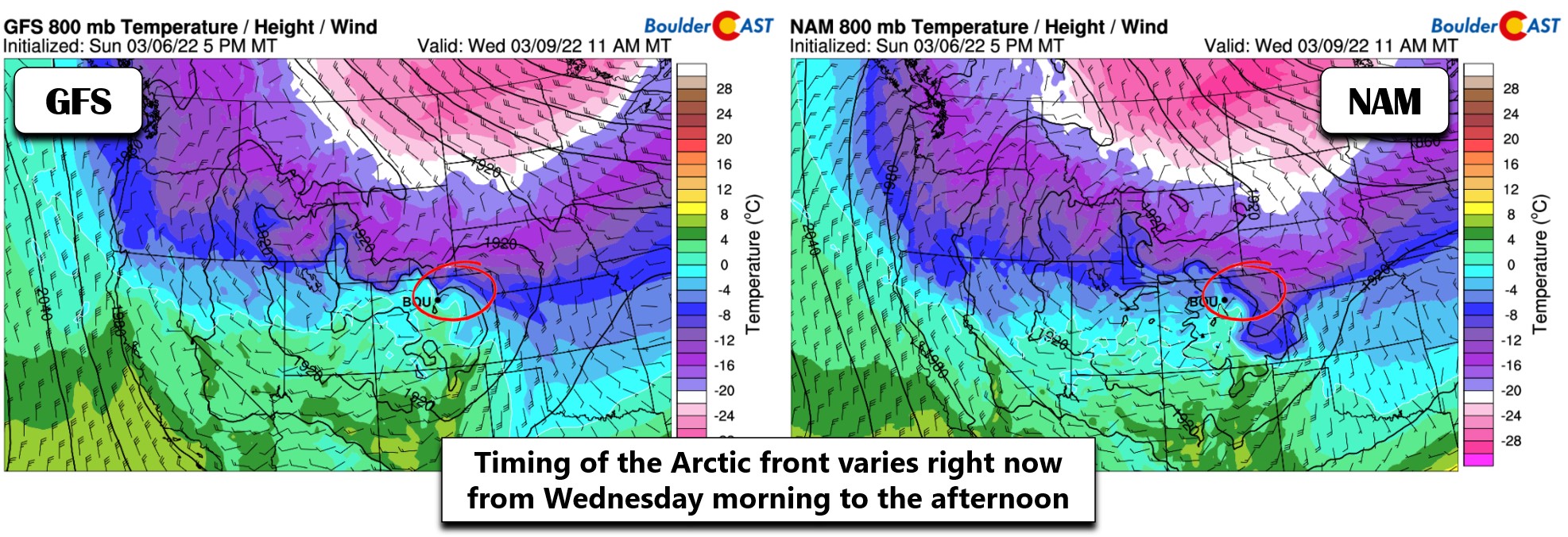
Models have been consistently showing this Arctic airmass engulfing eastern Colorado for many days now. However, the trend over the last several model runs has been to speed up its arrival. We now believe that the surface cold front could arrive as early as Wednesday morning, or as late as Wednesday afternoon. This will of course wreak havoc on the temperature forecast for the day. Considering the fast model trends, for now plan on a milder Wednesday morning in the lower 30’s with temperatures falling off a cliff through the day into the 20’s and teens rather quickly.
We do expect a period of snow to accompany this Arctic front across the Front Range. The key things to watch for Wednesday’s winter weather will be:
- Possible freezing drizzle at the onset: There may be a several hour window during the day Wednesday where a shallow saturated layer sets up over the Front Range spawning freezing drizzle. Eventually (and rather quickly) temperatures plummet far enough to change everything over to snow for us. It’s unclear if the drizzle ingredients will really materialize or not, but it seems possible at the moment.
- The overhead jet stream: The jet stream will be sliding across Colorado Wednesday afternoon and evening potentially spawning a few jet-forced heavy snow bands. Eastern Colorado will be in the favorable left exit region of the jet. Right now it doesn’t look to be a major player for us with potentially most of the activity southeast of Denver, but it is still something to watch for at least a brief chance at heavy snow with this event.
- Cold temperatures aloft with a deep dendritic snow growth zone: Temperatures drop quickly Wednesday into Wednesday night into almost a perfect setup for dendritic snowflakes to form. This will mean very high snow ratios for this event, 15:1 or higher, which will help to boost snowfall totals across the region
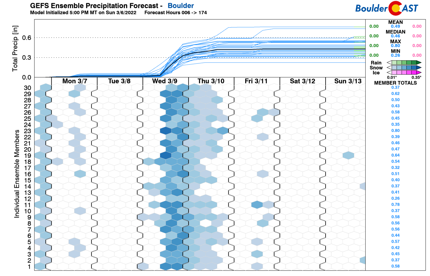
Outside of any lingering jet-forced snow bands, snowfall amounts Wednesday into Thursday look to land in the 3 to 8″ range for the Denver Metro area with the highest amounts focused west of Interstate 25. Our latest snowfall probabilities show nearly a 100% chance of at least 4″ in Boulder, but only a 10% chance to exceed 8″. Hope you’re ready for more white stuff!
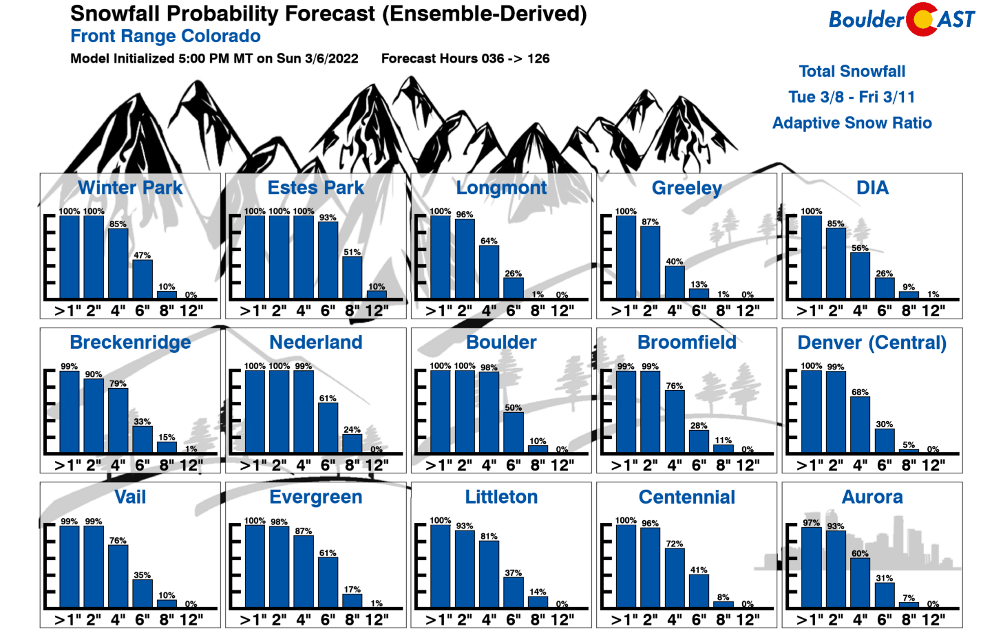
These snow amounts would contain around 0.45″ of moisture for Boulder — the ensemble spread is showing 0.3″ to 0.6″ is possible Wednesday into Thursday.
The timing on everything right now would suggest the following for Wednesday: a mild-ish morning in the lower 30s, rapidly tumbling temperatures, increasing upslope flow, developing low clouds, possible freezing fog and drizzle transitioning to snow by afternoon or evening. There is some potential for a few heavy snow bands, but that appears to be a minor factor with this event. Snow is most likely across the Front Range Wednesday afternoon through Thursday morning. Depending on the exact timing of things, we could be looking at a slow evening commute on Wednesday, then with a slick Thursday commute looking extremely likely. Snow should come to an end by Thursday late morning or early afternoon. Thursday will be a bitter cold day across the area — look for daytime highs only in the teens for Boulder and Denver, some 40 degrees below normal!
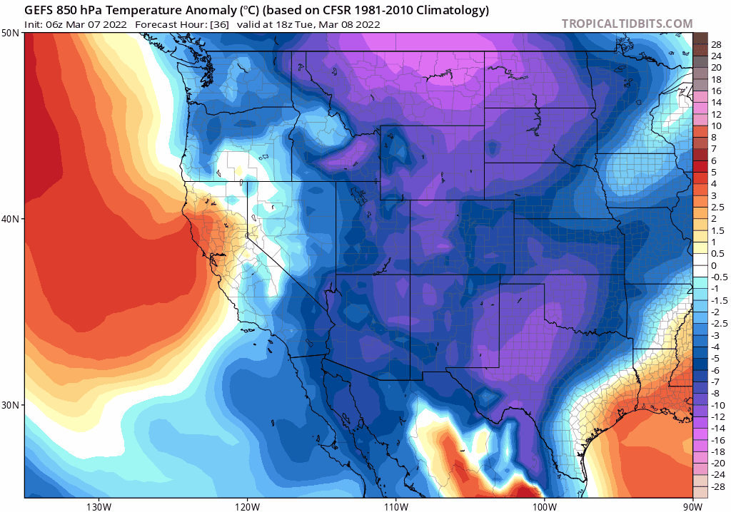
GFS ensemble mean near-surface temperature anomaly forecast animation from Tuesday through Friday. Note the several pulses of extremely cold air dropping out of Canada.
With skies clearing out late Thursday, the focus then turns to the very cold temperatures expected for Friday morning. Most areas will probably drop close to zero or even below zero Friday morning. The daily record low for Boulder on Friday (March 11th) is -9°F set back in 1932. Will it be that cold? Probably not, but plan for a brisk morning with sub-zero wind chills! Highs on Friday will only be in the 20’s. We are tracking a secondary Arctic surge around the Friday timeframe. For better or worse, this secondary Arctic push looks to just miss Colorado to the east. Temperatures warm back to near, or dare we say above, normal during the upcoming weekend.
We’ll be fine-tuning our forecast in the coming days for the late-season Arctic outbreak arriving on Wednesday with accompanying snowfall, so check back for updates. Have a good week!
Stay up to date with Colorado weather and get notified of our latest forecasts and storm updates:
Forecast Specifics:
Monday: Sunshine early, then partly cloudy with a very slight chance of late-day snow showers, mainly south of Denver. Highs in the lower 30s on the Plains with low 20s in the Foothills.
Tuesday: Partly cloudy, dry and still chilly with highs in the lower 40s on the Plains and upper 20s in the Foothills.
Wednesday: Deteriorating conditions with highs around freezing in the morning with falling temperatures through the day. There may be a period of freezing drizzle before snow develops in the afternoon and evening. Snow could be heavy at times and continues through Wednesday night.
Thursday: Bitter cold with lingering light snow in the morning. Some sun possible later in the day. Highs in the middle teens across the Plains and in the single digits in the Foothills.
Friday: Mostly sunny, cold and quiet with highs in the 20s across the Plains with teens in the Foothills.
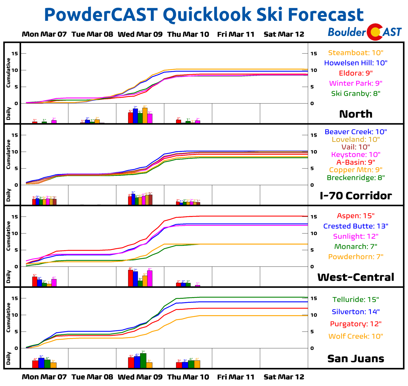
Mountains: Cold temperatures will be present across the Mountains all week with below zero temperatures in many areas much of the time. Monday will offer widely scattered snow showers with generally 1″ or less of accumulation. Tuesday will be mostly quiet. The Arctic blast on Wednesday across the Plains will instead be a somewhat favorable orographic snow-maker in the High Country with westerly flow and some embedded moisture. We expect many ski resorts to pick up 5-8″ Wednesday into Thursday before things clear out and turn quiet (but windy) on Friday.
Help support our team of Front Range weather bloggers by joining BoulderCAST Premium. We talk Boulder and Denver weather every single day. Sign up now to get access to our daily forecast discussions each morning, complete six-day skiing and hiking forecasts powered by machine learning, first-class access to all our Colorado-centric high-resolution weather graphics, bonus storm updates and much more! Or not, we just appreciate your readership!
Spread the word, share the BoulderCAST forecast!
he ove


You must be logged in to post a comment.