
This week’s weather will feature a resurgence of winter across the Front Range, but in typical fashion it will be immediately preceded by a few days of spring-like conditions including potentially our first 70-degree day of 2023. The bottom is set to fall out Wednesday night with rain changing to wet snow across the region. Though there is still some uncertainty due to the lead time, accumulating snowfall looks very likely for almost everyone in the Metro area. Read on for our complete outlook of the weather week ahead.
This week’s highlights include:
- The warmest temperatures yet in 2023 arrive as strong southwest flow pumps in the warmth — Denver could hit 70 degrees Wednesday
- Yet another remnant atmospheric river will reach Colorado midweek producing heavy snowfall in the Mountains with 1 to 3 feet slamming the San Juans
- A cold front will move across the lower elevations Wednesday night with rain changing to wet snow — snow could be heavy at times
- Accumulating snow is likely with this event in the Metro area
- Thursday will be nearly 40 degrees colder than Wednesday
- The week ends quiet but cold on Friday
DISCLAIMER: This weekly outlook forecast is created Monday morning and covers the entire upcoming week. Accuracy will decrease as the week progresses as this post is NOT updated. To receive daily updated forecasts from our team, among many other perks, subscribe to BoulderCAST Premium.

Hello spring!
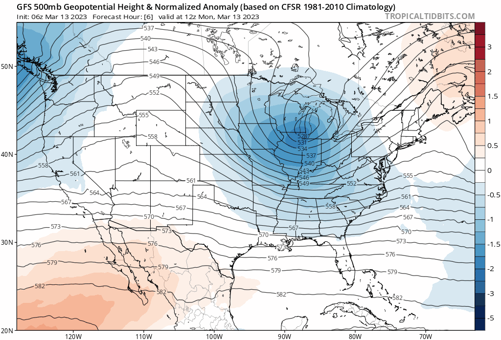
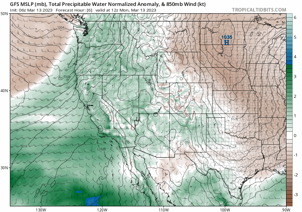
Though there have been a couple springlike days mixed into the first two and a half months of 2023, they have been rather few and far between for the most part with below normal temperatures dominating our weather since around early November. It was the coldest winter since 2010 after all! That changes (somewhat) this week with a broader ridging pattern taking hold over the Rockies and Great Plains through the first few days of the week. The GFS 500mb height anomaly forecast animation below takes us through midweek. Notice how the ridge develops over Colorado before shifting to the east. This setup will initiate a pleasant surge of warm air from the southwest which will push Front Range temperatures to their highest values yet in what has been a definitively cold 2023 thus far.
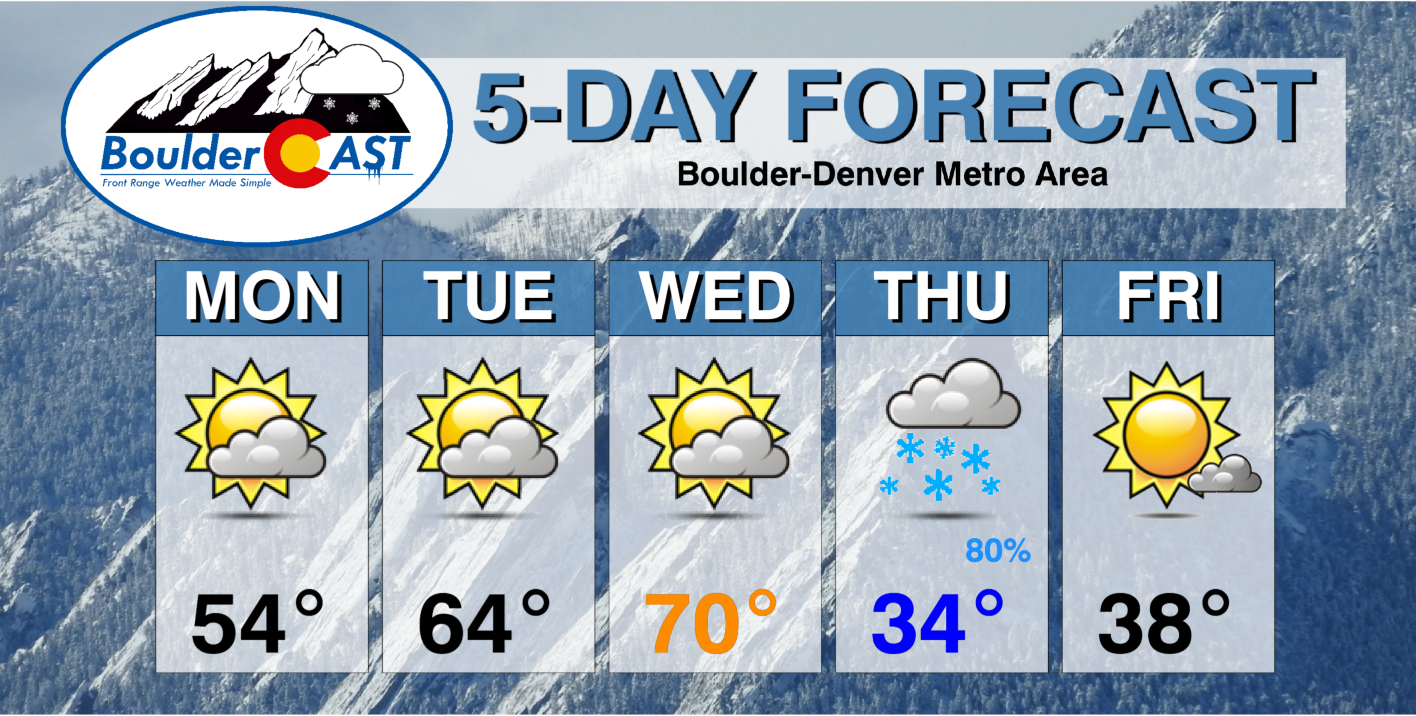
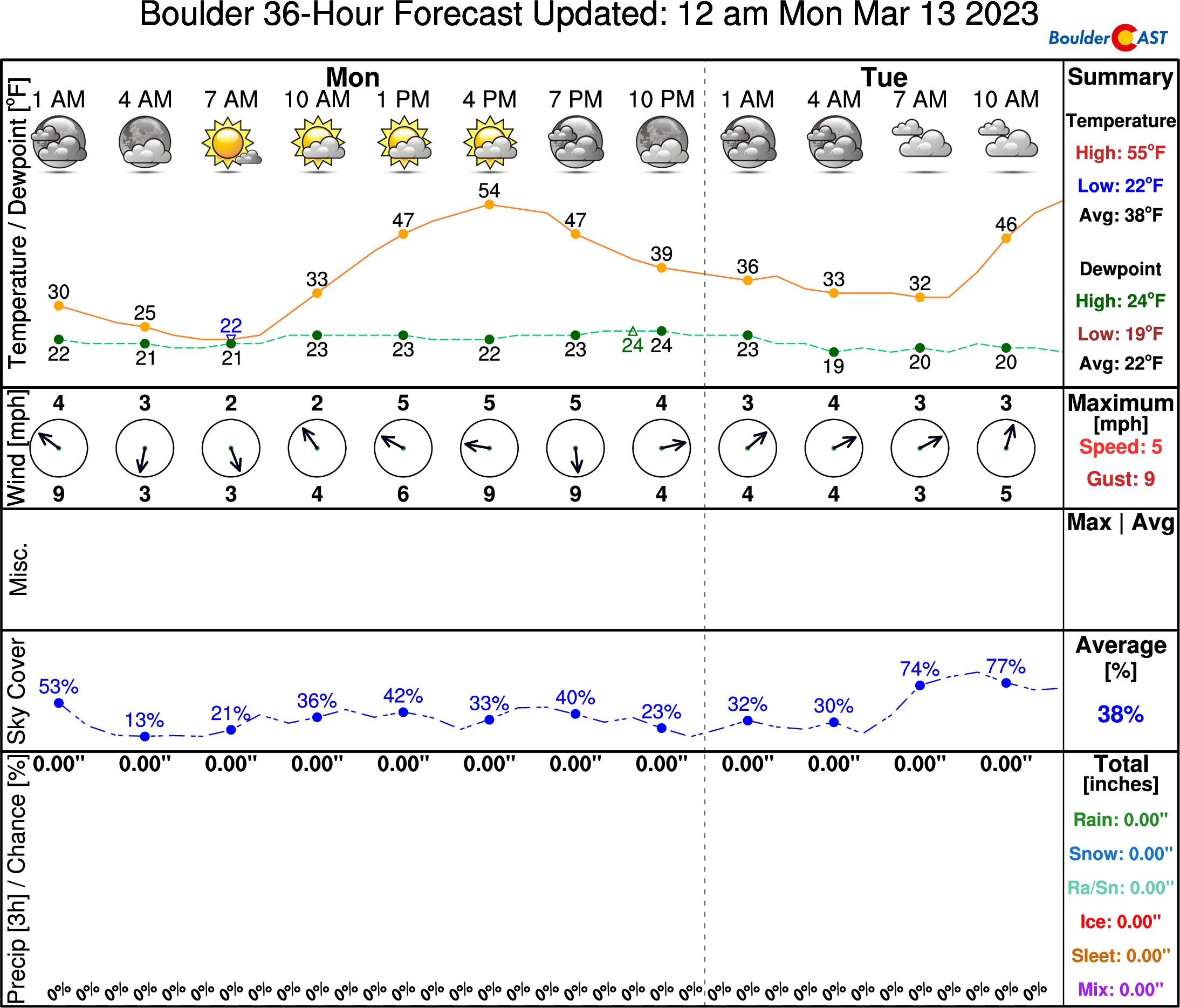
After that chillier day we had on Sunday, Monday will kick off our warming trend with high temperatures getting into the middle 50s around Boulder and Denver under partly sunny skies.
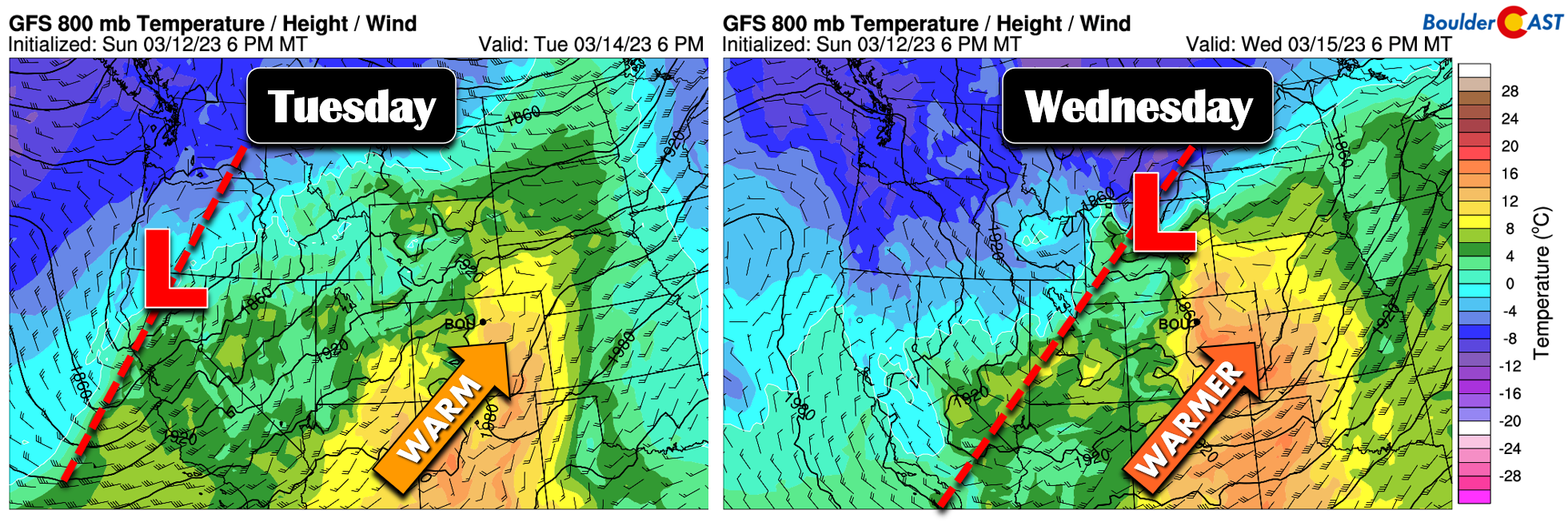
The temperature dial ramps up further by Tuesday and especially on Wednesday as a lee thermal trough becomes established over the area in response to the persistent southwesterly downslope flow. Temperatures are expected to “soar” into the 60s on Tuesday and potentially into the lower 70s by Wednesday. Wednesday is indeed shaping up to be the warmest day of the week, and in fact the warmest day since early November for us.
There will be some wind associated with the warmth Tuesday and Wednesday, but nothing too bad in our area. It may be gusty on Wednesday and with low humidity, but Red Flag conditions are not expected at this time owing to winds staying on the lower end of the spectrum.
A wet Pacific system hammers Colorado Wednesday into Thursday
As you can probably glean from the graphics so far, our spring warmth will be cut short by an approaching Pacific trough from the west. Our next storm system moves in by Wednesday evening/night and it will include another moisture-packed atmospheric river with ties back to the tropics in the central Pacific Ocean. The focus for this latest in a slew of atmospheric rivers will be across central/southern California which can expect more flooding rains and up to seven feet of snow in the higher terrain. Drought is all but a distant memory in the Golden State for now, despite the everlasting issue of water availability for an overpopulated region that relies so heavily on out-of-state H2O…

The residual moisture from this atmospheric river will push across Colorado early Wednesday through Thursday producing another round of heavy snow in our Mountains.
As usual for these type of events infused by the subtropical jet stream, the focus for the heaviest snow this week will be across southwest Colorado Wednesday into Thursday morning where orographics will be best — 1 to 3 feet of new snowfall is in the cards for the San Juans. The northern Mountains and Interstate 70 ski resorts will be less favored by this flow direction, but they should also pick up decent snowfall this week — perhaps 4 to 12″ or so.

As you can see above, there is also some snow in the works for the Denver Metro area this week! However, what unfolds east of the Mountains in these situations is always a trickier forecast, but things do indeed appear to turn wet and snowy in our neck of the woods as well. A cold front will drop across the area Wednesday evening and night bringing much colder temperatures and moist upslope flow on the backside. The current timing on the front is between 6PM and midnight on Wednesday.

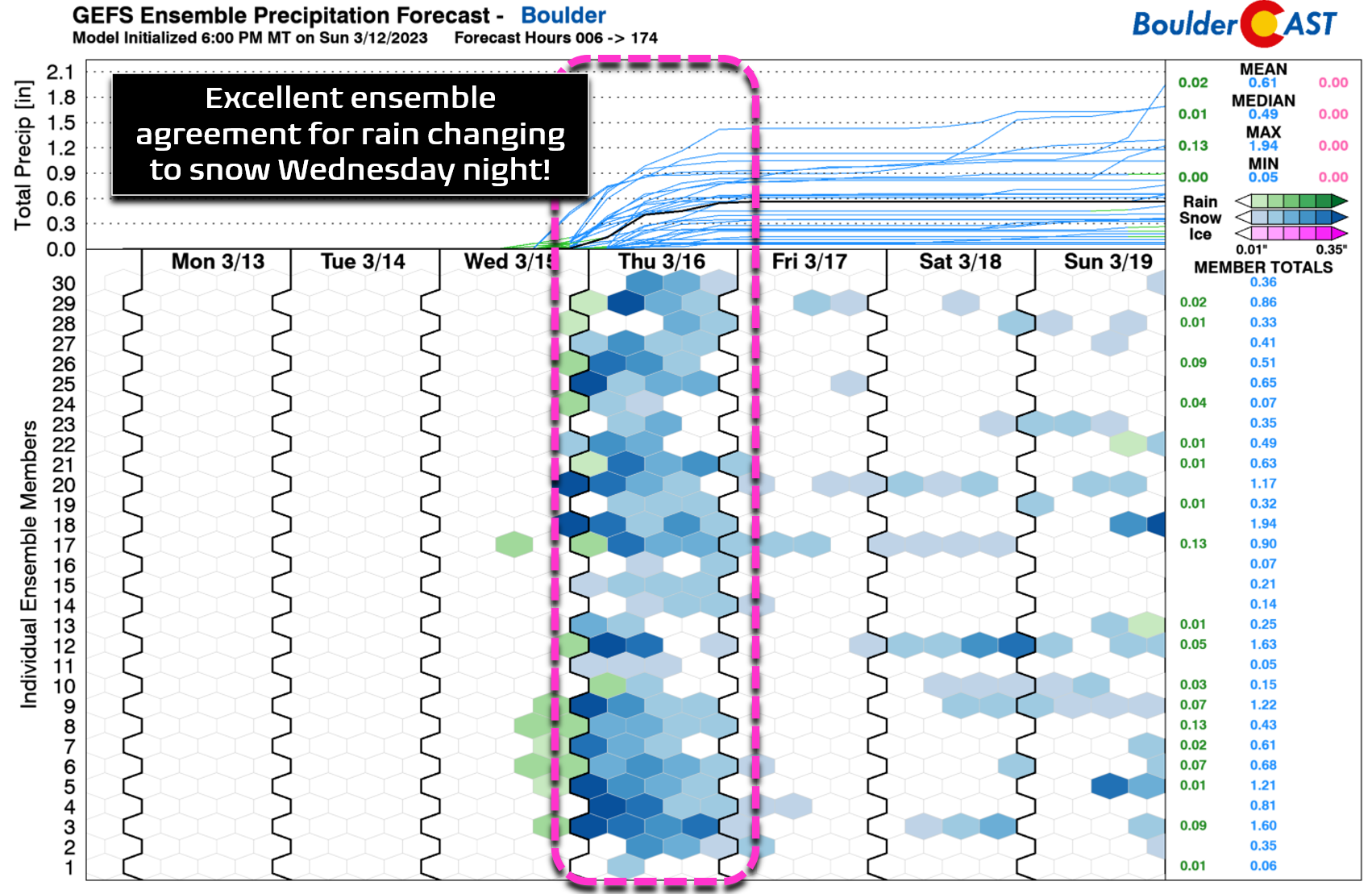
Unlike the last few weeks which have had only minor chances for precipitation as storm systems passed generally too far to our north, this week’s Front Range rain/snow event is all but confirmed at this point with strong model support across the board. With that point out of the way, precipitation for us may begin as rain Wednesday night but should turn to snow after midnight and before sunrise Thursday as the chill of winter returns. There will likely be a swath of heavier rain and snow following the frontal passage as the best frontogenesis moves through the area with some instability as well. There could be 1 to 2″ per hour snowfall rates around early Thursday with potential impacts on the morning commute. Keep in mind the timing of everything is still a bit up in the air, but the worst of the snow looks to be lining up late Wednesday night into Thursday morning. The fact that it will have been 70 degrees Wednesday afternoon may help keep roadways just wet, at least across the lower elevations.
After the strong frontal forcing moves through, lingering north and northeasterly upslope through the day Thursday should keep light snow going, particularly south and southwest of Denver. Elsewhere, snow will be fairly light through the day with temperatures warming up into the middle 30s. Above freezing temperatures and the mid-March sun should help mitigate any travel issues with just wet roads through the day and for the Thursday evening commute.
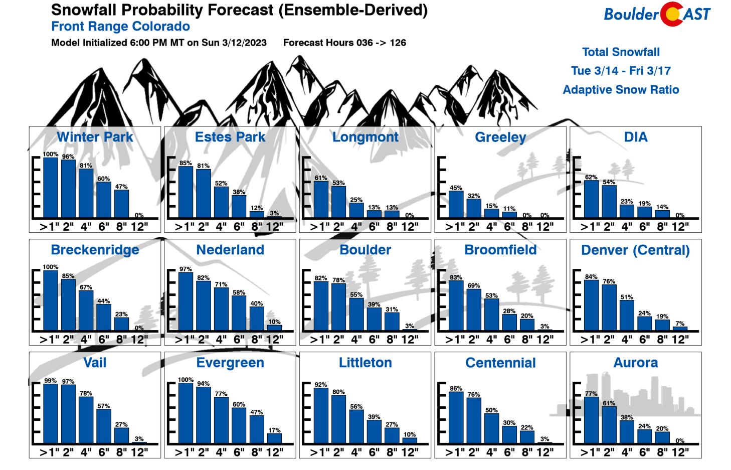
As for potential accumulations, we expect that most areas will pick up a few inches of wet snow from this storm. Our gut feeling has this as a 1 to 5 inch type of event for many, with higher totals possible in and near the Foothills and Palmer Divide with lower totals up north and out east. Our latest Snowfall Probabilities should give you an idea of the snowfall potential in your location — though the spread is still a bit broad as models are yet to narrow in on a definite solution. That’s about as specific as we want to get with this snow event for now — it’s still ~72 hours away after all!
The week will end cold but quiet as dry northwest flow takes over statewide. Expect highs on Friday to reach near 40 degrees with mostly sunny conditions. We’ll likely be providing more details on the mid-week (snow)storm in the coming days — do check back.
Forecast Specifics:
Monday: Partly cloudy and seasonal with highs in the middle 50s on the Plains and in the lower 40s in the Foothills.
Tuesday: Morning sun but increasing clouds through the afternoon and evening. Warmer with highs in the lower 60s on the Plains and in the upper 40s in the Foothills.
Wednesday: Partly to mostly cloudy and very warm with highs nearing 70 degrees across the Plains and into the middle 50s in the Foothills.
Thursday: Much colder with widespread snow likely, heaviest during the morning hours. Several inches of accumulation will be possible with this system. Daytime highs will only reach the low to middle 30s with overcast skies and light snow lingering across the area. The Foothills will see highs only in upper teens and 20s.
Friday: Drying out but staying cold under partly to mostly sunny skies. Temperatures stay well below normal with highs only in the 30s across the Plains and in the 20s in the Foothills.
PowderCAST: As the moisture plume approaches, heavy snow will develop in the Mountains beginning Tuesday night and continues into Wednesday night. Snow will be heaviest across south and southwest Colorado which are much more favored by southwesterly moist flow. Lesser snowfall totals are expected in the northern and central Mountains. Snow comes to an end for the most part in the Mountains Thursday afternoon with Friday looking fairly dry statewide though with colder than normal conditions remaining.

Help support our team of Front Range weather forecasters by joining BoulderCAST Premium. We talk Boulder and Denver weather every single day. Sign up now to get access to our daily forecast discussion email each morning, complete six-day skiing and hiking forecasts powered by machine learning, first-class access to all our Colorado-centric high-resolution weather graphics, bonus storm updates and much more! Or not, we just appreciate your readership!
Spread the word, share the BoulderCAST forecast!


You must be logged in to post a comment.