The weather this week in the Front Range will have two contrasting primary themes. A heat dome cooking beneath a large ridge of high pressure off to our southwest will push temperatures towards record highs Monday and Tuesday. However, the rest of the week will exhibit a cooling trend with increasing chances for late-day thunderstorms as several backdoor cold fronts team up with increasing monsoonal moisture. Yes, the famed monsoon season is about to commence! In typical fashion though, there will also be a risk of some severe weather mixed in. Let’s take a look at what should be yet another interesting weather week…
This week’s highlights include:
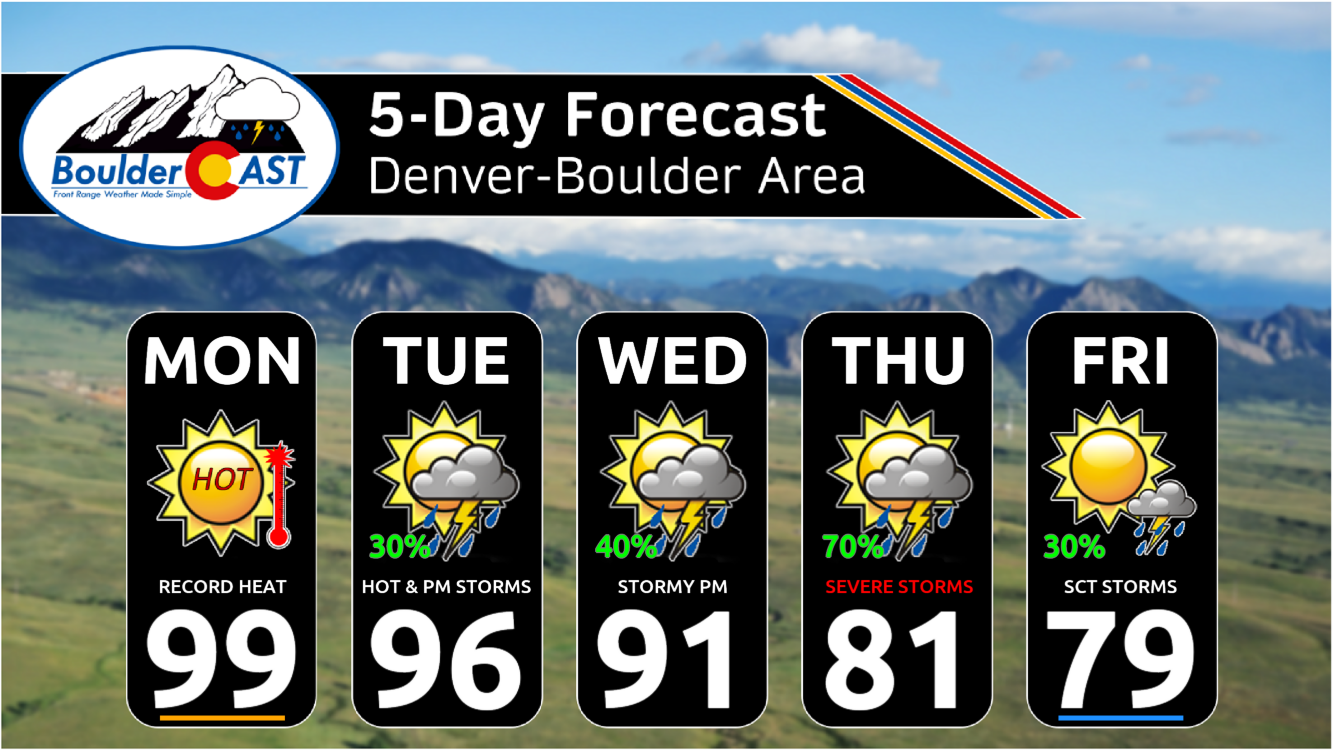
- A massive heat dome will slide into Colorado early in the week from the southwest bringing dangerous record high temperatures to the area nearing 100 degrees on Monday and Tuesday
- Monsoonal moisture and weak cold fronts will team up to bring cooler temperatures and increasing chances for thunderstorms as the week progresses
- Severe storms may be possible on Thursday with large hail, a few tornadoes and very heavy rainfall
- Temperatures cool off each day this week, eventually ending up comfortably around 80 degrees for Thursday and Friday
- Rainfall chances decline on Friday as drier air enters the area and that trend will continue into the upcoming weekend, though a few storms will linger
DISCLAIMER: This weekly outlook forecast is created Monday morning and covers the entire upcoming week. Accuracy will decrease as the week progresses as this post is NOT updated. To receive daily updated forecasts from our team, among many other perks, subscribe to BoulderCAST Premium.

Go Premium, get all the perks.
Daily Forecast Updates
Get our daily forecast discussion every morning delivered to your inbox.
All Our Model Data
Access to all our Colorado-centric high-resolution weather model graphics. Seriously — every one!
Ski & Hiking Forecasts
6-day forecasts for all the Colorado ski resorts, plus more than 120 hiking trails, including every 14er.
Smoke Forecasts
Wildfire smoke concentration predictions up to 72 hours into the future.
Exclusive Content
Weekend outlooks every Thursday, bonus storm updates, historical data and much more!
No Advertisements
Enjoy ad-free viewing on the entire site.
Making a run at 100° Monday
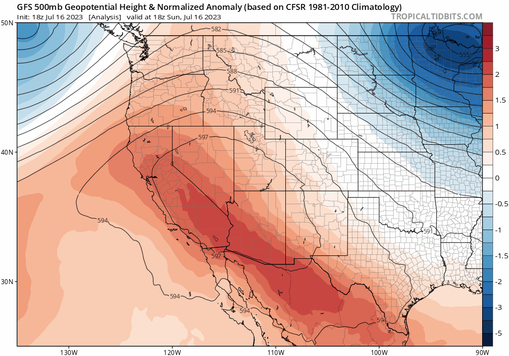
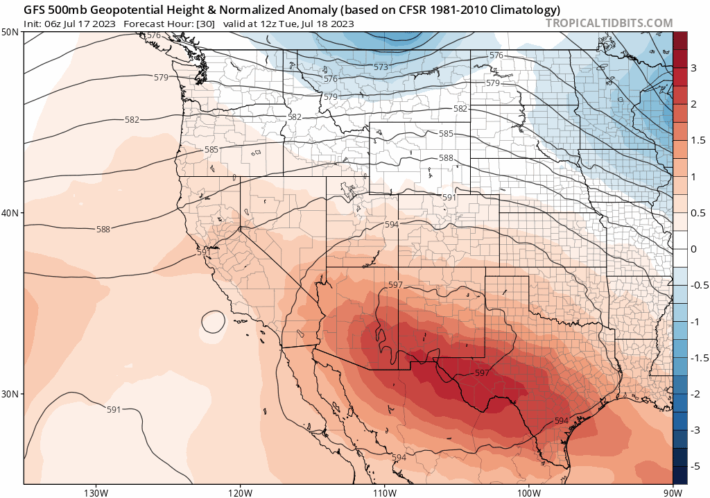
Monday will be the hottest day of the week as the massive heat dome across the southwestern United States drifts slightly eastward to encompass most of Colorado. The GFS 500mb height anomaly animation below shows the ridge’s migration from Sunday through Monday night. Notice how it slides from near Las Vegas into New Mexico during this time. As it heads eastward, so too will its scorching temperatures!
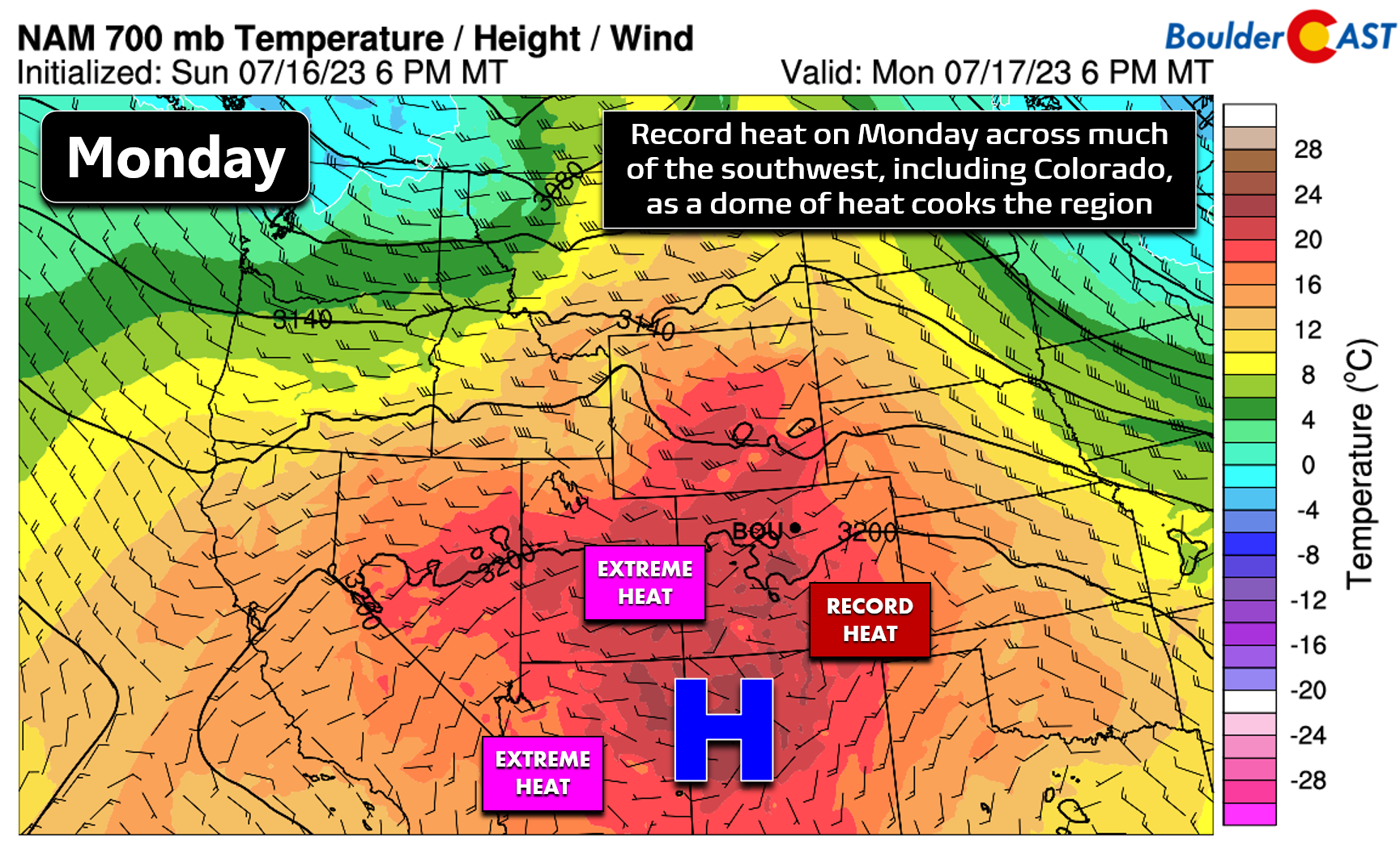
Monday is expected to be the hottest day of the week in the Denver area as 700mb temperatures climb above 20°C under this very hot dome of air, about 4°C warmer than it was on Sunday.
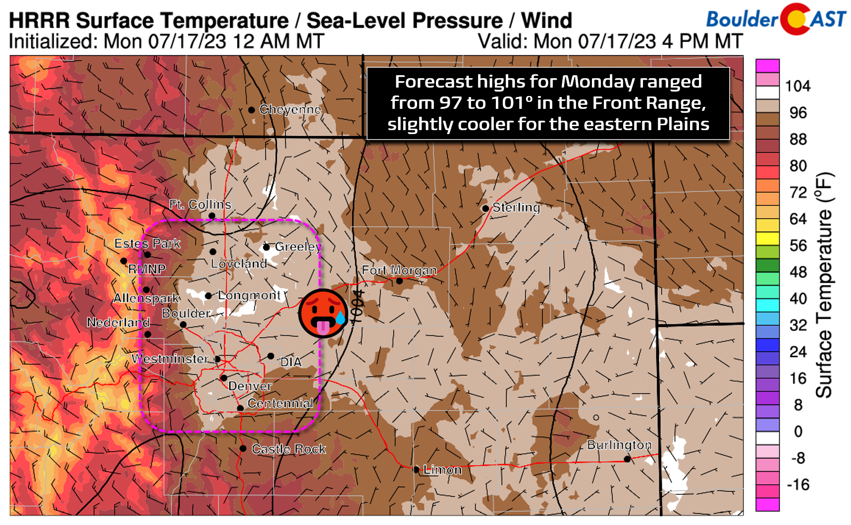
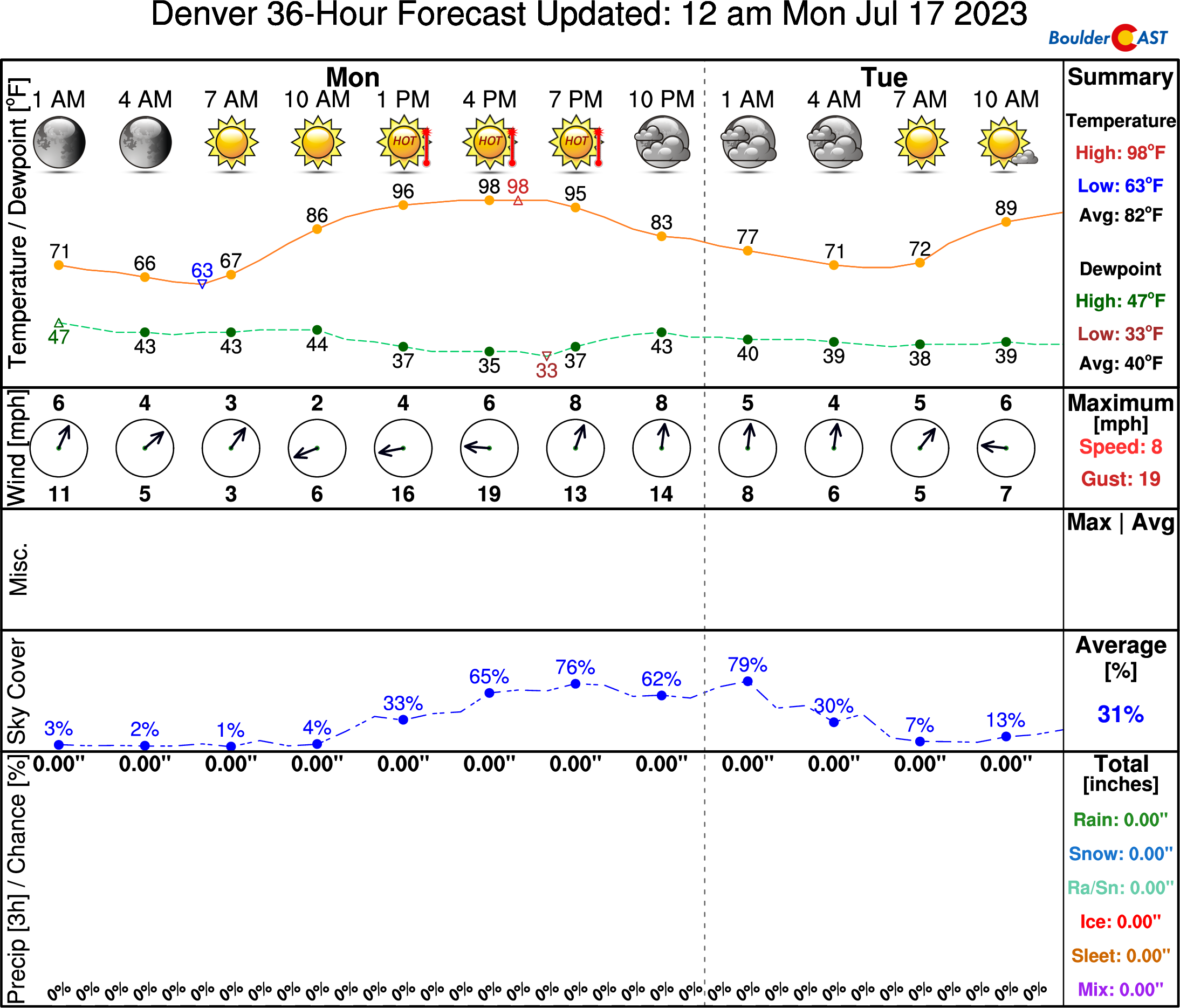
This warm day aloft will translate to temperatures in the upper 90s to right around 100 degrees at the surface in the Metro area — definitely the hottest day thus far in 2023 for everyone and potentially the first triple-digit reading in some of the more “oven-favored” locations such as Longmont and Greeley. The map below is the HRRR model temperature forecast for 4:00PM Monday. Toasty indeed!
Monday will see plentiful morning sunshine lingering into the afternoon before clouds move off the terrain and a few convective showers try to develop. We could see one or two weak thunderstorms pop over the higher terrain, but broadly most everyone should remain dry with heat the main focus.
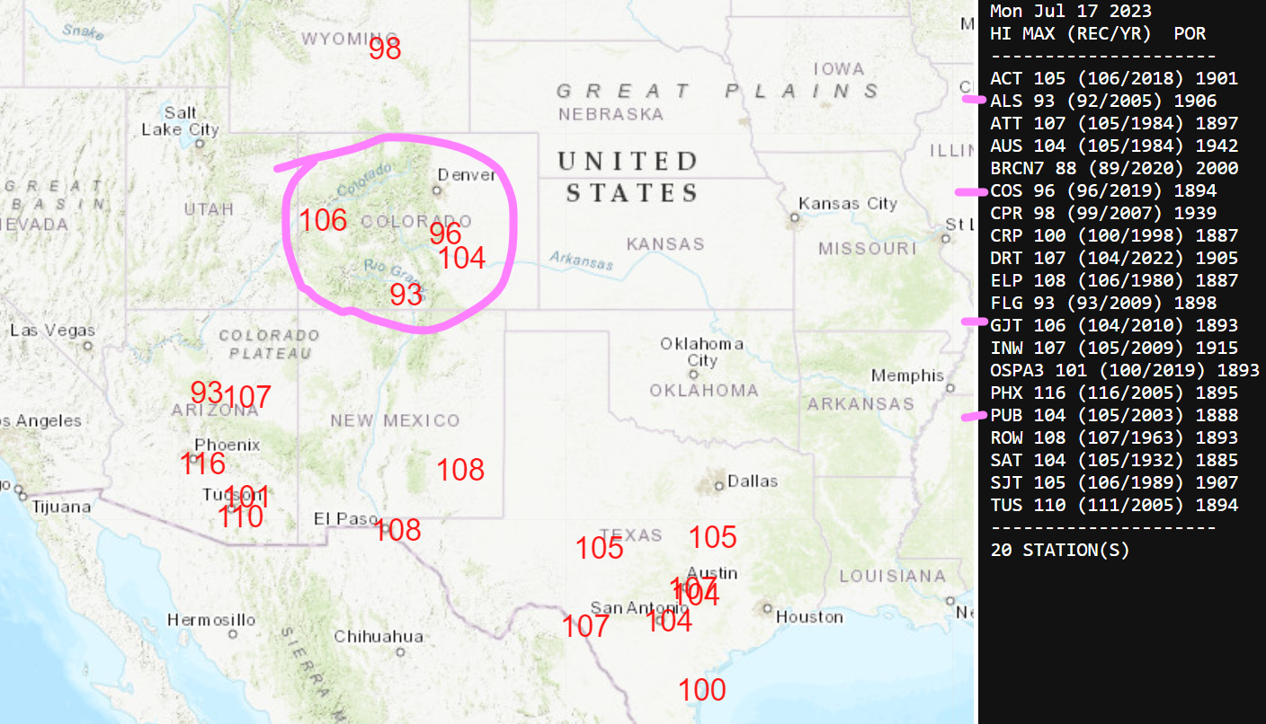
July 17th actually has some of the weakest existing high temperature records for the entire month of July in our area. Upper 90s to near 100 degrees will put us in decent shape to likely set new daily record highs on Monday. For example, the existing record value in Boulder is just 98° set back in 2010 (among other years). We have an excellent chance to at least tie this record if not break it by a degree or two.

Other cities across Colorado possibly setting new daily records on Monday include Grand Junction (106°), Pueblo (104°), Colorado Springs (96°) and Alamosa (93°).
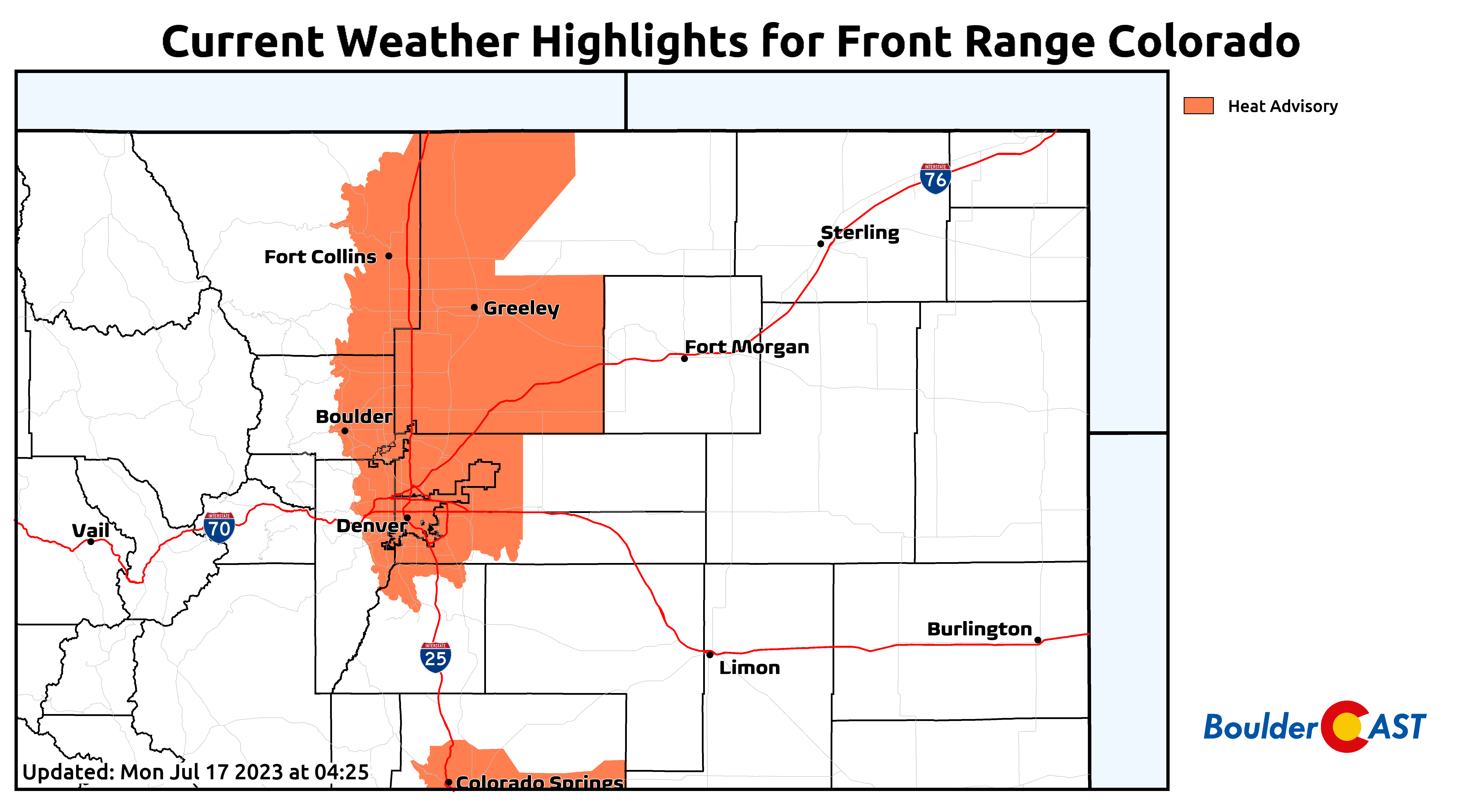
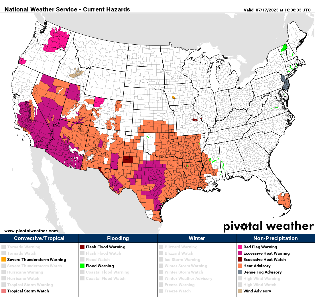
With Monday’s heat near the high end of climatology, it’s of course no surprise that Heat Advisories are in effect across the Front Range (following the “heat risk” rule change in 2022). Heat indices will be in the mid to upper 90s across the area on Monday. Remember, the heat index (i.e. the “Feels Like” temperature) is actually lower than the real temperature here due to our low humidity which allows for rapid evaporation of sweat.
The heat dome will continue to affect a large portion of the southwestern United States early this week. The Front Range is really only on the northern fringe of things and will see just one or two days of (regionally) extreme heat. Other places in the Desert Southwest have been hitting 110 to 130°F consistently the last several days and will continue to do so much of the week.
Monsoon moisture increases Tuesday and beyond
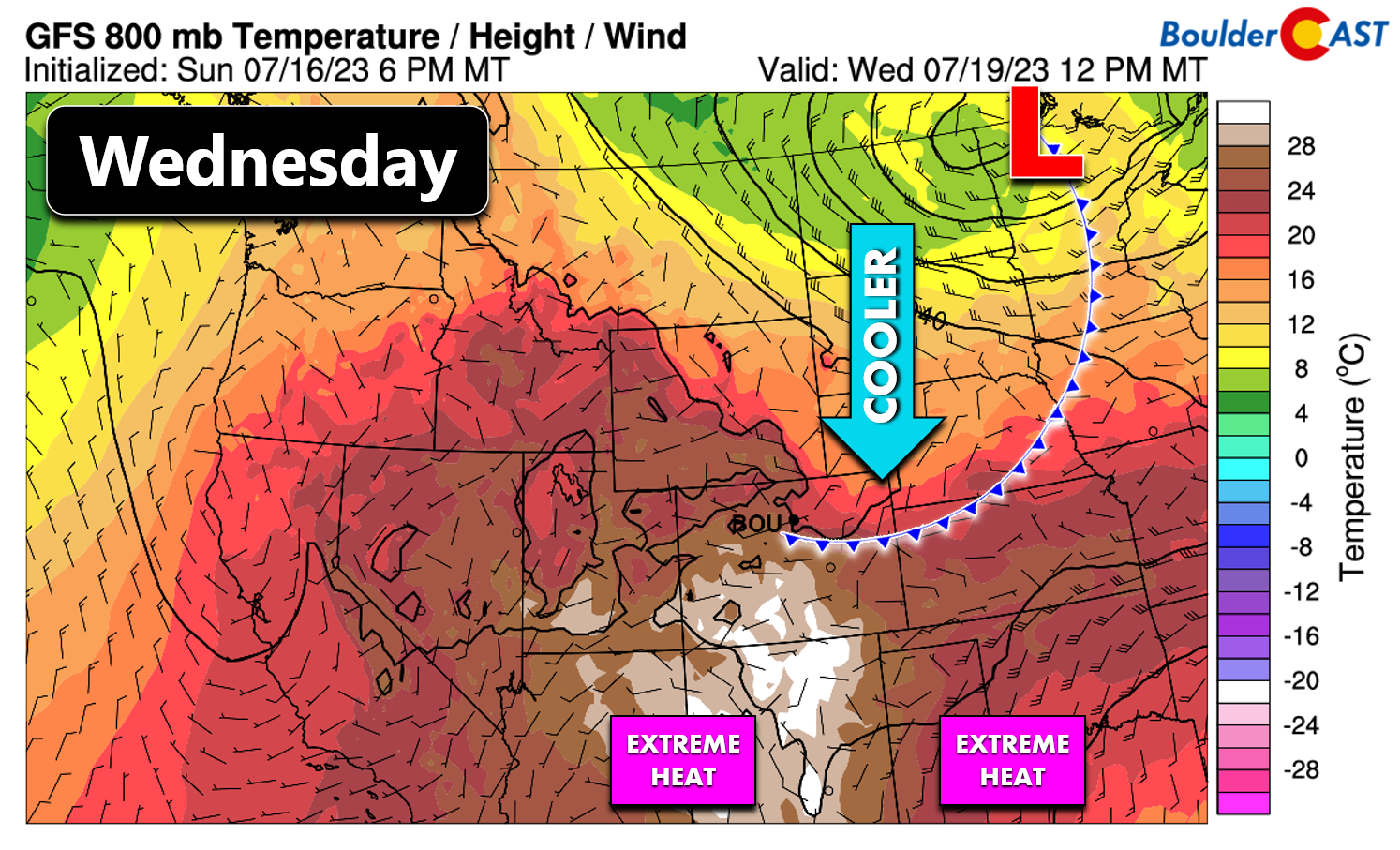
As mentioned earlier, the hottest day of the week is expected to come on Monday. This is because the eastward shift of the ridge is likely to reverse the rest of the week, with the high pressure center drifting back southwestward, in addition to it getting beaten down slightly by shortwave disturbances trekking along the Canadian border. The migration is subtle, but by the latter part of the week our area will end up back under northwesterly flow aloft.
This shift to northwesterly flow will allow several backdoor cold fronts to slide into northeast Colorado tied to those systems traversing along the Canadian border. One of these fronts is forecast to show up on Wednesday and is shown below. These fronts will increase low-level moisture (and thus instability) across the area, as well as provide subtle upslope forcing — both of which will help initiate thunderstorm development for us.
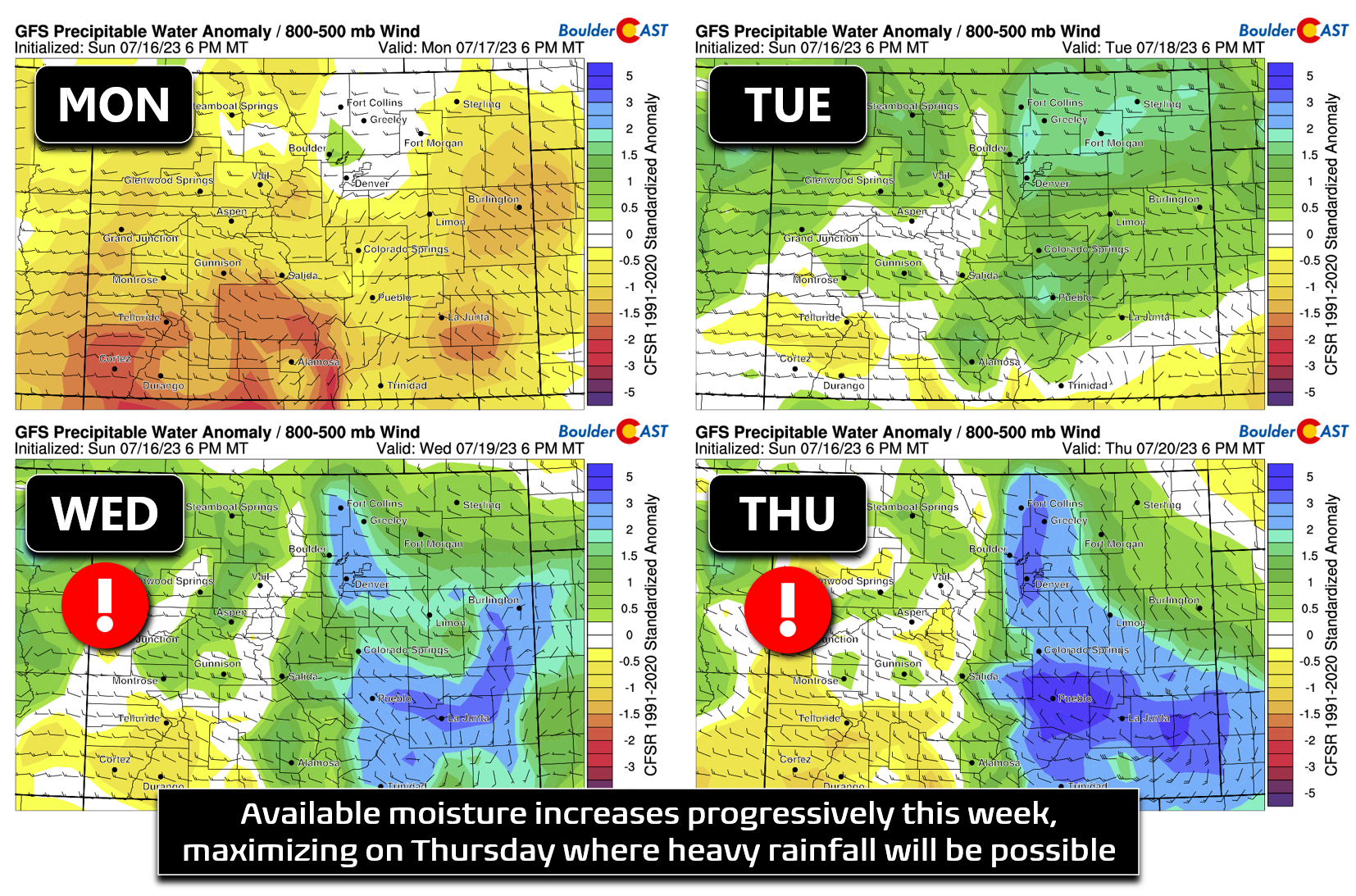
In concert with the surface cold fronts, monsoonal moisture will also be on the increase Tuesday through Thursday from the west and northwest supplying additional juice for thunderstorm growth. The GFS moisture anomaly forecast animation below shows the trajectory of the monsoon moisture moving in this week — first pushing northward into California/Nevada and then eastward across Salt Lake City into Denver. We talked in great detail about the arrival of the monsoon in a recent post, including how it’s coming exactly on time (and not late as is a common misconception). Please check out that post for more details on Colorado’s 2023 monsoon, as we only brush on the topic here.
Precipitable water values will climb progressively each day through the week ahead — going from rather dry on Monday to downright soupy by Wednesday and especially Thursday. With this increase in moisture, thunderstorm chances will be on the rise as well each day. Look for widely scattered storms Tuesday (20%), scattered storms Wednesday (40%) and then widespread storms by Thursday (70%+).
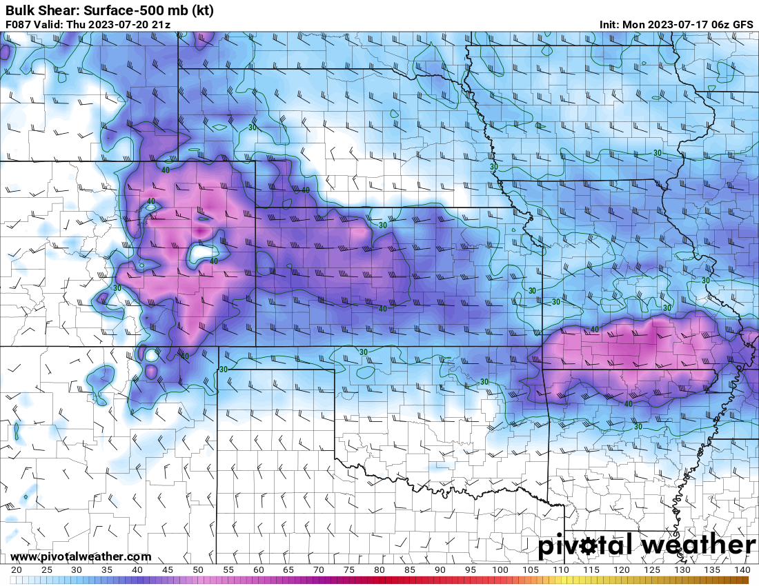
It’s still a little early to pinpoint the finer details, but some models are showing a rather active severe weather day on Thursday to accompany the excellent overall rainfall chance. In particular the GFS goes a bit bonkers with extreme instability and shear across portions of eastern Colorado. Note the 50+ knots of bulk shear present in eastern Colorado below. This would accompany potentially 1000-1500 J/kg of CAPE. Big hail would the main concern along with some tornadoes and damaging wind. The Euro model isn’t quite as severe-primed, but either way — Thursday should be our wettest day of the week. Any storms that form will be tapping into deep Gulf of Mexico and monsoon moisture and will be capable of very heavy rainfall and at least small hail. Keep an eye on the evolving severe forecast for Thursday!
As a result of the clouds, storms and stronger cold front, highs on Thursday will fall back to a much more comfortable range in the lower 80s! We’ll also need to keep an eye on how the conglomeration of smoke behaves though the week. Our late-week airmass will be sourced from portions of Canada and could contain some smoke.
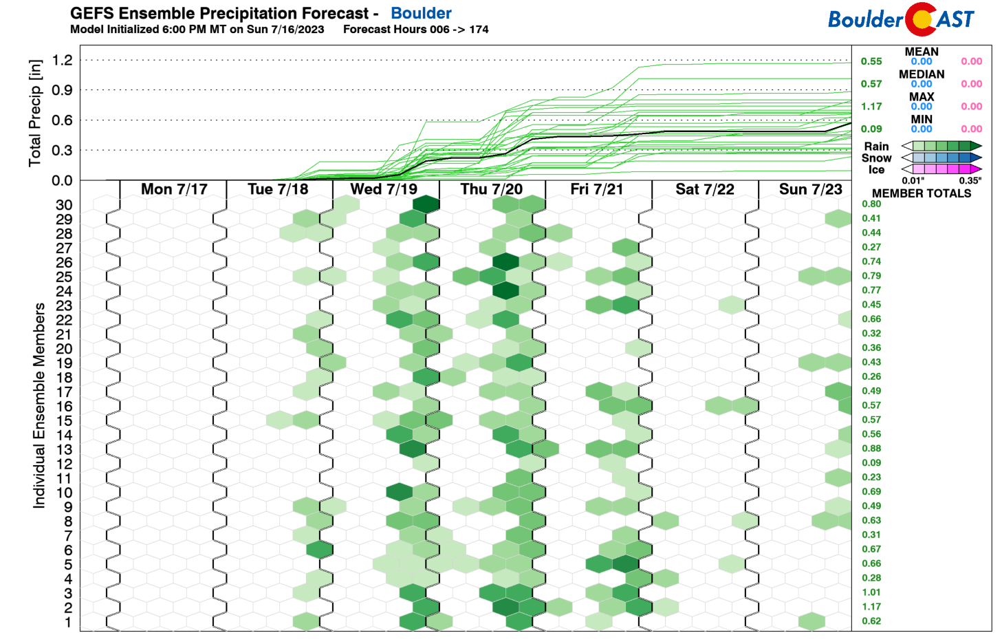
By Friday, monsoon moisture will be washing out and we’ll still be under the influence of a cooler northwest flow. High temperatures will stay around 80°F with more sunshine but still a risk of late-day scattered thunderstorms (less severe risk, but somewhat uncertain). The GFS ensemble precipitation forecast graphic below nicely shows the waxing and waning of rainfall chances this week for us.
The drying trend that begins on Friday will continue into the upcoming weekend but still there will likely be some storms around due to a small amount of lingering moisture. Temperatures will push back towards seasonal levels in the middle 80s to lower 90s for the weekend.
Stay safe, stay cool and enjoy this week’s weather!
Forecast Specifics:
Monday: Morning sun, then partly cloudy and very hot with temperatures soaring into the upper 90s to near 100 degrees across the Plains and in the middle 80s in the Foothills. Many cities will likely tie or break existing daily record highs.
Tuesday: A mix of clouds and sun. Staying hot. Scattered storms develop by late afternoon and continue through the evening and possibly into the overnight. Highs in the middle to upper 90s across the Plains with lower 80s in the Foothills.
Wednesday: Partly cloudy with scattered late-day thunderstorms. Storms will be capable of heavy rainfall. Highs in the lower 90s on the Plains with upper 70s in the Foothills.
Thursday: Likely the wettest day of the week. Some sun early, then mostly cloudy with widespread showers and thunderstorms developing, some of which could be severe with large hail and tornadoes. Storms will also produce very heavy rainfall and localized flooding. Highs cooler near 80 degrees on the Plains and in the lower 70s in the Foothills.
Friday: Staying cool and somewhat wet. Plenty of sun early, then partly sunny with scattered late-day thunderstorms. Some storms could be severe but this is uncertain. Highs reach near 80 degrees on the Plains with upper 60s in the Foothills.
DISCLAIMER: This weekly outlook forecast is created Monday morning and covers the entire upcoming week. Accuracy will decrease as the week progresses as this post is NOT updated. To receive daily updated forecasts from our team, among many other perks, subscribe to BoulderCAST Premium.
Go Premium, get all the perks.
Daily Forecast Updates
Get our daily forecast discussion every morning delivered to your inbox.
All Our Model Data
Access to all our Colorado-centric high-resolution weather model graphics. Seriously — every one!
Ski & Hiking Forecasts
6-day forecasts for all the Colorado ski resorts, plus more than 120 hiking trails, including every 14er.
Smoke Forecasts
Wildfire smoke concentration predictions up to 72 hours into the future.
Exclusive Content
Weekend outlooks every Thursday, bonus storm updates, historical data and much more!
No Advertisements
Enjoy ad-free viewing on the entire site.
Get BoulderCAST updates delivered to your inbox:
Enjoy our content? Give it a share!


You must be logged in to post a comment.