The week starts out above average with 60-degree temperatures possible over the Denver Metro area on Monday. That all comes to a halt late Tuesday as two strong cold fronts move into the region ushering in a colder and more unsettled weather pattern for mid to late-week. At the moment, we are tracking two wintry systems. Read on to find out more.
This week’s highlights include:
- Above average temperatures Monday and tomorrow in the 50s and 60s
- An Arctic cold front plows through late Tuesday night and early Wednesday, with below average temperatures the rest of the week
- A light wintry mix is possible Wednesday but impacts look minimal
- A more interesting system may take shape Friday into Saturday with a chance of light snow indicated by the guidance and ensembles

DISCLAIMER: This weekly outlook forecast is created Monday morning and covers the entire upcoming week. Accuracy will decrease as the week progresses as this post is NOT updated. To receive daily updated forecasts from our team, among many other perks, subscribe to BoulderCAST Premium.

A warm start of the week
What’s going on over the nation today? Well, it depends who you ask! Active weather continues across the eastern US, with gusty winds and wintry precipitation. Out west, quieter conditions are in place, including over our area. Colorado is largely situated between a weak jet stream over the Pacific Northwest and a low pressure off southern California. The northern jet stream has a weak embedded shortwave that will track into the Dakotas Tuesday, ushering in a cold front for our area late Tuesday and early Wednesday. More on that a little later…

As for our weather on MLK Jr. Day — it is all about the continued warm temperatures which we have experienced much of the last week thanks to ridging to our southwest and downslope flow near the surface. We should easily get into the upper 50s in most locations Monday and would expect even some lower 60s in the Denver Metro. Monday will be our warmest day of the week so you’ll want to take advantage of it if you can before colder air arrives circa midweek.

On Tuesday, we’ll see increasing clouds. The downslope warming will still be in place for the early part of the day, spelling out mild temperatures again near the low to middle 50s. However, chillier air will work in behind the first of two cold fronts, one Tuesday afternoon and another late Tuesday night into early Wednesday. The secondary front is Arctic in nature and will be the one to really usher in the colder air.

Colder beginning midweek with two shots of wintry precipitation
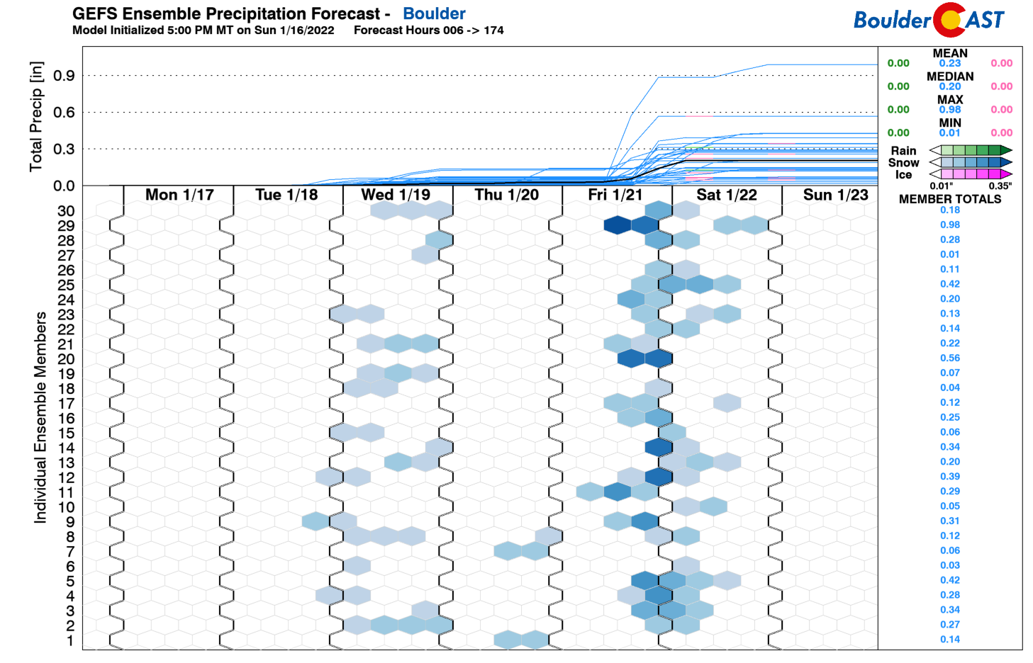
The rest of the week from Wednesday onward will feature below average temperatures along with a few chances of wintry precipitation. As you can tell in the GEFS ensemble plot below, there are hints of something on Wednesday with some members indicating snowfall. More ensemble members are indicating something more substantial for Friday. We’ll discuss a little later why this secondary wave is our best chance for snow this week!
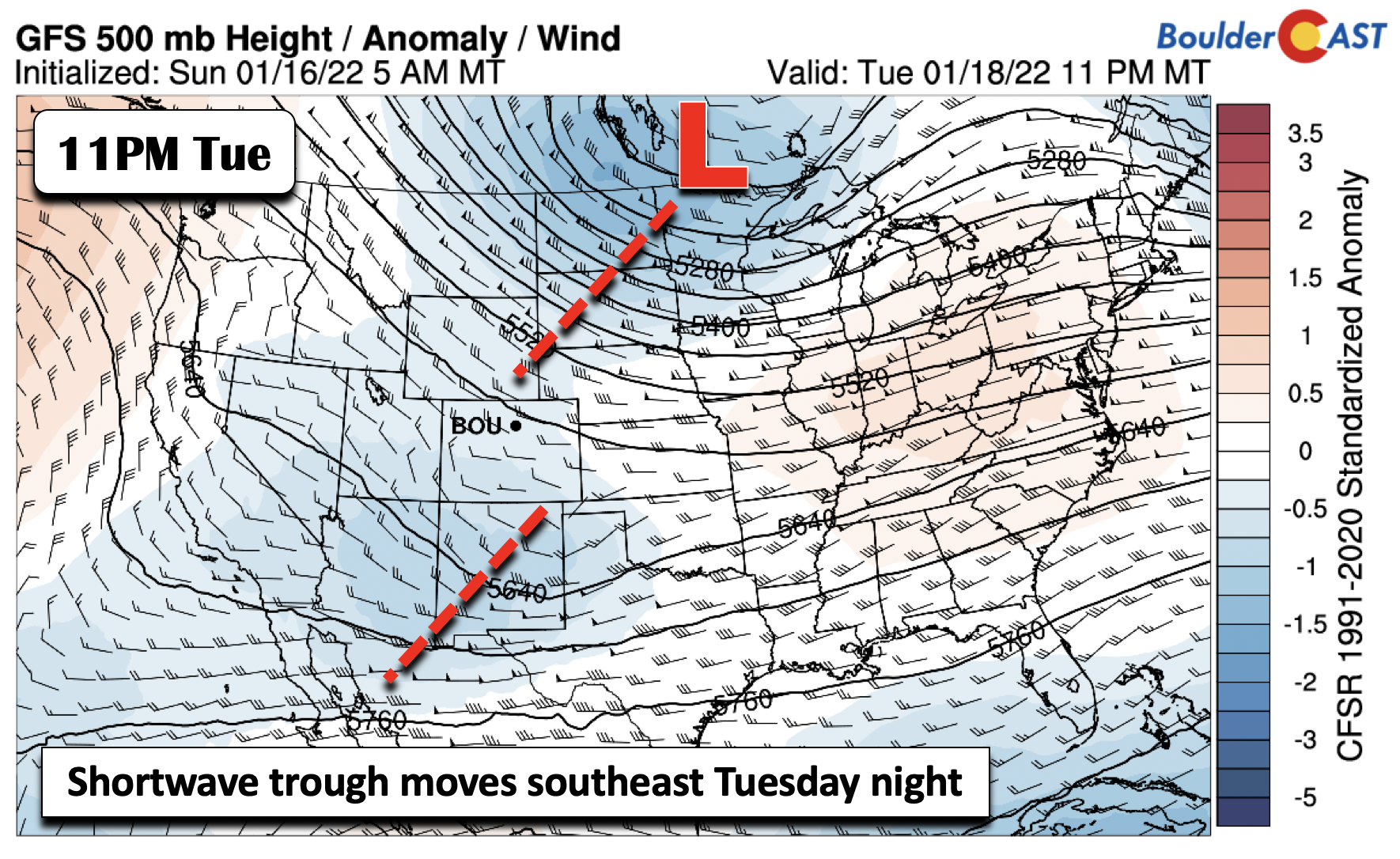
Focusing on the initial potential for wintry precipitation Wednesday — that one is connected to the Arctic cold front, as well as a shortwave trough digging into the upper Midwest late Tuesday and early Wednesday (below).
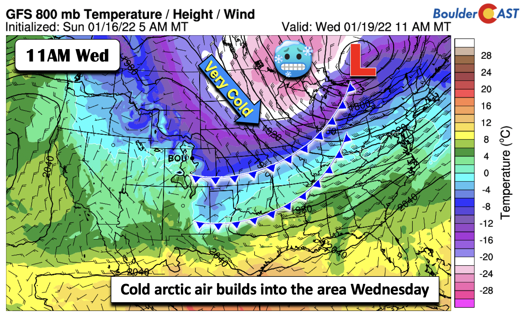
Much colder air builds in behind the front on Wednesday, but with the absolute coldest air staying over Minnesota and the upper Great Lakes region. As a result, highs on Wednesday should on top out in the lower 30s under cloudy skies.
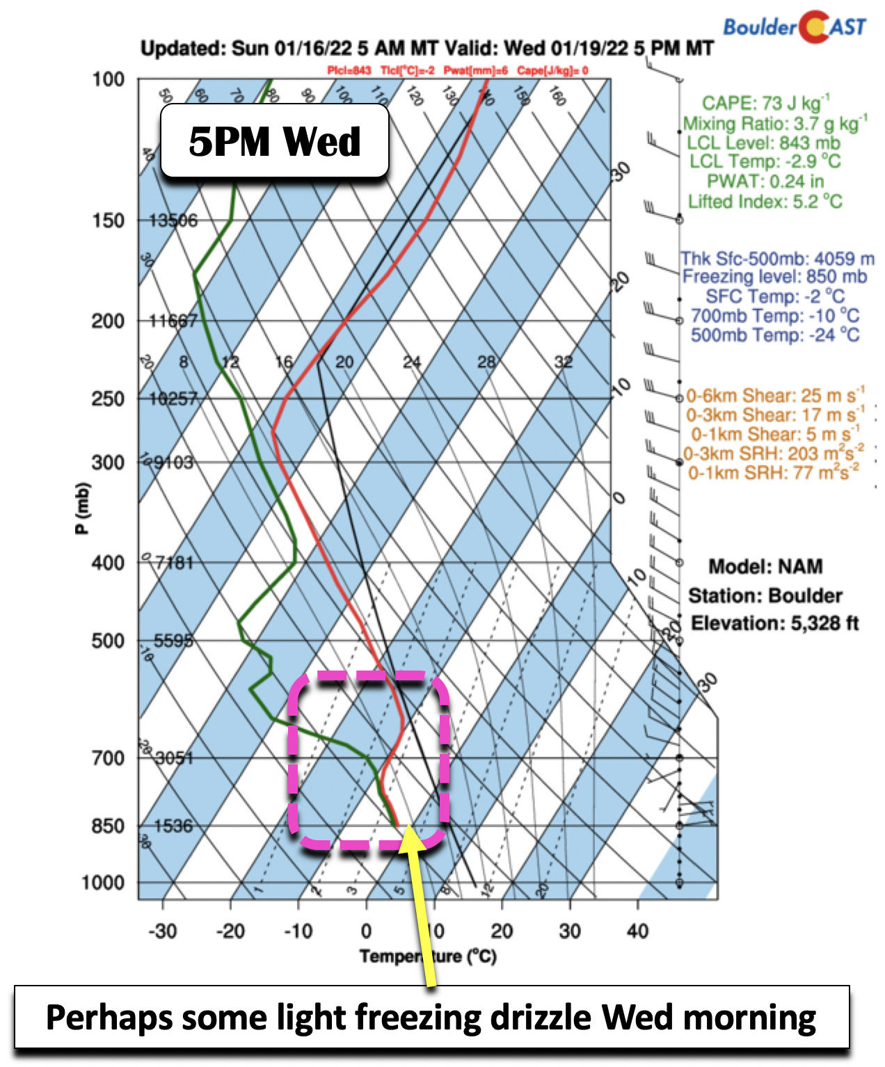
As for our precipitation chances, we think the best bet will be for light freezing drizzle or flurries. There is very little upper-level support with this mid-week system. We’re generally only seeing weak low-level upslope along the Front Range aided by a strong 1045+ mb Arctic high across Montana Wednesday.

The forecast sounding of temperature and dewpoint with height from the NAM model for Wednesday shows why we think there will be a wintry mix of freezing drizzle or flurries instead of pure snow. The sounding indicates saturation at low-levels but very little lift and moisture at mid-levels. The airmass is also below freezing at the surface but the temperature structure favors very little ice in the cloud and instead more supercooled liquid (entirely above -10°C). For this reason, some light freezing drizzle is possible Wednesday morning over the area but not much more. Overall, wintry impacts on Wednesday look minimal given the weak forcing but it certainly bears watching for a light glaze of ice or a few flurries.
The Arctic air continues to move southeast by Thursday, encompassing much of the nation (below), with well below zero temperatures in the upper Midwest.

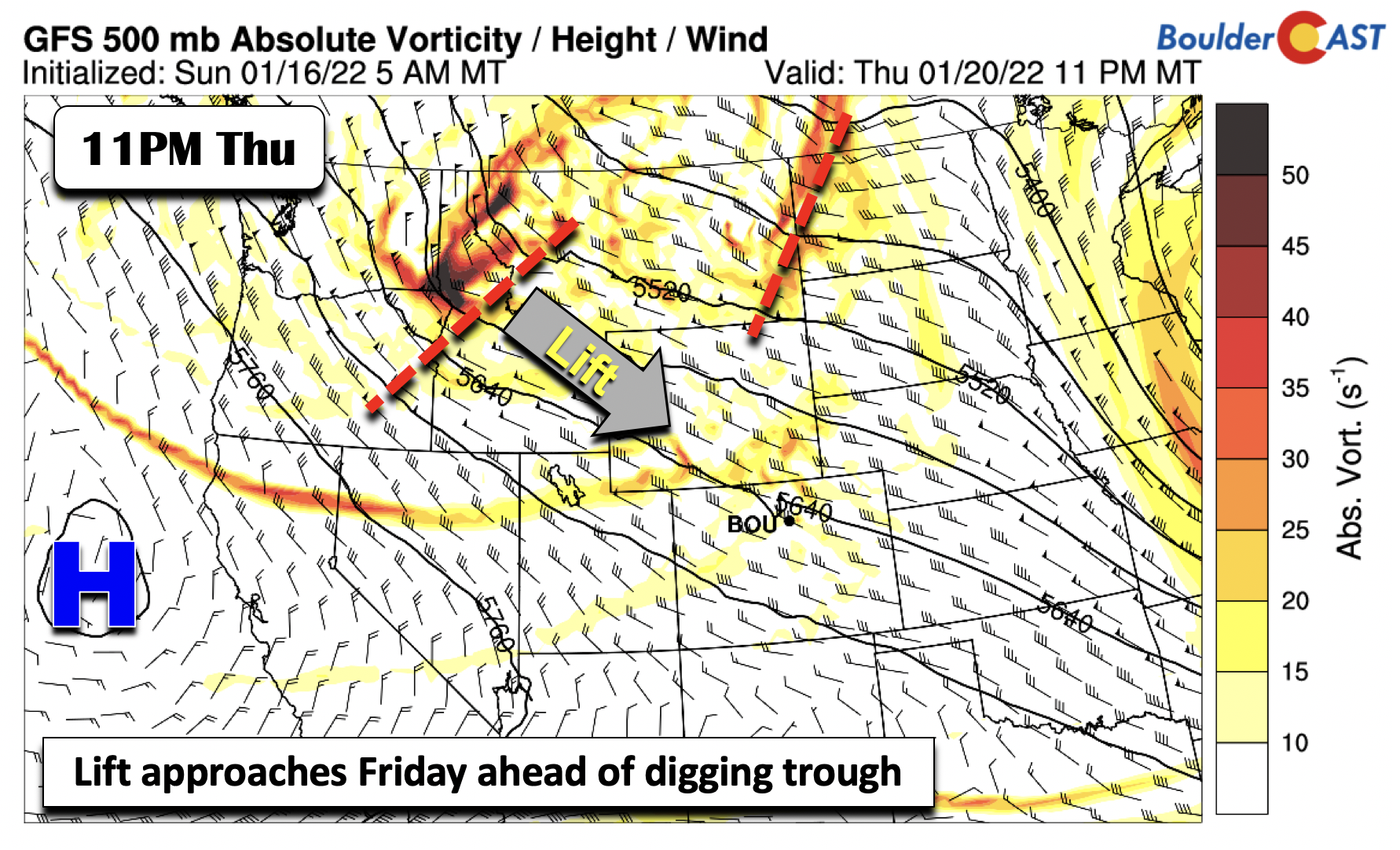
A westerly return flow will take shape midday Thursday as the trough moves eastward, allowing the coldest Arctic air to inch away from the Front Range. As a result, highs Thursday should increase to near the upper 30s to maybe 40 degrees. A sunny day will be followed by increasing clouds late in the day ahead of a secondary deepening trough and shortwave projected to come out of Montana and Idaho. This is the secondary system we had mentioned earlier as seen in the ensemble guidance for Friday.
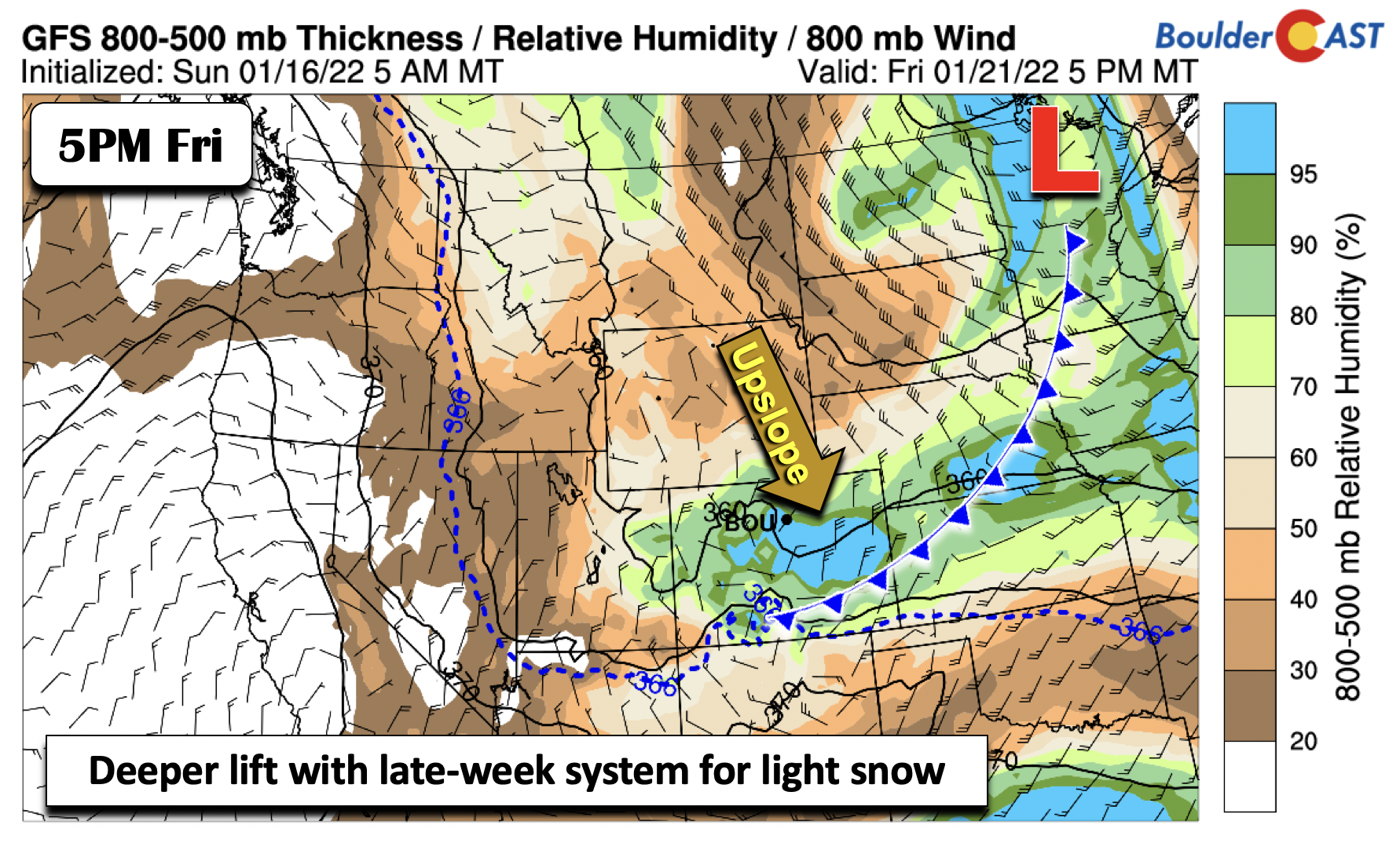
The late-week system, if it were to come to fruition as models are showing, would pack more moisture as indicated below.

In addition, upslope flow will combine with deeper lift aloft (below), favoring snow as another cold front allows that chillier air to seep back into the Front Range. Temperatures for Friday should be similar to Thursday around the upper 30s to near 40, but may be colder if the Arctic air surges closer to Colorado than expected.
As for potential snow amounts, the GFS does show the potential for light measurable snow, consistent with the Euro model and GEFS ensembles. A lot can change with this late week system so confidence is low but it certainly it looks promising for snow.

Based on the current probabilities, the most likely scenario is a 1-3″ snow event to end the week.

The first half of the weekend will stay cool but with a gradual rise to more average temperatures late in the weekend into early next week of around 50 degrees.
Stay up to date with Colorado weather and get notified of our latest forecasts and storm updates:
Forecast Specifics:
Monday: Mostly sunny and very mild with upper 50s to lower 60s on the Plains and lower 50s in the Foothills.
Tuesday: Increasing clouds and mild with low to middle 50s on the Plains and middle 40s in the Foothills.
Wednesday: A wintry mix of freezing drizzle or flurries possible in the daytime. Otherwise, cloudy and cold in the low 30s on the Plains and middle 20s in the Foothills.
Thursday: Sunny skies and chilly with highs near 40 degrees for the Plains and around 30 in the Foothills.
Friday: Mostly cloudy with a chance of light accumulating snow and highs in the upper 30s to around 40 on the Plains and lower 30s in the Foothills.
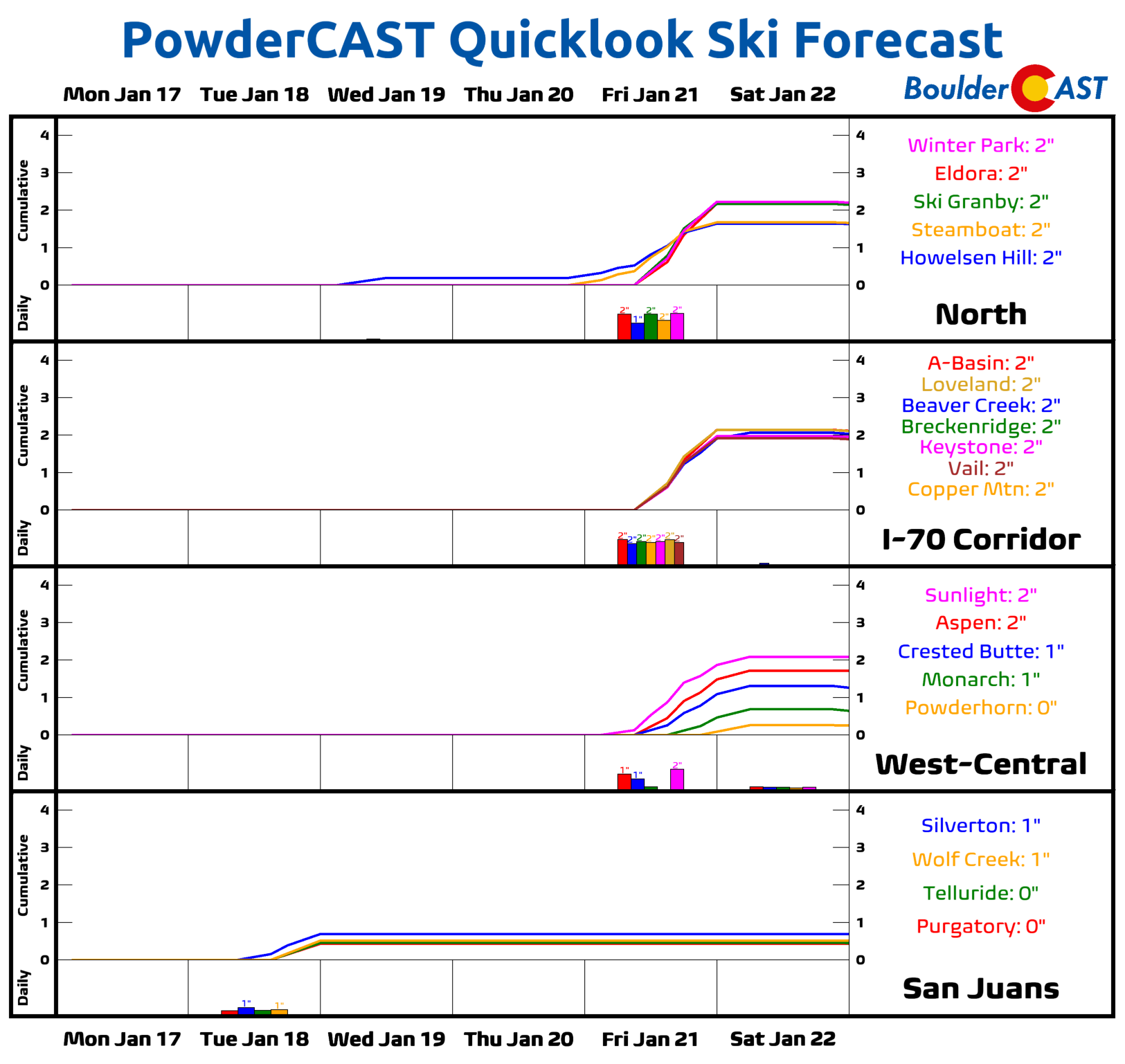
Mountains: A very quiet week will be found over the High Country through Thursday, with just a few areas of light flurries/snow prior to Friday. A better chance of snow arrives on Friday with a more potent storm system.
Help support our team of Front Range weather bloggers by joining BoulderCAST Premium. We talk Boulder and Denver weather every single day. Sign up now to get access to our daily forecast discussions each morning, complete six-day skiing and hiking forecasts powered by machine learning, first-class access to all our Colorado-centric high-resolution weather graphics, bonus storm updates and much more! Or not, we just appreciate your readership!
Spread the word, share the BoulderCAST forecast!


You must be logged in to post a comment.