Northwest flow aloft will keep the start of 2025 cool and largely dry for the lower elevations. However, ridging aloft will allow for milder temperatures by the latter part of the week. The High Country will cash in on more snow Thursday and Saturday, perfect for skiers looking to start the New Year right. We also recap the brief high wind event that occurred on Monday.
This week’s highlights include:
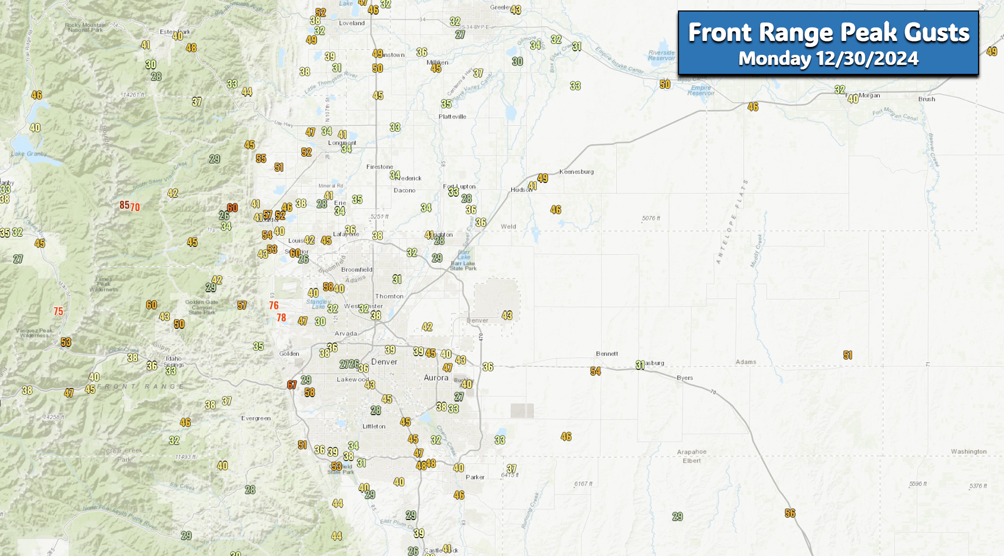
- Monday’s High Wind Event Recap: Widespread gusts of 35 to 60 MPH briefly were observed on Monday, with a few common windier location exceeding 70 MPH
- A Quiet Outlook: The weather on the Plains will be generally quiet this week under continued northwest flow
- Snow Chances: Minimal through the work week, with a possible chance of light snow during the upcoming weekend in the Metro area. The Mountains will see several waves of snow with powder conditions for the ski resorts
- Temperatures Remain Cool: Highs begin below normal in the 30s, but rise back into the 40s throughout the extended. No real “warm” days appear in the forecast
- New Year’s Eve Chill: Quiet but cold conditions are expected Tuesday evening/night, bottoming out in the upper teens by midnight to ring 2025!
DISCLAIMER: This weekly outlook forecast is created Monday morning and covers the entire upcoming week. Accuracy will decrease as the week progresses as this post is NOT updated. To receive daily updated forecasts from our team, among many other perks, subscribe to BoulderCAST Premium.
Daily Forecast Updates
Get our daily forecast discussion every morning delivered to your inbox.
All Our Model Data
Access to all our Colorado-centric high-resolution weather model graphics. Seriously — every one!
Ski & Hiking Forecasts
6-day forecasts for all the Colorado ski resorts, plus more than 120 hiking trails, including every 14er.
Smoke Forecasts
Wildfire smoke concentration predictions up to 72 hours into the future.
Exclusive Content
Weekend outlooks every Thursday, bonus storm updates, historical data and much more!
No Advertisements
Enjoy ad-free viewing on the entire site.
A gusty December 30th yesterday, but nothing like 2021
After a lot of unnecessary hype, and in some cases wildly irresponsible public messaging, yesterday’s short-lived high wind event thankfully came and went without any real problems across the Front Range. There were a few small grass fires reported, but fortunately they were quickly contained. As we detailed in our lead-up forecast, Monday’s blustery affair wasn’t going to be a typical high wind setup for our area. There were competing atmospheric factors at play, some which would favor high winds:
- strong cross barrier flow aloft
- subsidence behind a trough axis
- daytime mixing and sunny skies
- a strong east-west pressure gradient)
…and others which would suppress them:
- little to no mountain wave enhancement
- snowfall in the mountains
- lift from the left exit region of the jet)
Our conclusion was the following:
When it was all said and done, peak wind gusts Monday morning generally ranged from 35 to 60 MPH across the region, with a few of the typical exceptionally windy locations between Boulder and Golden reporting gusts over 70 MPH. Yes it was windy Monday, but it wasn’t even in the same realm as conditions that rapidly spread the Marshall Fire back in 2021. That day had gusts up to 110 MPH fanning the flames for many hours — and as you will see in a moment, winds that fateful day lasted much longer than what transpired yesterday.
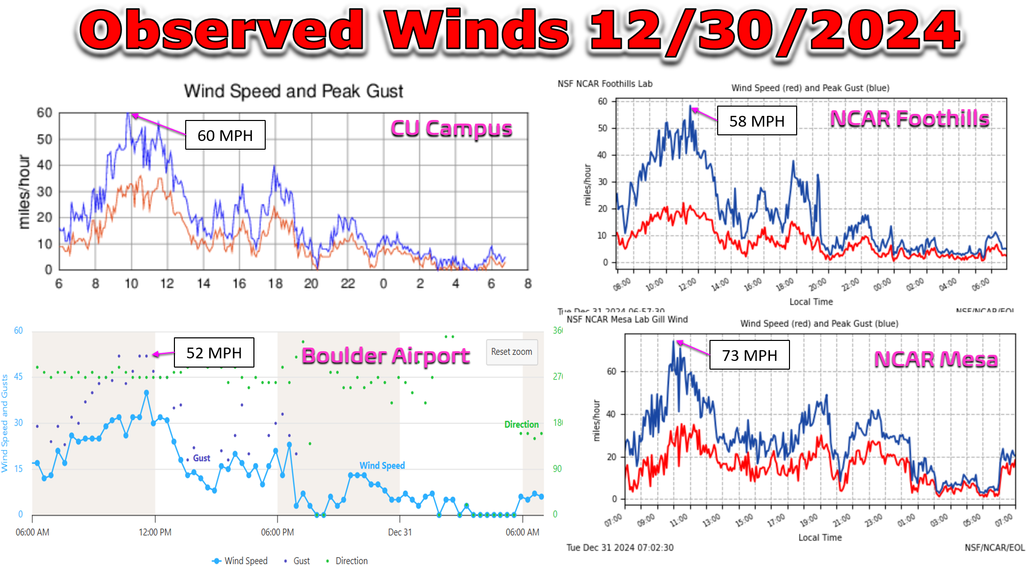
Looking at a few reliable observation sites in the Boulder area shows that the maximum gusts on Monday ranged from 52 to 73 MPH across the city. Winds were only gusting above 40 MPH for about 3 to 4 hours.
As usual, the windiest spot in Boulder was on the the southwest side of town at the base of the Flatirons, with the NCAR Mesa Lab reporting the only observed gust in the city over 70 MPH. While that may seem intense, and it is, that’s not extreme nor atypical for this location. NCAR Mesa is the windiest place in Boulder, which itself is the windiest actual city in the Denver Metro area — the crème de la crème, if you will. Did you know that NCAR Mesa had a half dozen gusts over 80 MPH and even one gust of 95 MPH just TWO weeks ago? There was no hype for that specific (mountain wave) wind event, and it was wildly more intense in parts of Boulder than what we saw yesterday!
💨 At least one wind gust Sunday evening exceeded 90 MPH in South #Boulder! Who felt that one? #COWX pic.twitter.com/yxqfEHo4hp
— BoulderCAST Weather 🏔️❄️ (@BoulderCAST) December 16, 2024
Let’s face the facts folks — the Front Range is a windy place eight months out of the year (October to May), with Boulder County often leading the way with the strongest and most frequent occurrences of high winds. The widespread nature of moderately strong gusts on Monday was about the only somewhat uncommon aspect from event. Were Monday’s winds worth all the hype, fear-mongering and riling up of a community still deeply scarred by half their town burning to the ground just three short years ago? No. No, it wasn’t. Fire danger was certainty elevated on Monday, but let’s keep the doomsday comparisons to a minimum when our next windstorm arrives — something that will likely be sooner rather than later under the current pattern ahead. With intense drought still rampant across the area, we need to do better next time.
The week ahead: A quiet exit to 2024 and entry into 2025
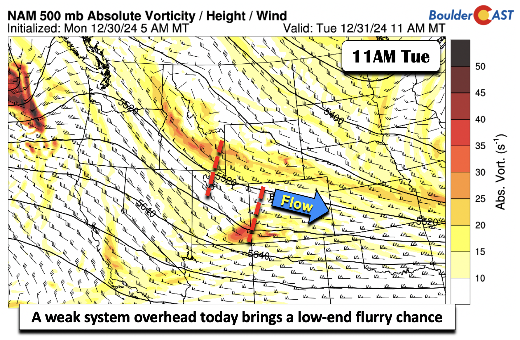
The impending transition to 2025 will be a quiet one. After yesterday’s gusty winds and fire concerns, the weather turns colder but quiet as we head into the New Year. A general northwest flow aloft will more or less persist through Thursday. Getting into specifics for Tuesday, a shortwave in the northwest flow will track overhead this afternoon and evening. There are actually two shortwaves set to move through, but the two will largely pass through with just some clouds for the Boulder-Denver area. We would not be surprised if a few spots see a snow flurry or two Monday evening, but that would be about it. The High Country could pick up a light dusting.
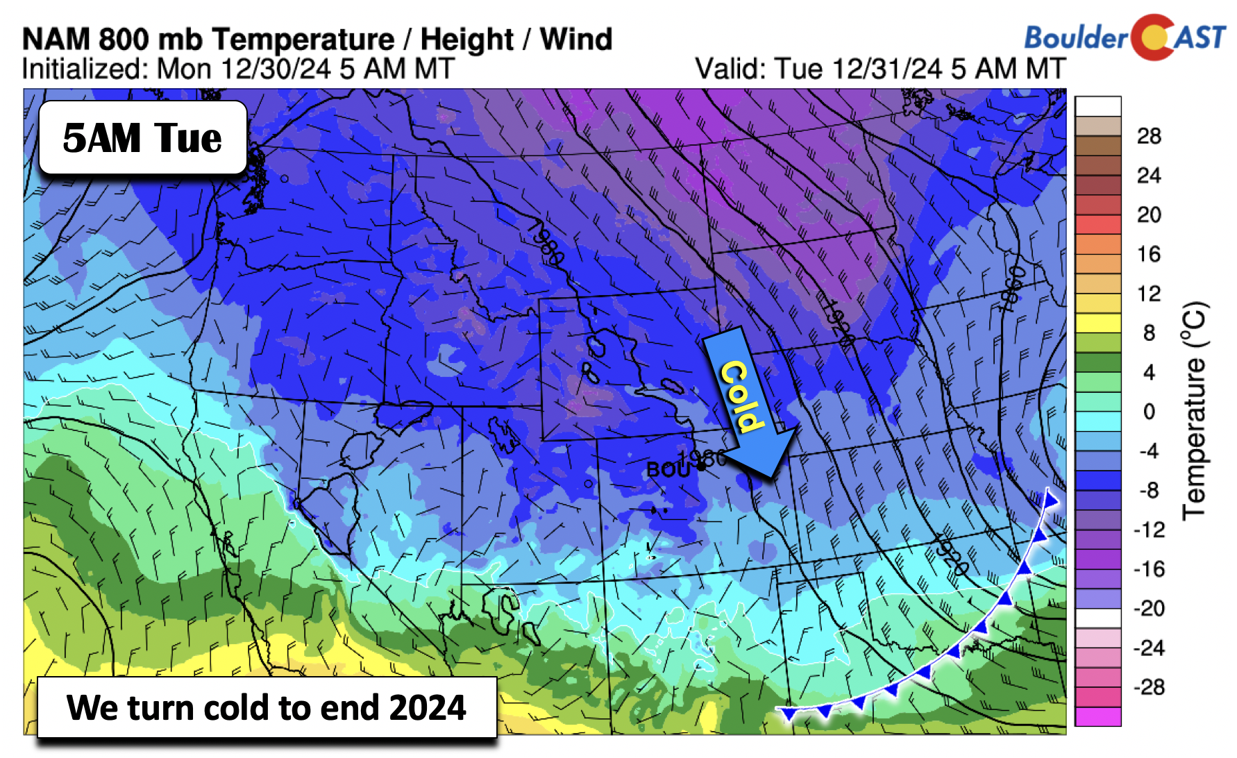
The same system which made us windy on Monday is now over the Mid-Mississippi Valley. It brought a cold front through last night and is turning us colder and below normal for the last day of 2024 — expect highs in the mid 30s with light winds. Fun fact: The final day of December will be only the second one with below normal temperatures during the entire month — it’s been that persistently warm of late!
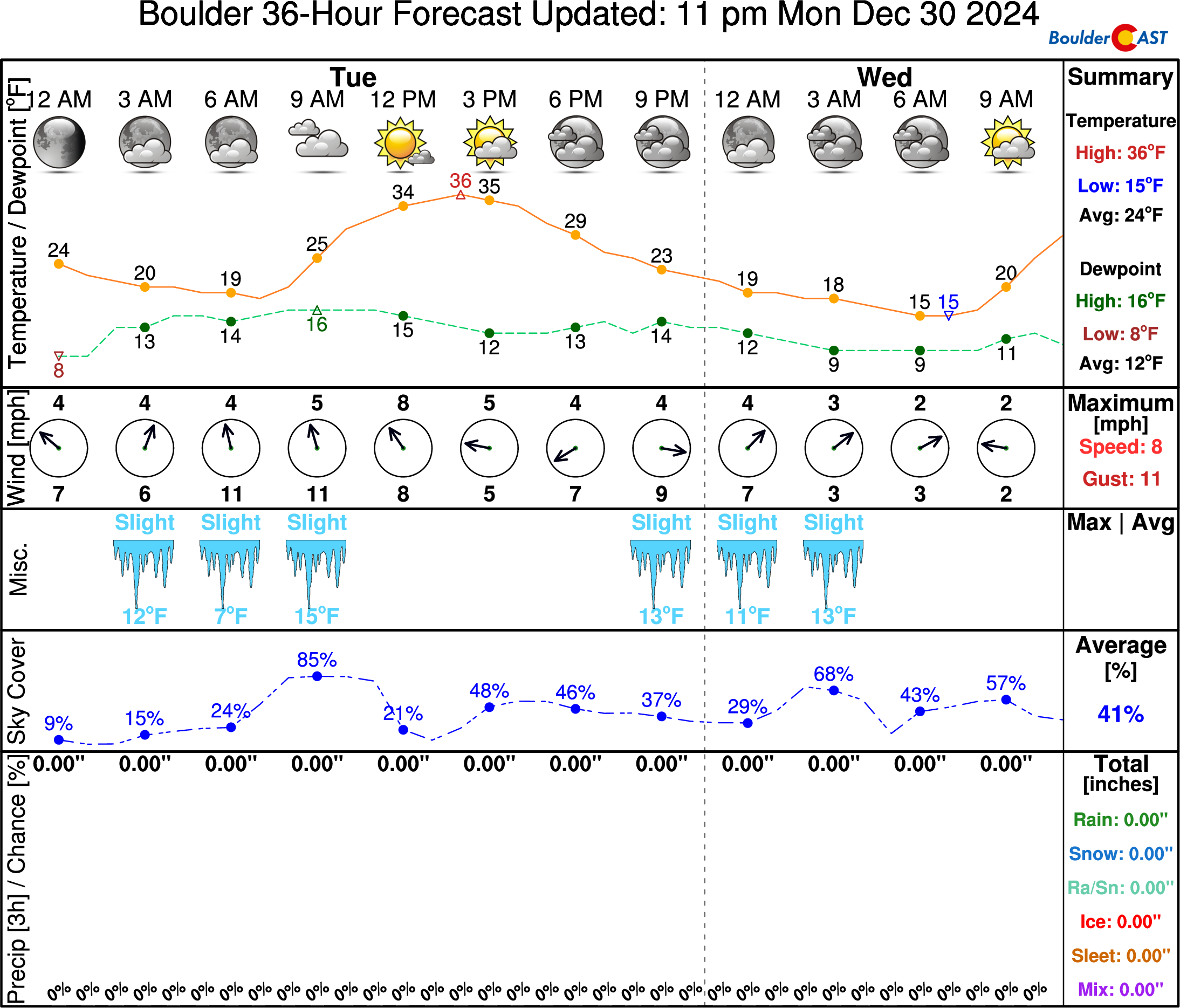
For those heading out and about for New Year’s Eve festivities, plan on a quiet but cold evening. By the time the clock strikes midnight tonight, temperatures will be in the upper teens under partly cloudy skies:
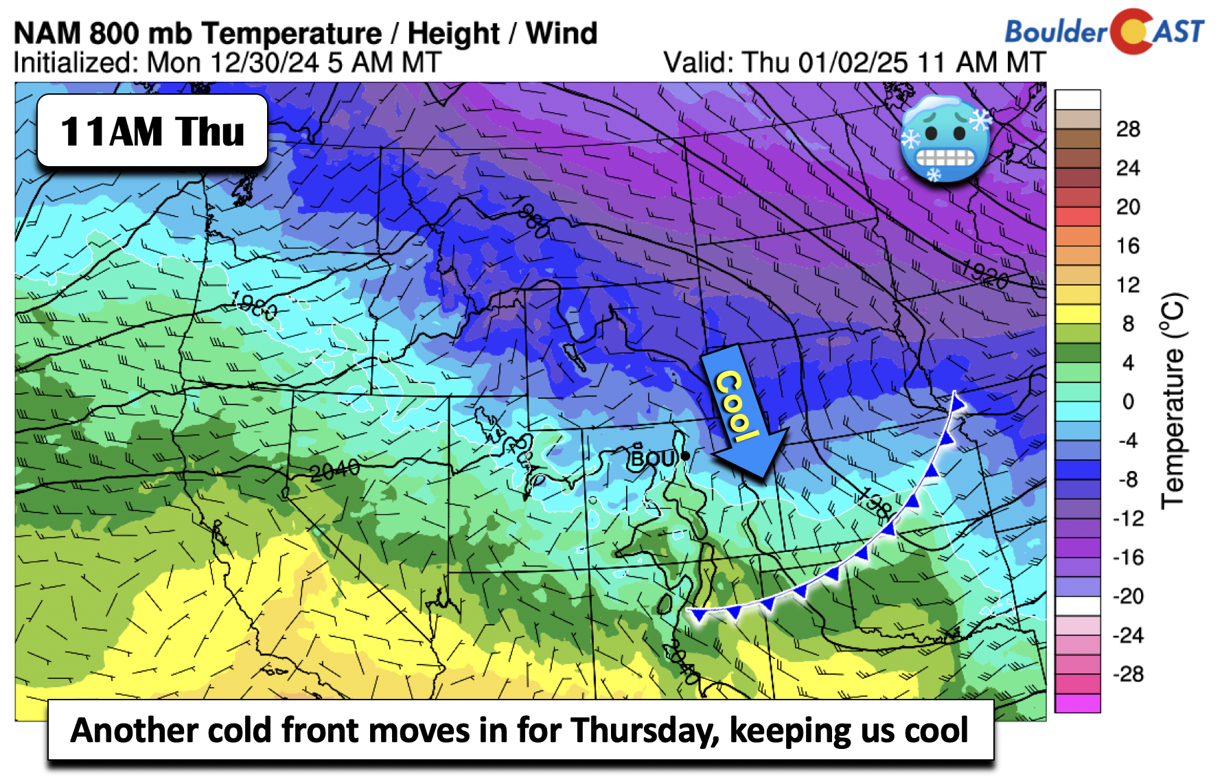
While we should see a general moderation in temperatures in the early days of 2025, the northwest flow aloft will bring several more systems through, keeping the cold air not too far away. A gradual warm-up on Wednesday under light westerly downslope flow should favor readings near 40° on the Plains. Another cold front drops through Thursday. This one brings a glancing blow, with the cold air in some models suggesting it lifts out by midday, while other guidance suggests it lingers. Nevertheless, upper 30s to middle 40s are most favored, slightly below average for early January.
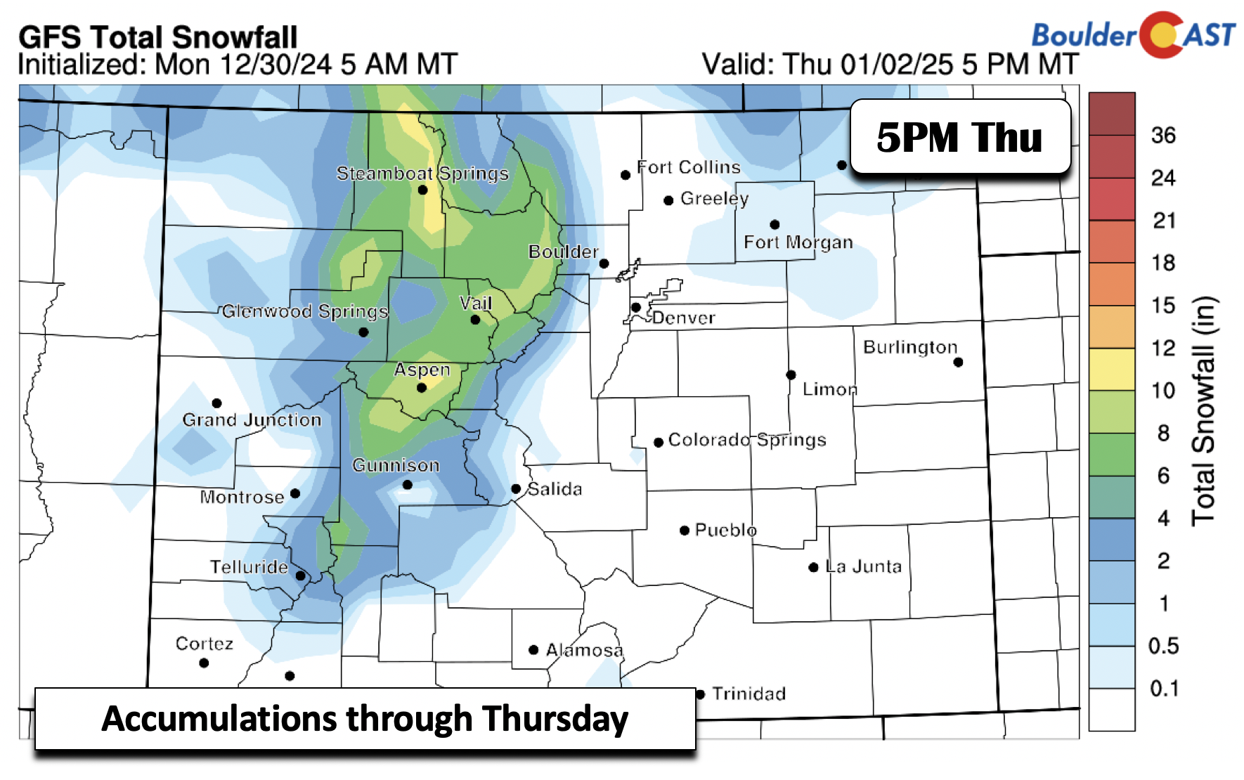
The system on Thursday has an upper-level counterpart (not surprising!). The northwest flow will favor orographic snow along and west of the Continental Divide, from Steamboat to Aspen. Several inches of snow are possible over the ski resorts from late Wednesday night into midday Thursday — likely around 4 to 10 inches for many ranges and resorts. New Year skiers will be happy! The same upper-level system could bring a stray snow flurry or snow shower on the Plains Wednesday night, but that chance sadly appears minimal.
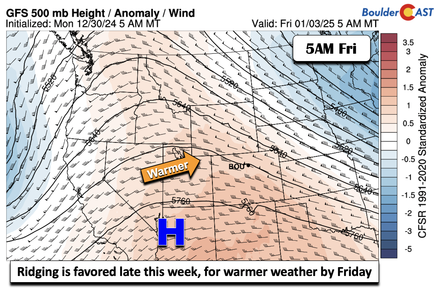
All guidance is in fairly good agreement that by Friday upper-level ridging will build east from the West Coast and into Colorado. This should allow for our warmest day of the week and of early 2025 with temperatures creeping above normal well into the 40s. The cooler air is not too far away, over Wyoming and Nebraska, and that is slated to move back south come Saturday or Sunday.
Odds of snow increase this weekend
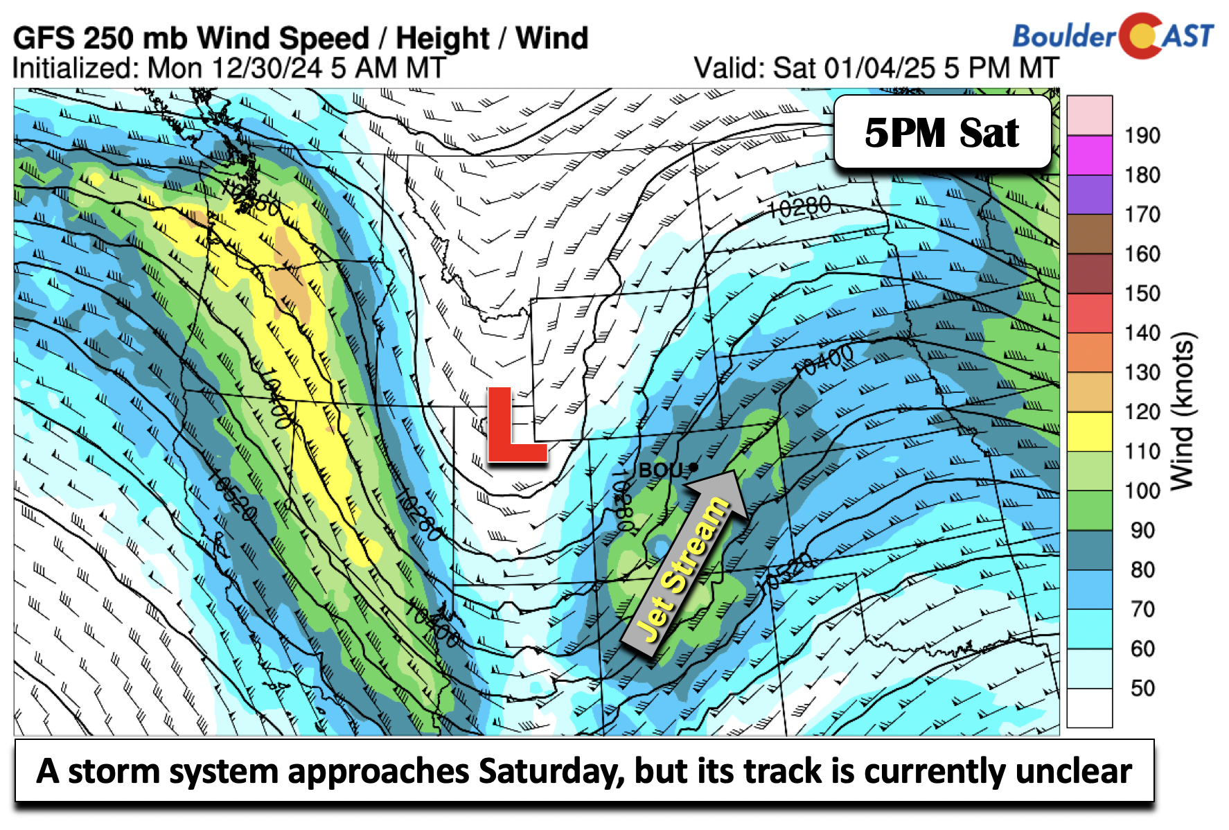
Snow chances, albeit with uncertainty, increase for our region Saturday into Sunday. Guidance is mixed on the passage of a stronger mid-level trough, but nearly all ensemble models show a system moving onshore from the West Coast and tracking across the state. Where it ultimately lands is unclear at this point, but it’s perhaps our best snow chance of the week.
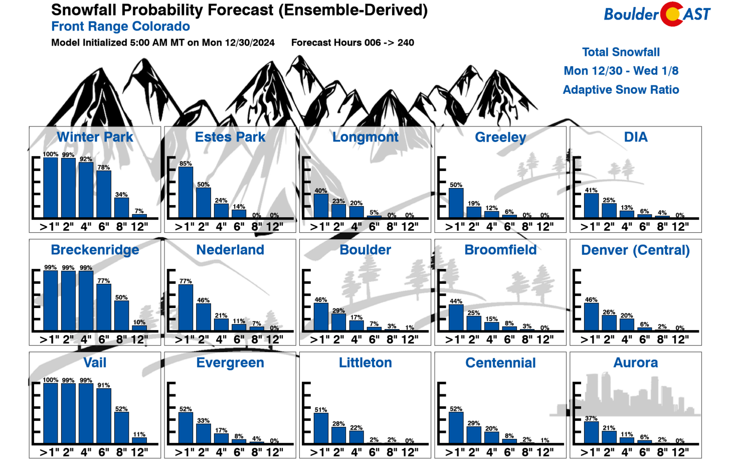
The High Country is certainly slated to see the best snow odds with the Thursday and Saturday systems, but snow chances do increase on the Plains to around 40-50% for an inch or more by this weekend. We will continue to track this as we get closer. It is too unclear to make any predictions at this point — other than it doesn’t look like a storm capable of producing more than light snow (if any) for the Metro area.
Colder weather should ensue Saturday ahead of the system, though some guidance suggests this may wait until Sunday. For now, expect a gradual colder trend into Saturday and especially Sunday, back to below normal.
Finally, if you want to help support the passionate work we do here at BoulderCAST and/or wish to receive a morning weather update from us every single day for the next year, consider subscribing to BoulderCAST Premium; our 2024 holiday sale is ongoing through January 2nd. Or not, we just appreciate your readership!
Have a safe, healthy and wonderful transition to 2025, Happy New Year!
Forecast Specifics:
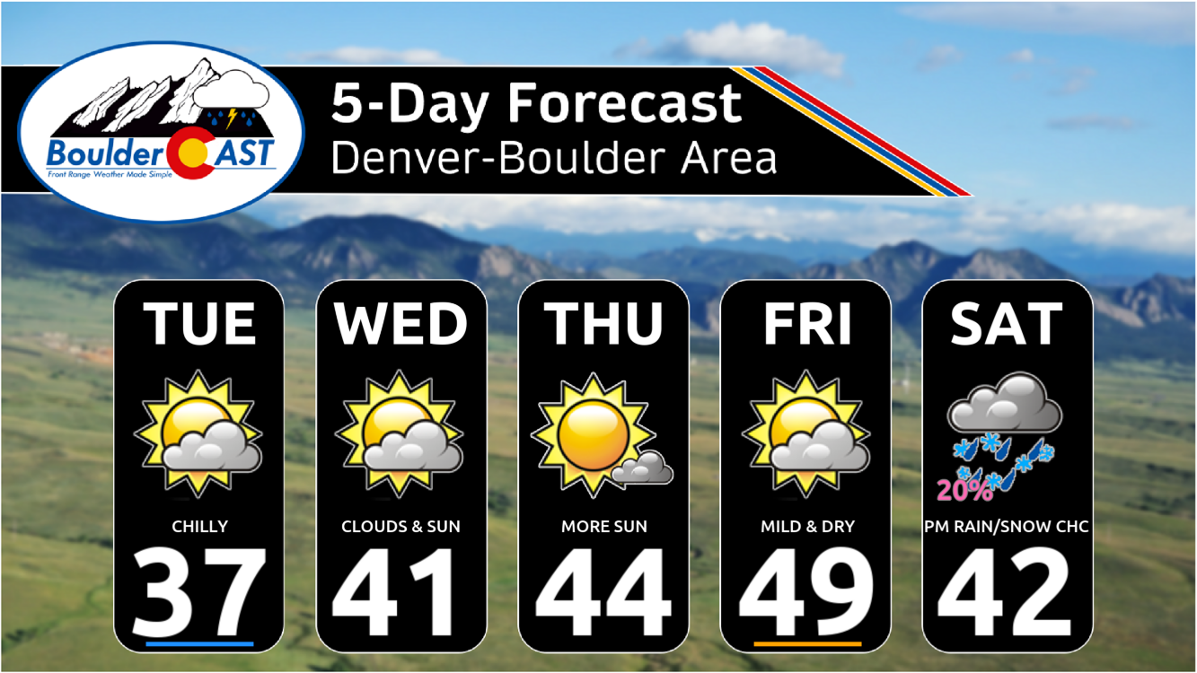
Tuesday: A mix of clouds and sun and colder. High temperatures in the middle 30s on the Plains and middle 20s in the Foothills. There could be a flurry or two in the evening, mainly north/east of Denver and in the highest Foothills.
Wednesday: A mix of clouds and sun. High temperature still cool near 40 on the Plains and middle 30s in the Foothills. Light snow will spill-over into the high Foothills overnight with minor accumulations possible above 7500 feet (1-2″ tops). The lower elevations may see a few flurries as well during the overnight.
Thursday: Partly to mostly sunny. High temperatures in the lower to middle 40s on the Plains and middle 30s in the Foothills.
Friday: More sunshine and warmer with highs in the upper 40s on the Plains and upper 30s in the Foothills.
Saturday: Increasing clouds with a slight chance of rain/snow showers. Temperatures top out in the 40s on the Plains with 30s in the Foothills.
Get BoulderCAST updates delivered to your inbox:
DISCLAIMER: This weekly outlook forecast is created Monday morning and covers the entire upcoming week. Accuracy will decrease as the week progresses as this post is NOT updated. To receive daily updated forecasts from our team, among many other perks, subscribe to BoulderCAST Premium.
Daily Forecast Updates
Get our daily forecast discussion every morning delivered to your inbox.
All Our Model Data
Access to all our Colorado-centric high-resolution weather model graphics. Seriously — every one!
Ski & Hiking Forecasts
6-day forecasts for all the Colorado ski resorts, plus more than 120 hiking trails, including every 14er.
Smoke Forecasts
Wildfire smoke concentration predictions up to 72 hours into the future.
Exclusive Content
Weekend outlooks every Thursday, bonus storm updates, historical data and much more!
No Advertisements
Enjoy ad-free viewing on the entire site.
Enjoy our content? Give it a share!




You must be logged in to post a comment.