

Well, Denver’s snowless streak finally came to an end as a dusting of frozen precipitation was reported at Denver International Airport this past Friday morning. Unfortunately, the week ahead will not continue the trend with a largely dry week expected. We are closely watching a quick-moving storm set to race across the area on Wednesday which could bring white-out conditions to the Mountains and very strong winds to the Denver Metro area. The meager chance of rain/snow with this mid-week system will offer little reprieve for the extreme drought which now encompasses the entire area.
This week’s highlights include:
- Denver’s snowless streak finally came to an end late last week
- Mild & dry to start the week under broad southwest flow
- A vigorous storm will race across Colorado on Wednesday with the main threat being strong bora winds for the Denver area and brief heavy snow in the Mountains
- A dry cold front will bring colder weather to end the week, but likely no precipitation
- Extreme drought now encompasses the entire area
DISCLAIMER: This weekly outlook forecast is created Monday morning and covers the entire upcoming week. Accuracy will decrease as the week progresses as this post is NOT updated. To receive daily updated forecasts from our team, among many other perks, subscribe to BoulderCAST Premium.

Finally, it snowed in Denver.
Last week’s sharp trough finally brought an end to the snowless streak in Denver — 232 days later — tying to the all-time record for the longest period without snow and obliterating the existing record for the latest first accumulating snowfall of the season by a solid three weeks. Weather observers at Denver International Airport officially recorded a dusting of snow on Friday.
Welcome to the 2021-22 snow club, Denver! #COwx https://t.co/dr3KjFX3l6
— BoulderCAST Weather (@BoulderCAST) December 10, 2021
Last week’s snow was also a significant one for Boulder. The 1.0″ of snow that fell in the city Friday morning was the biggest snowfall event of the season so far. Yup, it’s been that kind of autumn.
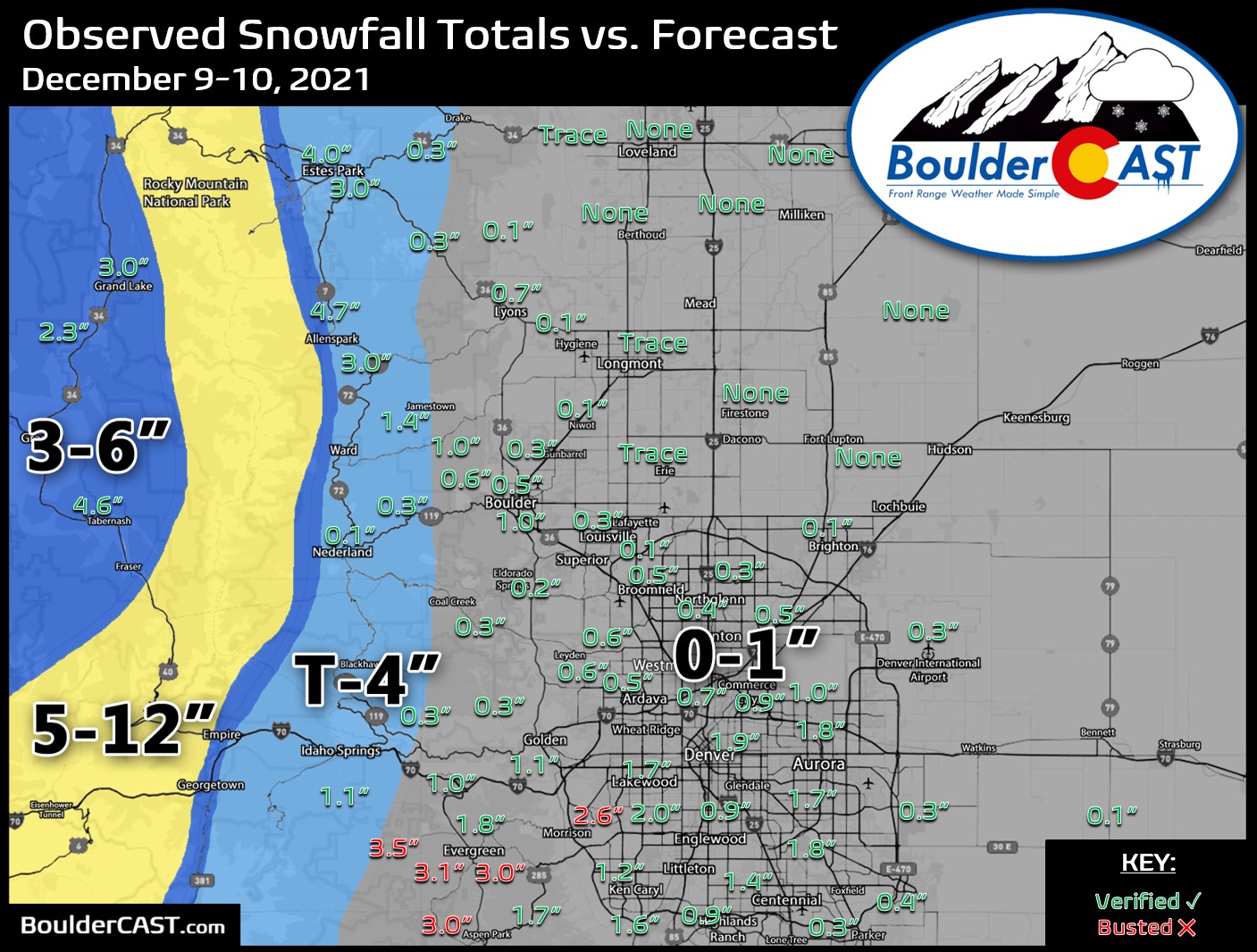
This snow came early Friday morning as a few localized bands of moderate snowfall developed across the Front Range. The hardest hit areas saw up to 2″ from this quick-hitting jet-forced snow band. That was mainly in central and southern Denver. Boulder actually missed out almost entirely on the primary band itself, but fortunately a few much smaller ones developed right overhead to produce the whopping one inch of snowfall for the city. The big band and also the tiny one over Boulder are both shown in the radar animation below from early Friday morning (December 10th).

The week ahead: Mild to begin
We’ll start the week with rather quiet weather across the state of Colorado. The large-scale pattern over the United States has a ridge in the center of the country with a deep fetch of moderate southwesterly flow streaming into Colorado. This setup will help bring mid and upper-level moisture to the region through Tuesday, but no precipitation just yet.
A look at the GOES-East infrared satellite animation from overnight shows the broad flow arriving from our southwest. We’re already seeing some lee cloudiness over east Colorado early Monday morning associated with some of the lofted moisture. Further west, California is getting hammered with a major atmospheric river event with 5+ feet of snow expected for the central and northern Sierras.
GOES-East infrared satellite animation from early Monday morning
Some of that moisture will reach Colorado, but mainly only in the San Juans Tuesday into Wednesday with lighter snowfall elsewhere.

GFS model-derived snowfall forecast through Wednesday afternoon
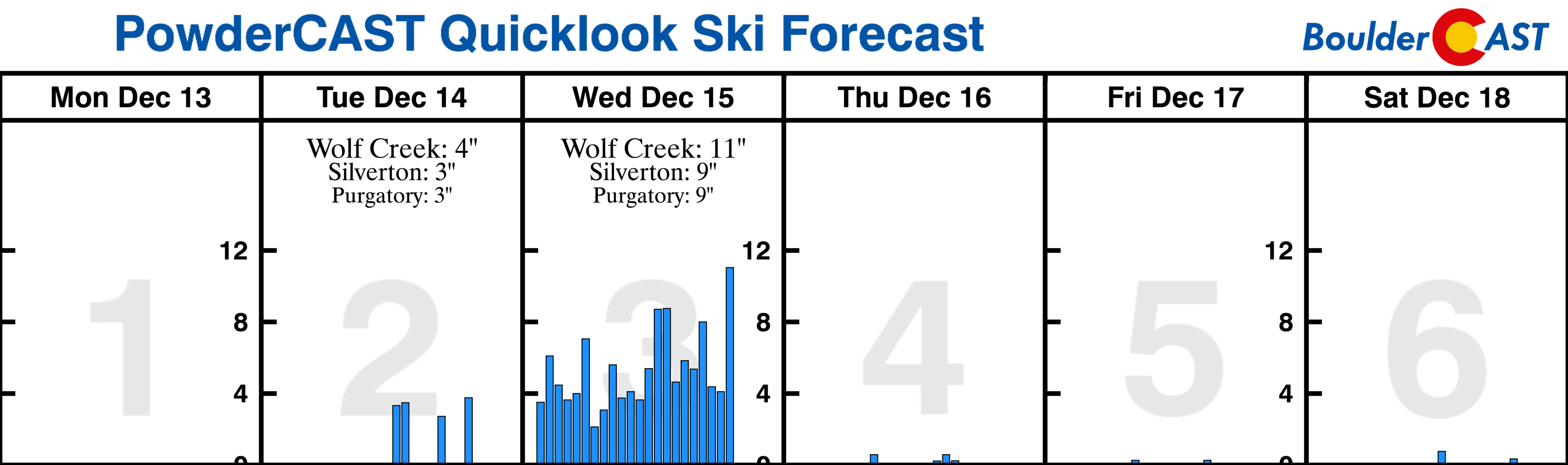
Winter Storm Watches are posted for the favored San Juans for 6-14″ of snow under this southwest flow pattern.

Wolf Creek Ski Area picked up more than 30″ of fresh snow last week and another foot or more could fall this week there.

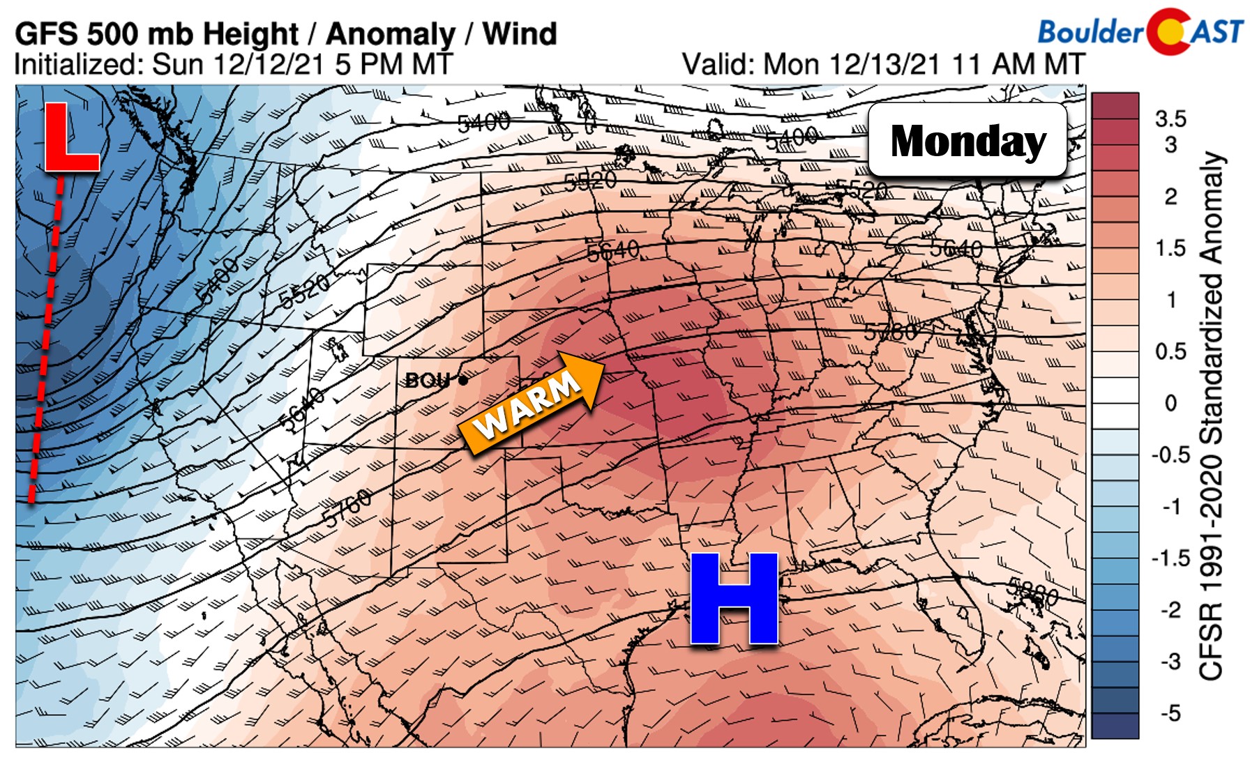
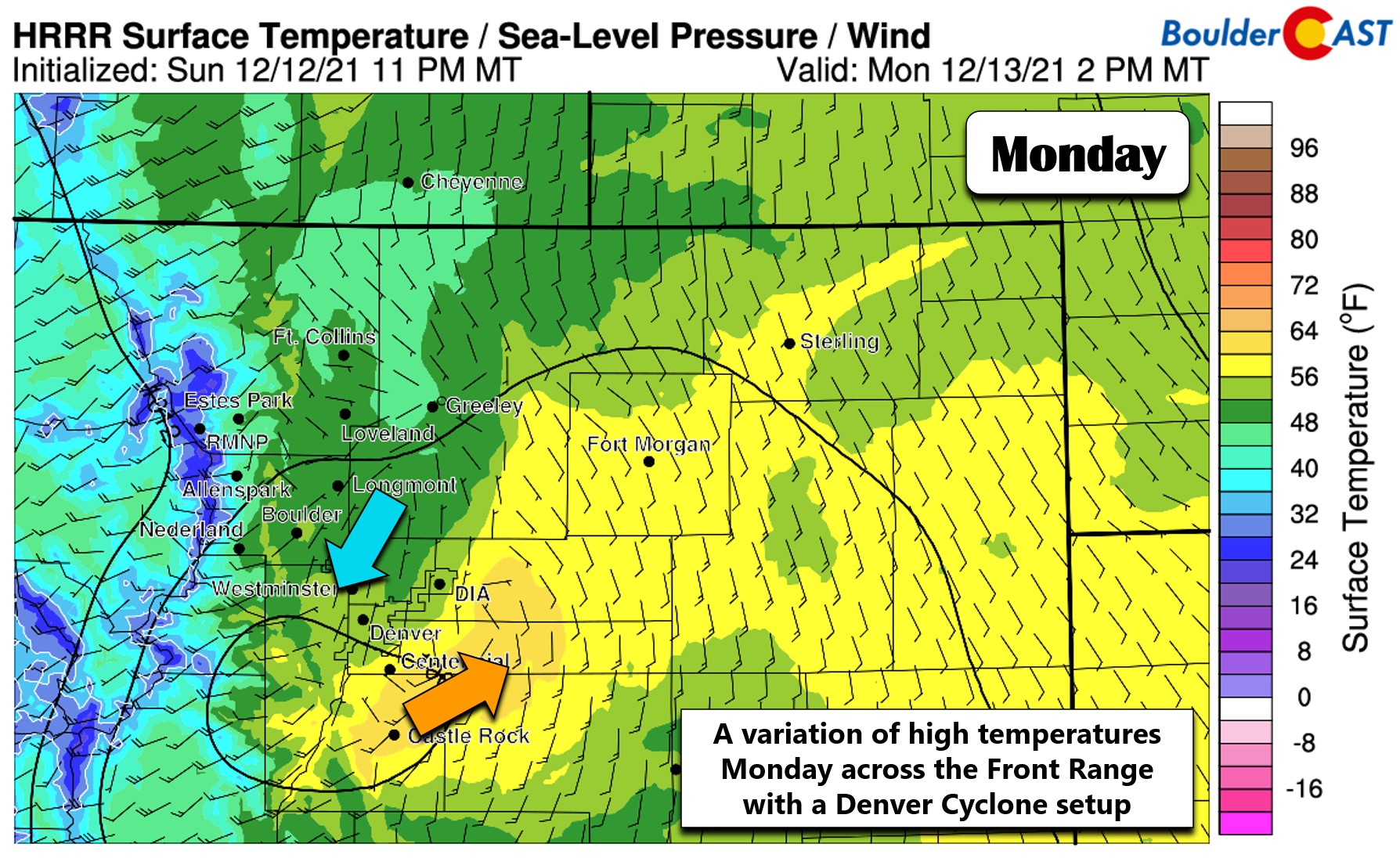
For most of northern Colorado, things will be quiet Monday and Tuesday with temperatures landing above normal. On Monday, models show a Denver Cyclone setup across the area which will favor warm temperatures in south and east Denver (near 60 degrees), but slightly cooler conditions in the Boulder area (low to middle 50’s).
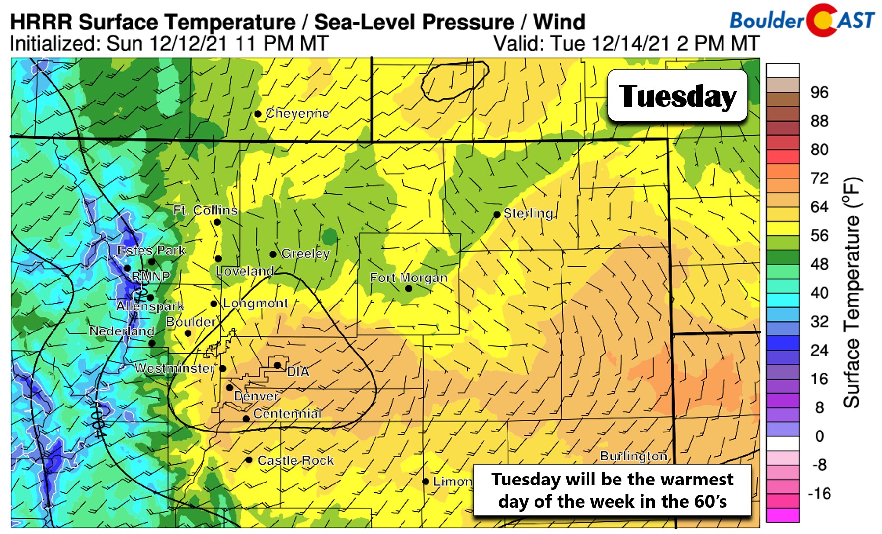
However, a more pronounced downslope pattern should facilitate a warmer day on Tuesday with most locations reaching into the low to middle 60’s in what will be our warmest day of the week! Both days will have a mix of clouds and sun.
Wild winds likely on Wednesday
As we alluded to earlier, the remnants of the atmospheric river event causing intense rain and snow to California will shift eastward and race across the Rockies on Wednesday. While strong, this storm will take a somewhat northern track and will move at an absolutely blistering pace through Denver so the impacts will be limited. Notice the strong trough and energy blowing up across eastern Colorado in the GFS 500mb vorticity forecast animation below.
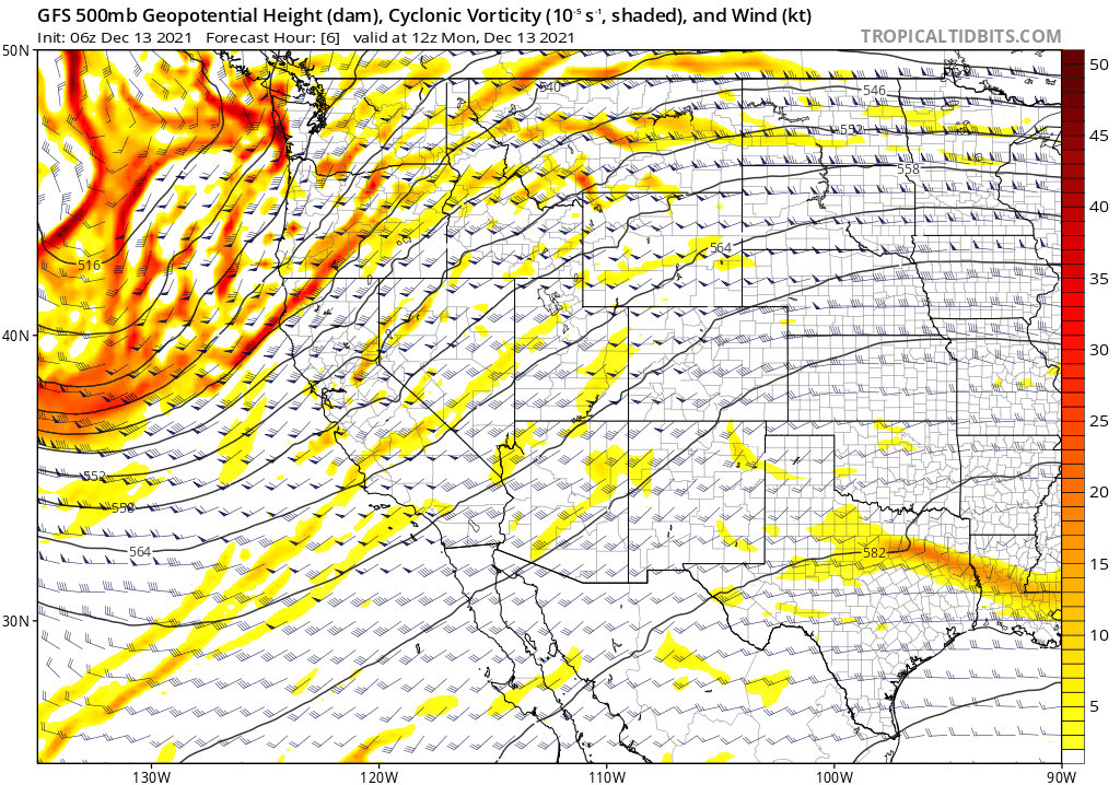
GFS 500mb vorticity and height forecast animation for Monday into Wednesday
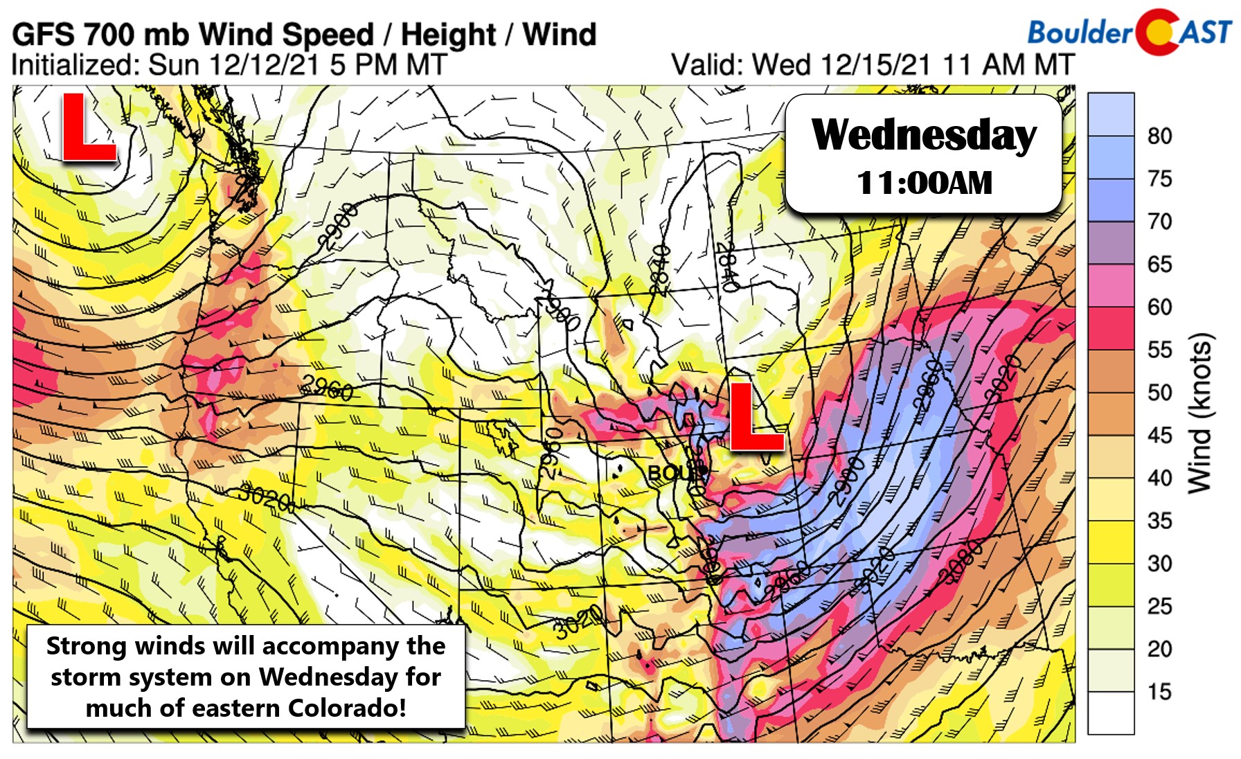
This vigorous storm will bring a slew of changes for our Wednesday, including brief whiteout conditions to the Mountains, a threat of rain/snow showers in Boulder, a period of strong bora winds, and of course colder temperatures. All the weather model guidance brings this storm through so rapidly and far northward that it won’t offer much chance of precipitation in our area. The GFS develops a potent 982 millibar surface low in the northeast corner of the state Wednesday morning (see below). This setup will favor snow in the Mountains, but only for a brief period of 12 hours at best.

The initial mid-level cold front that blows through will increase lapse rates enough that we could see some convective snow showers Wednesday morning into the early afternoon, especially in the Mountains. These showers will move eastward across the Denver area as well but may weaken considerably and would be a mix of rain and snow for the lower elevations. Some thunder is also possible with this wave of precipitation, but the morning timing is not favorable for that. no real accumulation is expected on the Plains, but a few inches is possible in the Mountains. For now, we’re only including a 10% chance of precipitation on Wednesday, but we’ll need to see how this setup evolves in the model runs to come.
The biggest concern for Wednesday will definitely be the WIND. A strong pressure gradient will accompany the intensifying low to our east. While the worst winds are forecast to remain across east-central and southeast Colorado where hurricane force gusts will be common, the Boulder-Denver area should see at least a brief period of very strong winds Wednesday morning into the afternoon as the system races through. Our best guess at this early stage would be widespread 30 to 60 MPH gusts for the entire area as a bora-type cold front sweeps through. A combination of the strong winds and brief snow in the Mountains could create difficult travel during the morning and afternoon hours Wednesday, so keep that in mind.
Temperatures will be much colder on Wednesday as well. Expect a mild morning ahead of the storm with temperatures in the 40’s to possibly near 50 degrees. That will be the warmest time of the day though as cooler air filters in through the afternoon with temperatures remaining steady in the 40’s or dropping down into the 30’s.
Active late week, but no precipitation
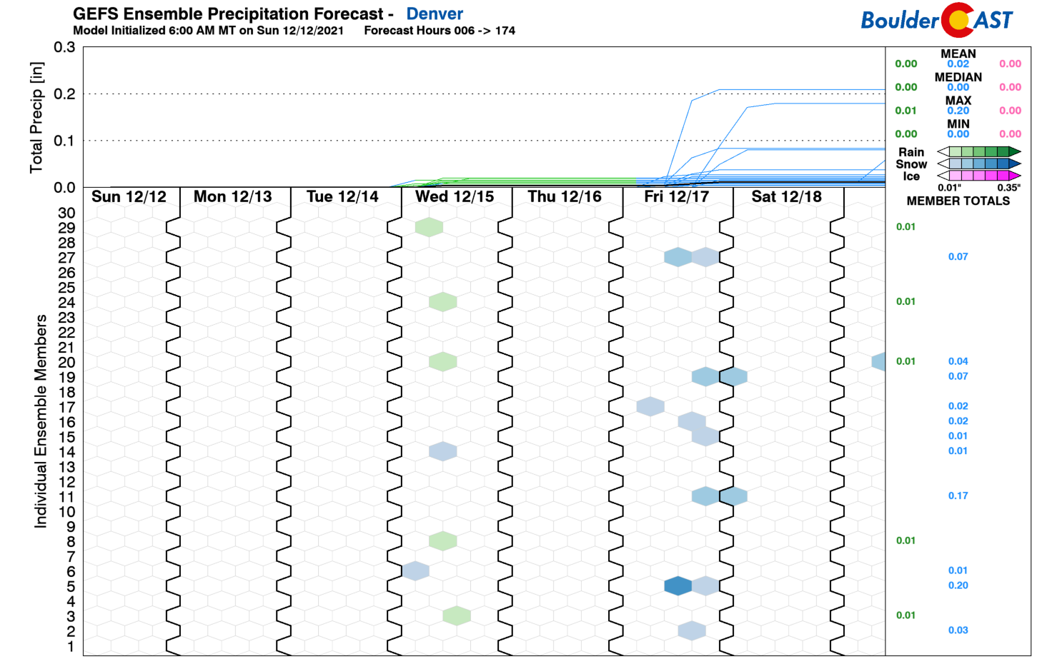
The pattern is expected to remain fairly active for the western United States to end the week as a series of minor troughs move into the Pacific Northwest and slide through the northern Rockies. None of them stand out right now as weather-makers for us, but this could change in the coming days. This setup will keep seasonal to below normal temperatures around heading through the late-week period and into the upcoming weekend. Expect highs around 50 degrees on Thursday and near 40 degrees on Friday following a dry cold front. There are a few ensemble members hinting at the potential for light snow on Friday (see below), but that seems unlikely at this juncture.
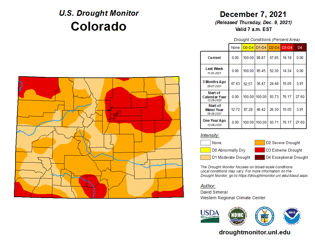
Things remain bleak as extreme drought now encompasses much of northeast Colorado, including the entire Denver Metro area. As we have discussed with you, this week will unfortunately offer no reprieve…
Latest Community Pool Results:
Stay up to date with Colorado weather and get notified of our latest forecasts and storm updates:
We respect your privacy. You can unsubscribe at any time.
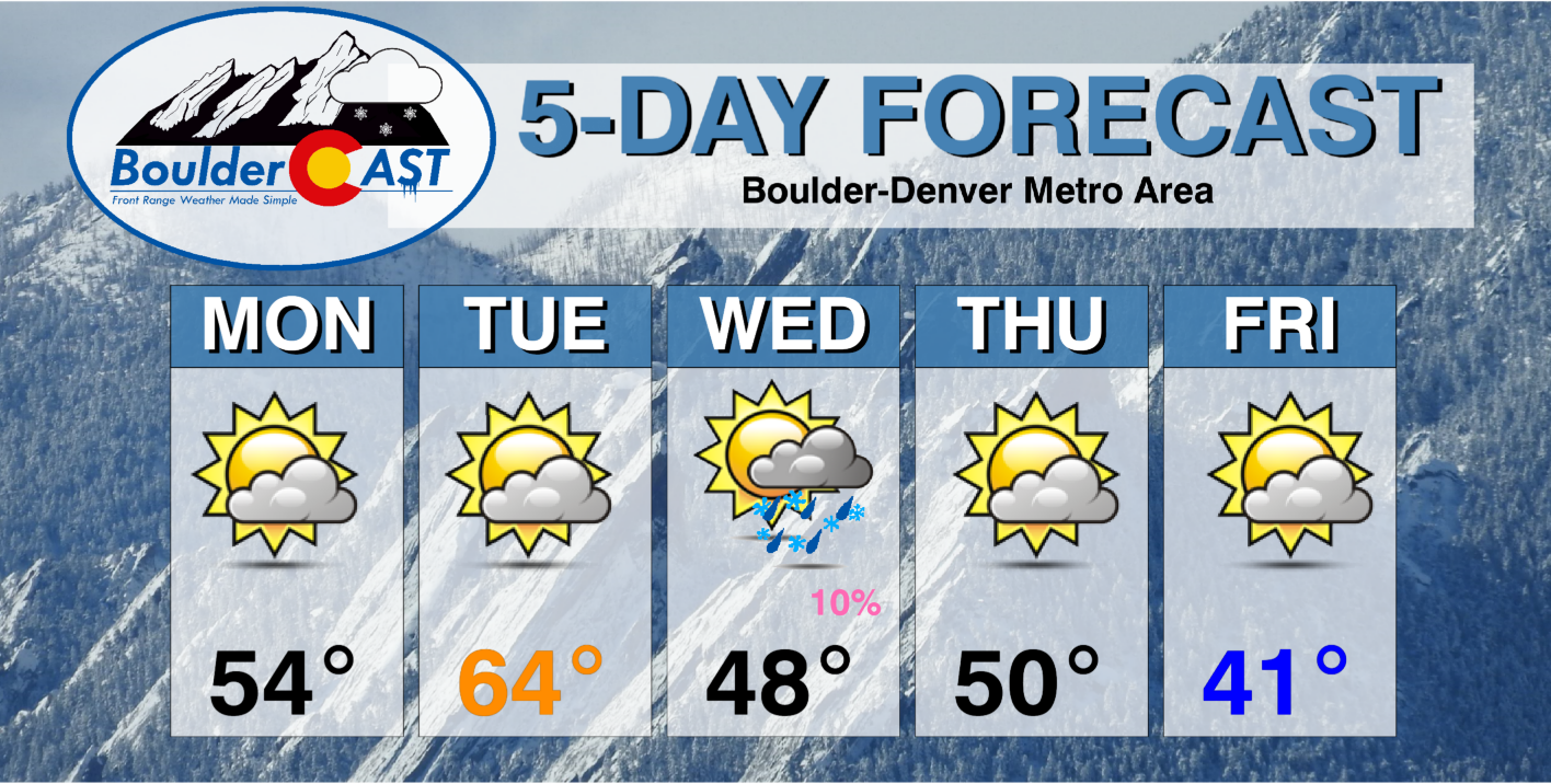
Forecast Specifics:
Monday: Thick morning wave clouds, then partly to mostly cloudy the rest of the day. Highs will be variable – near 60 south of Denver but in the lower 50’s around Boulder, with 40’s in the Foothills.
Tuesday: Partly cloudy, warm and dry with highs in the low to middle 60’s on the Plains with near 50 in the Foothills.
Wednesday: An active weather day overall with a slight chance of rain/snow showers in the morning to midday period alongside a period of strong winds with gusts up to 50 MPH. After the precip chance, skies turn partly cloudy with breezy conditions lingering. Highs in the 40’s and falling, with 30’s in the Foothills.
Thursday: Partly cloudy and seasonal with temperatures reaching near 50 degrees on the Plains and in the upper 30’s in the Foothills.
Friday: Cooler but dry with partly cloudy skies. Highs in the lower 40’s across the Plains with lower 30’s in the Foothills.
Mountains: It will be windy in the Mountains Monday and Tuesday with strong southwest flow impacting the state. As moisture increases Tuesday into Wednesday with a passing trough, snow will break out across the higher terrain. A few inches are possible across central and northern Colorado with this system, but a foot or more may fall in the San Juans which are favored by southwest flow. Another system late in the week will bring the chance of light snow to the Mountains Thursday into Friday, but this is uncertain right now.
Help support our team of Front Range weather bloggers by joining BoulderCAST Premium. We talk Boulder and Denver weather every single day. Sign up now to get access to our daily forecast discussions each morning, complete six-day skiing and hiking forecasts powered by machine learning, first-class access to all our Colorado-centric high-resolution weather graphics, bonus storm updates and much more! Or not, we just appreciate your readership!
Spread the word, share the BoulderCAST forecast!


You must be logged in to post a comment.