After the very windy weekend, our weather in the Front Range will turn much quieter for the week ahead. Temperatures will fluctuate between the 50s and the 70s throughout the week with only one minor chance to pick up any precipitation. The upcoming weekend will see temperatures soar towards 80 degrees with fire danger unfortunately on the rise. Read on for all the details.
This week’s highlights include:
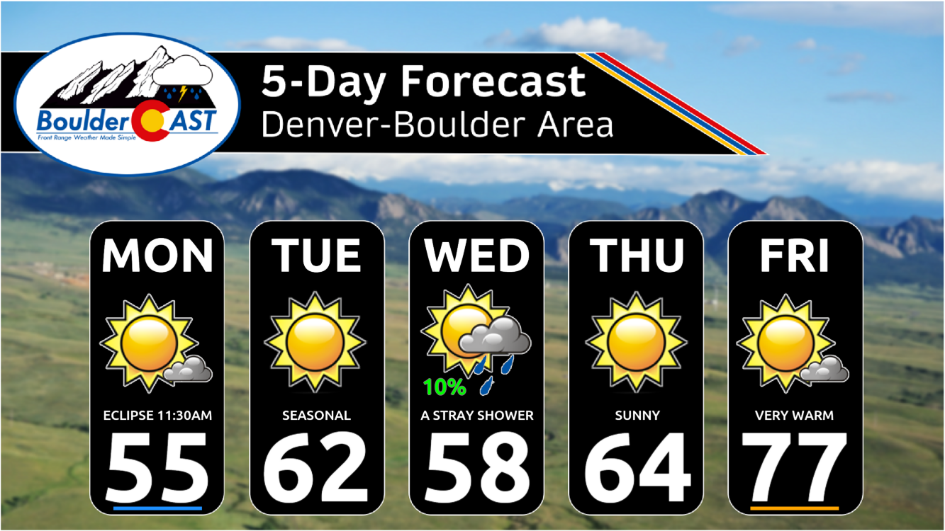
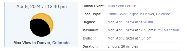
- Solar Eclipse Viewing Monday: On Monday, there will be a partial solar eclipse visible in our area. The eclipse will begin around 11:30 AM and end by 2:00 PM, with about 71% totality observed from the Front Range. Good viewing conditions are anticipated despite some possible mid and high-level clouds.
- This Week’s Weather Forecast: The week is expected to be quieter after a very windy weekend, with temperatures fluctuating between the 50s and 70s. A southern-track low pressure will bring minor impacts mostly confined to southern Colorado. A weak cold front on Wednesday will bring a slight chance of showers, the only precipitation chance for the week.
- Fire Danger Increases by the Weekend: A ridge will build across the Rockies late in the week with temperatures pushing well above normal. The upcoming weekend is likely to be dry, very warm, and gusty — Red Flag Warnings are likely Saturday and Sunday due to elevated fire danger
DISCLAIMER: This weekly outlook forecast is created Monday morning and covers the entire upcoming week. Accuracy will decrease as the week progresses as this post is NOT updated. To receive daily updated forecasts from our team, among many other perks, subscribe to BoulderCAST Premium.

Go Premium, get all the perks.
Daily Forecast Updates
Get our daily forecast discussion every morning delivered to your inbox.
All Our Model Data
Access to all our Colorado-centric high-resolution weather model graphics. Seriously — every one!
Ski & Hiking Forecasts
6-day forecasts for all the Colorado ski resorts, plus more than 120 hiking trails, including every 14er.
Smoke Forecasts
Wildfire smoke concentration predictions up to 72 hours into the future.
Exclusive Content
Weekend outlooks every Thursday, bonus storm updates, historical data and much more!
No Advertisements
Enjoy ad-free viewing on the entire site.
Mostly sunny for Monday’s solar eclipse
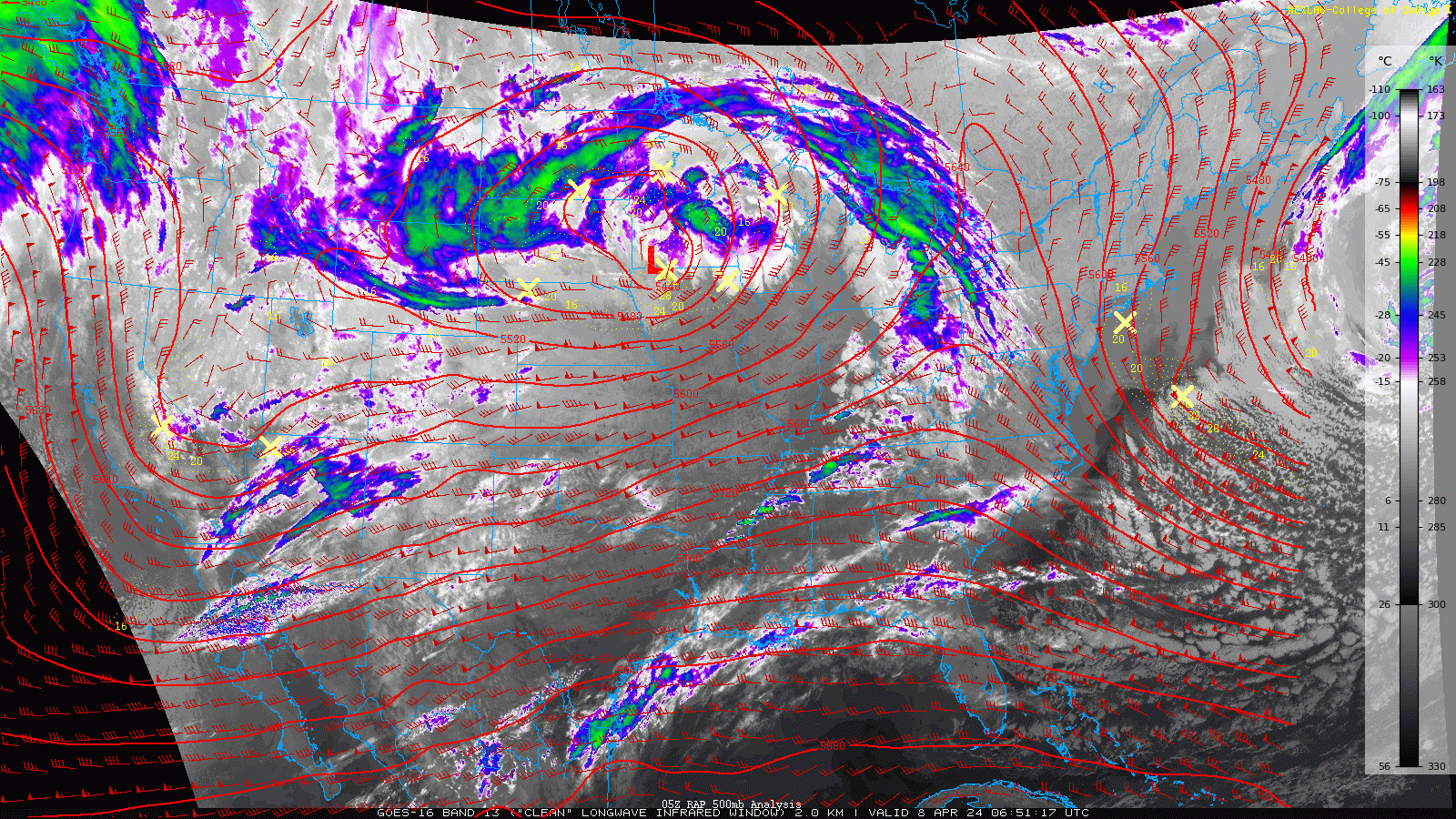
We begin the week between storm systems in Colorado with relatively quiet weather expected for our Monday. The strong storm system which brought us the near 100 MPH wind gusts over the weekend (and blizzard conditions to Nebraska) still sits over the northern Great Plains, but it will continue to wobble away from our area into the Great Lakes. Another mid-level low pressure is developing near Las Vegas as of Monday morning. This southern-track low will move across far southern New Mexico this week leading to just minor impacts in Colorado — and most of those will be confined to southern parts of the state.
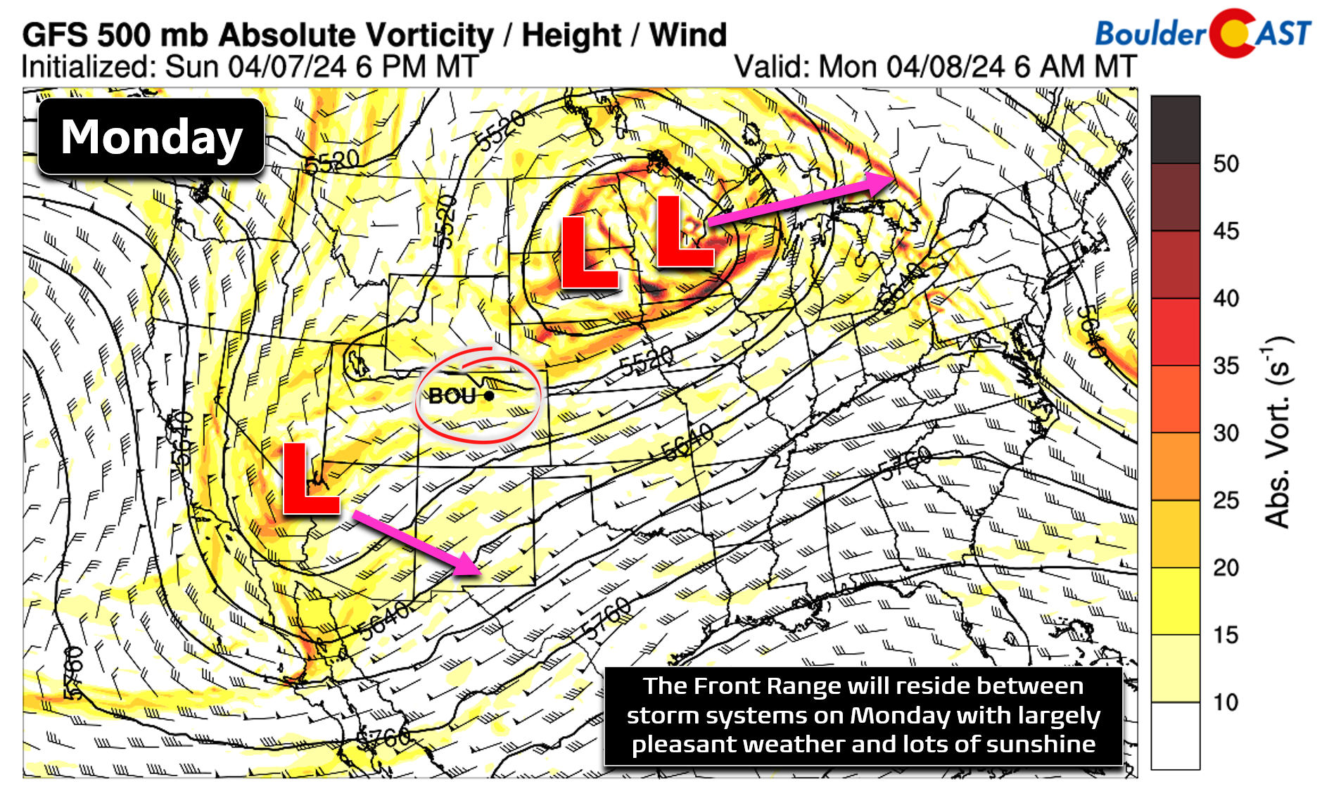
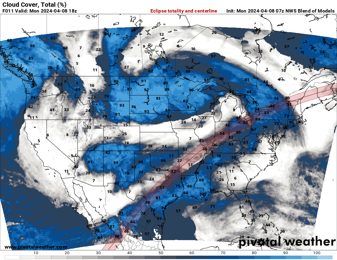
Current GOES-East infrared satellite imagery shows mostly clear skies over northern Colorado as we sit between the two storm systems. Note the extensive cloud cover to our north in Wyoming and to our south in New Mexico/Arizona.
Given this setup, we are expecting partly to mostly sunny skies for our Monday across the Boulder-Denver area with high temperatures in the 50s again. Winds will generally be light throughout the day — a welcomed change from the recent relentless downslope winds!
The anticipated sunny skies should offer fairly good viewing of the partial solar eclipse around lunchtime on Monday, despite a few patches of mid and high level clouds around. Though the path of totality is more than 700 miles away from Denver, we’ll still see about 71% of totality here in the Front Range with the eclipse beginning around 11:30AM Monday morning and wrapping up by 2:00PM. Try to catch a peek if you can — but never look directly at the sun!
The best eclipse viewing in the nation along the path of totality will be in parts of Arkansas, Missouri, and into New England where skies will be mostly clear. The worst viewing will be in New York, Ohio and Texas where plentiful clouds will likely spoil the celestial party.
Mostly quiet weather this week, fire danger for the weekend
Generally tranquil weather will continue for the rest of the week ahead in the Front Range. Really the only concern for the area in the extended is the southern-track low pressure that will move across southern New Mexico Tuesday into Wednesday. As mentioned earlier, basically all of the clouds and precipitation chances with this system will remain along and south of the Palmer Divide, with dry and seasonal weather expected in the Metro area. A weak cold front will pass through the area early Wednesday but it should be a dry passage here. There will be just a slight chance of showers on Wednesday. High temperatures will be in the lower 60s Tuesday before falling back into the upper 50s Wednesday behind the “cold” front.
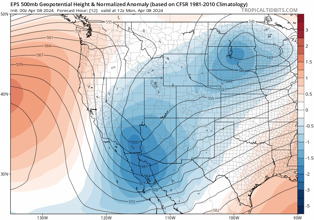
As shown in the a European ensemble 500mb height anomaly animation above which runs through Friday, after the New Mexico low heads east, a ridge will build in across the Rockies later in the week. This will bring continued dry conditions with temperatures trending upwards. Highs will return to the 60s by Thursday and then to the 70s by Friday.
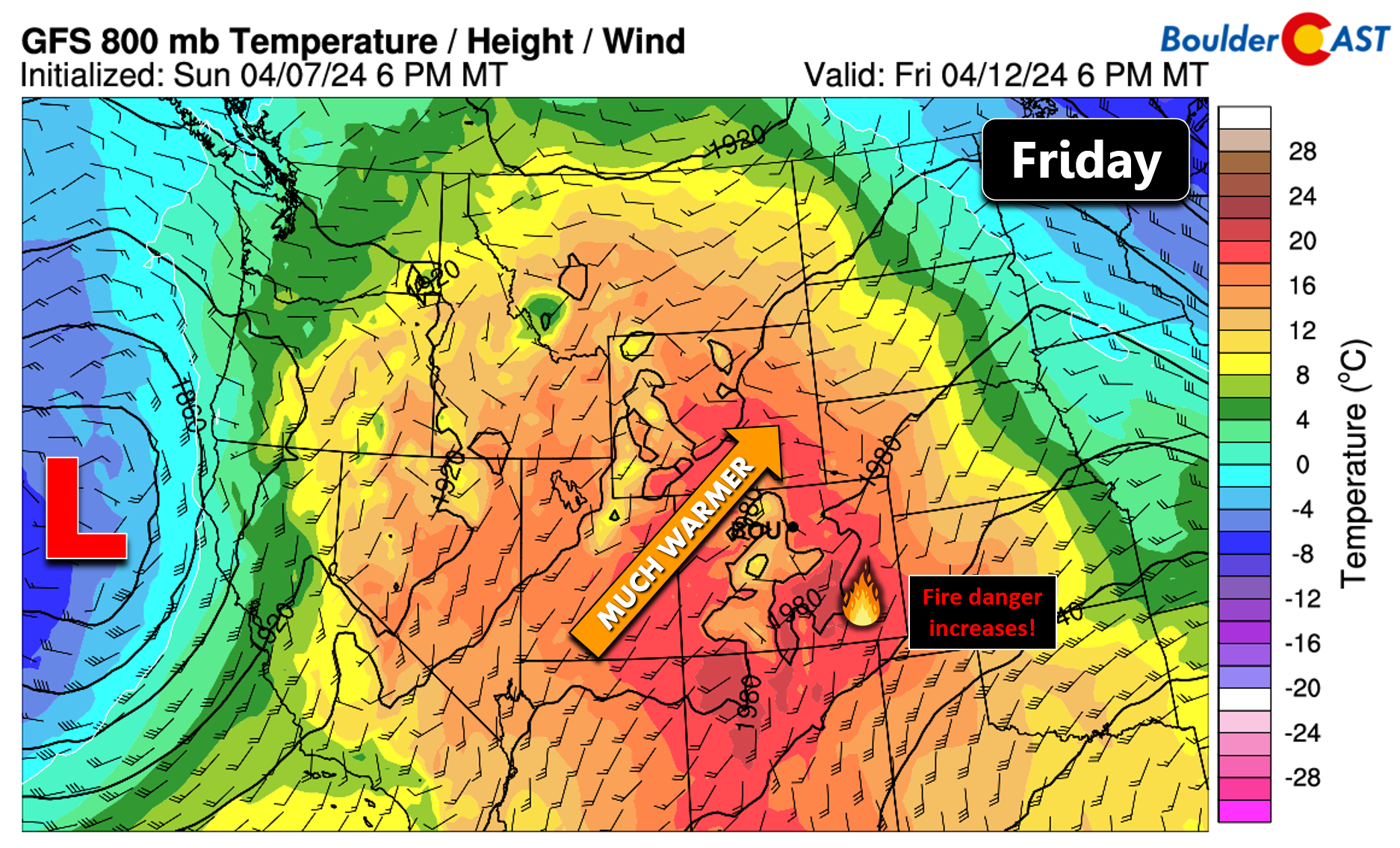
As the next Pacific trough approaches during the upcoming weekend, Colorado will reside under increasingly strong southwest flow aloft which will aid in drying things out and increasing our daytime winds. All signs currently point to a mostly dry, very warm and gusty weekend ahead with fire danger on the rise. Both Saturday and Sunday are likely candidates for Red Flag Warnings with temperatures in the 70s to possibly even the lower 80s. Enjoy the relatively quiet week of springtime weather!
Get BoulderCAST updates delivered to your inbox:
Forecast Specifics:
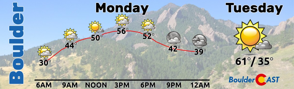
Monday: Partly to mostly sunny skies with temperatures topping out in the middle 50s on the Plains and in the lower 40s in the Foothills. Though they may be some patchy high clouds around, everyone should be able to see the partial solar eclipse which last from 11:30AM to 2PM Monday.
Tuesday: Sunny, mild and seasonal with temperatures reaching the lower 60s on the Plains and near 50 in the Foothills.
Wednesday: Slightly cooler behind an early morning cold front. Partly cloudy with a slight chance of rain showers. Highs in the mid to upper 50s on the Plains with middle 40s in the Foothills.
Thursday: Sunny and quiet as a ridge begins to build into the area. Highs reach the low to middle 60s on the Plains with lower 50s in the Foothills.
Friday: Mostly sunny, very warm, dry and possibly gusty. Fire danger may be elevated. Highs in the mid to upper 70s on the Plains with middle 60s in the Foothills.
DISCLAIMER: This weekly outlook forecast is created Monday morning and covers the entire upcoming week. Accuracy will decrease as the week progresses as this post is NOT updated. To receive daily updated forecasts from our team, among many other perks, subscribe to BoulderCAST Premium.
Go Premium, get all the perks.
Daily Forecast Updates
Get our daily forecast discussion every morning delivered to your inbox.
All Our Model Data
Access to all our Colorado-centric high-resolution weather model graphics. Seriously — every one!
Ski & Hiking Forecasts
6-day forecasts for all the Colorado ski resorts, plus more than 120 hiking trails, including every 14er.
Smoke Forecasts
Wildfire smoke concentration predictions up to 72 hours into the future.
Exclusive Content
Weekend outlooks every Thursday, bonus storm updates, historical data and much more!
No Advertisements
Enjoy ad-free viewing on the entire site.
Enjoy our content? Give it a share!


You must be logged in to post a comment.