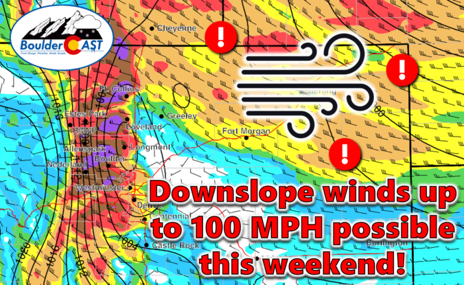
An exceptionally strong spring storm is approaching Colorado which will develop into a big ol’ blizzard in the coming days. However, unlike the last few storms which have been direct hits on the Front Range, this one will track further north leading to more wind than precipitation in our area. After a warm and gusty Friday with high fire danger, the incoming storm will bring colder temperatures and a brief chance of rain/snow showers on Saturday. The biggest impacts from this system, though, will come in the form of prolonged damaging downslope winds. We take a look at the large-scale atmospheric setup and discuss the potential snowfall amounts and which unlucky areas have a chance at wind gusts up to 100 MPH this weekend.

Go Premium, get all the perks.
Daily Forecast Updates
Get our daily forecast discussion every morning delivered to your inbox.
All Our Model Data
Access to all our Colorado-centric high-resolution weather model graphics. Seriously — every one!
Ski & Hiking Forecasts
6-day forecasts for all the Colorado ski resorts, plus more than 120 hiking trails, including every 14er.
Smoke Forecasts
Wildfire smoke concentration predictions up to 72 hours into the future.
Exclusive Content
Weekend outlooks every Thursday, bonus storm updates, historical data and much more!
No Advertisements
Enjoy ad-free viewing on the entire site.
O
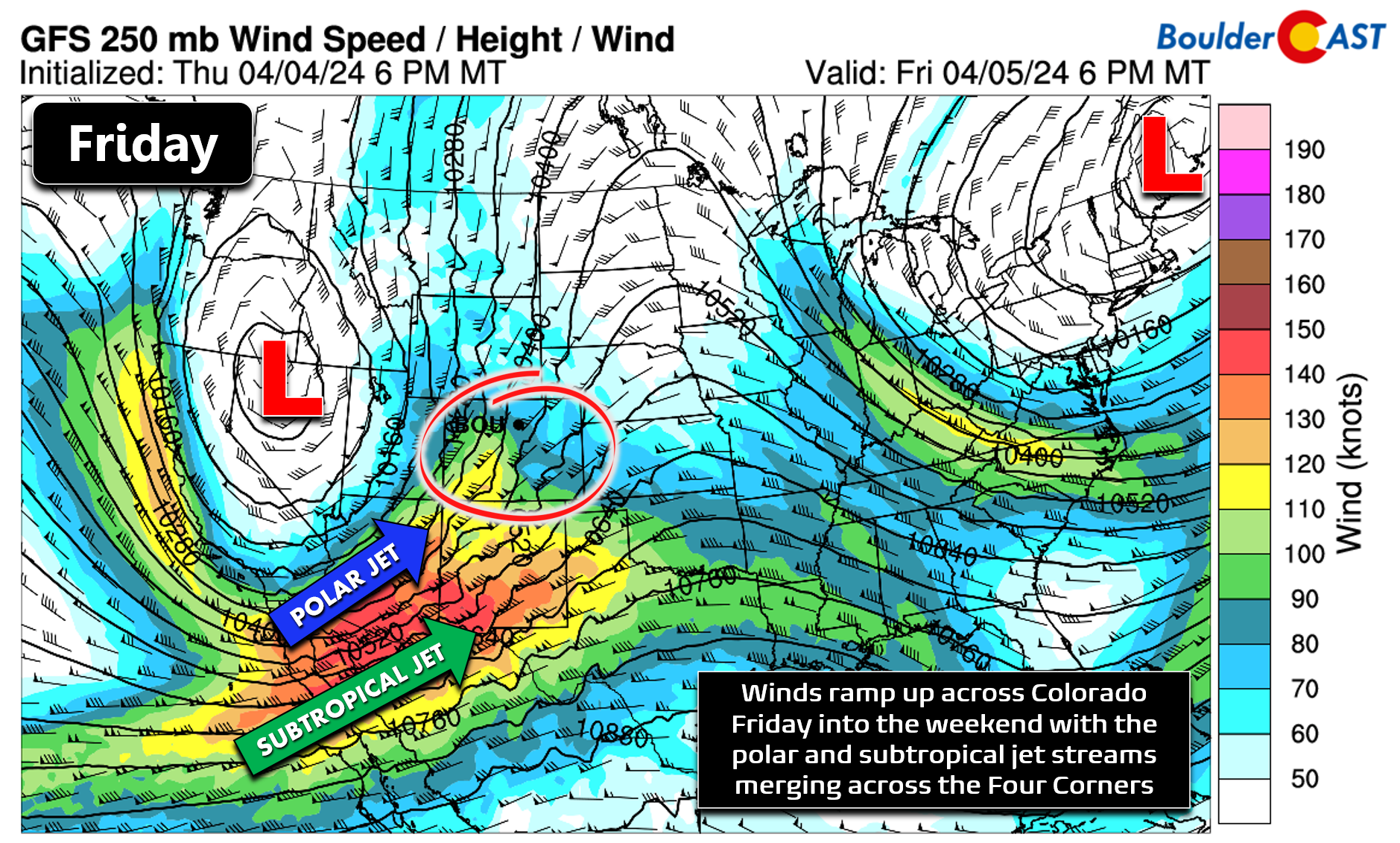
ur next storm system is approaching from the west as of Friday afternoon! The ridge that was overhead the last few days has shifted off into the Midwest. The incoming deep trough has both the polar and subtropical jet streams wrapping around its base, with strong flow aloft entering the Desert Southwest and southern Rockies — yes, here comes the wind!
Ahead of the trough, signs of the southerly moisture influx aloft are noted this morning from the extensive cloud cover over the area.

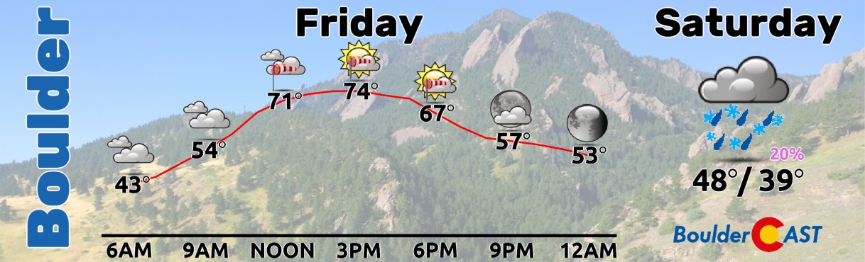
As you might surmise, Friday will be the always-dangerous “warm before the storm” with dry, mild and windy conditions unfolding across the Front Range leading to near-critical fire danger. Red Flag Warnings are in effect for areas along and east of Interstate 25 — this doesn’t include Boulder, but the fire danger will still be elevated here.

Our temperatures will push into the low to middle 70s with cloud coverage decreasing somewhat through the day Friday. Winds will ramp up during the afternoon and early evening with southerly gusts of 20 to 40 MPH possible, with the stronger gusts being east and south of Denver. There’s no chance of rain on Friday so enjoy the nice weather but be extra careful with sparks and flames!
The incoming storm is still expected to track right over Denver on Saturday morning before blowing up into a strong low pressure with blizzard conditions likely across Nebraska and South Dakota the rest of the weekend. This track will not favor our area for much precipitation. There will be a brief chance of rain/snow showers Saturday morning into the early afternoon before booming downslope winds kick in. Most areas will see no snow accumulation at all on Saturday, but up to 1″ may be possible in the heavier showers — this most likely would be east of Denver and away from the terrain.

Sadly, this weekend’s storm will bring more wind than anything for us. Very strong, damaging winds are expected to unfold Saturday afternoon into early Sunday, with lesser but still noticeable winds around the rest of the time. This is shaping up to be a dangerous weekend in the western Metro area, especially around Boulder, where downslope gusts of up to 100 MPH will be possible in the height of a mountain wave event Saturday night into Sunday morning. The model signature for winds this weekend is the strongest we’ve seen seen the day of the Marshall Fire in December 2021.

As of writing on Friday, there is currently a High Wind Watch in effect everywhere which will certainly morph into a High Wind Warning soon. Damaging wind gusts are expected this weekend regionwide. Power outages, downed trees, blowing dust, and rapid fire spread are all concerns with winds this strong! Xcel is already saying they may need to cut power to certain areas to help prevent fire ignitions. Don’t forget, a downed Xcel powerline was ultimately partially blamed as a cause for the Marshall Fire.

Here’s our breakdown of expected conditions this weekend:
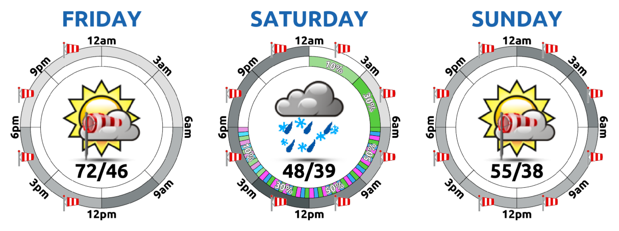
- Friday: Gusts of 20 to 40 MPH from the south regionwide. Combined with warm/dry conditions in the 70s, fire danger will be near-critical. Use extreme caution!
- Saturday: A cold front will blow through around late-morning with a brief period of rain/snow showers possible. Gusty winds may create short-lived whiteout conditions, but less than 1″ is expected in areas that see snow. Many of us will be largely dry. Wind gusts of 30 to 60 MPH will follow the front from the west-northwest. Highs on Saturday will be in the morning near 50 degrees, falling as the front arrives into the 30s
- Saturday Evening into Early Sunday: The most widespread and strongest winds will be during this time as a mountain wave develops. West winds will gust up to 60 to 85 MPH in and near the Foothills, with gusts over 105 MPH not out of the question. This includes in and around Boulder. Winds of 45 to 75 MPH will be possible in the Denver area. Saturday night is going to be a rough one for trying to sleep for most areas. Good luck! Damage from the winds is most likely to occur during this overnight period with downed trees, branches and power lines expected. Xcel Energy has indicated they may cut power to some areas to prevent wildland fire ignitions during the height of the winds.
- Sunday: Winds begin to decrease in intensity by Sunday morning but remain strong, especially in and near the Foothills. Gusts up to 75 MPH will remain in those areas, but decrease elsewhere down to just gusty levels (less than 35 MPH). Sunday will be partly cloudy with highs in the 50s. Sunday is definitely the better of the two weekend days, but it is still not going to be great.
📊 Probabilities for #Boulder to see a least one wind gust exceeding various thresholds this weekend:
60 MPH: 100%
70 MPH: 95%
80 MPH: 70%
90 MPH: 45%
100 MPH: 15%
110 MPH: <5%#COwx #HighWindWarning #RedFlagWarning #Boulderwx #ChinookWind #BoraWind #Colorado #DEnver pic.twitter.com/1BqEEqt7In— BoulderCAST Weather 🏔️❄️ (@BoulderCAST) April 6, 2024
That’s all we have for now. Batten down the hatches. Secure loose objects around your home and yard and prepare for possible power outages! If you don’t like wind, this weekend certainly won’t be for you. Try to make the best of yet another not-so-great weekend in Colorado weather!
Get BoulderCAST updates delivered to your inbox:
Go Premium, get all the perks.
Daily Forecast Updates
Get our daily forecast discussion every morning delivered to your inbox.
All Our Model Data
Access to all our Colorado-centric high-resolution weather model graphics. Seriously — every one!
Ski & Hiking Forecasts
6-day forecasts for all the Colorado ski resorts, plus more than 120 hiking trails, including every 14er.
Smoke Forecasts
Wildfire smoke concentration predictions up to 72 hours into the future.
Exclusive Content
Weekend outlooks every Thursday, bonus storm updates, historical data and much more!
No Advertisements
Enjoy ad-free viewing on the entire site.
Enjoy our content? Help us out and give it a share:


You must be logged in to post a comment.