The last week of April will undoubtedly be an interesting one weatherwise across the Front Range as a potent spring storm bears down on Colorado in the coming days. While we still have some concerns about the storm’s track and exactly how low snow levels will come, this will be a classic upslope event with impacts ranging from thunderstorms to soaking rain to heavy wet snow for our area. Furthermore, there will also be another smaller but colder storm late in the week with accumulating snow chances. The Front Range forecast this week sure is busy! Let’s get into it.
This week’s highlights include:
- Monday will be seasonal with a slight chance of evening thundershowers
- A powerful cut-off low pressure system dives in Colorado on Tuesday bringing widespread upslope precipitation to the Front Range beginning in the afternoon
- Heavy snow accumulations are expected in the Foothills (perhaps more than a foot), but a lack of truly cold air means mostly rain across the lower elevations
- Still some uncertainty in the exact storm track and temperatures which will make for a tricky forecast — mainly regarding how much snow will occur across the Metro area?
- Staying somewhat cool and unsettled the rest of the week into the weekend, with another quick shot of accumulating snow possible Thursday night into Friday morning
DISCLAIMER: This weekly outlook forecast is created Monday morning and covers the entire upcoming week. Accuracy will decrease as the week progresses as this post is NOT updated. To receive daily updated forecasts from our team, among many other perks, subscribe to BoulderCAST Premium.

Go Premium, get all the perks.
Daily Forecast Updates
Get our daily forecast discussion every morning delivered to your inbox.
All Our Model Data
Access to all our Colorado-centric high-resolution weather model graphics. Seriously — every one!
Ski & Hiking Forecasts
6-day forecasts for all the Colorado ski resorts, plus more than 120 hiking trails, including every 14er.
Smoke Forecasts
Wildfire smoke concentration predictions up to 72 hours into the future.
Exclusive Content
Weekend outlooks every Thursday, bonus storm updates, historical data and much more!
No Advertisements
Enjoy ad-free viewing on the entire site.
A powerful spring storm slams Colorado Tuesday into Wednesday
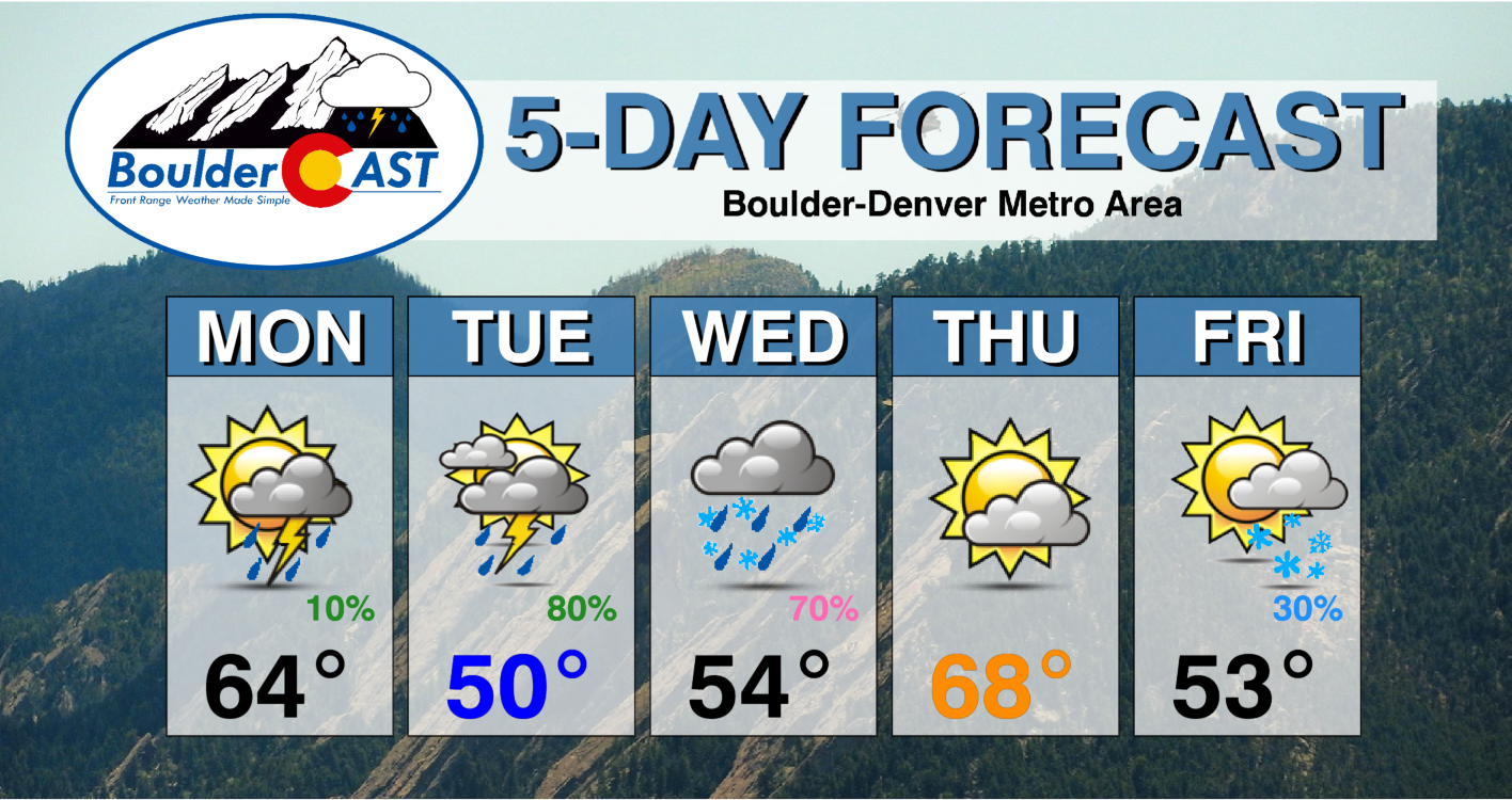
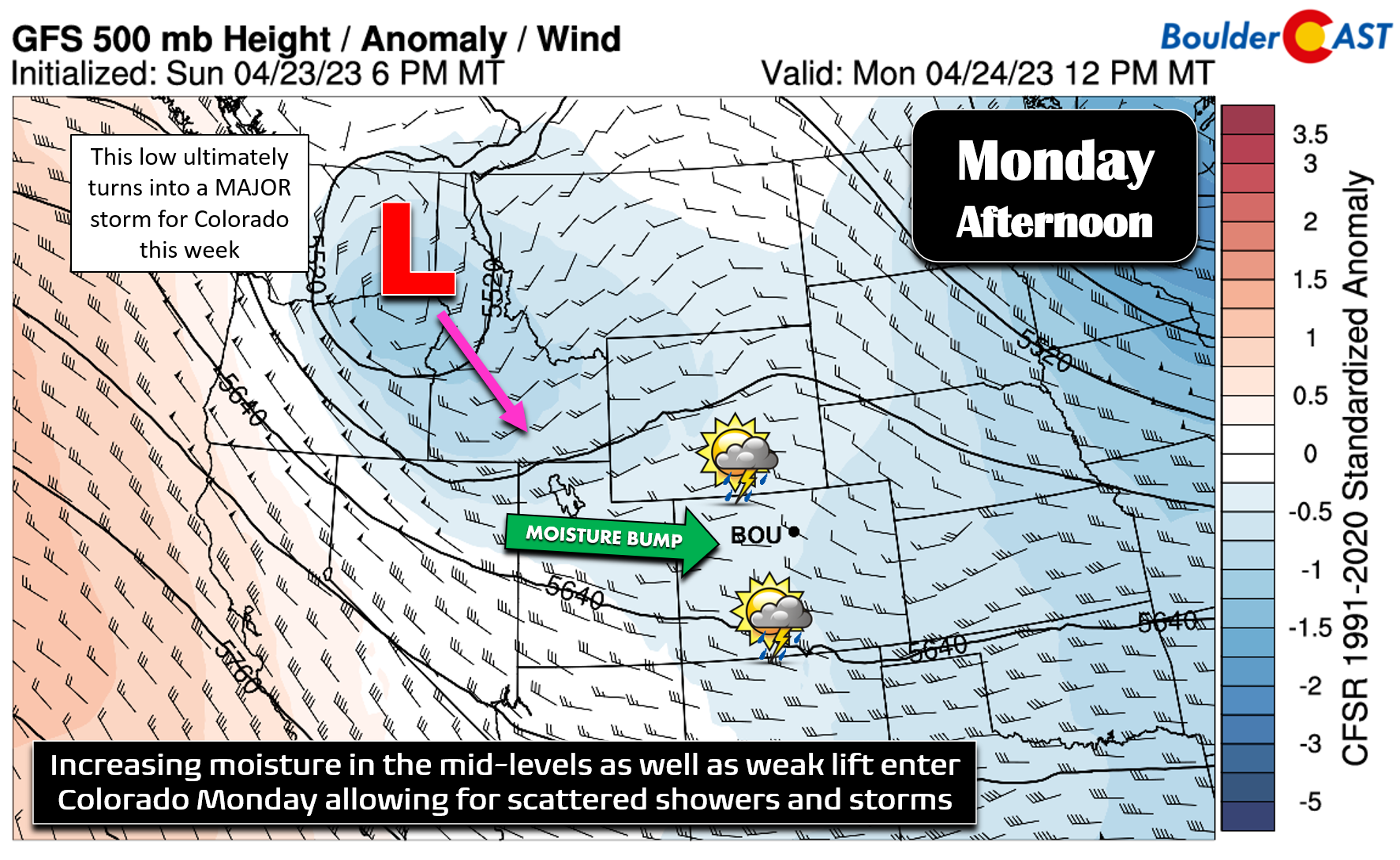
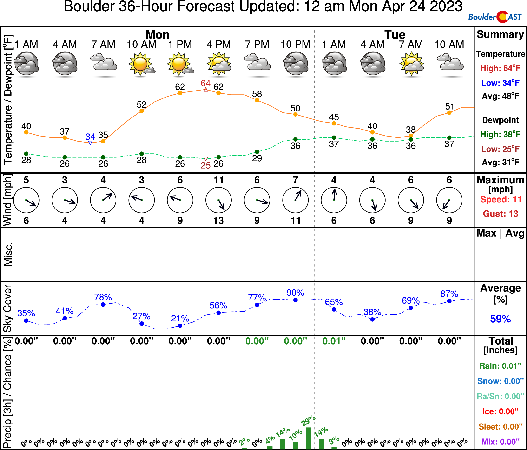
The week commences with continued cool and unsettled weather across the Front Range as moisture begins to stream into the area from the west ahead of the big storm of the week which has just come ashore in the Pacific Northwest. A combination of weak large-scale lift, some instability and this moisture bump will lead to the development of scattered showers across Colorado Monday into Monday night. Some of these showers may spread into the Denver Metro area, mainly during the evening and towards the midnight hour.
For Monday, expect highs in the middle 60s with widely scattered late-period thundershowers — we’re only going with a ~10% chance of rain — with the best chance coming during the late evening to around midnight.
Things REALLY get interesting on Tuesday as the highly anticipated cut-off low pressure system enters Colorado from the northwest and eventually moves into prime position later in the day. This event, by all indication, will check every box for a classic upslope spring storm. Well, that is every box but one!
Four Corners low ✅
The animation below shows the forecast track of the mid-level low pressure over next 48 hours or so from Monday morning into Wednesday morning.
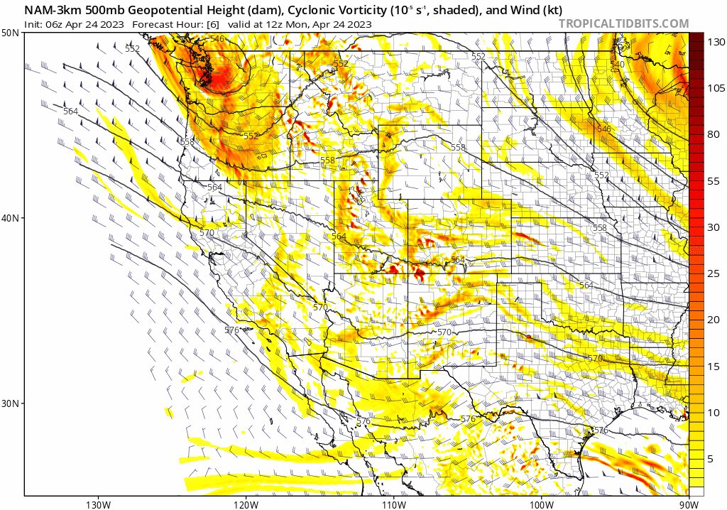
While not exactly a textbook example of a Four Corners Low which would generally arrive to southwest Colorado by way of California or Nevada first, this storm will end up in largely the same location.
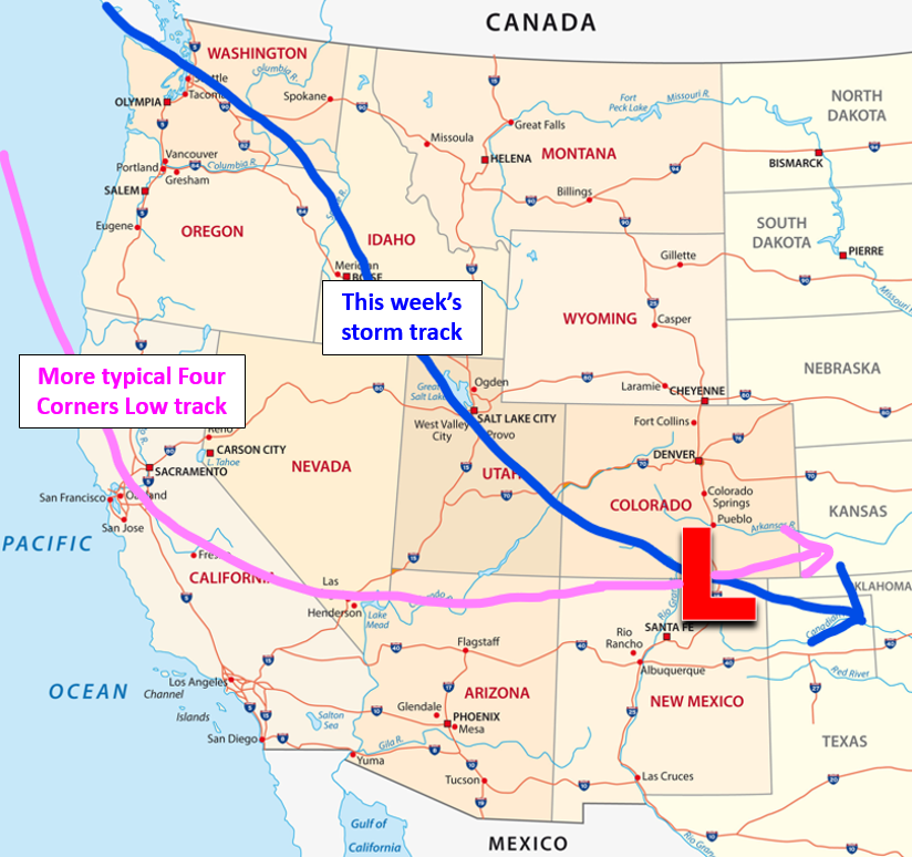
When it comes to weather, the means don’t matter nearly as much as the end result — in this case, the result will be a big low pressure sitting directly south of Denver. The counter-clockwise winds around a low pressure in this position equate to Front Range upslope!

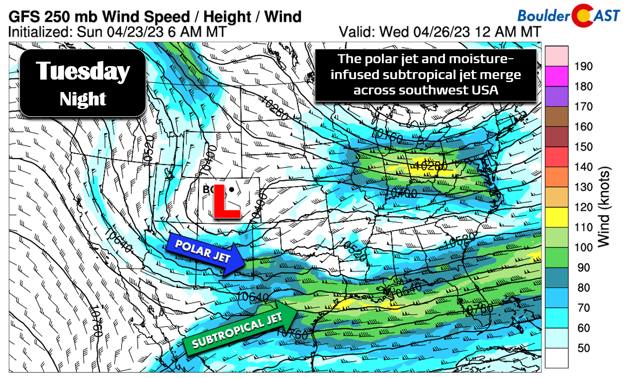
Deep and intense easterly flow for an extended period? ✅
As the low pressure dives into southwest Colorado on Tuesday and then straddles the New Mexico border Tuesday evening and night, juicy upslope will ensue across almost all of Colorado from Fort Collins up north to Trinidad down south!
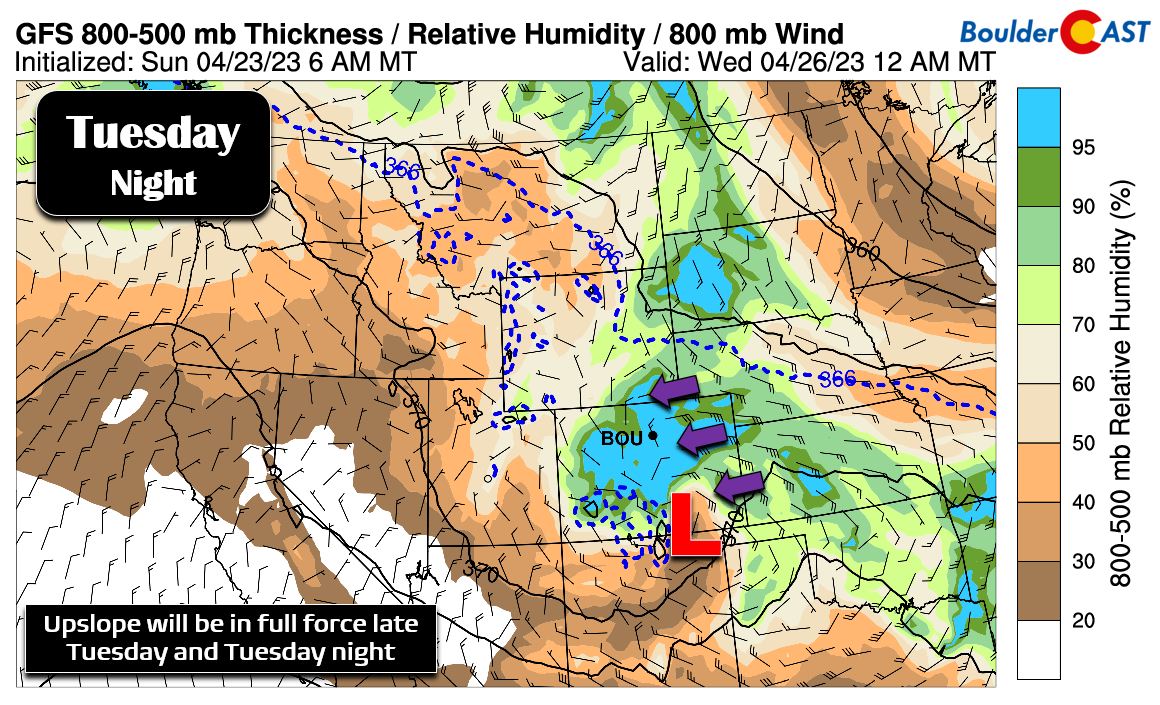
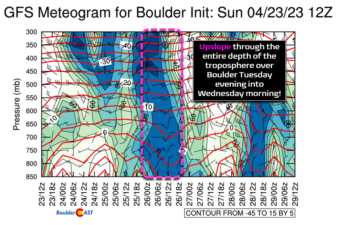
The time-height forecast plot of winds and relative humidity below for Boulder shows that the upslope won’t just be present in the lower atmosphere — as is usually the case for most run-of-the-mill storms — but instead upslope will stretch from the surface nearly all the way up to the stratosphere!
All of that air blowing directly into the Continental Divide will help to wring out the moisture in the form of bountiful precipitation regionwide…
Plentiful moisture influx? ✅
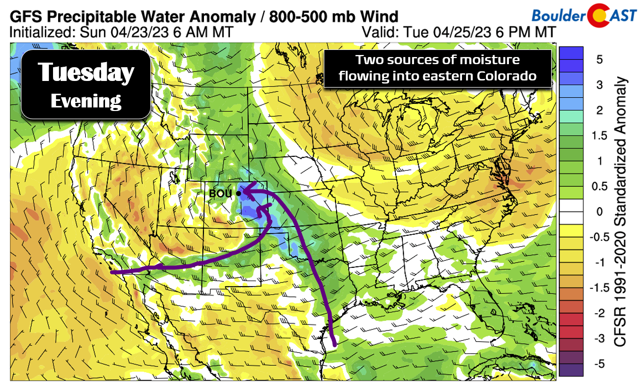
There will be two main sources of moisture feeding into this messy spring storm this week, together bringing moisture levels to near record level for late April in eastern Colorado.
1) A plume of Pacific moisture accompanying the subtropical jet stream from the southwest:
2) Low-level Gulf of Mexico moisture getting wrapped back into the system from the south and east:
Okay —so we have a favorable storm track, deep upslope reaching up to the jet stream level, and an atmosphere which will be infused with copious moisture from two source regions. What can possibly go wrong? Well… temperatures.
Cold enough air for snow across the lower elevations? ❌
As the spring season wears on, temperatures become trickier for snow with each passing day. If you were hoping for epic snowfall from this system, we have some bad news to share: it will most likely not pack enough cold air to change rain to snow across Boulder or Denver, at least not in a substantial way.
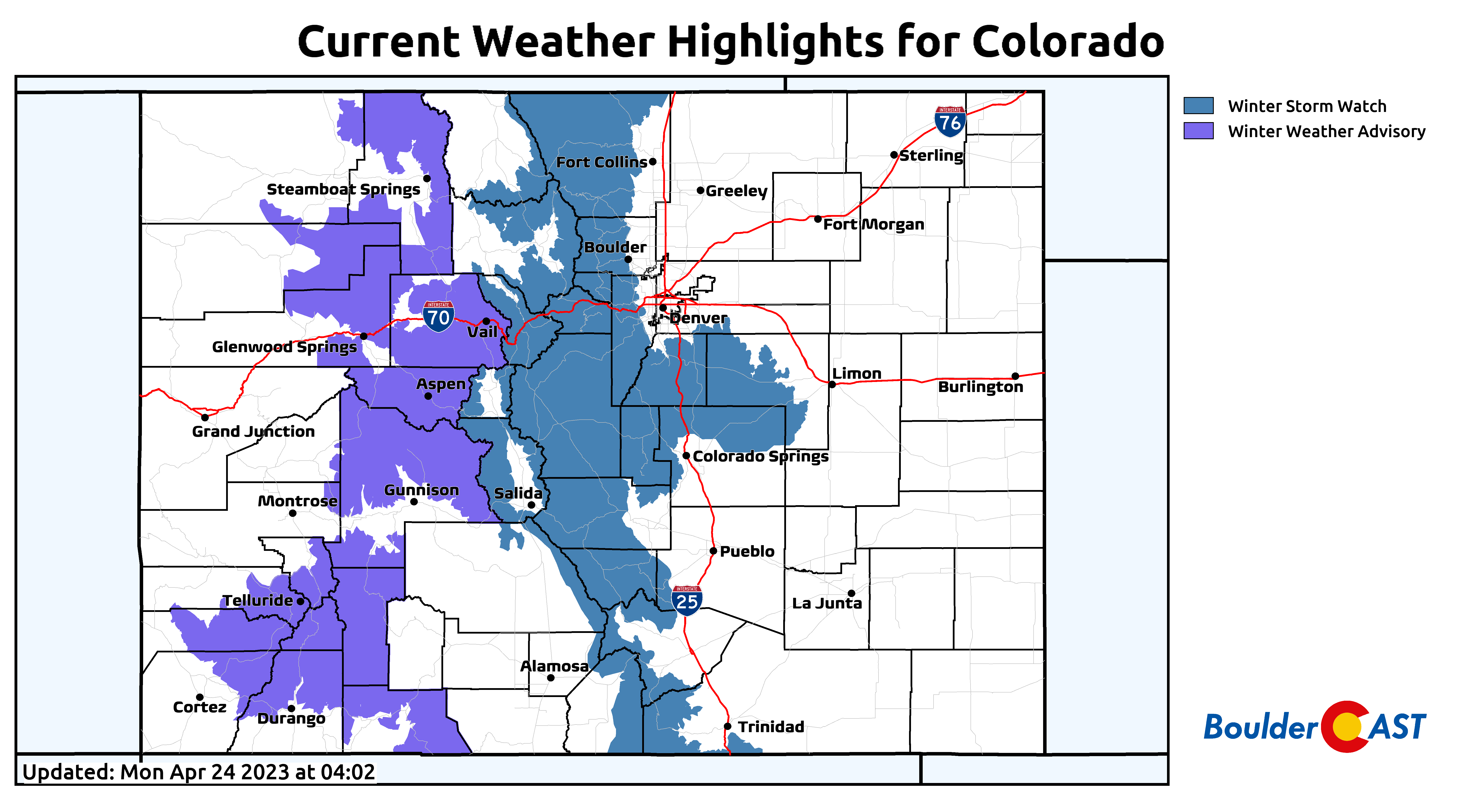
Though this storm is currently forecast to produce 0.75″ to 2″ of precipitation in the Front Range, almost all of that will be falling as a chilly rain below 6000 feet elevation as temperatures fail to cool enough for a change-over to snow. Higher up though, say above 7500 feet elevation, this will be a doozy of a storm with snowfall totals possibly exceeding a foot. Winter Storm Watches are posted already for areas along and EAST of the Continental Divide from the Wyoming border to the New Mexico border in anticipation for a hefty helping of spring upslope snow — that’s always fun to see!
CONCERNS
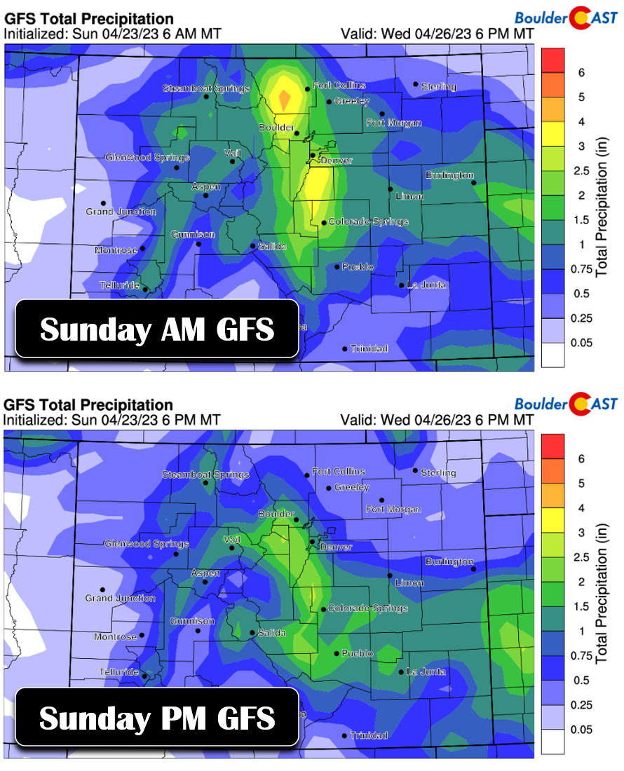
Our number one concern right now is the small-scale nature of the storm system. On the size spectrum of cut-off low pressure systems, this one falls towards the smaller end which would mean that slight track shifts would have bigger implications on the outcome. Over the last day or so we’ve already seen the storm track shift slightly southward, taking the heaviest precipitation with it. There is still a good chance that areas in and near the Front Range Foothills get 1″ (or more) moisture out of this system, but those odds have declined for areas north of Boulder. The probability of 2″ of moisture, as models were once vividly advertising, has declined as well for our entire area. This is definitely a concerning trend, one we hope not to see continue as the storm approaches.
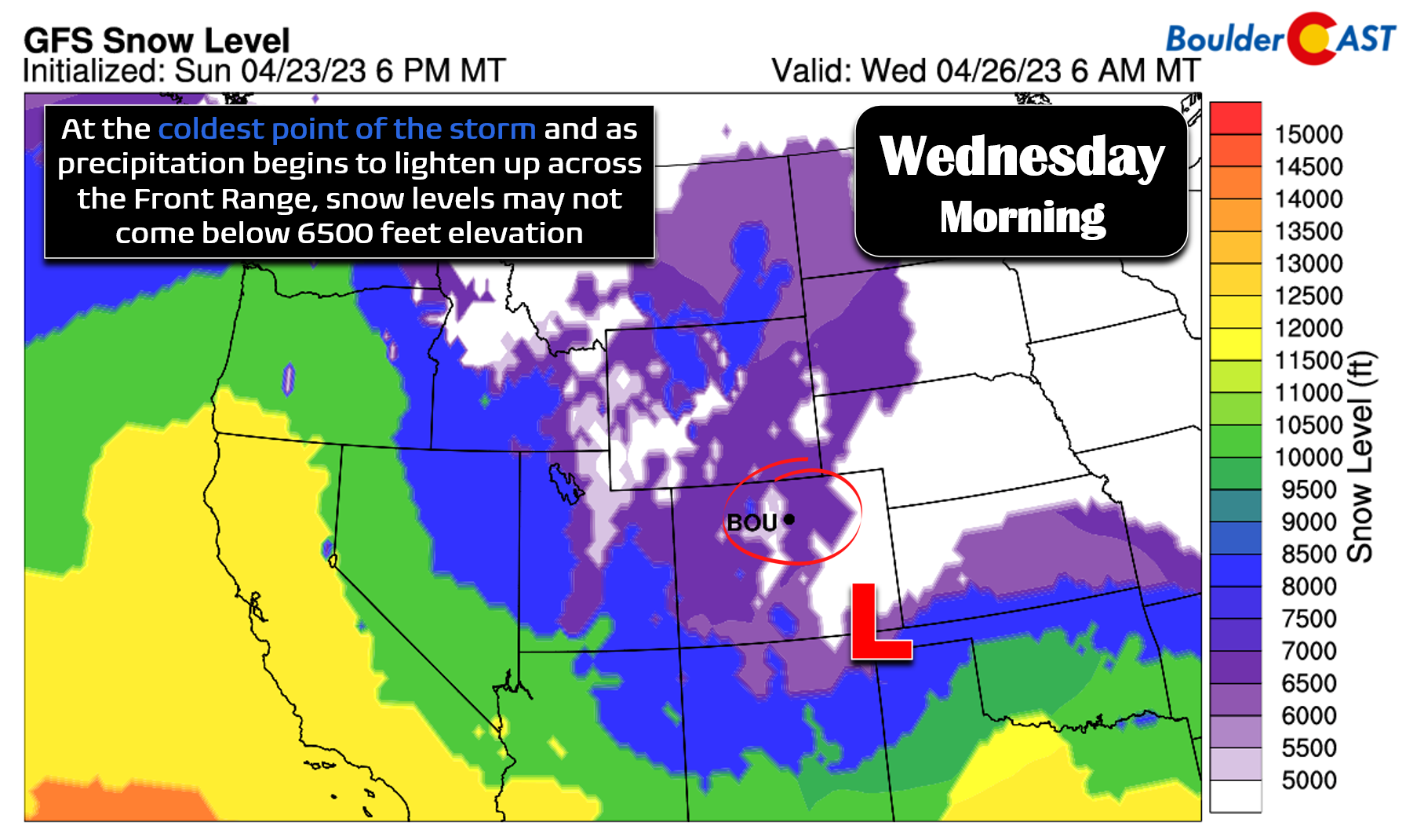
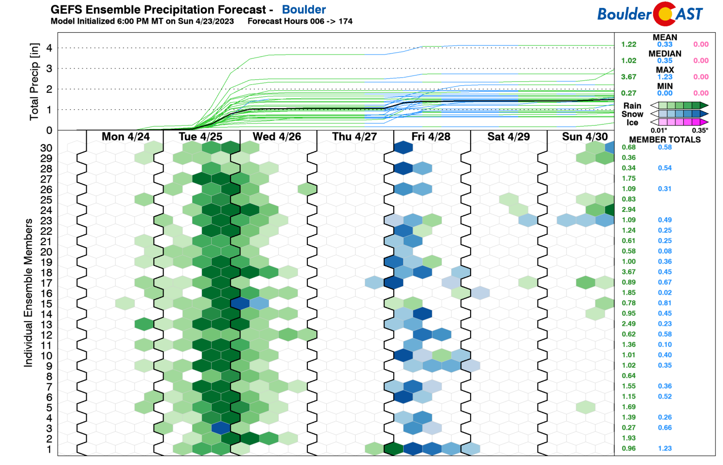
Temperatures are still a bit of a question mark with this storm as well and they will of course be key in determining how far down the snow level comes Tuesday night. Most global model guidance currently keeps things as almost all rain below 6000 feet. For example, less than 5% of GFS ensemble members predict snow in Boulder (see below). However, some of the guidance is coming in cooler (like the NAM, NAM-NEST and HRRR) which indicates a possible change-over to snow late Tuesday night into Wednesday morning. This seems plausible, but definitely isn’t a guarantee. The most likely spots to see some slushy snow accumulations would be areas above 5500 feet elevation. This includes the western and southern fringes of the Denver Metro area, including far western Boulder (west of Broadway), Rocky Flats, Golden, Centennial, and Parker. The absolute coldest scenario would produce 3 to 8″ for these locations, but more likely it will be 0 to 3″.
TIMELINE
Ok, so here’s the rough breakdown of the storm timeline for now…
Tuesday: Temperatures may get into the 50s in the late morning or early afternoon, but widespread rain and some thunderstorms will move into the area through the afternoon and evening. Snow levels will begin high (~9000 feet) but fall quickly to allow for mostly snow in the Foothills above 7500 feet elevation through the afternoon/evening. Travel will decline rapidly in the higher Foothills and Mountains as Tuesday wears on and upslope intensifies! Snowfall rates of 1 to 2″ per hour will be common during the late afternoon/evening making travel difficult in the Mountains and Foothills. All precipitation across the lower elevations will be rain on Tuesday, with some thunder mixed in as instability will be quite high.
Tuesday Night: This will be hammer-time for the storm. Widespread chilly rain will continue across the lower elevations throughout the evening and into the overnight as persistent deep upslope slams into the terrain. The more intense precipitation will start to shift south of the Denver Metro area after midnight, but at least light to moderate precipitation should persist all night. Temperatures will continue to cool with snow levels coming down further through the night, likely bottoming out around ~5500 feet towards the tail-end of the event. There is slight chance that it gets just cold enough for some snow across the lower elevations, but any accumulation should be minor as temperatures would be slightly above freezing and precipitation would be waning by the time it could get cold enough.
Wednesday: Lingering light stratiform rain and/or snow will continue through the morning with the worst shifting off into southern Colorado. Snow levels will creep back up through the day as precipitation comes to an end. We expect drier weather Wednesday afternoon into the evening.
POSSIBLE SNOW AMOUNTS
Due to lingering concerns about the overall storm track taking things further south and the marginal temperatures Tuesday evening/night during the height of the storm, snow amounts are still fairly uncertain. However, here is our current thoughts:
- Foothills above 8000 feet: 6 to 18″, lower towards Estes Park and highest in Jefferson County
- Foothills from 6000 to 8000 feet: 3 to 12″, amounts greatly dependent on elevation
- Palmer Divide: 4 to 10″, but could be higher if the change-over to snow is earlier on Tuesday evening
- Areas below 6000 feet elevation, including Boulder and Denver: 0 to 4″, amounts highest above 5500 feet elevation. Some lower elevation areas like Longmont probably see no snow at all.
Our team will continue to fine-tune the details of this monster storm and provide another forecast update Tuesday morning — be sure to check back.
The rest of the week stays unsettled
As the big storm departs Colorado to the south and east on Wednesday, the latter half of the day should see a drying trend with temperatures warming into the lower 50s.
Thursday should be a mostly dry day and actually not too bad at all with temperatures pushing well into the 60s. This is hands down the nicest day of the week.
Thursday night into Friday morning, both the GFS and Euro models are in good agreement that another cold front will drop south out of Wyoming into Colorado, something similar to what unfolded this past Friday. Frontal lift and jet-forcing may once again combine for a quick burst of moderate snow across the Metro area — yes this late week system would be cold enough for snowflakes for everyone. We won’t cover this potential snow event now as our focus remains on the obviously more impactful storm sitting between now and then. Though we must say that having too many spring storms cluttering up the forecasting pipeline is a good problem to have. Stay tuned!
DISCLAIMER: This weekly outlook forecast is created Monday morning and covers the entire upcoming week. Accuracy will decrease as the week progresses as this post is NOT updated. To receive daily updated forecasts from our team, among many other perks, subscribe to BoulderCAST Premium.
Go Premium, get all the perks.
Daily Forecast Updates
Get our daily forecast discussion every morning delivered to your inbox.
All Our Model Data
Access to all our Colorado-centric high-resolution weather model graphics. Seriously — every one!
Ski & Hiking Forecasts
6-day forecasts for all the Colorado ski resorts, plus more than 120 hiking trails, including every 14er.
Smoke Forecasts
Wildfire smoke concentration predictions up to 72 hours into the future.
Exclusive Content
Weekend outlooks every Thursday, bonus storm updates, historical data and much more!
No Advertisements
Enjoy ad-free viewing on the entire site.
Spread the word, share the BoulderCAST forecast!


You must be logged in to post a comment.