
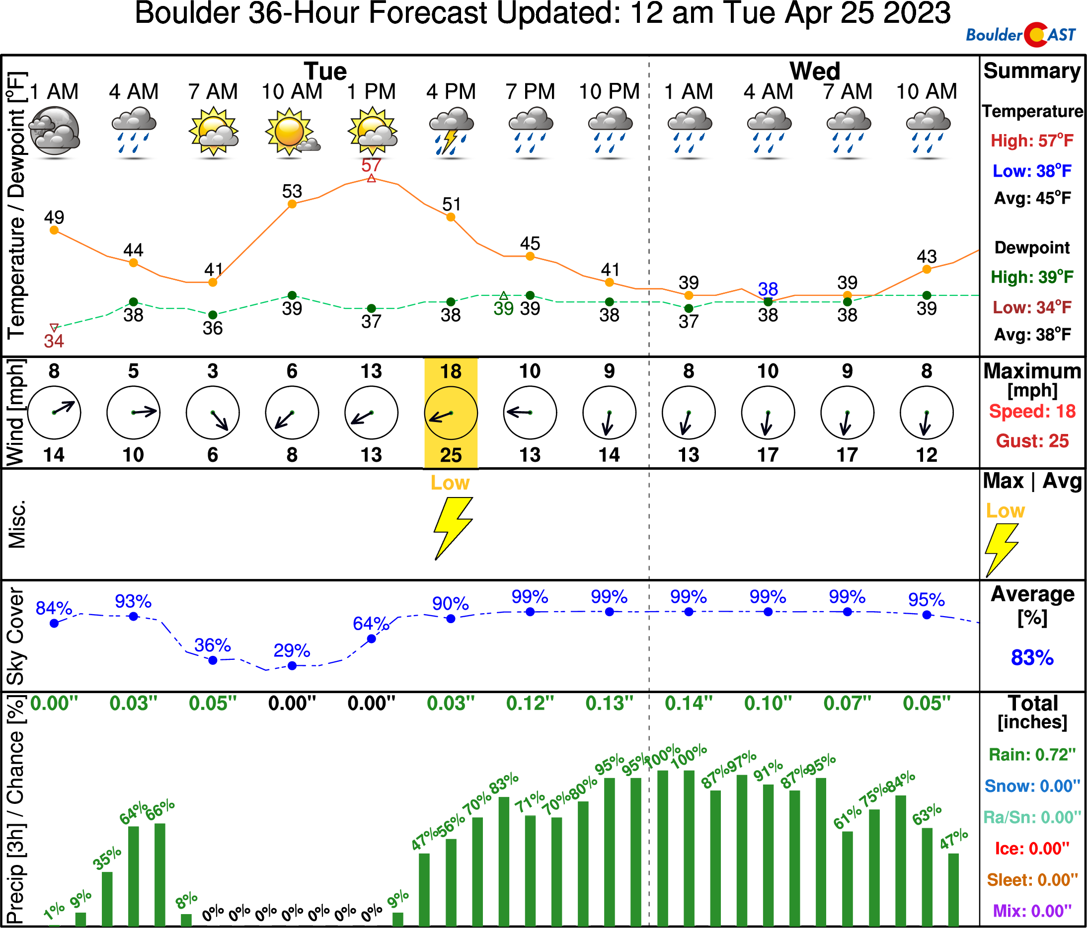
A powerful low pressure system remains on-track to impact the Front Range Tuesday afternoon into Wednesday with several hours of nearly perfect upslope in the works. While there has been a slight southward shift in the storm’s track, we still anticipate widespread soaking rain across the lower elevations and heavy wet snow in the Foothills, including some thunder thrown into the mix. Travel will become extremely difficult Tuesday evening west of town with snowfall rates of 1 to 3″ per hour. Finally, while this event will be almost exclusively just cold rain across the Plains, we may see a little wet snow in the far western and southern Metro area. Read on for all the details.
G
ood Tuesday morning, everyone! The mid-level storm system remains closed-off and is currently positioned near Salt Lake City, just a pitstop on its trek towards southern Colorado by early this afternoon. Out ahead of the system, a few rain showers have spread across our area overnight but have now pushed off to the northeast. You may notice a few small puddles here and there.

Once our storm gets into position across southern Colorado, upslope will commence with strong and moist easterly flow banking up against the terrain east of the Continental Divide. That will happen later on Tuesday.

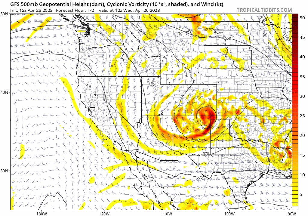
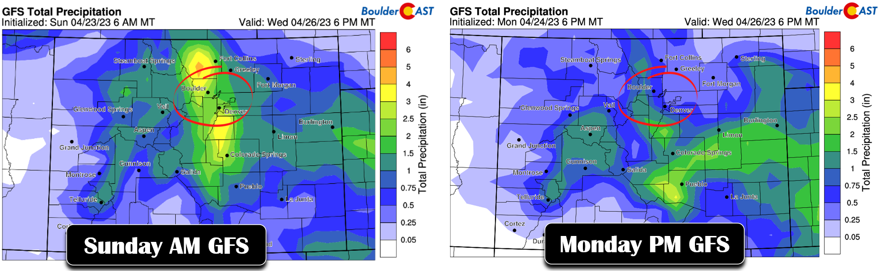
Widespread rain and heavy snow are still on the way to the Front Range, just not quite as much as models were originally advertising. In our forecast update yesterday, our main concern was regarding a notable trend that the storm system was digging slightly further south and due to its smaller size, that southward shift could pull the bullseye of heavier precipitation with it. This trend has unfortunately continued further. The animation below highlights this southward shift over the last 48 hours in the GFS model. This is a 500mb height/vorticity forecast for 6AM on Wednesday from the last two days of GFS model predictions. At one point the low was actually expected to be in far southern Colorado on Wednesday morning. Instead, it now looks like the storm will actually be about 100 miles further south in the Texas Panhandle.
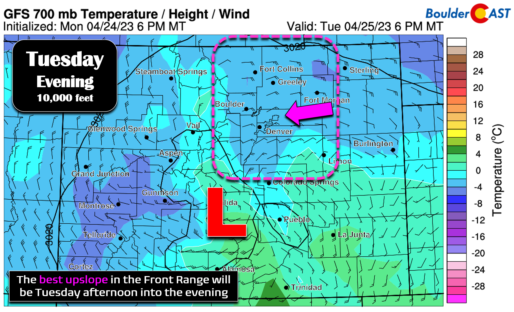
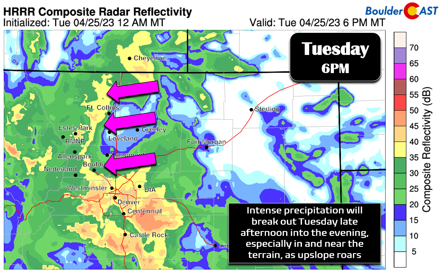
With this slight shift in track, the best and longest-lasting upslope from this relatively compact storm has migrated south as well. The GFS forecast for 6PM on Tuesday at 10,000 feet elevation below indicates what is essentially perfect upslope for the Front Range: 25 to 30 MPH almost due easterly winds blasting into the terrain. Visualizing this wind forecast actually sends a slight chill down my spine knowing what it can do across our area! Widespread moderate to heavy precipitation is extremely likely to be occurring with this setup late this afternoon through the evening hours. Travel in the Mountains and higher Foothills will rapidly become hazardous as snowfall rates of 1 to 3″ per hour can be expected under this upslope setup. Don’t be one of those idiots that will undoubtedly get stranded on I-70 this evening! Across the Denver Metro area, this intense upslope will instead manifest in the form of moderate to heavy rain and even a few thunderstorms.
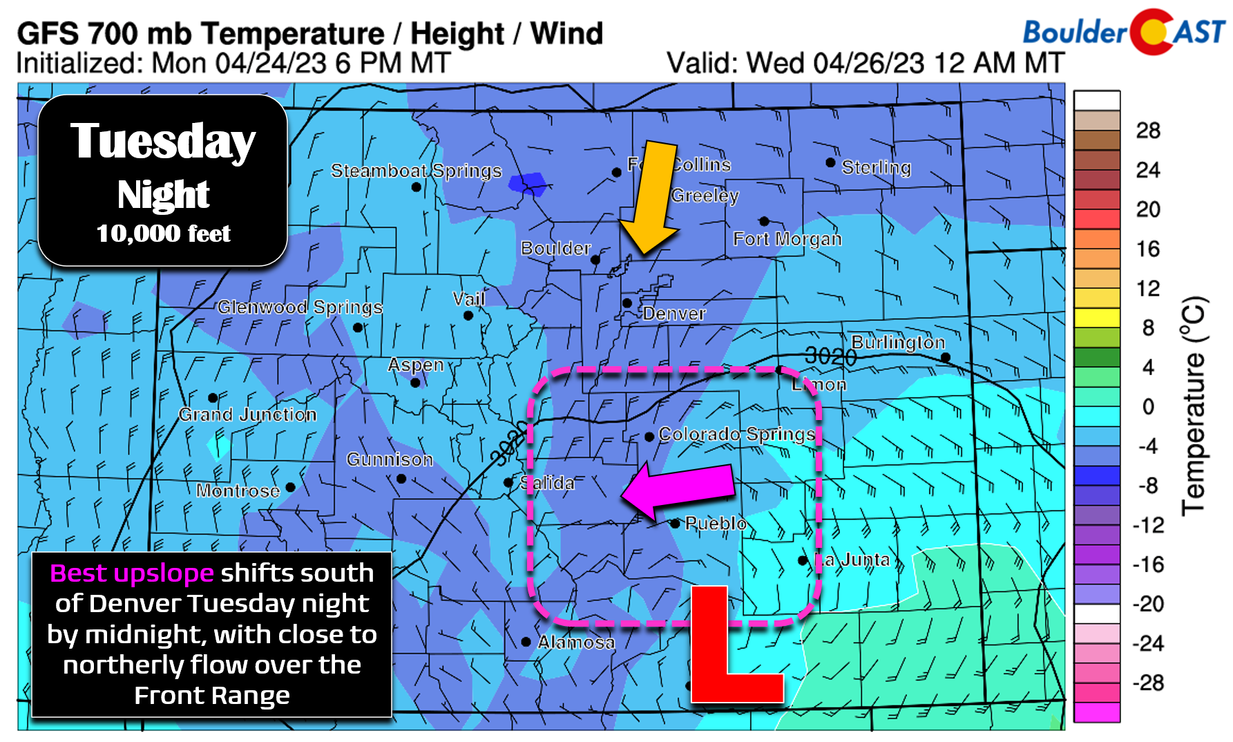
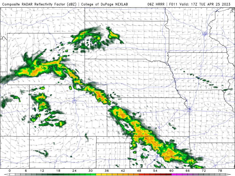
Unfortunately that premiere upslope won’t last all that long here. As the low pressure continues to track south and east, winds will turn closer to northerly over the Front Range essentially killing off the best upslope. The forecast graphic below is for midnight Tuesday night. While precipitation will still be ongoing, it won’t be nearly as intense as it could have been.
In short, over the last 48 hours or so this storm has lost close to 40-50% of its punch in the Front Range. Forecast precipitation amounts originally looked like 1 to 3″, but are now down to approximately 0.5 to 1.5″ for our area. This is certainly still an important storm hydrologically for us — one-inch precipitation events only happen a couple times per year in Boulder, the last being the soggy rain/snow storm back in late December. Still, it’s disappointing to think about what could have been…
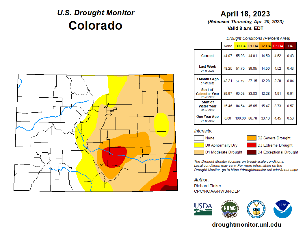
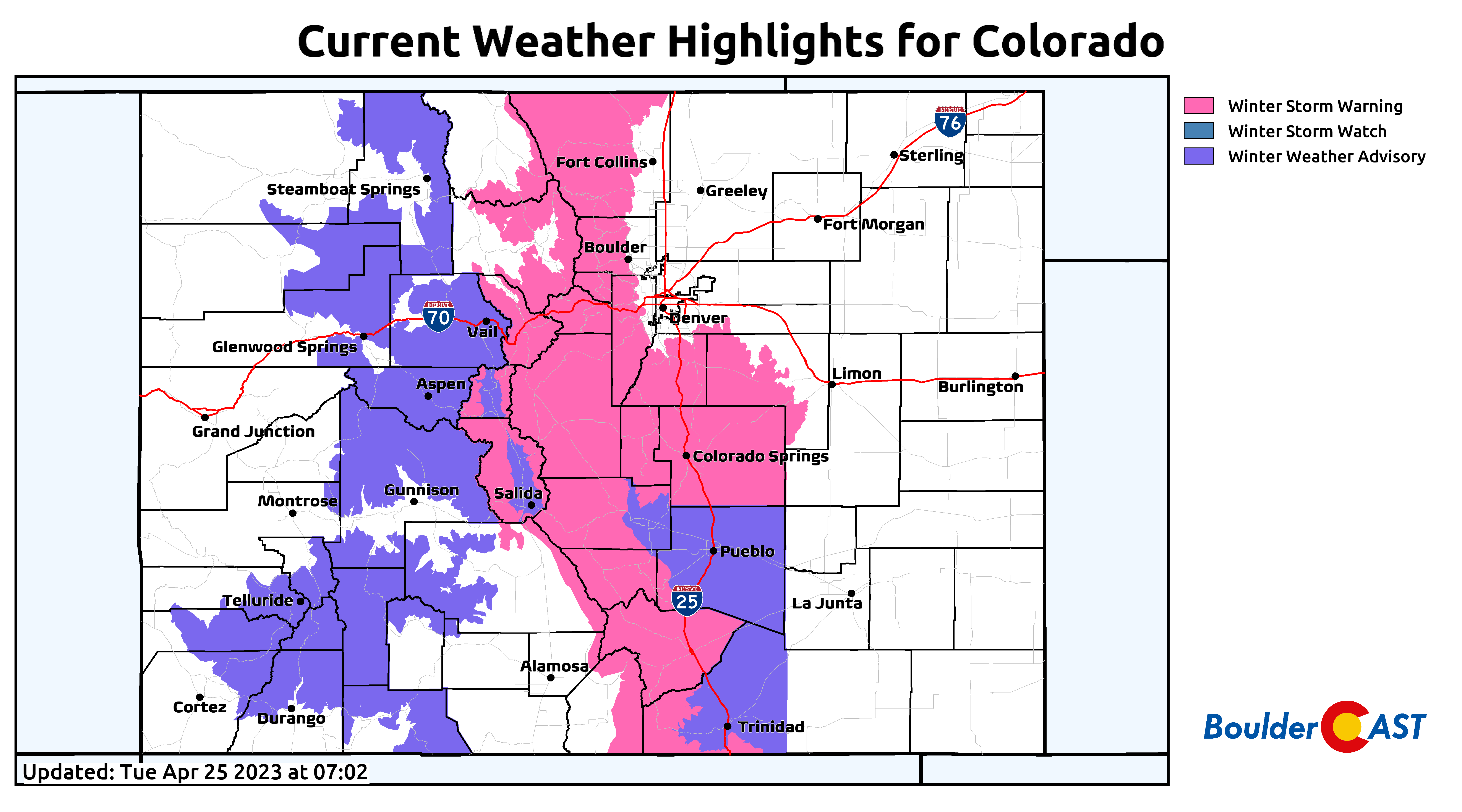
In any case, the southward shift in the bullseye of precipitation will align it more closely with southeast Colorado, an area struggling even worse with drought than Denver. The moisture will be well received!
Despite the perceived shortcomings, this storm will still deliver for our area. As the low pressure moves into position to our south early Tuesday afternoon, upslope will begin to ramp up, maximizing around early to mid-evening. We should see an intense band of precipitation develop parallel to the terrain from late afternoon through the evening as a result. There is some indication that a weak barrier jet could form as well, which would help to spread the precipitation shield further eastward.
Approximately 3PM to Midnight will be primetime for the heaviest snowfall rates in the higher terrain and most intense rainfall rates across the Boulder-Denver area. There could also be some embedded thunderstorms during this time as well, which of course would be thundersnow in the higher terrain! Any storms would be capable of producing small hail and heavy rain.
Temperature profiles will favor almost exclusively snow above 8000 feet elevation, with rain changing to snow between 6000 and 8000 feet, and almost all rain below 6000 feet. Yes, both Boulder and Denver will see just chilly rain as temperatures only bottom out in the middle to upper 30s late Tuesday night into Wednesday morning. Areas above 5500 feet elevation will be a tad colder and could see a mix to snow with possibly up to inch or two of slushy accumulation overnight. The chance is low, but if that happens it won’t cause any real issues for the vegetation or roadways.
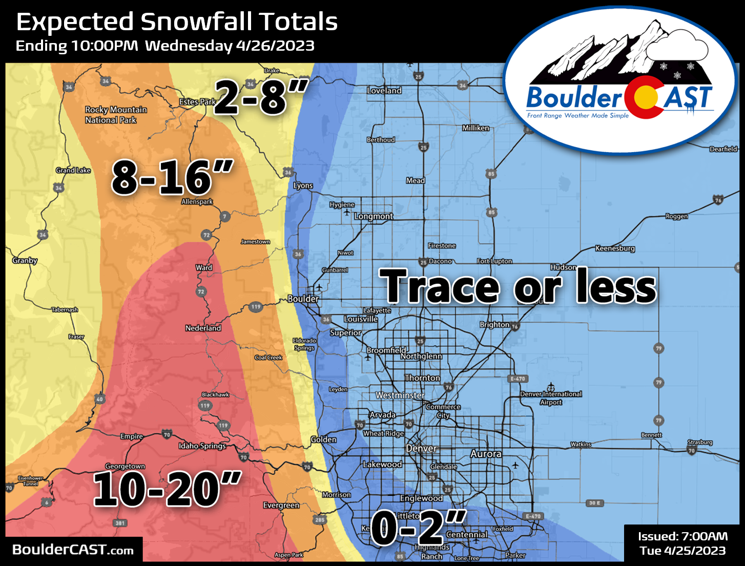
Without further adieu, our snowfall forecast map for the event is shown below. This will certainly be a major storm for the higher Foothills, particularly from Boulder County southward which could see locally up to 2 feet of snow above 8000 feet. Things are much trickier in the lower Foothills where there will be some rain early in the event. Finally, our map also highlights the areas above 5500 feet elevation in the far western and southern Metro area which could see very minor accumulations of up to 2″ (dark blue shading). This includes Lyons, far western Boulder, west Arvada, Golden, Littleton, Roxborough, Centennial, Parker and like areas. Elsewhere, it’s just going to be too warm this time with a trace or less of snow expected. This was a close one though — a few degrees colder and this would have been a much different forecast discussion!
Winter Storm Warnings are posted for much of Colorado right now, including the Front Range Mountains, Foothills, and Palmer Divide. Again, we stress that traveling above ~6500 feet is not recommended late Tuesday afternoon through Wednesday morning. You have been warned!
As the storm moves out on Wednesday, rain/snow will taper off from north to south through the day ending for everyone by afternoon. High temperatures will stay cold only reaching the 40s to lower 50s.
Overall, we’re expecting the Denver area to see north of 0.5″ of moisture from this storm, with totals greater than 1″ favored in Boulder and the Foothills.

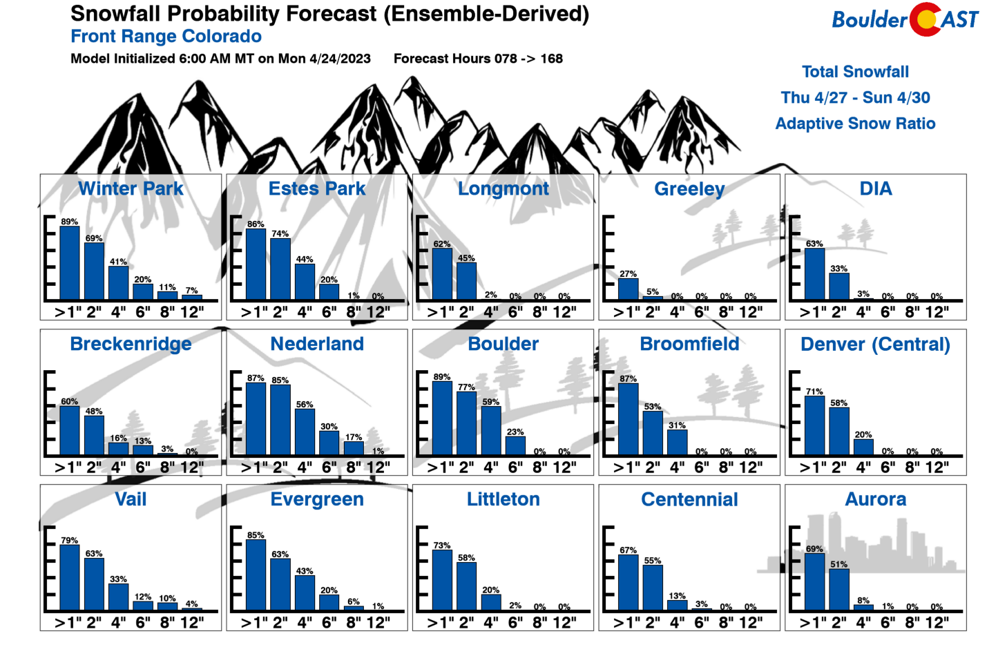
Just a heads up! Another quick-hitting storm will arrive Thursday night into Friday morning — one which will actually offer a better chance of accumulating snow for the entire Metro area as it will pack colder air. As our latest Snowfall Probability Charts show, the late-week storm should deliver 1 to 4″ of snow for the Metro area, with 3 to 7″ in the Foothills. More on that one to follow in the coming days.
That’s all for now. Depending on your elevation, enjoy the thunder, soaking rain, and/or heavy snow this evening!


Go Premium, get all the perks.
Daily Forecast Updates
Get our daily forecast discussion every morning delivered to your inbox.
All Our Model Data
Access to all our Colorado-centric high-resolution weather model graphics. Seriously — every one!
Ski & Hiking Forecasts
6-day forecasts for all the Colorado ski resorts, plus more than 120 hiking trails, including every 14er.
Smoke Forecasts
Wildfire smoke concentration predictions up to 72 hours into the future.
Exclusive Content
Weekend outlooks every Thursday, bonus storm updates, historical data and much more!
No Advertisements
Enjoy ad-free viewing on the entire site.
Get BoulderCAST updates delivered to your inbox:
Enjoy our content? Give it a share!


You must be logged in to post a comment.