
As our snow season begins to wind down across the Front Range, our Winter Storm Updates are arriving to your inbox less and less. However, an interesting setup knocking on the door will create a quick chance of banded snowfall Friday night with everyone poised to see some white stuff accumulate. Let’s discuss the latest on the approaching snow bands including their timing, travel impacts and ultimately how much snow will stick.

Go Premium, get all the perks.
Daily Forecast Updates
Get our daily forecast discussion every morning delivered to your inbox.
All Our Model Data
Access to all our Colorado-centric high-resolution weather model graphics. Seriously — every one!
Ski & Hiking Forecasts
6-day forecasts for all the Colorado ski resorts, plus more than 120 hiking trails, including every 14er.
Smoke Forecasts
Wildfire smoke concentration predictions up to 72 hours into the future.
Exclusive Content
Weekend outlooks every Thursday, bonus storm updates, historical data and much more!
No Advertisements
Enjoy ad-free viewing on the entire site.
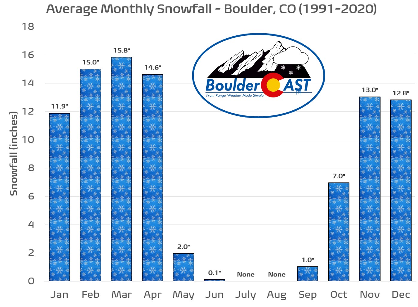
pril thus far has been a dry and relatively warm month across the Front Range. For example, Boulder is running about 1.1°F above normal and has reported only 0.75″ of precipitation month-to-date, well below the average amount of around 2″ we would expect through the first 21 days of the month. Snowfall has been lacking of late, too. After a strong showing for the first two-thirds of the season, snow has become increasingly hard to come by since about late February. Boulder’s season-to-date snowfall of 77.5″ is roughly 4″ below normal.

A bulk of the snow season is indeed already behind us. It’s hard to believe, but after April 20th, Boulder only receives about 3″ of additional snowfall in a typical year, though we all know late-season dumpings of soupy snow often happen here all the way through Memorial Day!
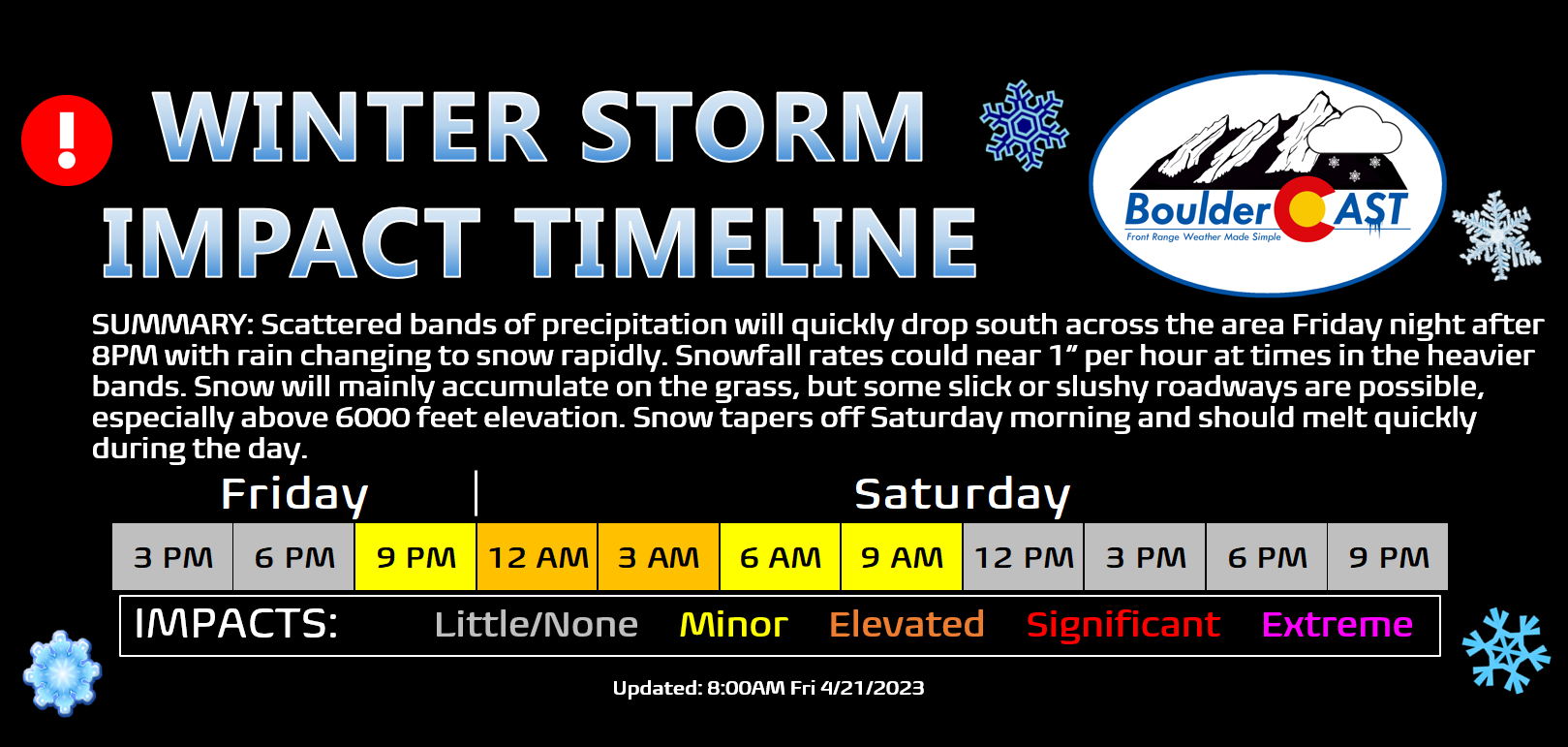
As luck would have it, those climatologically-promised three inches of snow could very well end up dumping later tonight as a quick-hitting cold front blasts into the Front Range after sunset Friday evening fueling a short but intense period of frontogenesis and upslope across northeast Colorado. This front will usher in a favorable setup for banded snowfall across the entire Denver Metro area, something that is shown nicely by the simulated radar animation below from the high-resolution HRRR model. Snow bands oriented from northwest-to-southeast will sag southward after 8PM into the Boulder-Denver area with snowfall rates approaching 1″ per hour in these bands.

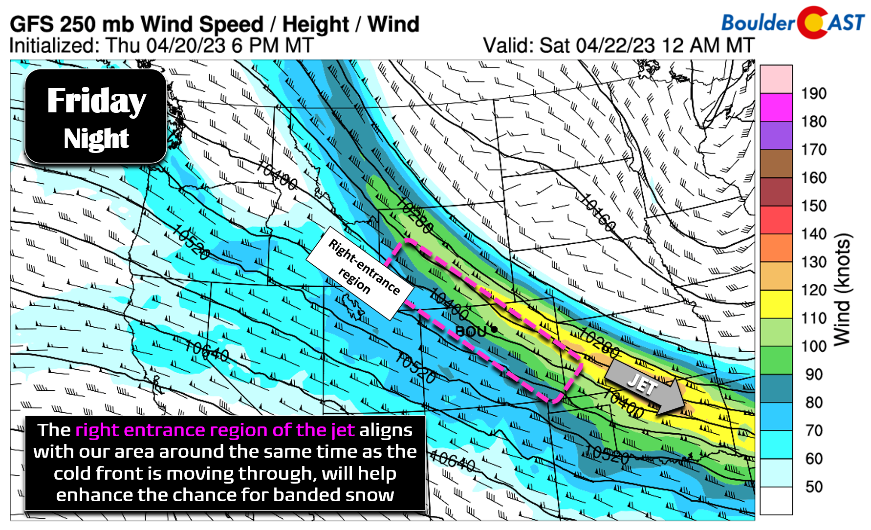
The threat of banded snowfall tonight is enhanced further by the orientation and positioning of the overhead jet stream. The entire Front Range will briefly land in the long and narrow right-entrance region of the jet — an area favorable for pockets of lift in the atmosphere. Everything we are seeing points to good potential for banded snowfall Friday night!
Forecast low-level winds and temperatures for midnight Friday night are shown below — juicy northeasterly upslope of 15 to 20 MPH will immediately follow the front.
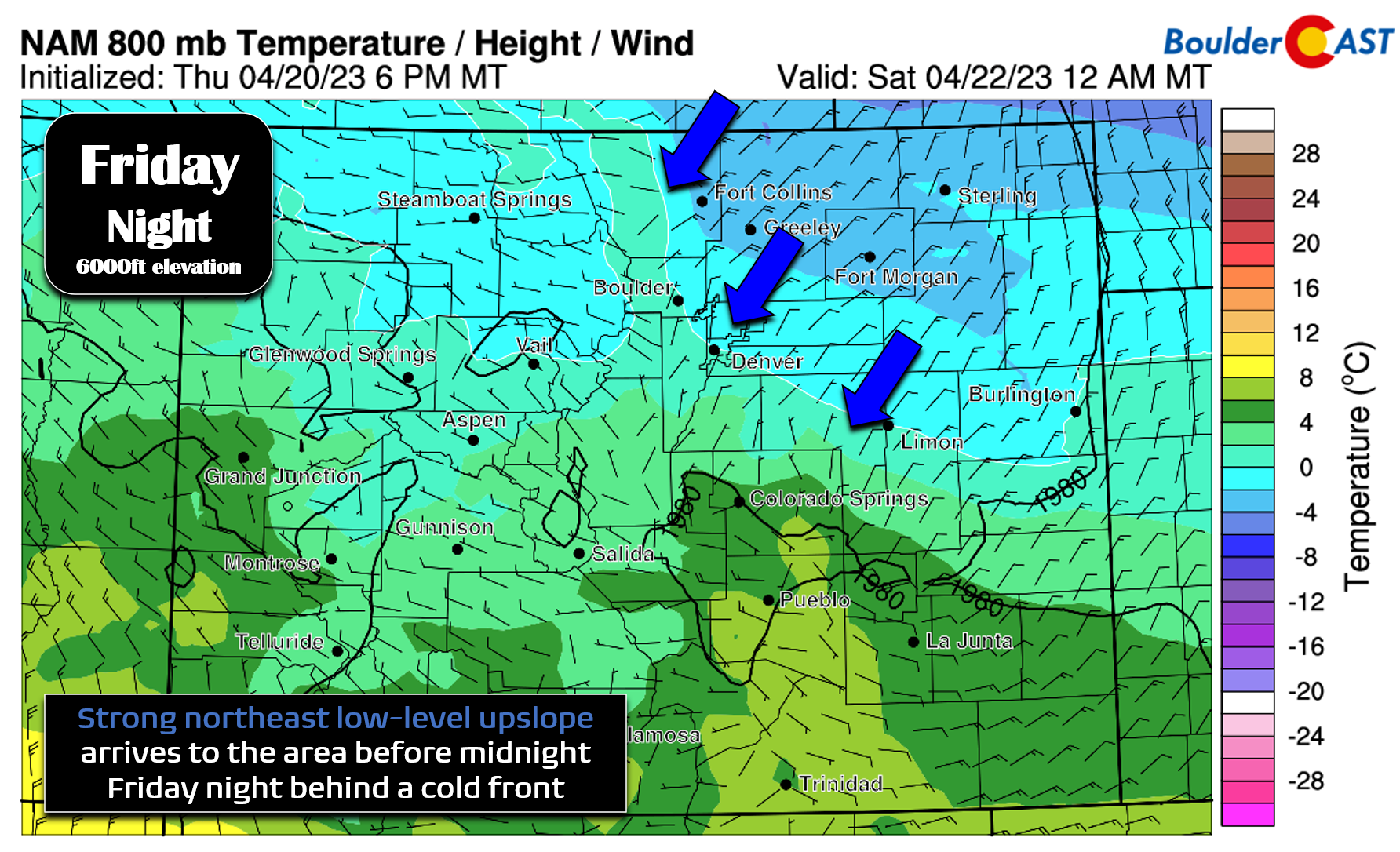
Post-front, upslope will be the name of the game heading through the rest of the night and into Saturday thanks to high pressure up in Wyoming. By early Saturday morning, low-level winds will have weakened but will be turned almost due easterly across our area — the most efficient direction for upslope in Boulder County. This should help to keep light snowfall going through most of Saturday morning in favored spots from Golden to Boulder to Fort Collins.

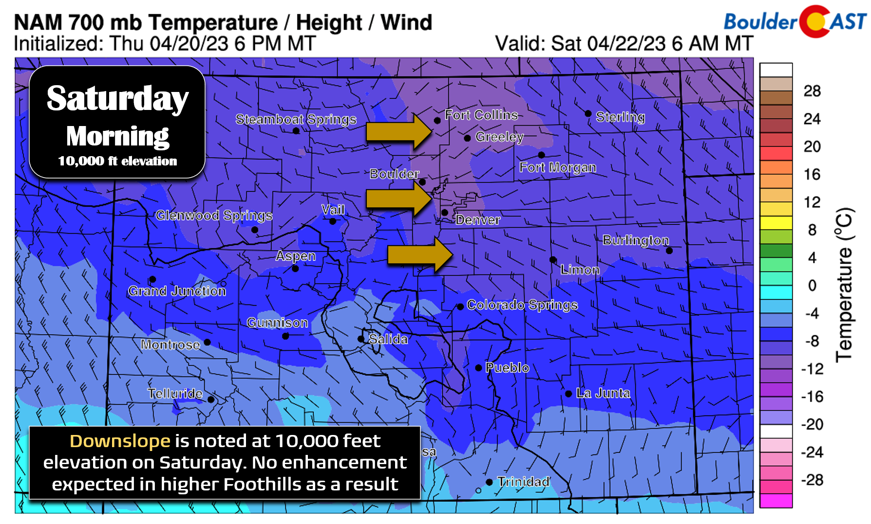
Sadly this is a rather weak system overall and the cold airmass is somewhat shallow. Looking higher up at just 10,000 feet elevation on Saturday morning, there is no trace of upslope at all! In fact, it’s a purely downslope regime here. This downslope will likely create an area of lower snowfall totals between the Continental Divide (which will see orographic snowfall from moist westerly flow aloft) and the lower Foothills (which will see the best low-level upslope from the east).
Friday will be mostly cloudy with continued cool temperatures — highs will be below normal in the low to middle 50s. As the front moves through this evening, there may be some rain at the onset of the precipitation bands on the Plains, but temperatures will quickly drop below freezing aided by the overnight timing — thus the change-over to snow will be swift for everyone! A combination of the colder temperatures and elevated snowfall rates should allow for snow to accumulate on the grass and even the roadways in spots. The highest probability of banded snowfall comes between 8PM and 4AM Friday night — this is when a bulk of the accumulation would occur. Snowfall should taper off Saturday morning for most areas before perhaps redeveloping slightly Saturday afternoon and evening aided by daytime instability. Little to no additional accumulation is expected beyond Saturday morning, except for maybe an inch or two in the higher Foothills.

Our snowfall forecast map for the event is shown below covering all snow through Saturday evening. This isn’t a huge winter event by any stretch of the imagination, but in general it should produce 1-3″ of snowfall for most of the area with slightly higher amounts in and near the Foothills. Due to the banded nature of the snow, we do expect a potentially wide range of totals over short distances, with areas where bands linger longer in it for the most snow.
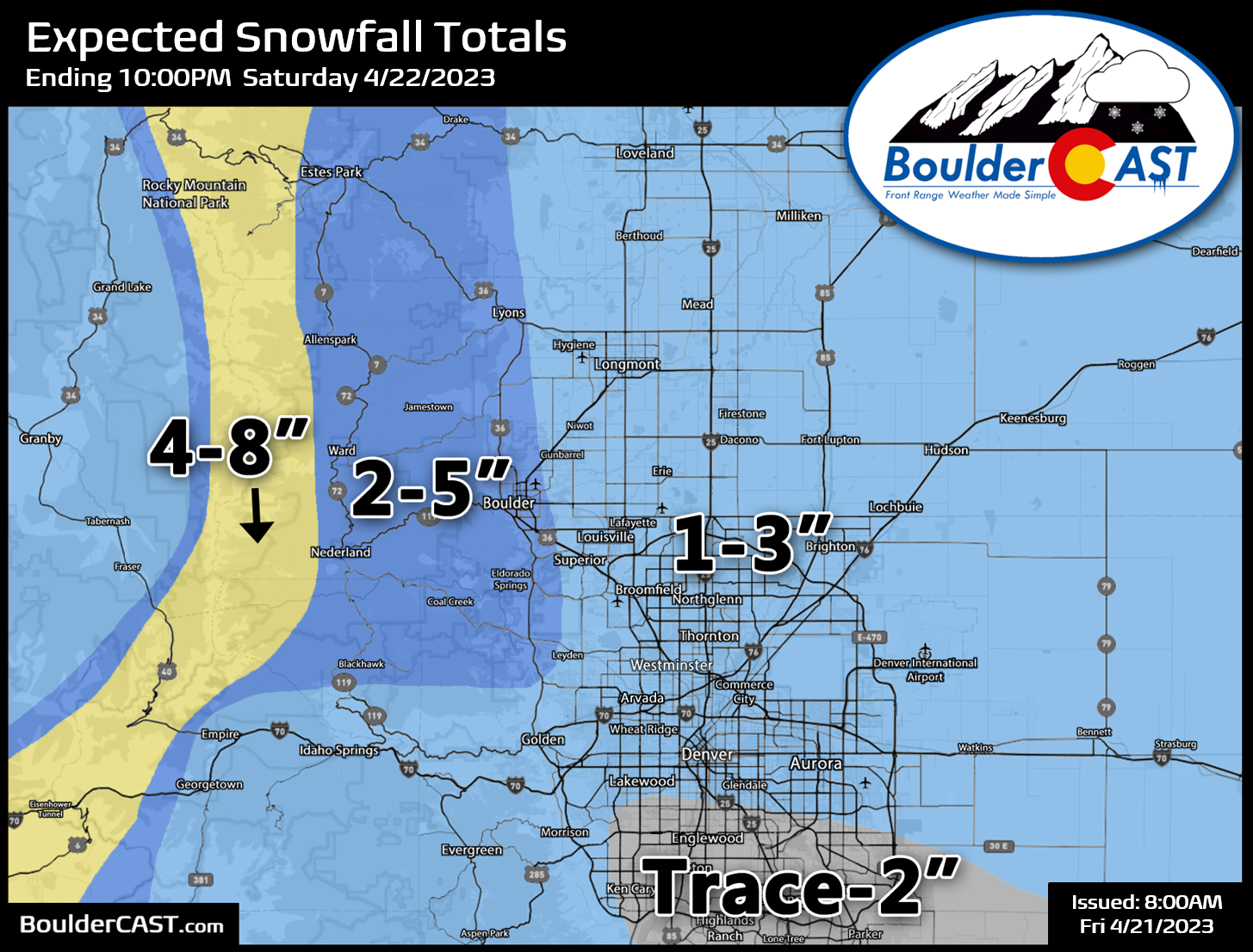
Impacts should be fairly limited with this event, though due to the threat of moderate to heavy snow at times during the middle of the overnight, some brief travel impacts should be expected, especially in the Mountains and Foothills above 6000 feet elevation. Snow-covered roads in the higher terrain will linger into early Saturday before snow melts off throughout the day.
It’s unfortunately been a challenging spring season for snowfall forecasting here in the Front Range, with Mother Nature often not cooperating with the model guidance so well. We’re cautiously optimistic that this banded snowfall setup knocking on our door will deliver the expected amounts across the Front Range tonight. We’ll have one final rundown of the latest model data posted later today for Premium members. Otherwise, enjoy the snow!

Get BoulderCAST updates delivered to your inbox:
Enjoy our content? Give it a share!


You must be logged in to post a comment.