The week starts off on the chilly side with rain/snow showers for our Monday thanks to a passing area of low pressure. Snowfall amounts will be rather limited by marginal temperatures, with the best chance for a few inches of accumulation being in the Foothills. A trend toward above normal temperatures will take over by mid to late week as an omega blocking pattern sets up over the central United States. We are watching the potential for not only fire weather concerns late in the week but also a rain/snow chance for the weekend as another strong storm system moves in. Let’s take a look!
This week’s highlights include:
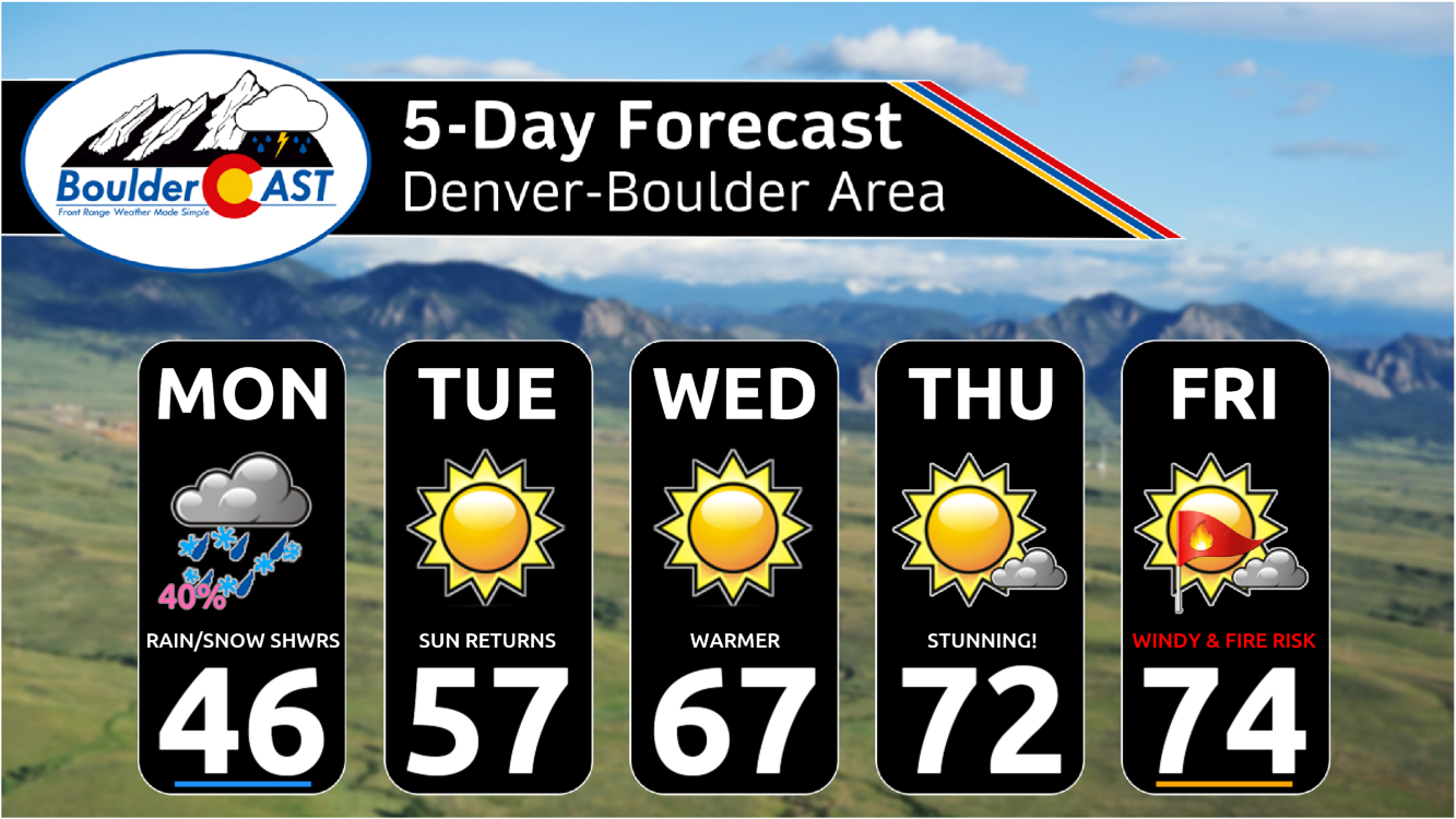
- Cold with rain/snow showers: We start the week on the cold side Monday with rain/snow showers around. Limited accumulation are expected for our Monday, with highest chances in the western burbs of Boulder/Foothills and southwest Denver near the Palmer Divide.
- Warming up: Ridging will start to develop as early as midweek, setting up a warming trend for the area. An omega block will be in-place Wednesday through Friday, with temperatures likely reaching the lower 70s in most locales.
- Late-week pattern shift: Our next storm system will approach Friday into the upcoming weekend. Fire weather concerns are increasing for Friday, along with another rain/snow chance for Friday night or Saturday.
DISCLAIMER: This weekly outlook forecast is created Monday morning and covers the entire upcoming week. Accuracy will decrease as the week progresses as this post is NOT updated. To receive daily updated forecasts from our team, among many other perks, subscribe to BoulderCAST Premium.

Go Premium, get all the perks.
Daily Forecast Updates
Get our daily forecast discussion every morning delivered to your inbox.
All Our Model Data
Access to all our Colorado-centric high-resolution weather model graphics. Seriously — every one!
Ski & Hiking Forecasts
6-day forecasts for all the Colorado ski resorts, plus more than 120 hiking trails, including every 14er.
Smoke Forecasts
Wildfire smoke concentration predictions up to 72 hours into the future.
Exclusive Content
Weekend outlooks every Thursday, bonus storm updates, historical data and much more!
No Advertisements
Enjoy ad-free viewing on the entire site.
Week starts out cold with rain/snow showers
Our week starts off chilly to cold as an area of low pressure has brought northeasterly upslope flow and cold air to the Front Range. This area of low pressure will reach Nebraska/Iowa by midday on Monday. As it continues to move to the northeast, it will drag down colder air by the late afternoon and evening. Highs Monday should top out in the 40s across the Metro area.
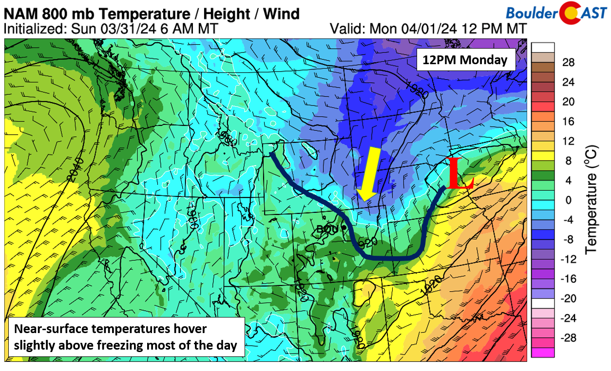
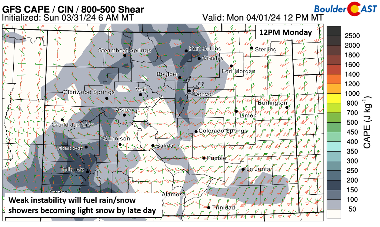
We have been watching the chance of rain/snow showers for Monday since last Thursday. The main forcing for rain/snow will be a combination of upslope flow and weak (300 J/kg or less) instability. A mid-level shortwave will track from New Mexico into the Oklahoma Panhandle and central Plains later Monday evening, but its track is too far south to provide additional upper-level forcing.
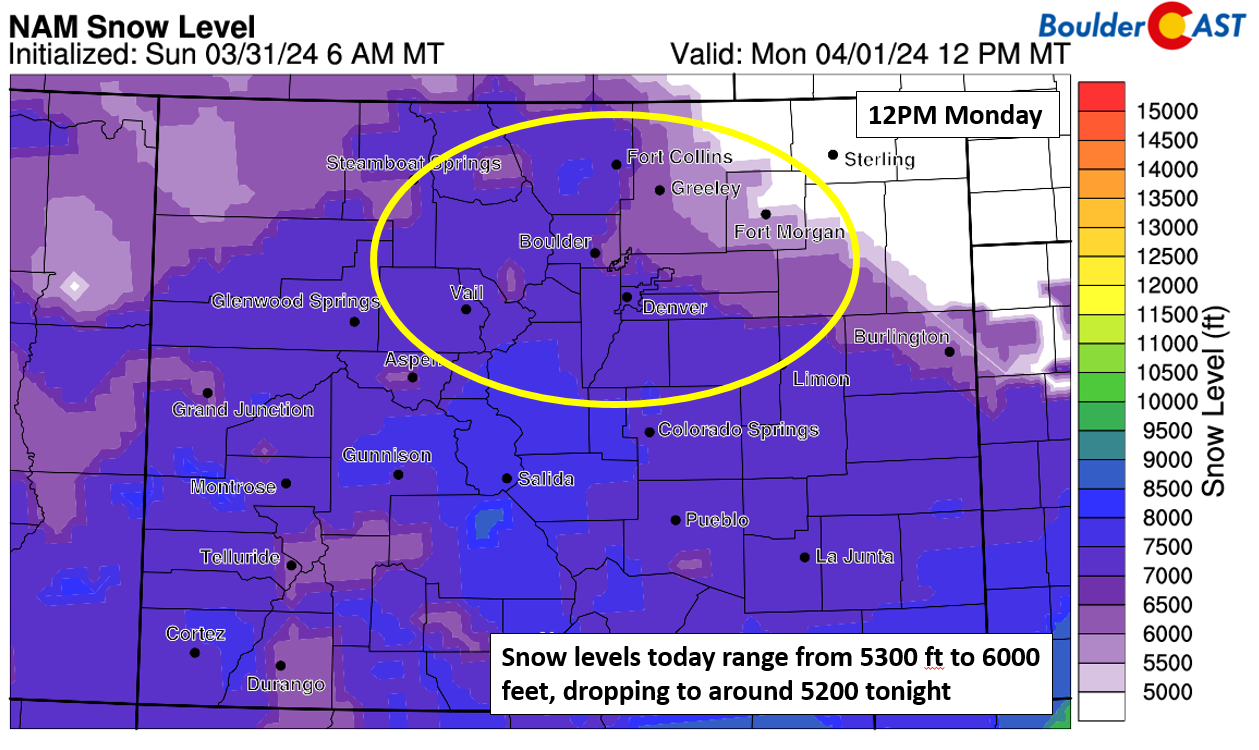
Snow levels Monday are expected to start out in the 5200 feet range near Greeley to around 7000 feet in Boulder/Denver. These snow levels are expected to lower to around 5300 feet or so by this evening.
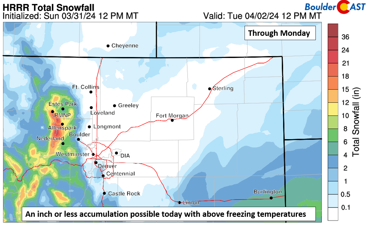
As instability develops and upslope flow strengthens, a mix of rain/snow should develop by mid to late morning and early afternoon over the Front Range. A transition to mostly snow showers should then take hold this evening, but precipitation will likely wane by the mid to late evening. With surface temperatures above freezing and precipitation mainly falling during the daylight hours, we are expecting only limited snow accumulation. The latest HRRR agrees with our thinking, showing maybe a slushy inch in Boulder, to a trace to 1/2″ in other parts of the Denver Metro area. A better chance of 2+ inches would be in the Foothills which could see up to 8″ by Monday night.
Waking up to a dusting of graupel accumulation! #cowx pic.twitter.com/9QVlZguugt
— BoulderCAST Weather 🏔️❄️ (@BoulderCAST) April 1, 2024
Warm the remainder of the week with fire danger increasing
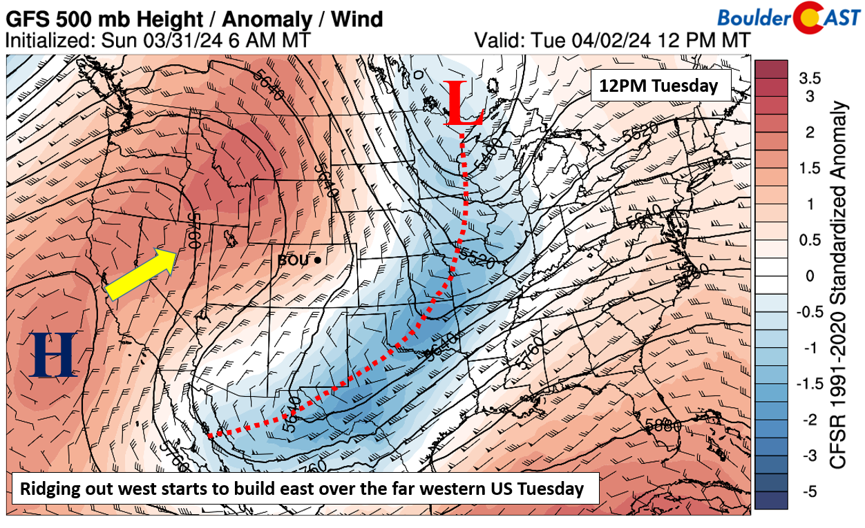
Come Tuesday, a much different weather pattern will take shape across the Rockies. The trough axis will slide east into the midsection of the country. Meanwhile, a ridge off California will push somewhat inland along the West Coast. That will spell out sunshine for our Tuesday and warming temperatures closer to normal in the upper 50s.
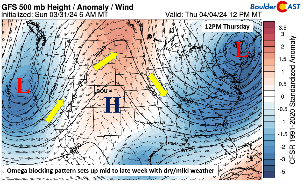
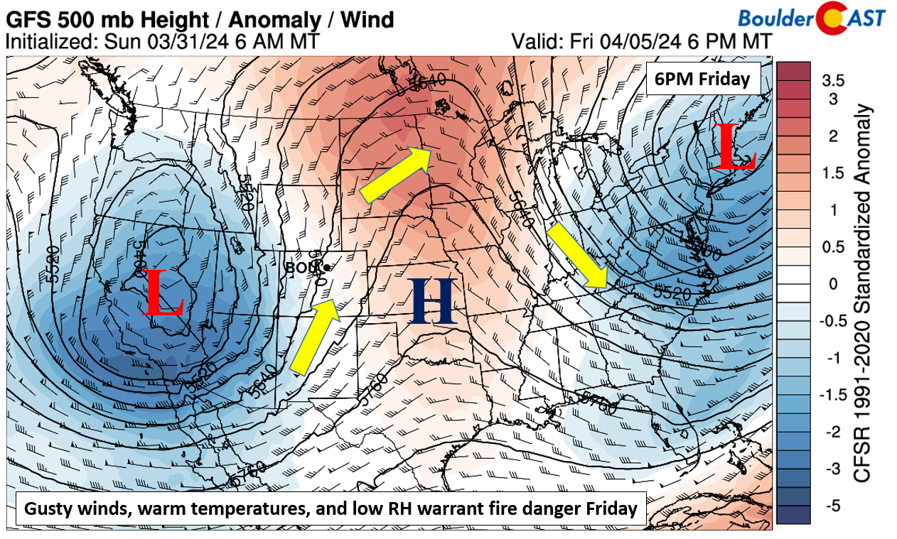
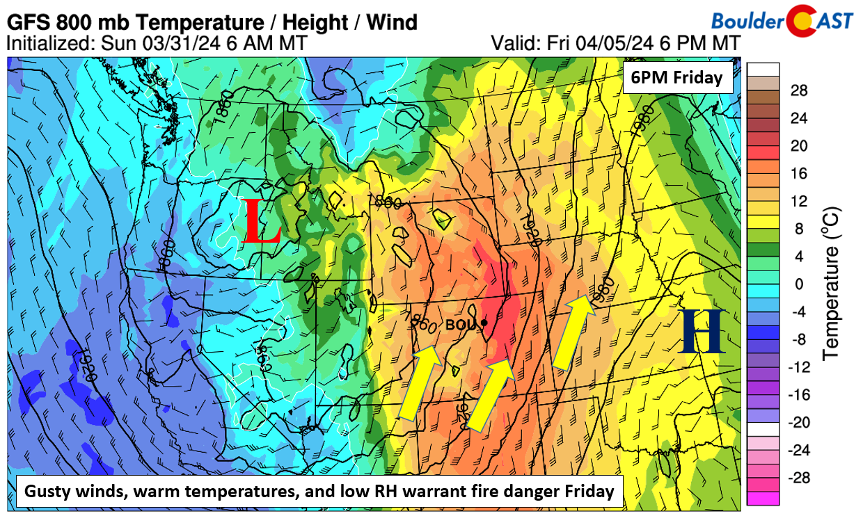
By mid to late in the week, the ridge over the west coast will move into the Intermountain-West to central Plains. An omega block will actually set up, with troughing on either side of the ridge. One trough will be off the West Coast and another in New Englad. We will continue our warm and dry pattern for Wednesday and Thursday with highs likely getting into the upper 60s to lower 70s in most locales.
There is pretty good model agreement that a late-week storm system will move onshore into Nevada by Friday evening. The Omega block will remain in place but shift eastward as the ridge is centered over eastern Kansas. A combination of gusty winds from the southwest, low humidity levels, and highs in the 70s will warrant fire danger concerns for the end of the week Friday.
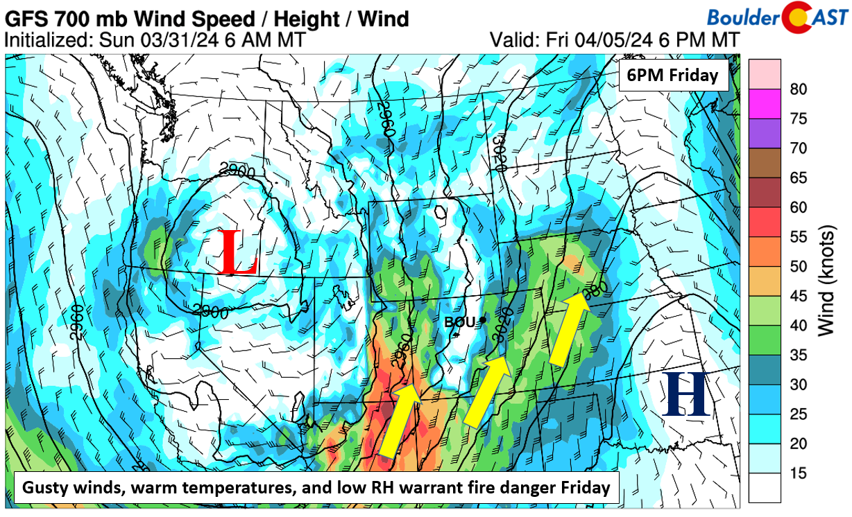
A potent southwest flow sets up at the surface on Friday, with gusts possibly above 30s MPH, especially along/east of Denver, as shown below.
At 5,000 feet up above the ground, these winds increase to about 40-45 MPH on Friday. While not shown, the ECMWF/GFS model fields of surface relative humidity at this time suggest sub-15% levels, well supportive of increased fire danger.
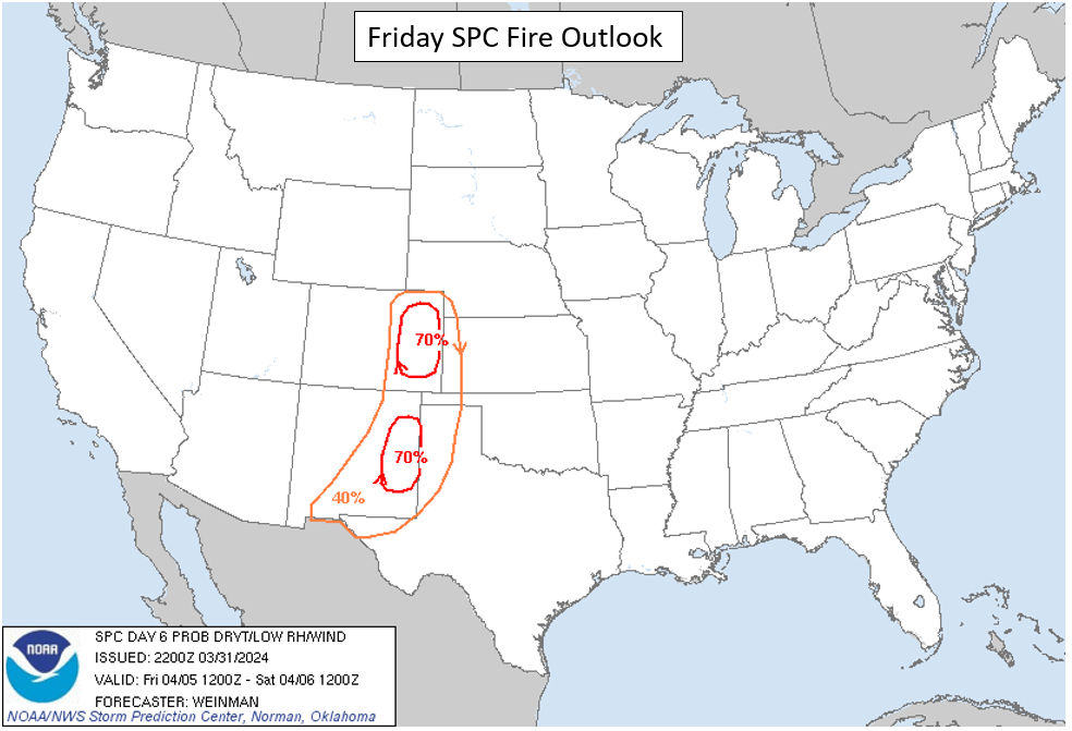
The Storm Prediction Center’s fire outlook for Friday shows these concerns, with a 70% region over eastern Colorado where a combination of warm temperatures, low RH, and gusty winds will coincide. This is something we will have to monitor as the week progresses.
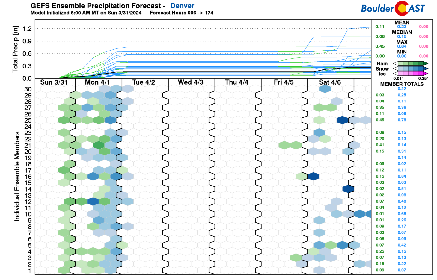
In addition to fire concerns, there is some potential that the aforementioned storm system could bring a rain/snow chance either late Friday night or Saturday as the system in Nevada tracks eastward. However, as shown in the GEFS precipitation plume forecast below, there is a lack of agreement, likely because the system takes a west-east track and this would favor more downslope than upslope.
Stay tuned for updates on the weekend storm as we go through the week and enjoy this (mostly) lovely first week of April!
Get BoulderCAST updates delivered to your inbox:
Forecast Specifics:
Monday: Mostly cloudy with rain/snow showers becoming mostly snow showers later in the day. Snow showers taper off by mid to late evening. An inch or less of slushy accumulation is possible across the low elevations, with 1-8″ in the Foothills. Highs in the upper 30s to middle 40s on the Plains with lower 30s in the Foothills.
Tuesday: Sunny and warmer with highs in the upper 50s in the Denver Metro area and middle 40s in the Foothills.
Wednesday: Sunny and mild with upper 60s to near 70 for the Plains and upper 50s in the Foothills.
Thursday: Partly to mostly sunny and warm. Highs in the lower 70s for the Plains and lower 60s in the Foothills.
Friday: Partly cloudy, breezy, and warm. Elevated fire concerns may be warranted. Highs in the lower to middle 70s on the Plains and lower 60s in the Foothills. There could be a low-end chance of rain or snow overnight into Saturday.
DISCLAIMER: This weekly outlook forecast is created Monday morning and covers the entire upcoming week. Accuracy will decrease as the week progresses as this post is NOT updated. To receive daily updated forecasts from our team, among many other perks, subscribe to BoulderCAST Premium.
Go Premium, get all the perks.
Daily Forecast Updates
Get our daily forecast discussion every morning delivered to your inbox.
All Our Model Data
Access to all our Colorado-centric high-resolution weather model graphics. Seriously — every one!
Ski & Hiking Forecasts
6-day forecasts for all the Colorado ski resorts, plus more than 120 hiking trails, including every 14er.
Smoke Forecasts
Wildfire smoke concentration predictions up to 72 hours into the future.
Exclusive Content
Weekend outlooks every Thursday, bonus storm updates, historical data and much more!
No Advertisements
Enjoy ad-free viewing on the entire site.
Enjoy our content? Give it a share!


You must be logged in to post a comment.