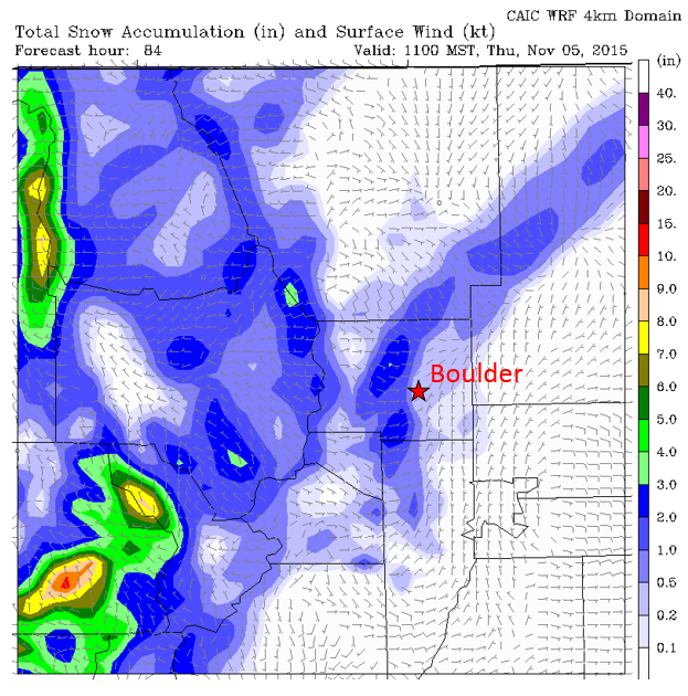
We couldn’t have asked for a better Halloween weekend, with partly sunny skies skies and temperatures in the upper 60’s and low 70’s. We review October’s weather, and look ahead to an unsettled weather pattern for the week ahead. We may have dodged a bullet last week with regards to the season’s first snow; however, it doesn’t appear we will be quite as fortunate this go-round!
With October now behind us, let’s take a look a quick look back. The month started very warm and dry, but cooled down towards the latter portion. The average high was 69 degrees for the month, about 4 degrees above normal. Much of the western two-thirds of the United States was in the same boat, with the largest anomalies occupying the spine of the Rockies.
Boulder ended the month with 2.02″ of rain, about 0.5″ above average. Nearly 90% of this amount fell during the event on October 21-22. No snowflakes were observed on the Plains, but the Foothills above ~7,500 feet had their first snows during the month. The Front Range made out quite well in October actually, with above normal precipitation across the board.

AHPS total precipitation for the month of October, shown as a percentage of normal. The Front Range received twice the normal amount for the most part.
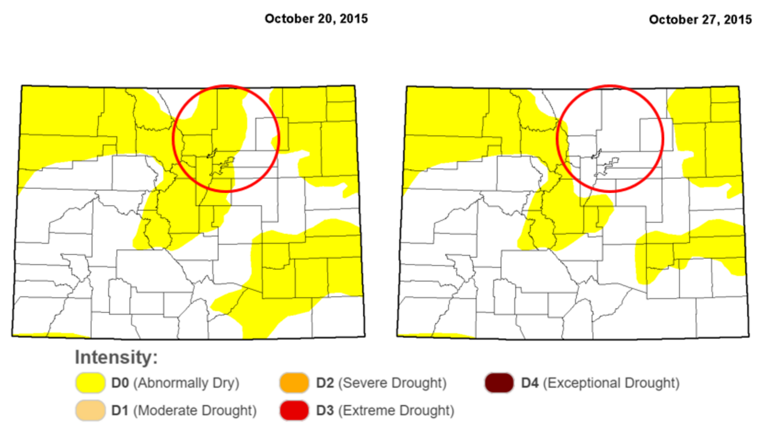
This has helped to alleviate the very dry pattern across our region. Notice the change in “Abnormally Dry” conditions across the Front Range between October 20th (left) and 27th (right).
Boulder now sits at 23.98″ of year-to-date precipitation for 2015, a hefty 6 inches more than normal. The recent rain event definitely helped to get us back on track!
Looking ahead into November, the Climate Prediction Center is projecting “Equal Chances” for temperature for most of Colorado, while predicting a 40% chance of above normal precipitation.
Looking to the week ahead, temperatures will begin quite warm, but an upper-level system will swoop into Colorado by Wednesday, bringing with it a drastic change in our weather. Shown below is the 500 mb vorticity map, valid Monday morning.
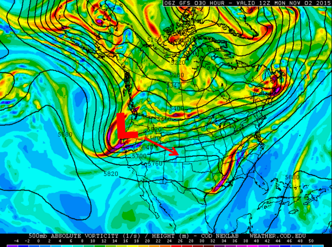
GFS 500 mb vorticity map for North America, valid Monday morning. The location of this week’s trough is off the coast of Oregon.
You can see the trough is located just offshore of Oregon. Colorado is located ahead of this system, under slight ridging, with west-southwesterly upper-level flow. This will breed warm, downslope conditions for Boulder County. Expect mostly sunny skies and temperatures in the low 70’s. Winds in the Mountains will be gusty at times, as high as 50 mph.
Tuesday will be similar to Monday. The trough edges closer, into Nevada and western Utah. Expect more clouds, mostly mid and upper level ones, during the day. This will keep temperatures a little cooler, but still well above normal. Mid to upper 60’s for the Plains are a safe bet.
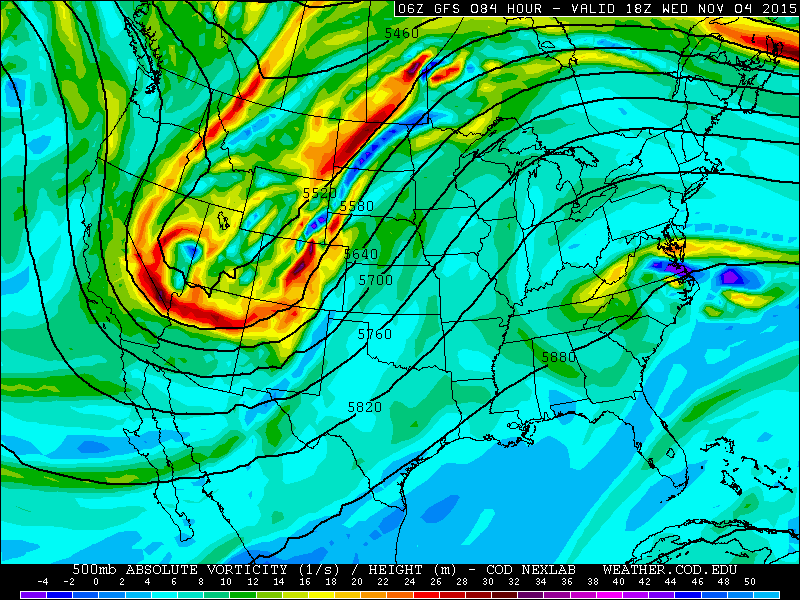
Wednesday sees the influence of the trough finally reaching northeast Colorado. This is where things get a little interesting.
The cold front associated with the trough looks to arrive for the Plains sometime Wednesday afternoon. The boundary is quite evident below, with a steep surface temperature gradient across NE Colorado (near 70 by Kansas border, but 30’s near the Wyoming border).
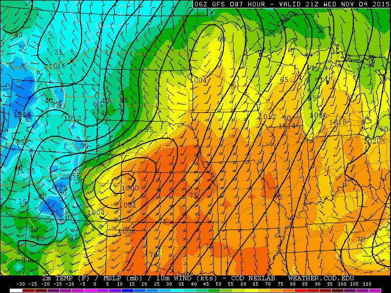
Forecast surface temperature, winds, and sea-level pressure valid at 3pm Wednesday. Notice the shard gradient in temperatures associated with the front, and the developing surface low in eastern Colorado.
Behind the front, northeastly flow will produce extensive cloud cover and a few showers for the Plains. Cold air advection, clouds, and precipitation will see high temperatures fall by 15 to 20 degrees from Tuesday to Wednesday. Highs will top out somewhere in the 50’s. Initially, temperatures will only be cold enough to support snow in the higher Foothills. However, snow levels will be dropping through the evening, especially overnight into Thursday.
Late Wednesday, a surface low will develop on the Plains, with some uncertainty to where exactly this will be. The Euro and Canadian have it in SE Colorado, while the GFS and NAM have it in NE Colorado. Neither of these positions are all that favorable for producing much precipitation for Boulder County. However, the current model spread indicates uncertainty, and the track could become more favorable for our region. This time, temperatures will probably be cold enough for at least a mix of rain/snow all the way down onto the Plains, but with limited moisture, marginal cold air, and the fast-moving nature of the system, accumulations will be minimal. The most favorable location for precipitation will probably be confined to the CO/WY border, and in the mountains of western Colorado. For now, expect some light rain on Wednesday afternoon, slowly changing to light snow showers into early Thursday morning for everyone. Expect less than one inch of snow accumulation, if any for the Plains. The Foothills may pick up a couple of inches.
After about 6 am Thursday morning, the trough axis pushes through and flow becomes westerly. This should curb the precipitation for the lower elevations rapidly.
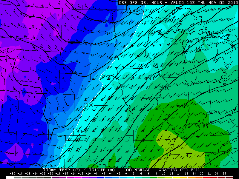
GFS 700mb heights, temperatures, and winds, valid at 11am on Thursday. The trough axis has moved through, bringing downslope conditions to our area.
Thursday will see the cold air mass entrench itself across the area. Skies will remain mostly cloudy, but things should dry out after noon, except for the Mountains near the Divide, where northwesterly flow will produce continued snow showers. Temperatures will remain in the 40’s for the Plains and Foothills. The Canadian model moves the trough through a bit slower, so we will keep a slight chance of showers in the forecast through the day.
Similar conditions will be in place for Friday. We suspect that morning temperatures may warrant northeast Colorado’s first Freeze Warning of the season. We will probably dip into the upper 20’s, with even colder temperatures in the favored low-lying areas, or if there are more breaks in the cloud cover. Another cold front moves into the area Friday late morning into the afternoon. It has very limited moisture and is fairly weak. We don’t expect much chance for precipitation at this point. It will only help to keep our temperatures in the 40’s once again.
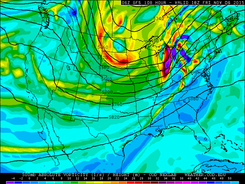
GFS 500 mb vorticity map, valid at noon Friday. You can pick up the weak energy moving thru Colorado, visible as a yellow streak of vorticity.
We will be sure to keep you posted if anything in the forecast changes to indicate the potential for more snowfall on Wednesday night. With the winter season rapidly approaching, now would be a great time to follow us on Twitter or Facebook for frequent storm/weather updates and to subscribe to the site’s email list (enter your email in the sidebar widget to right)!
The Forecast:
Monday: Mostly sunny skies and very warm. Highs in the low 70’s across the Plains, with 60’s in the Foothills.
Tuesday: Mostly sunny and warm. Highs near 70 on the Plains, with mid 60’s in the Foothills.
Wednesday: Some sun early, with clouds increasing through the day. Isolated rain showers in the evening, becoming more numerous through the evening, with the likelihood of snow mixing in after midnight on the Plains and a little earlier in the Foothills. Afternoon highs in the upper 50’s for the Plains, with low 50’s in the Foothills.
Thursday: Cloudy with scattered light rain/snow showers in the morning. Little to no accumulation expected for the Plains, with up to 3″ in the Foothills. Highs topping out in the mid 40’s for the Plains, with upper 30’s in the Foothills.
Friday: Mostly cloudy with isolated showers possible in the afternoon. Temperatures in the upper 40’s on the Plains, with low 40’s in the Foothills.
Extended Outlook:
After the weak system on Friday, a ridge builds back across the region, ushering in the return of sunshine and warm (er) temperatures for the weekend!
Source
Mon
Tue
Wed
Thu
Fri


BoulderCAST
72
70
57
44
47


NWS
69
68
51
45
46


AccuWeather
72
70
58
45
44


The Weather Channel
69
70
55
45
46
Last week’s recap:
Here are the results of last week’s forecast. First, the forecasts and observations:
Last week was a tricky forecast. There were a few weak cold fronts to deal with, but overall, similar temperatures each day as we were in between weather systems for the most part. Forecasts were not warm enough ahead of the front that passed on Wednesday (10/28), but too warm behind the front on Thursday and Friday.
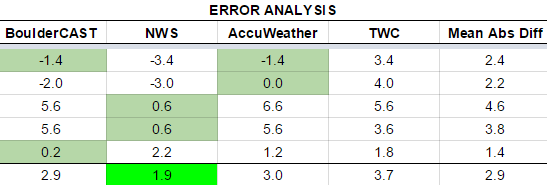
Now the error analysis. Shown is the amount of degrees (in Fahrenheit) that each source was off from the mean observed temperature for Boulder. Positive values indicate the forecast was warmer than what actually occurred, while negative values arise from a forecast that was cooler than what was observed.
The worst forecast for the week ended up being Wednesday, with nearly 5 degrees of error across the board. Cloud cover and some rain showers persisted, keeping us a little cooler than we expected. Only the NWS really nailed the cool down on Wednesday and Thursday.
The bottom row of the error table shows the weekly mean error for each weather outlet, a good measure for who was the best and more consistent “forecaster” for the week. The NWS takes first place this week, the first time in a long while, with just 1.9 degrees of error. BoulderCAST came in second, with 2.9 degrees of error, having the best forecast on both Monday and Friday. The Weather Channel brings up the rear.






You must be logged in to post a comment.