
After an extended period of meteorological tranquility, unsettled weather returns this week as a couple of systems are projected to impact the region. We discuss warm temperatures, windy conditions, and a late-week spring storm that bares watching for widespread rain and snow. Read on for all the details in our weekly outlook.
Pleasantly warm early in the week
The week begins with the storm track in the same location it has been for about two weeks now…just to our north.
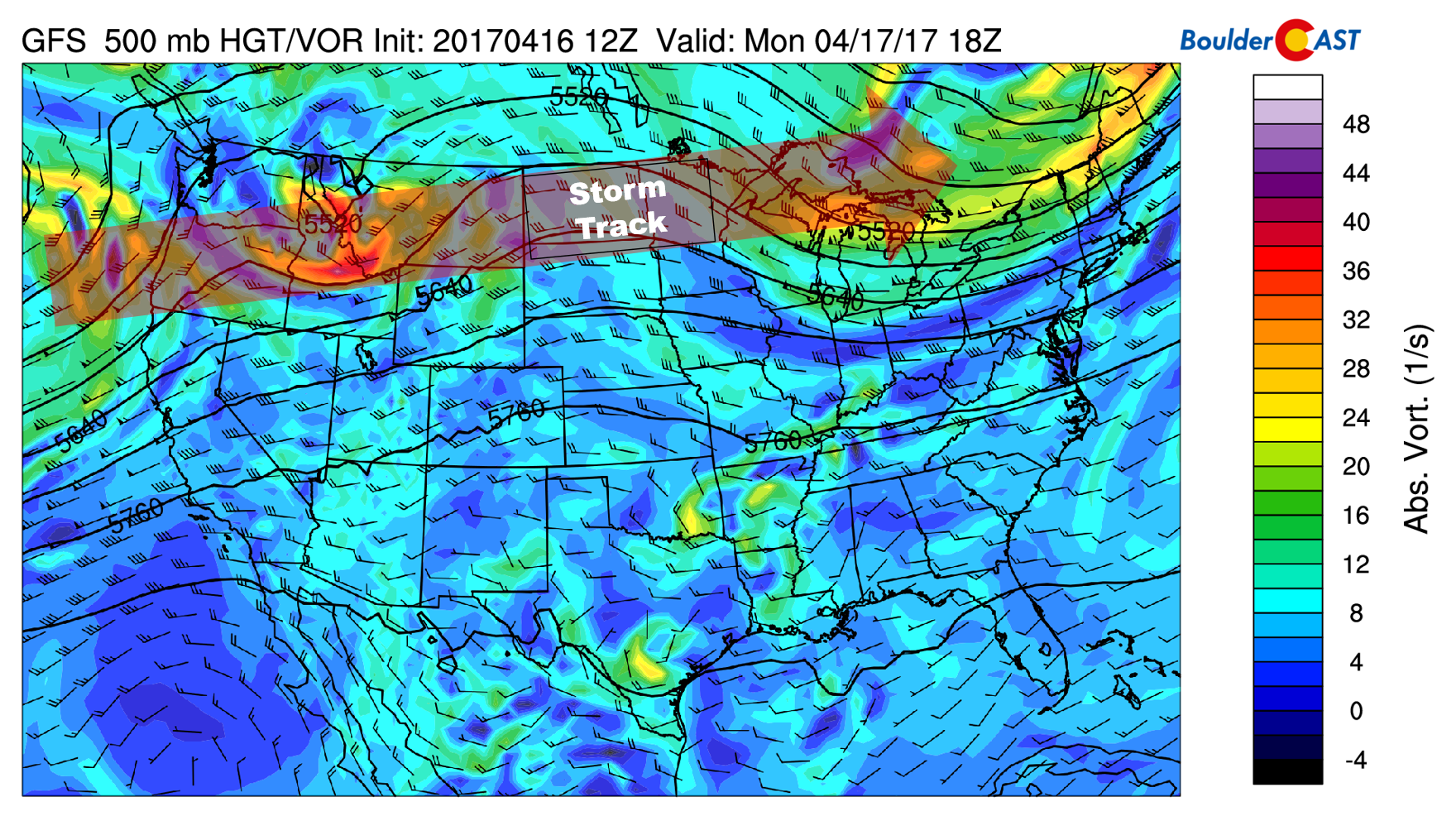
GFs 500 mb vorticity map for Monday afternoon. The storm track sits well to our north in Montana right now.
Southwesterly flow and ridging will prevail across Colorado into Wednesday. As a result, we’re expecting calm and warm conditions across the region for the first half of the week. Monday and Tuesday will see high temperatures in the mid to upper 70’s. There is a lot of mid and upper-level moisture embedded in the flow, so there will be a mix of clouds and sun both days. We’re optimistic that it won’t be mostly clouds…
Storm track slides south
By Wednesday, the storm track will move further south, bringing a weak system across southern Wyoming during the afternoon (see below).
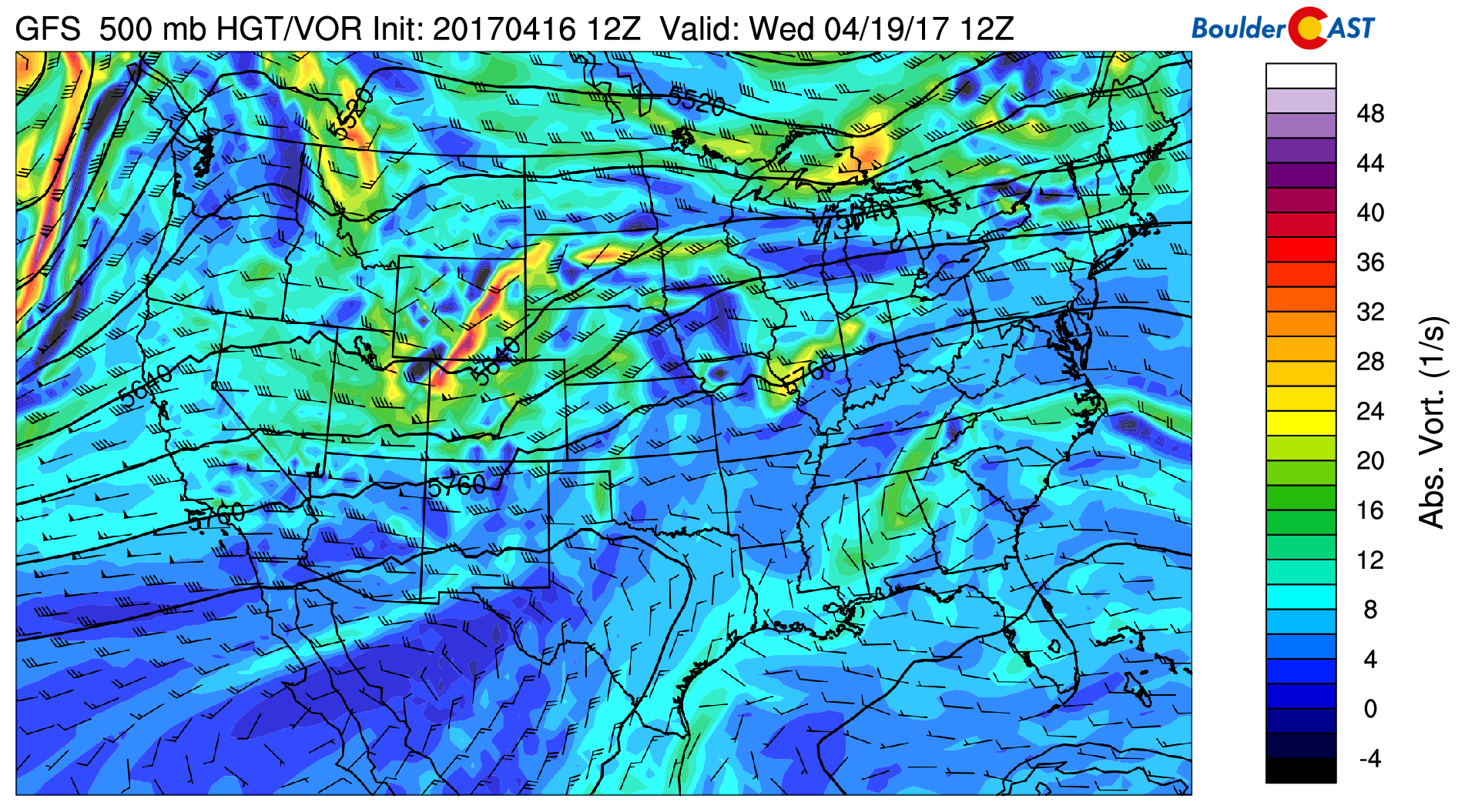
GFS 500 mb vorticity map for Wednesday morning showing the weak system moving through Wyoming and extreme northern Colorado.
Unfortunately, it looks like all of the moisture for this storm will remain north of the Colorado-Wyoming border or west of the Divide. Models show a surface low developing somewhere near or slightly north of Denver. This positioning will facilitate downslope across our region and very low if any chance of precipitation. A cold front will move through Wednesday morning or afternoon from the northwest, with breezy conditions on the backside. Gusts in excess of 30 mph will be possible.
The 800 mb map below for Wednesday evening shows the northwesterly downslope, as well as a cooler airmass across northeast Colorado. Highs Wednesday will only be in the mid to upper 60’s.
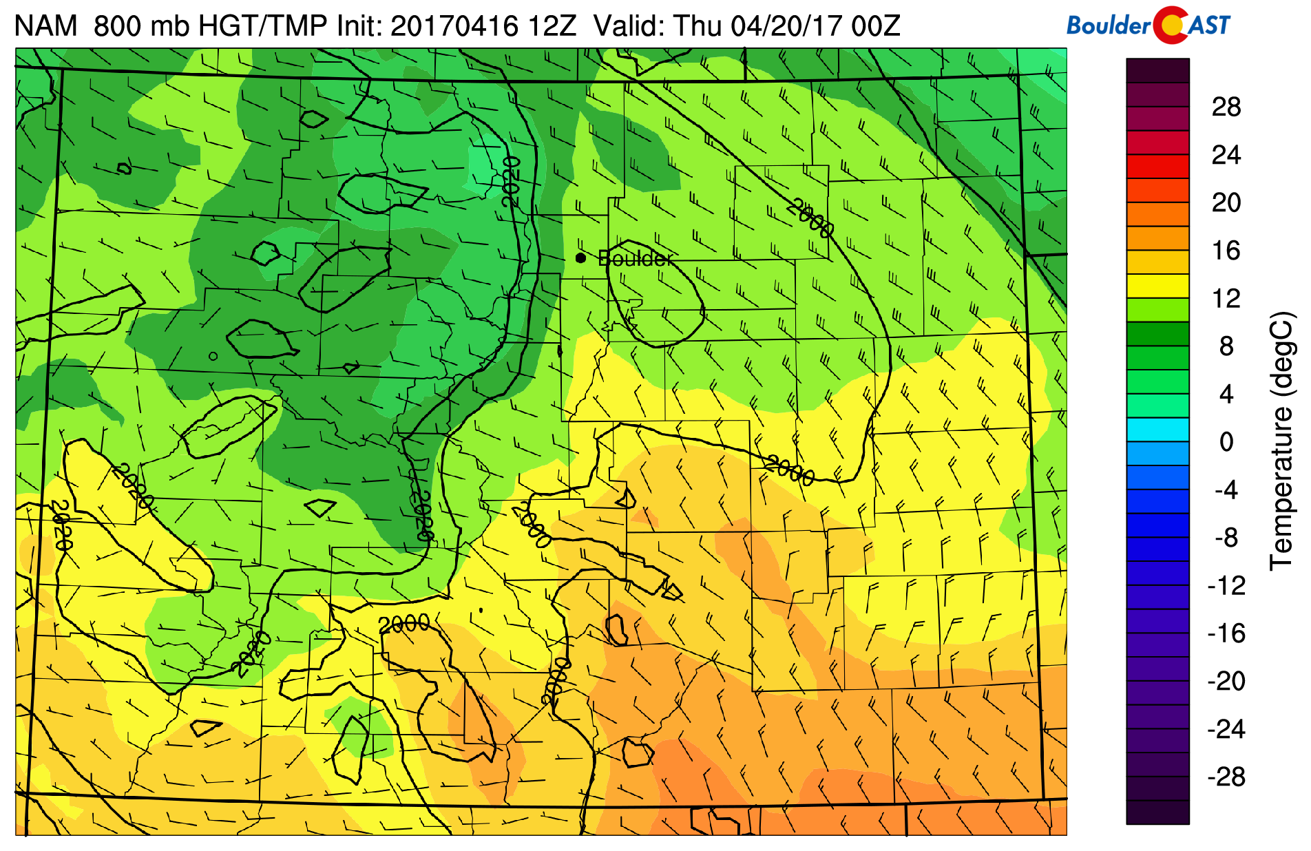
GFS 800 mb temperature and wind map for Wednesday.
Unsettled weather returns late-week
The wildcard for the week ahead lies with a storm that will impact our region Thursday afternoon into Friday. The models agree that a large trough will come ashore in the Pacific Northwest Wednesday, sliding across Utah and into Colorado by Thursday night.
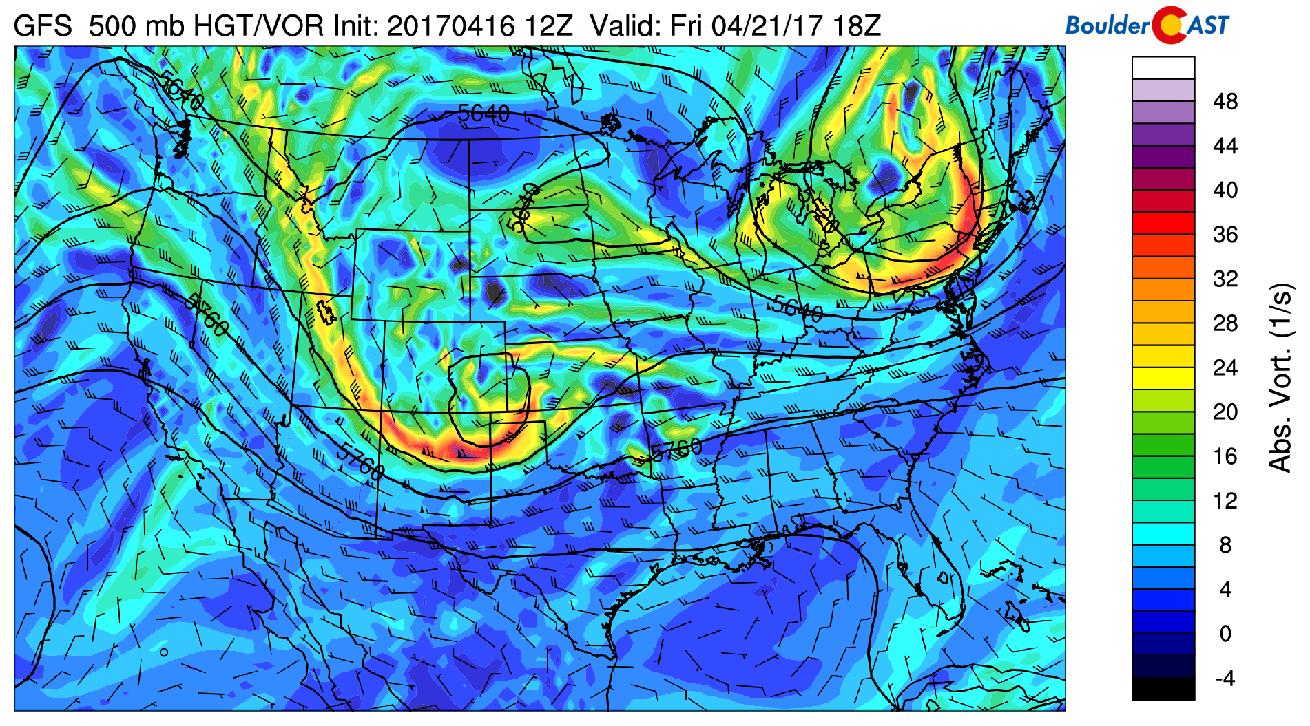
GFS 500 mb vorticity map for Friday afternoon. A closed-low may form across southeastern Colorado, a favorable spot to bring upslope to our region.
There is good indication that a closed-low could form somewhere in eastern Colorado. This would mean a decent upslope event for our region, with temperatures cold enough to produce snow in the Foothills, and maybe, just maybe, the Plains as well (probably not). We still think the storm looks a little too disorganized at 500 mb to get overly enthusiastic as of now (i.e. formation of the closed-low is questionable). It’s still four days away, so of course we can’t provide complete details yet. Nonetheless, we are seeing fairly good consistency between the GFS, European, and Canadian models. Here are a few general statements for now…
- Chances of precipitation increase Thursday afternoon and stick around into Friday evening before the upper-low heads east
- 0.5″ to 1.5″ of liquid precipitation are indicated. The latest GFS forecast precipitation for the event is below. Definitely some good moisture possible for the Front Range.
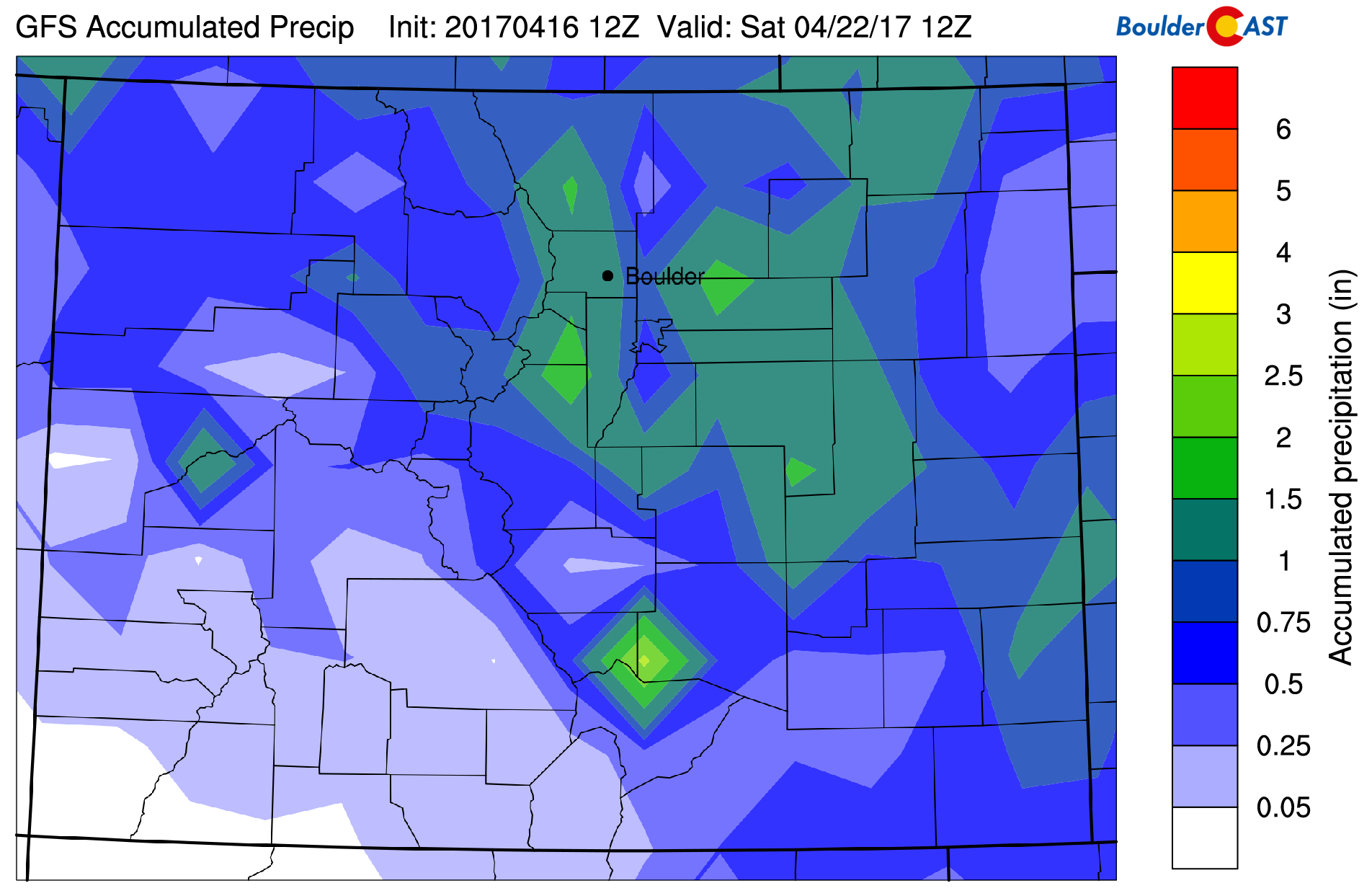
GFS precipitation forecast for the Thursday-Friday storm. ~1″ of liquid precipitation may be possible. Still to early to say for sure, though.
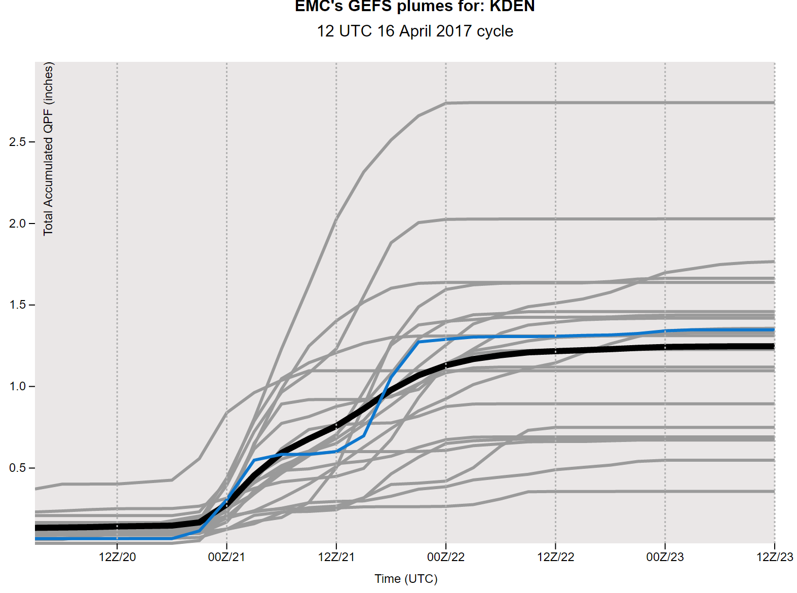
- The GFS ensemble forecast plumes for precipitation for the event are shown below. ~70% of the ensemble members predict 1.0″ or more of liquid in Denver. This graph also speaks to the potential long duration of the event…lasting about 36 hours from Thursday afternoon into Friday night.
- Snow levels begin high Thursday morning, near 10,000 feet or so, but fall as cooler air works its way in Thursday night and through the day Friday. Snow levels will be at their lowest Friday evening, likely down to around 6,000 to 7,000 feet. Significant accumulating snow is most likely above 8,000 feet. Most indication is for the Plains/Denver Metro to remain all rain. Slightly colder temperatures predicted by the Euro model (which could support snow) will keep us watching these temperatures over the next few days. If there will be any snow down low, we’d expect it to fall at the tail-end of the storm, during the second half of Friday.
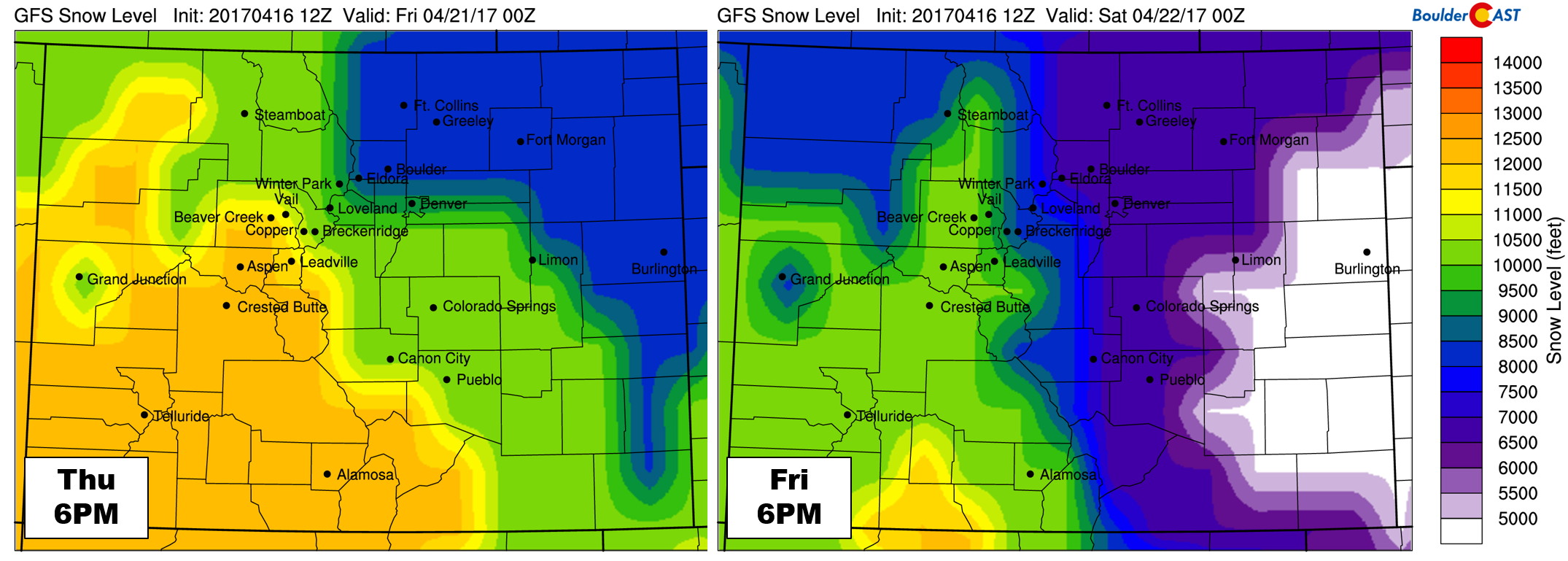
GFS-derived snow level forecast maps for Thursday evening (left) and Friday evening (right).
We’ll probably provide an update or two for the approaching system later in the week. It’s only mid April, we’re still not out of the woods for snow yet!
Forecast Specifics:
Monday: Partly to mostly cloudy and warm. Highs in the mid 70’s for the Plains and in the low 60’s in the Foothills.
Tuesday: Very warm with partly cloudy skies. Temperatures will rise into the upper 70’s across the Plains and into the mid 60’s in the Foothills.
Wednesday: Mostly sunny, cooler, and breezy with northwest winds gusting up to 30 mph. Highs in the mid to upper 60’s for the Plains and low 50’s in the Foothills.
Thursday: Morning sunshine will give way to increasing clouds during the day. Look for a few rain showers during the afternoon and evening. Snow levels will begin high, near 10,000 feet, but will fall Thursday evening and night towards 7,000 feet. Temperatures will peak in the upper 50’s across the Plains, with mid 40’s in the Foothills.
Friday: Overcast and dreary with scattered rain showers through much of the day, with snow in the Foothills above 7,000 feet. Significant snow accumulation may be possible for the higher Foothills. High temperatures Friday will be in the low 40’s across the Plains and near 30 in the Foothills.
High Country / Ski Resorts: We’re forecasting warm and dry weather Monday and Tuesday. Then, expect a few inches snow for the higher peaks about 10,000 feet in northwest Colorado Wednesday (near Steamboat), but little elsewhere. Snow chances increase Thursday afternoon into Friday night for most of the resorts. The track of the late-week storm is not favorable for too much snow in the Mountains west of the Divide, but we’d still expect 3-7″ or so for a storm like this. Saturday and Sunday will be quiet in the Mountains.
Weekend: Still a good deal of uncertainty surrounding the late-week system which could linger into Saturday. For now, we’ll go with a slight chance of rain and higher elevation snow showers Saturday with above normal temperatures and sunnier conditions returning for Sunday. Ensemble forecasts suggests troughing will be present across the West next week. At a high level, this should translate to an active pattern next week.
Mon
Tue
Wed
Thu
Fri


Temperature
75
79
67
58
42


Precip Chc (Plains)
0%
0%
0%
30%(pm)
50%


You must be logged in to post a comment.