For several days now we have anxiously been looking forward to a big cut-off pressure system forecasted to impact the southern Rockies on Monday. While we’re confident that heavy snow will indeed dump on eastern Colorado, we unfortunately don’t believe that will be across the Front Range. Let’s take a look at the evolving forecast and why this storm will most likely be a swing and a miss for the Denver area.
At a Glance:
- A major cut-off spring low pressure system will develop in eastern New Mexico on Monday
- Models are in good agreement that the storm will track too far south to produce any major impacts in the Front Range
- Strong northerly flow will be present most of the time in our area which only favors the Palmer Divide for upslope snow
- After a warm weekend, things turn colder and blustery on Monday with rain changing to snow in the pre-dawn hours for us
- Potential accumulations of less than 3″ in Denver and Boulder, with higher totals possible in the Foothills and Palmer Divide
- Cooler and unsettled weather sticks around through midweek with very little or no additional snow accumulation expected
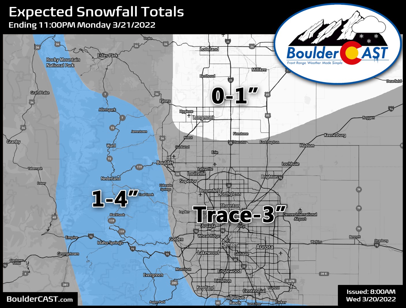
UPDATE (Sunday March 20, 2022 8AM): Added snowfall forecast map and timing breakdown.
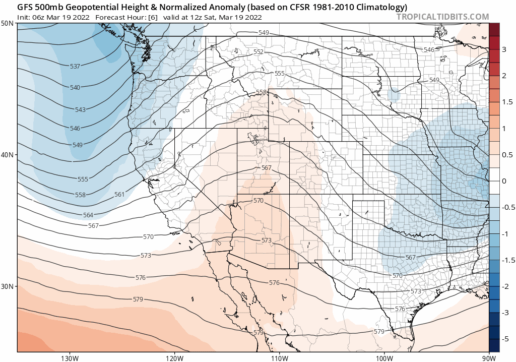
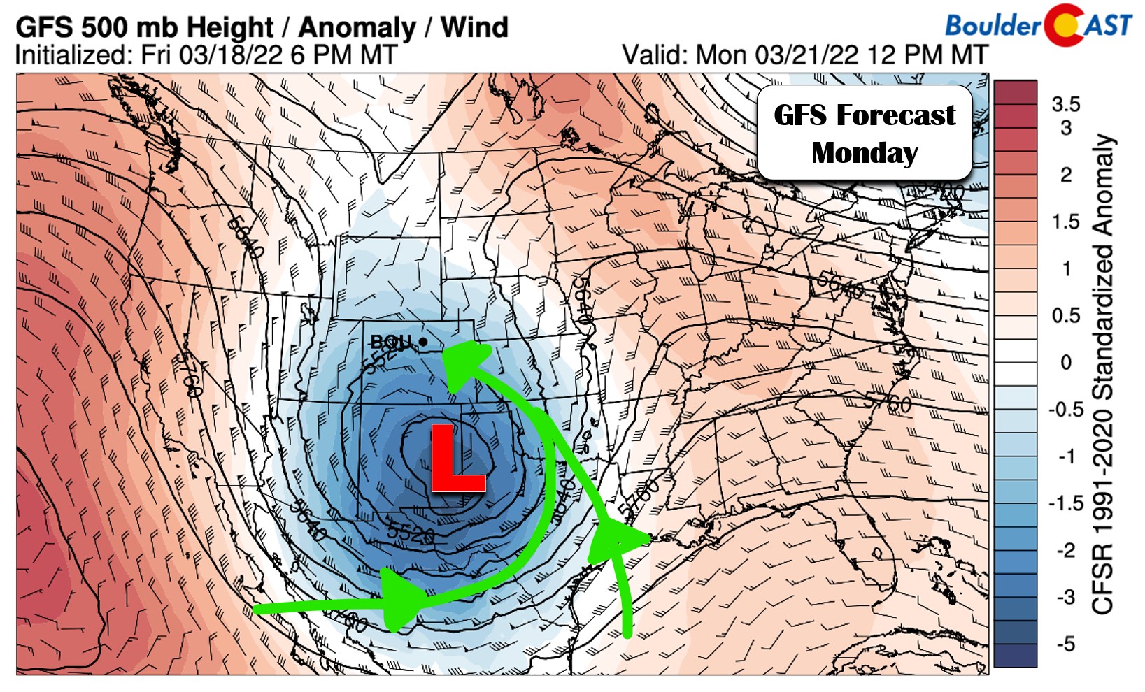
Even before our last soupy snowstorm had commenced, we were already anxiously peeking ahead to what could plausibly have been another major winter storm for our area poised to develop this upcoming Monday. However, now that the models have had a better look at this system, it has transformed into mostly a “swing and a miss” for the Denver area. The storm system in question will be coming ashore into northern California in just a few hours’ time, but the rapid intensification into a formidable low pressure won’t begin happening until early Monday across New Mexico and the Texas Panhandle. Watch the low explode in the GFS 500mb height anomaly forecast animation below.
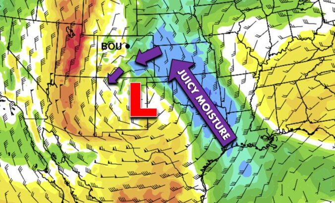
Us Front Range weather folks really start to salivate when we see a low pressure this large, this intense and in this general position. That’s because of the potential this setup has to 1) turn flow easterly across Colorado through a large depth of the atmosphere which is upslope almost everywhere east of the Continental Divide and 2) tap into deep Gulf of Mexico moisture.
The reason we have such an arid climate here is that our flow is almost always out of the west and any moisture gets squeezed out by the mountains upstream (Denver is in a rain shadow). On the contrary, though, this forecasted large-scale setup allows eastern Colorado unfettered access to a pipeline of juicy moisture and comes with strong upslope to boot — these only rarely come together in this manner (e.g. the 2 to 4 foot snowstorm in March 2021)!
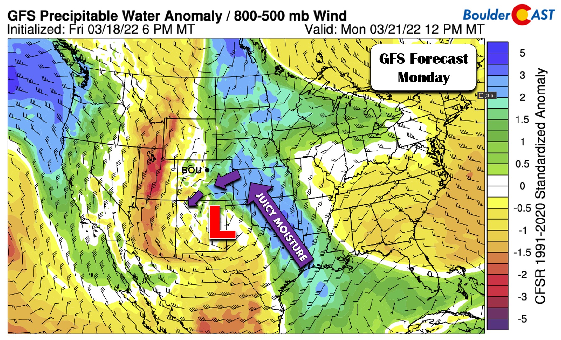
Here’s a look at the GFS moisture anomaly forecast for Monday. A low pressure of this magnitude really has a large pull — note the pipeline of Gulf of Mexico moisture flowing northward and then westward into eastern Colorado!
This setup seems so simple on paper — how could it go wrong for us? Well, as you know, due to our complex terrain, the devil is always in the details! In the case of Monday, the storm is progged to develop fairly far south. As you can see in the ensemble forecasts below, there is a strong model consensus that the cut-off low pressure will be situated along the New Mexico-Texas border by Monday evening. There’s no question here — these three ensemble suites agree on the track of the low pressure quite well (more than 100 model runs combined make up these three blended forecasts). However, notice how different the intensities are for each storm. Check out the amount and reach of the concentric circles. The GFS (top left) is much stronger than the other two models. The Canadian (bottom right) is second strongest, while the Euro (top right) is the weakest.
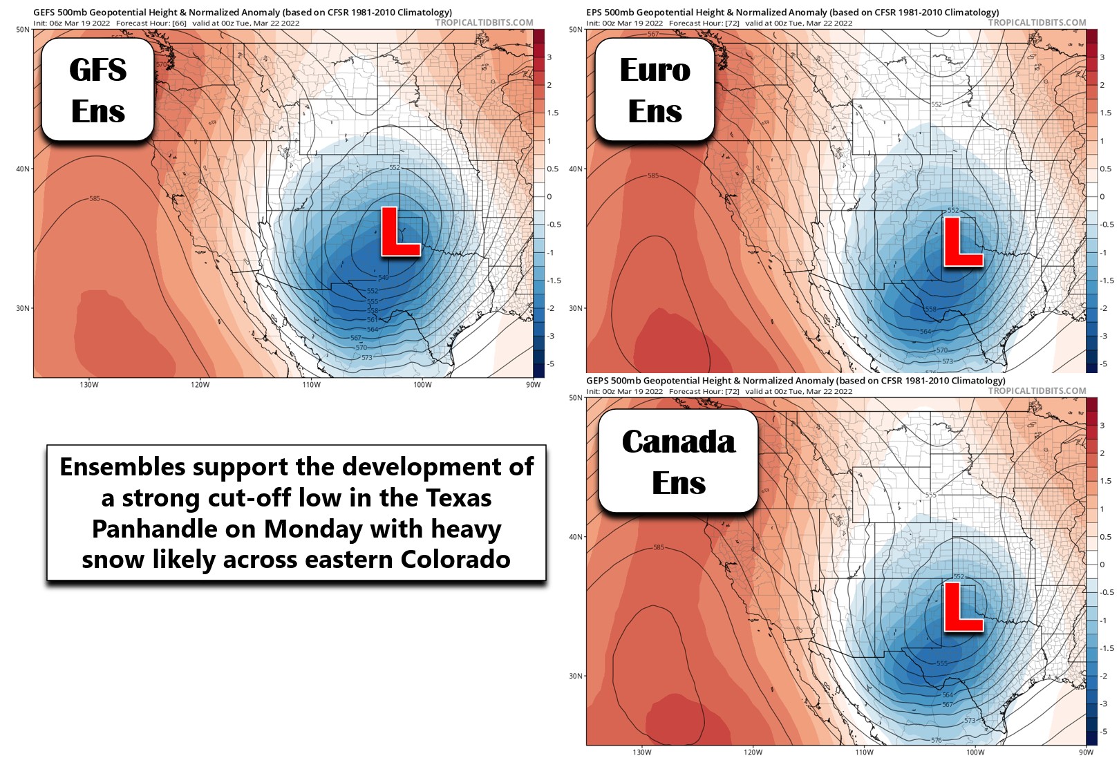
Because the track is so far south, a weaker storm like the Euro is predicting will not bode well for much action in the Front Range. Models often underestimate the amount of southward “dig” a storm will have, but rarely overestimate it. Because of this, we really don’t expect the track of this storm to shift any further north at this point. It’s not impossible, but it’s much less likely than this storm continuing to shift even further south. Model trends over the last few days have been converging towards a solution close to what the Canadian suite is showing.
So where does this leave us for Monday? Well, not in a great spot for much precipitation. Here’s a big-picture look at the 700mb forecast for Monday from the GFS. The low pressure is looking healthy across eastern New Mexico at this time, but the winds over the Front Range are strong and essentially due northerly. Northerly is NOT upslope for most of us.
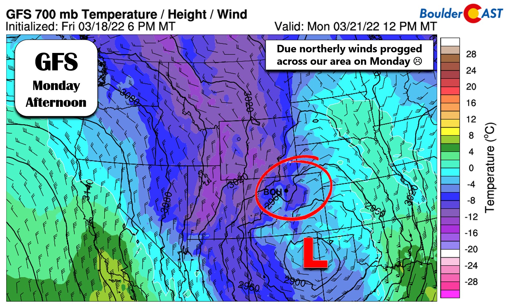
Here’s an even closer look at just Colorado. We’ve broken the eastern part of the state up into four areas worth discussing:
- From Longmont northward to the Wyoming Border: Winds won’t just be northerly, they may also have a hint of northwest flow which will certainly nix most chances for precipitation in these areas since this is downslope off the Foothills and also the Cheyenne Ridge.
- Boulder and Denver Metro areas: Flow is strong, but essentially due northerly. This will be upslope only for the Palmer Divide, but don’t expect much snow north of Interstate 70. The southern Denver suburbs like Parker and Highlands Ranch would do the best.
- Colorado Springs area: The same strong northerly flow will be present here leading to a downslope pattern off the Palmer Divide. Like so many times this winter, Colorado Springs looks to mostly miss out again.
- Area near the New Mexico border: This location has the best chance to see flow closer to northeasterly and would be excellent upslope into the Raton Mesa. Closer to the center of the low as well, this location stands the best chance to see heavy snow (Winter Storm Watches are posted here as of Saturday morning)
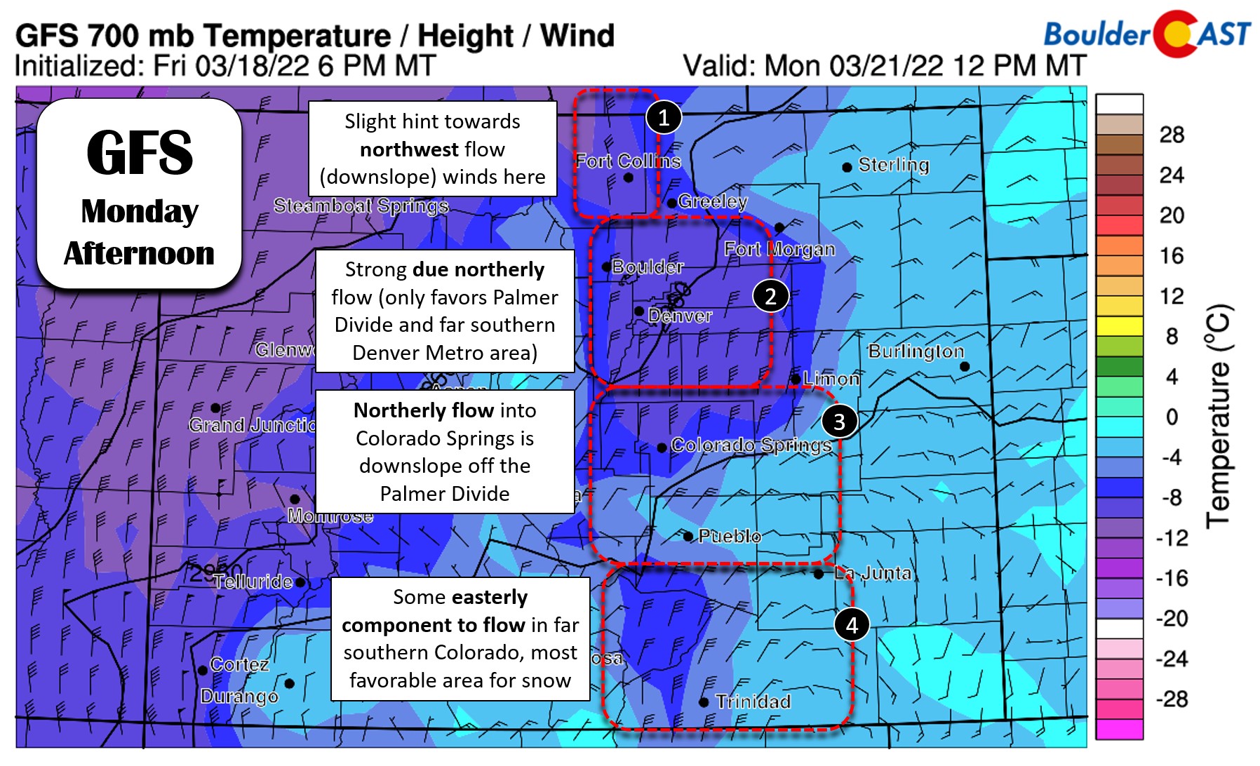
Thanks to the influence of northerly flow interacting with the terrain, all weather models are indicating resulting outcomes closely mirroring these four zones. The precipitation amount forecasts from six different models are shown below.
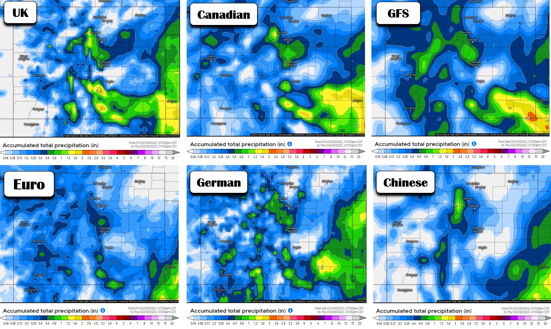
Given everything we are seeing right now, the most likely outcome in our area has only a brief chance at rain changing to snow early Monday morning as the cold front blows through with a brief shot of actual upslope. This chance of precipitation mostly ends by Monday afternoon for the Front Range. The primary window for snow is 4AM to 2PM on Monday with this system. Blustery north winds will remain through the day with highs in the mid to upper 30’s. For snow amounts, we’re not expecting a whole lot…
- Boulder and Denver: Trace-3″ with highest amounts south of Denver and next to nothing from Longmont northward
- Foothills: 1-5″, highest south
- Palmer Divide: 2-6″
Our snowfall forecast map for the event is shown below. This map covers all snow falling on Monday.
After the primary chance of rain/snow early Monday, the big ol’ low pressure is forecast to stall out over Kansas for a couple days, though we don’t quite trust the models on this one fully yet. This should keep unsettled conditions across the Front Range with chilly temperatures, clouds, and a slight chance of continued rain/snow showers with highs in the 40’s. These subsequent days likely won’t accumulate much precipitation or snow for us either. Like we said earlier, a big “swing and a miss” if you will.
Though things are turning colder and more unsettled beginning Monday, it will be beautiful for the weekend at least. Enjoy!
Get BoulderCAST updates delivered to your inbox:
Help support our team of Front Range weather bloggers by joining BoulderCAST Premium. We talk Boulder and Denver weather every single day. Sign up now to get access to our daily forecast discussions each morning, complete six-day skiing and hiking forecasts powered by machine learning, first-class access to all our Colorado-focused high-resolution weather graphics, bonus storm updates and much more! Or not, we just appreciate your readership!

Enjoy our content? Give it a share!


You must be logged in to post a comment.