
Another Wednesday, another winter storm is going to hit the Front Range! A Pacific trough will impact the area Wednesday into Thursday bringing a return of the white stuff to the Boulder-Denver Metro. Unlike the last handful of snowstorms, this one will have just enough cold air to turn rain over to snow across the entire area. Snowfall amounts remain somewhat uncertain, but most of us should expect at least a couple inches of slushy snow by midday Thursday, with much more in the higher terrain. Let’s take a look at our first “warm” winter storm of the season!
At a Glance:
- A spring storm will bring widespread rain and snow to the Front Range Wednesday into Thursday
- Models have been trending upward in moisture amounts with this system — we’ll cautiously say that it now looks to be a soaker!
- Things will begin as rain across the lower elevations Wednesday afternoon, but a change-over to snow is expected during the evening hours
- Temperatures just barely drop below freezing Wednesday night, so this snow will be soupy!
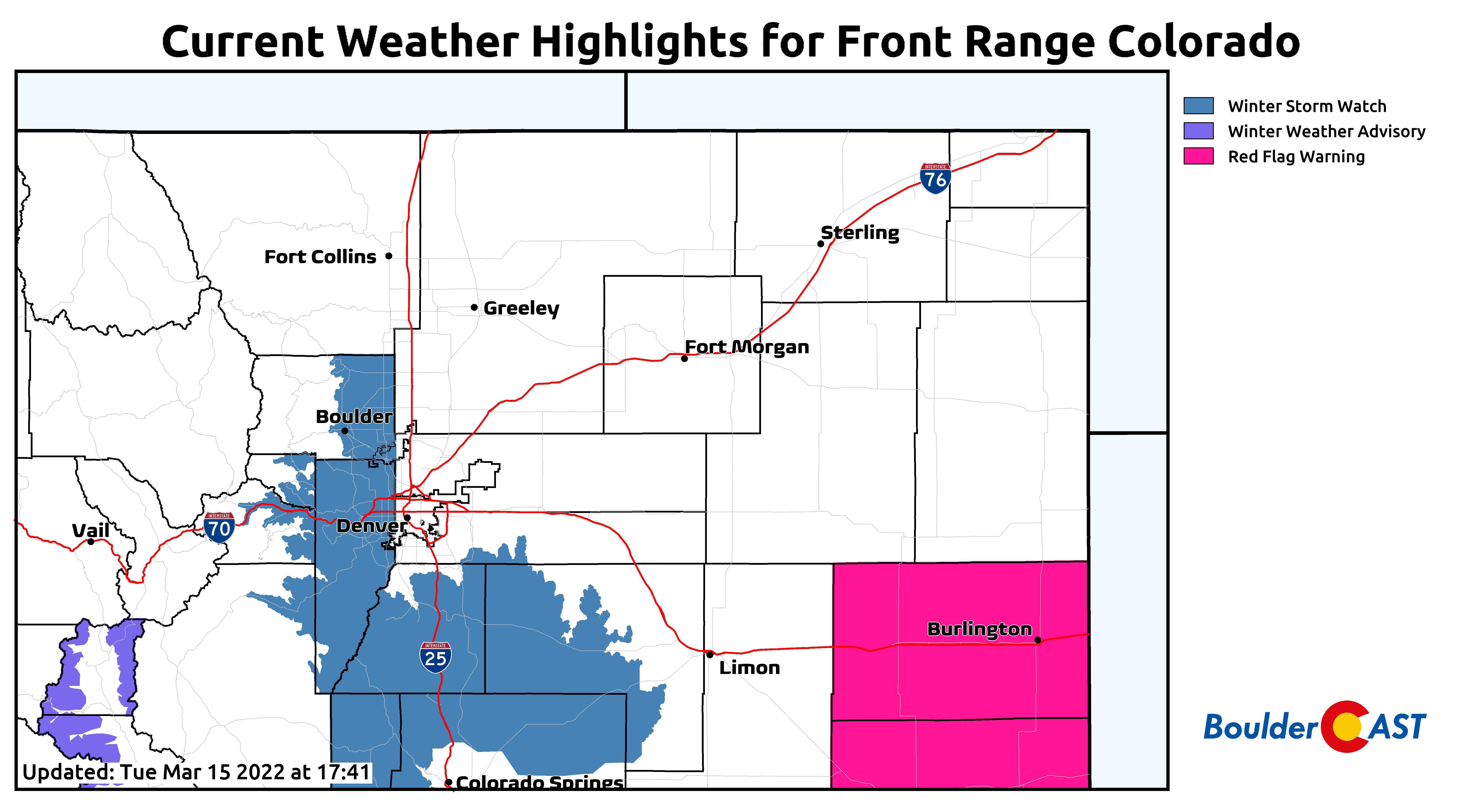
- A Winter Storm Watch has been posted for Boulder, as well as western and southern suburbs of Denver
- Snowfall amounts are still uncertain but we expect a couple slushy inches in most areas with up to 12″ in the Foothills
T
emperatures soared to near 70 degrees this afternoon, but tomorrow is Wednesday and you know what that means — it’s either going to rain or snow, or both! We’ve heard the sentiment from our readers for weeks now mentioning that Wednesday has seemed preferentially snowier than other days of the week. As it turns out, they were right! So far in 2022, Boulder has reported 16.6″ of snow and 1.05″ of precipitation on Wednesdays, more than any other day of the week. In terms of the occurrence of rain and snow, Wednesday sits in second place behind Thursday.
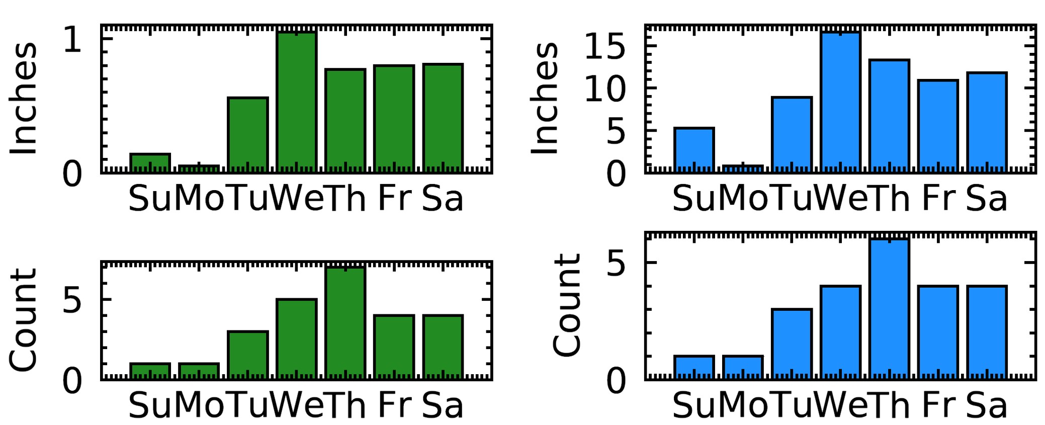
Precipitation (left) and snowfall (right) data for Boulder in 2022 by day of the week (through March 10th)
This Wednesday will be different than those of recent weeks or months. While it will (eventually) snow for our entire area, the incoming storm is distinctly spring-like in nature, lacking the Arctic air that we’ve grown accustomed to over the last few months alongside our snowstorms. The use of a broom to dust away several inches of powder from the sidewalks will no longer be viable, especially for this week’s storm which will be towards the soupier end of the spectrum.
This storm in question is just now coming ashore in the Pacific Northwest. It will deepen by tomorrow, but honestly it digs pretty far south as it crosses the Rockies. This southern track, along with the quick-moving nature of this system in general, both remain a concern for us as we have discussed the last few days. Notice in the animation below that most of the consolidated energy develops in New Mexico and Texas. This isn’t a typically fruitful track for Front Range precipitation — this is one we would expect to favor Colorado Springs more so than Denver.

GFS 500mb height anomaly forecast animation for Tuesday into Thursday evening
Despite this, we do note excellent model support for rather impressive moisture totals with this system, owing largely to a 12+ hour window of somewhat favorable upslope, embedded instability and high moisture availability within this spring storm. Both the GFS and NAM models are producing more than 0.75″ of precipitation for Boulder and Denver and areas to the southwest.
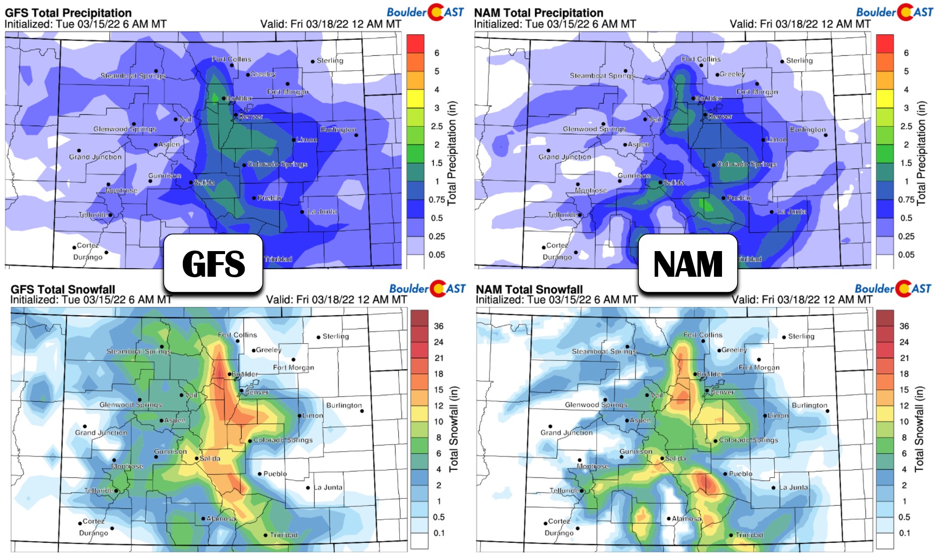
We also see strong ensemble agreement for those very same precipitation amounts. The GFS ensemble mean precipitation amount for Boulder is around 1.2″ (shown below) with 1.0″ in Denver. The European ensemble means (not shown) are 1.0″ in Boulder and 0.85″ in Denver. If the models are to believed, a healthy dose of moisture is on the way!

Of course, we haven’t yet addressed the elephant in the room: temperatures! It’s very warm today (Tuesday), and it will be fairly warm tomorrow as well. When the precipitation begins Wednesday afternoon into the evening, it will most certainly begin as rain across the lower elevations and even a good chunk of the Foothills. It’s that time of year (i.e. spring!). There’s a solid likelihood that anywhere from a quarter to half of this storm’s moisture output will fall in the form of rain instead of snow. This will cut into snowfall totals.
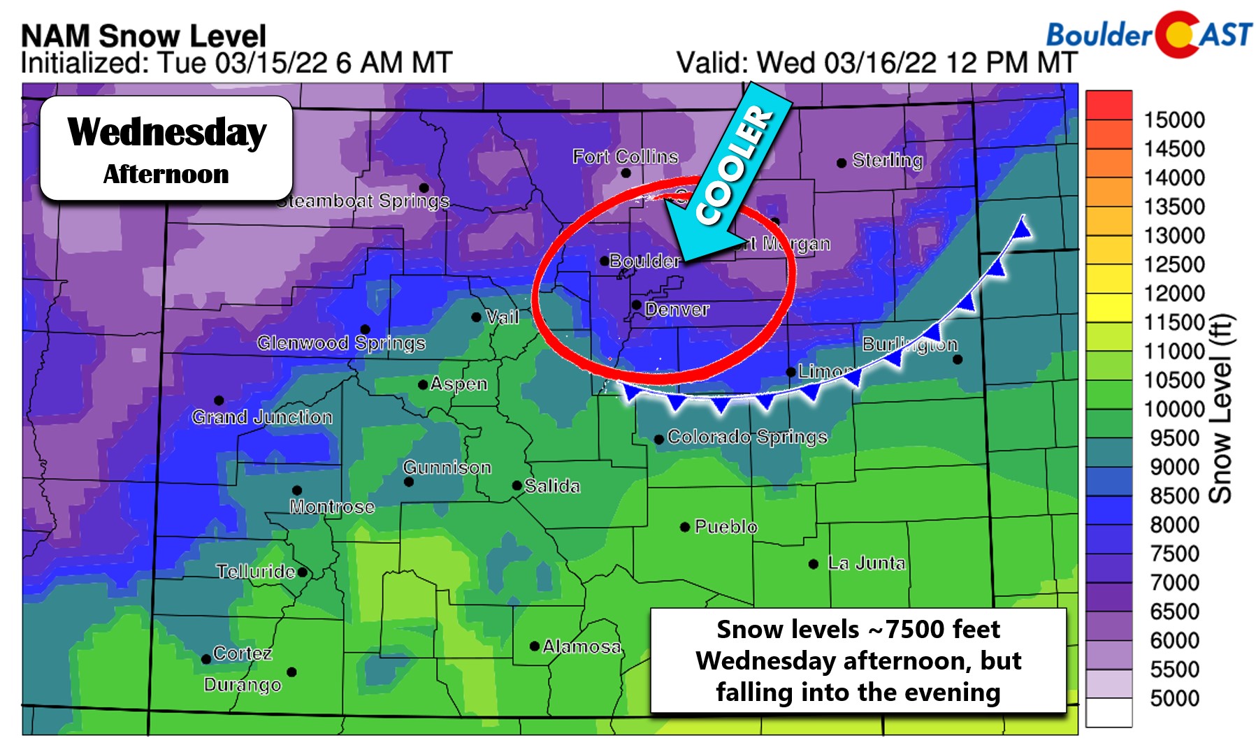
Snow levels Wednesday afternoon will be near or above 7500 feet elevation. Things will start as all rain in Boulder and Denver, but with snow higher up.
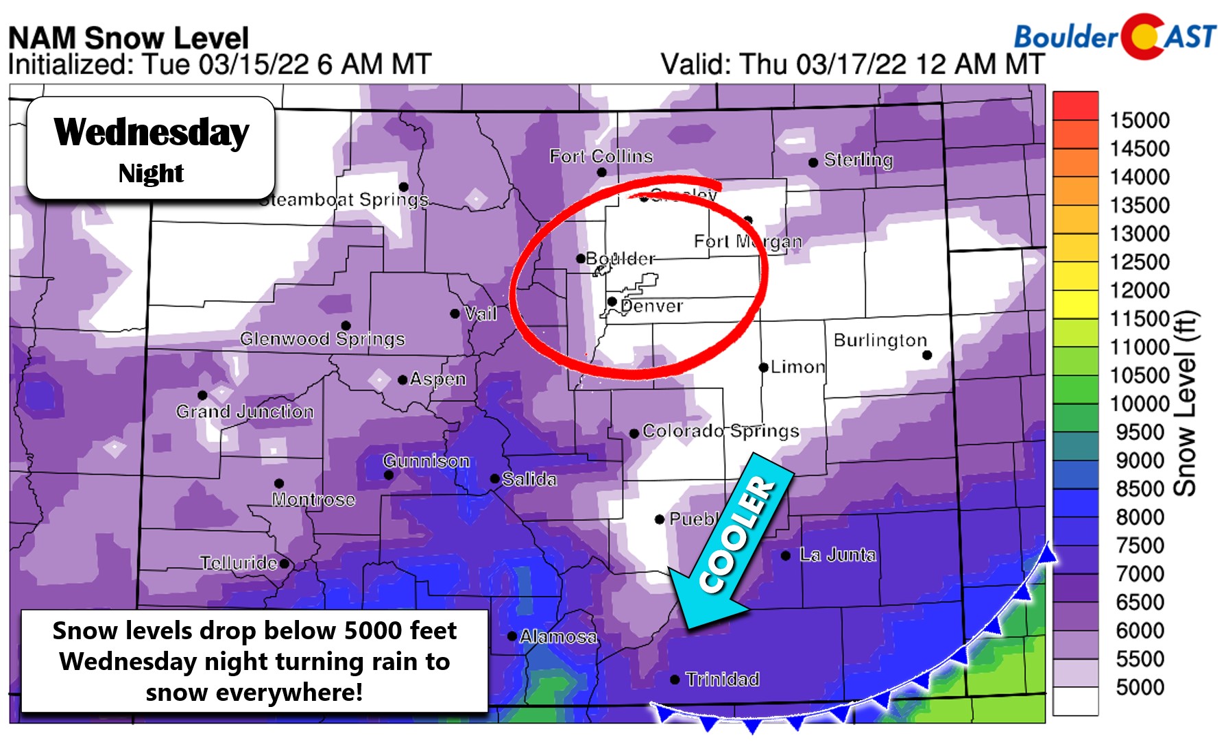
As the low pressure in New Mexico and Texas intensifies, it will help to drag a cold front southward through eastern Colorado with falling temperatures expected through the afternoon and evening in the Denver area. By 6PM, snow levels will be dropping further below 6000 feet:
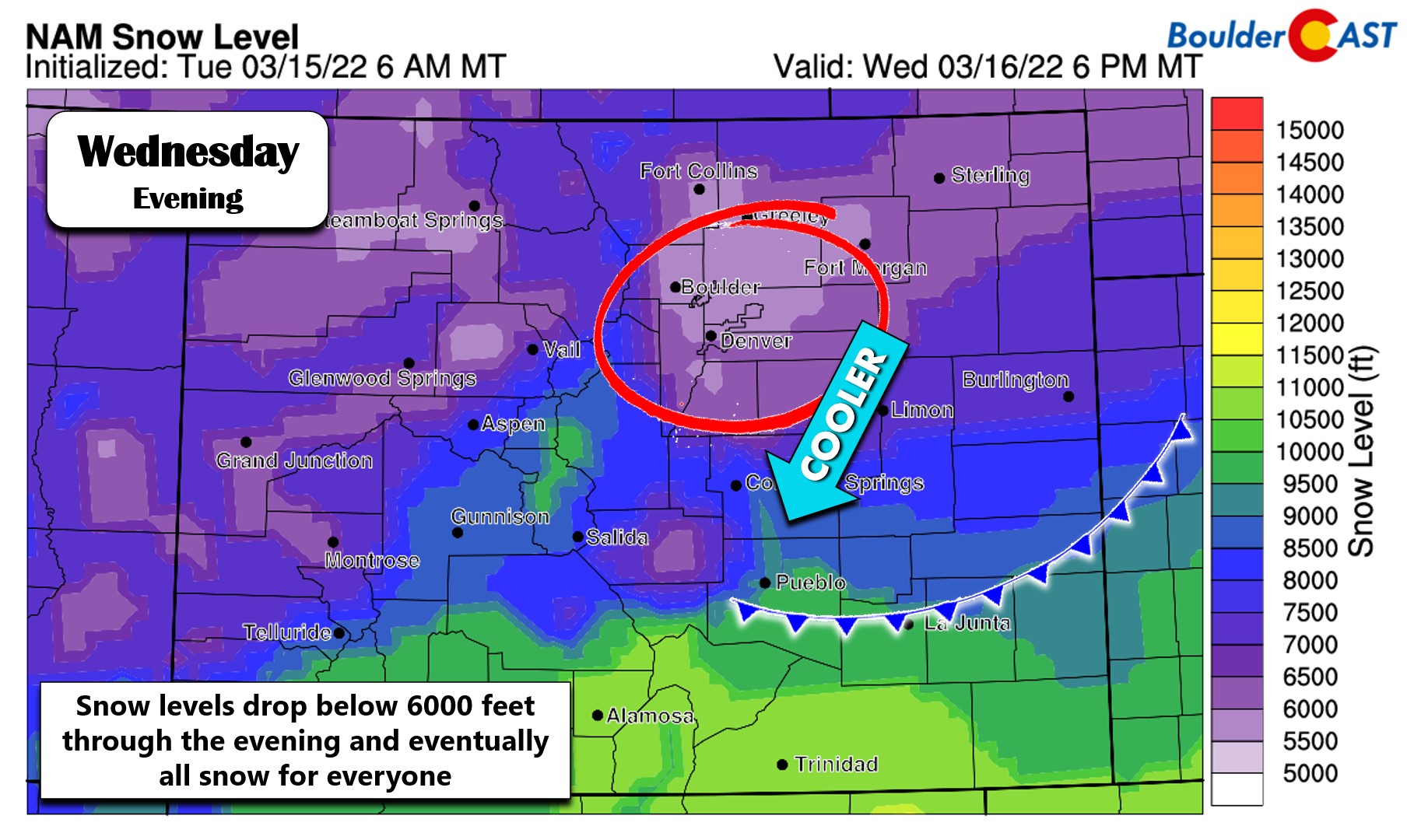
And finally, during the late evening and overnight, temperatures will cool enough to turn rain to snow for the entire area:
The change-over timing will obviously be a key factor in potential snowfall totals across the Front Range. Most model guidance indicates that rain will turn over to snow for the lower elevations between 7PM and 10PM Wednesday evening, earlier in the higher elevations of course. Given the expected intensity of the precipitation during the evening, it wouldn’t be surprising to see the change-over to snow occur earlier than this as is often the case with these dynamic spring storms. The simulated radar animation below from the HRRR model shows a fairly intense wave of precipitation dumping on the Denver Metro area Wednesday night after sunset!

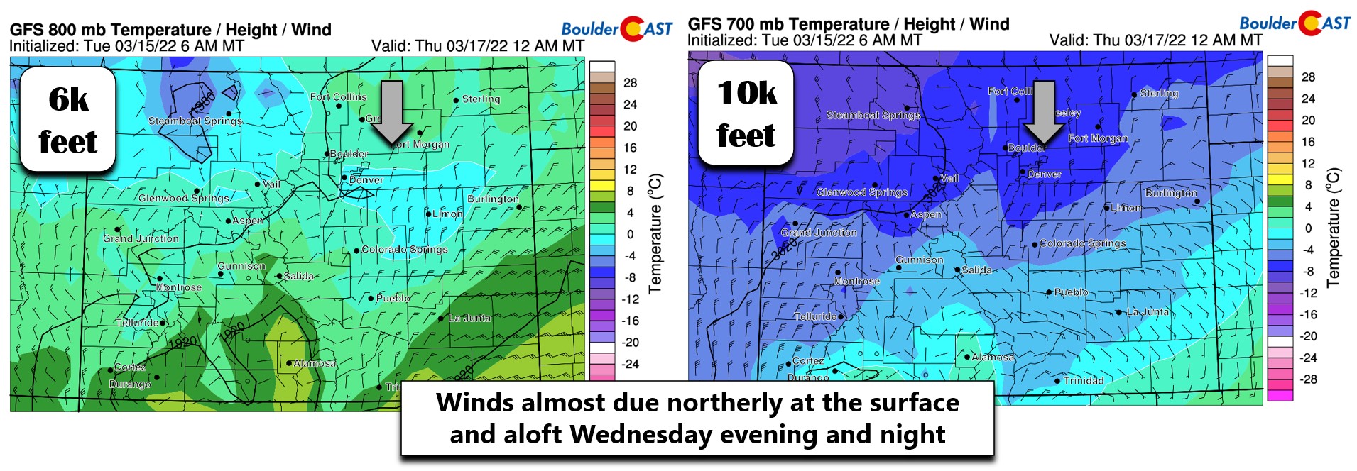
To play devil’s advocate, it also wouldn’t be at all surprising to see a later change-over timing as well. The winds through much of the atmosphere will be northerly Wednesday night (see below). At the surface this tends to have a warming effect for Fort Collins, Longmont and even sometimes Boulder with downslope coming off the Cheyenne Ridge. Even the miniscule 1 to 3 degrees of warming this could introduce may be enough to keep temperatures above freezing longer, delaying the change-over and even preventing snow from sticking once the change-over occurs.
As you can see, there is still a lot to work out in this forecast with this storm despite the inaugural raindrops being just 24 hours away. Here are some of the questions we’ll be working to pin down by early Wednesday:
- Given the somewhat atypical track for Front Range precipitation, will the models continue to “stick to their guns” of producing almost implausible precipitation amounts for us? We think the models could back off tonight or tomorrow morning, but maybe not!
- When will the change-over from rain to snow happen? Earlier = more snow. Later = less snow. We’re still not sure which way this one will go.
- Will temperatures actually drop below freezing everywhere to allow adequate accumulation of the falling snow? What falls isn’t always what sticks this time of year!
The National Weather Service has just issued a Winter Storm Watch for the western Denver Metro area (including Boulder) and the Palmer Divide for the period of 6PM Wednesday to 6PM Thursday.
Given the complexity of the storm, we’ll need to see a few more model runs before nailing down our final snowfall forecast and publishing our usual snowfall map you know and love. For now, the list below is roughly what we are thinking for the region. Remember that forecasted snow amounts remain quite uncertain. They can and will likely change at least a little between now and tomorrow!
- Immediate Boulder area: 3-6″
- Longmont to Loveland: Dusting to 3″
- Louisville/Superior: 2-6″
- Broomfield/Westminster/Arvada: 2-5″
- Downtown Denver: 2-5″
- Denver International Airport: 1-5″
- Parker/Centennial/Littleton/Golden: 3-7″‘
- Foothills: 5-12″, locally higher totals possible in Jefferson County
- Palmer Divide: 5-10″
Wednesday will be cooler with highs in the 50’s under extensive cloud cover. Precipitation should commence in the afternoon to early evening in the form of rain before changing over to snow during the evening hours sometime. Snow will continue into Thursday morning, heavy at times during the overnight. We may see a lighter mix of snow and rain linger into Thursday afternoon. Highs on Thursday will be in the upper 30’s.
Try to enjoy what’s left of the warmth this evening if you can. We’ll have our final update out tomorrow. Stay tuned and stay subscribed…
Get BoulderCAST updates delivered to your inbox:
Help support our team of Front Range weather bloggers by joining BoulderCAST Premium. We talk Boulder and Denver weather every single day. Sign up now to get access to our daily forecast discussions each morning, complete six-day skiing and hiking forecasts powered by machine learning, first-class access to all our Colorado-focused high-resolution weather graphics, bonus storm updates and much more! Or not, we just appreciate your readership!

Enjoy our content? Give it a share!


You must be logged in to post a comment.