A quick round-up of precipitation and snow totals from Wednesday’s over-producing winter event.
It’s been a busy weather-week across northern Colorado, but we’re not complaining!
Rain began to develop across the Metro area Wednesday afternoon and quickly turned to snow by early evening for most locations. The precipitation was stronger and more widespread than we had forecast. The weather models never really caught onto this happening, even in the last few runs of the GFS and Euro, or the dependable high-resolution HRRR model. By late morning Wednesday, we had a feeling this storm could be an over-producer given the intensity and breadth of the snow falling upstream across southern Wyoming. The models had clearly under-forecast there as well. The jet was most likely the difference-maker in our opinion. The banding visible on radar Wednesday evening was unmistakably jet-streak related.
Here’s a look at the radar-estimated precipitation totals for the storm:
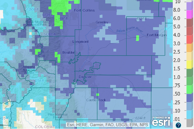
March 28-29 precipitation totals for Front Range Colorado.
Most places picked-up between 0.25 and 0.5″ of needed moisture, a bulk of which fell as as wet snow. We did get the overall precipitation pattern correct. The highest totals were indeed focused across Larimer County to the north of Boulder.
The snowfall analysis map below for the event shows light accumulations across the Plains (0 to 2″), with slightly higher amounts in the Foothills (2 to 5″).
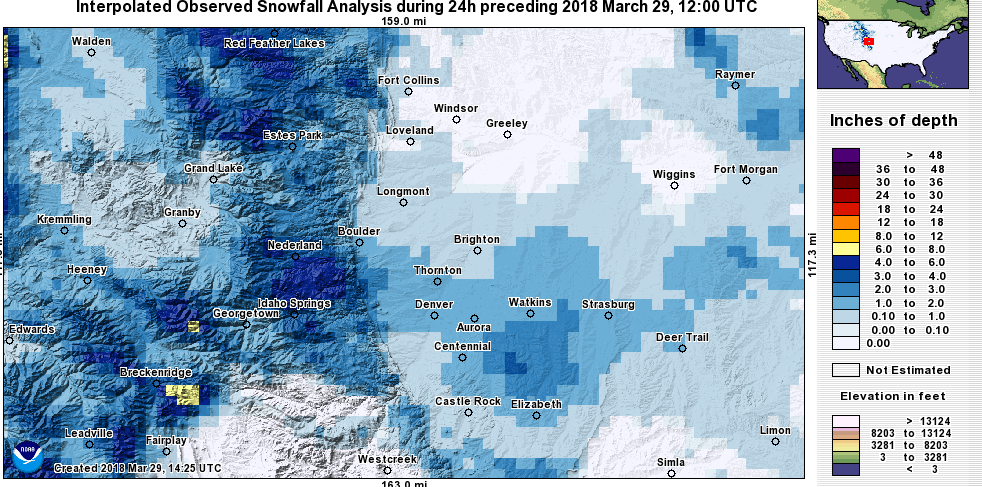
March 28-29 snowfall totals for Front Range Colorado.
Despite the bonus moisture dumped on us, the snowfall map above looks a lot like our forecast. There was significant melting across the lower elevations, with accumulation mainly confined to grassy areas. Even with the heavy snow and large dendrites, temperatures in the middle 30’s and the late-March sun were a major hurdle for accumulation.
Shown below is our original snowfall forecast map (issued Wednesday morning), with the observed storm totals per location contained in boxes. Green ones indicate that the observed snowfall was within one inch of the given forecast range, while red was outside the scope of our forecast.
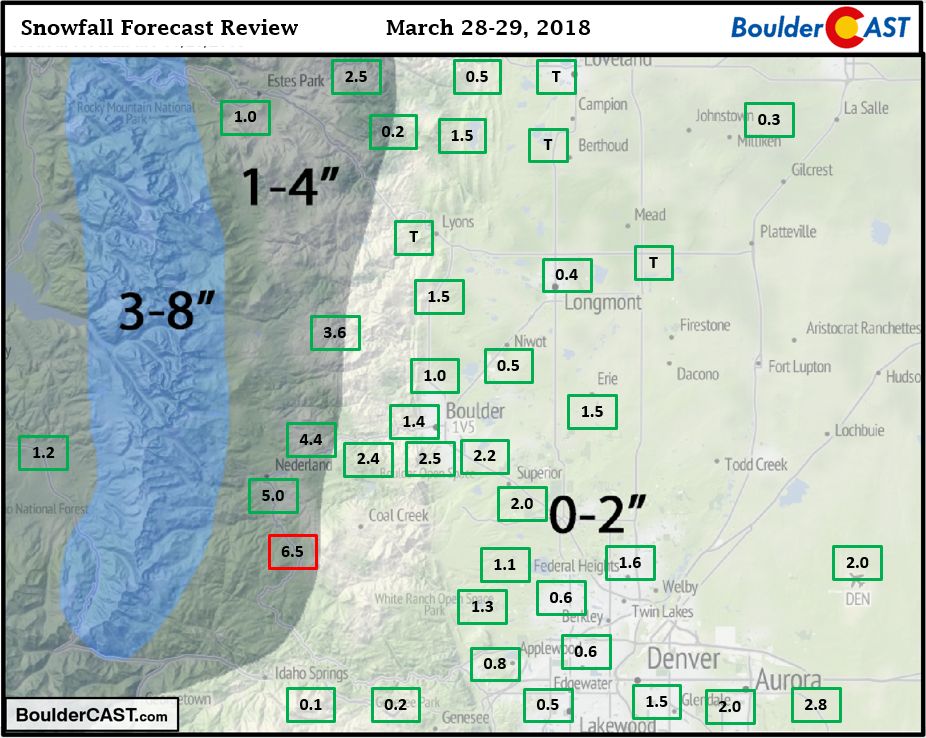
All green, save for a lone 6.5″ snowfall report in Gilpin County south of Nederland. The official snow total in Boulder was 2.5″ with about 0.5″ of liquid. Even Denver International Airport managed to snag another 2.0″ of snow.
NWS check: Their forecast ended up being very similar to ours, and verified just as well. They predicted 1-2″ for the Plains, with “larger amounts” in the Foothills.
For the ski resorts, today’s reports indicate the storm was also a slight over-producer for the High Country. Most resorts met or slightly exceeded our PowderCAST forecast. Breck was the surprising winner with 8″ of fresh powder this morning! As you can see below, 21 out of 22 resorts had snow totals within 3 inches of PowderCAST. Actual reports are below in large green/red text to the left of the resort names.
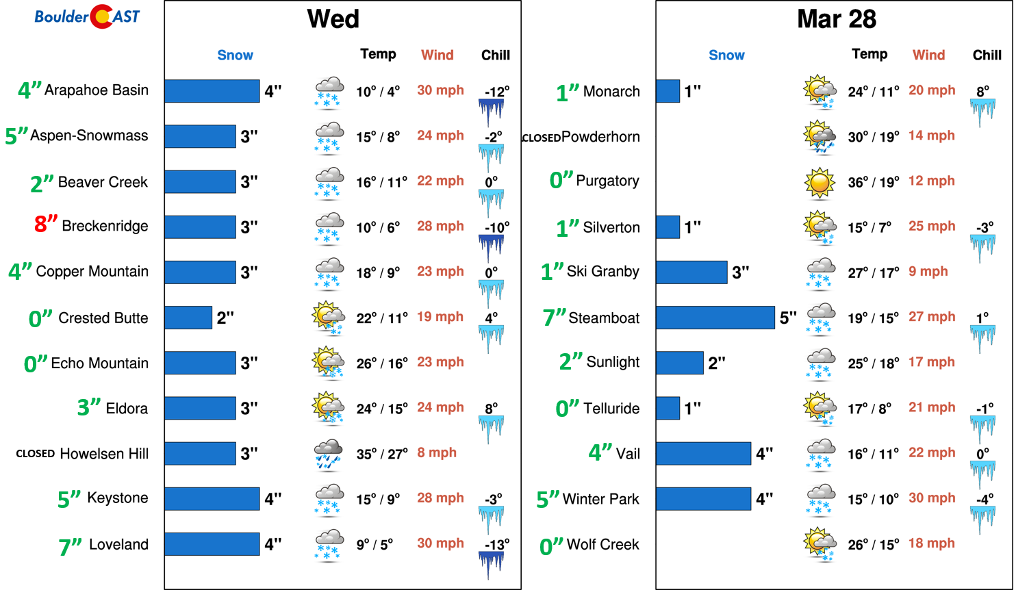
PowderCAST verification for March 28-29 snow.
Head over to our 2017-18 Winter Summary page to check up on our seasonal snow totals.
Upcoming weather
According to model ensembles, a perturbed northwest flow will remain across Colorado through Sunday, before turning more zonal. A couple more weak disturbances will be present and will impact northern Colorado. The first is later this afternoon and evening, which will bring isolated rain/snow showers for us (no accumulation expected!).
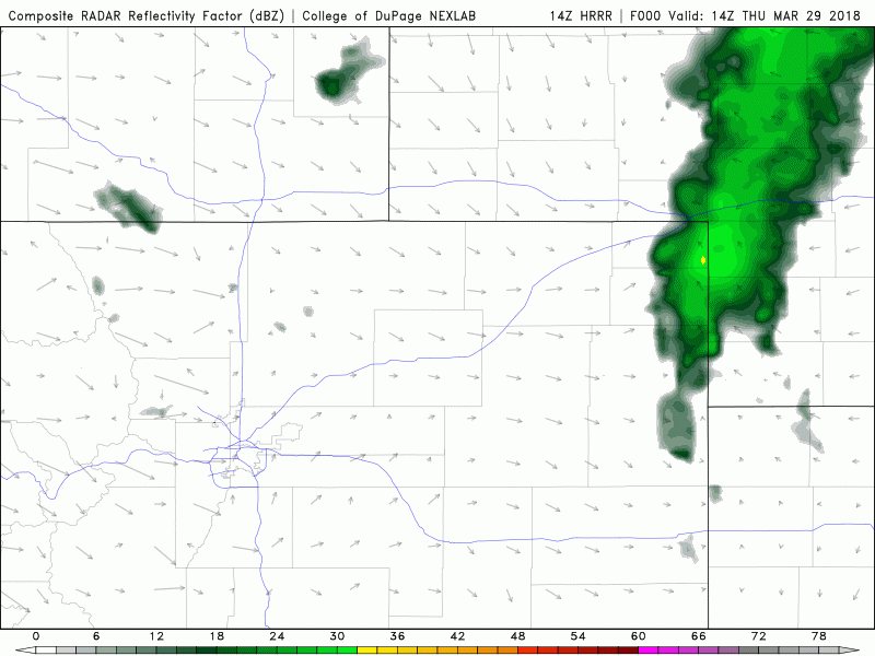
HRRR simulated radar for Thursday afternoon and evening. A few showers will be possible across the Metro area.
The second wave looks slightly more substantial, and will be something to watch to spread more rain and snow to the region Saturday evening. Latest runs of the GFS keep most of the precipitation near the Wyoming border, but things can definitely change. Stay tuned…


You must be logged in to post a comment.