Wednesday may have felt underwhelming across the lower elevations of the Front Range, where lingering low clouds kept things calm and cool for much of the day — but just west of Boulder, up in the sunshine-soaked Foothills, something rare and striking took shape Wednesday afternoon. A graceful funnel cloud twisted above the mountain peaks in a spot where such phenomena almost never occur. We explore why tornadoes (and their funnel-shaped precursors) are so uncommon in Colorado’s higher terrain, and take a closer look at what makes broader Boulder County particularly adverse to tornado development.
The tale of the missing sun
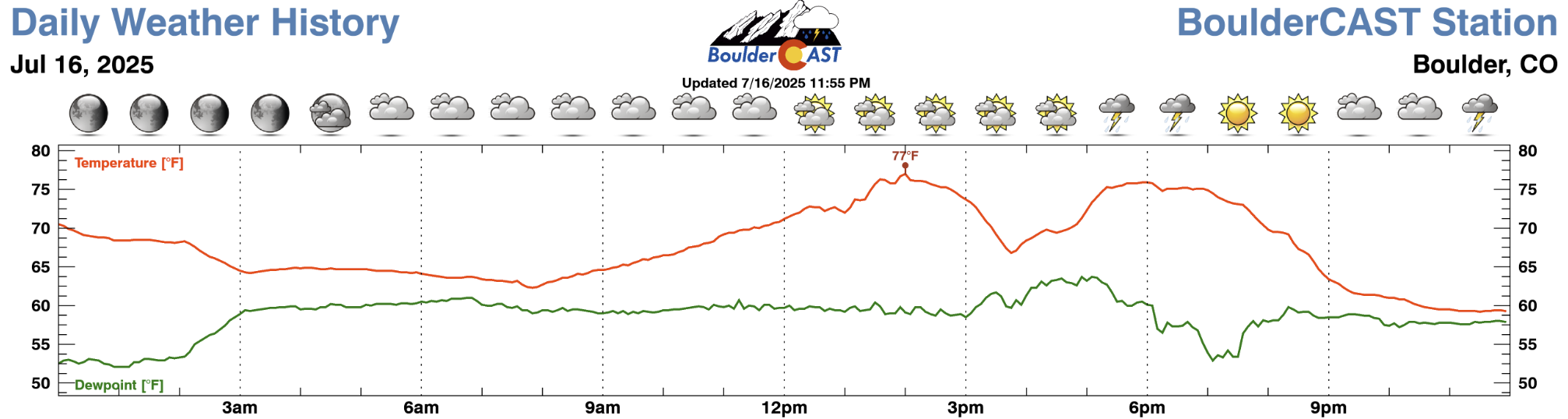
Wednesday brought an active weather setup across the Front Range, but it didn’t quite turn into the full-blown severe storm outbreak that could have been. The morning hung on to its low clouds a bit too long, finally clearing out in the early afternoon—just in time to be replaced by new cloud layers higher up. That left barely an hour of sunshine across the lower elevations, which just wasn’t enough. The map below shows high temperatures from Wednesday — only a few places actually touched 80°, the approximate temperature that was needed for severe storms to develop en masse.

High temperatures observed on Wednesday July 16 2025
Our station only reached 77°F during the afternoon hours before storm clouds and rain passed through cooling us off. There just wasn’t enough sunshine to prime the atmosphere for explosive storm growth on Wednesday. It’s an all too familiar story for our area: morning low clouds stubbornly holding on and ultimately nixing what could otherwise be an explosion of severe storms.
Meanwhile, in the Foothills…
Things looked quite different up in the higher elevations—above 7,500 feet, where the sun was out much earlier. That gave the atmosphere a jumpstart, and storms started forming by early afternoon.
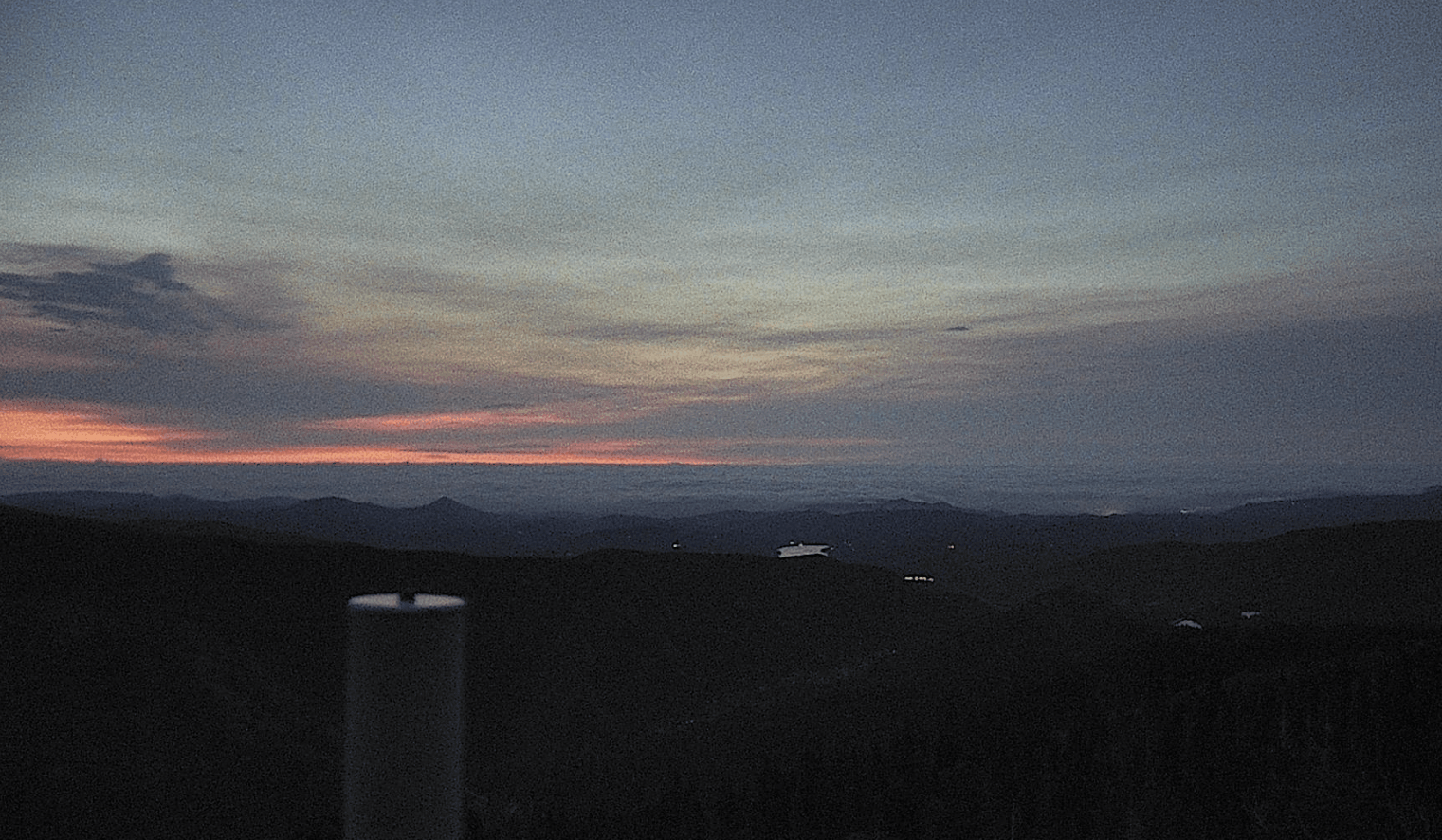
View from Eldora looking east Wednesday morning at sunrise. The lower elevations are blanketed in low clouds and fog, while a layer of lofted smoke is visible even higher up.
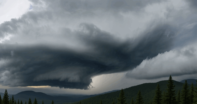
One of the first hit western Boulder County hard, turning severe as it rolled through Nederland and Ward, eventually reaching Arvada and Golden. It even dropped hail as big as 1″ in diameter. This storm is shown below, blowing up as it came over the Mountains into the Nederland area.

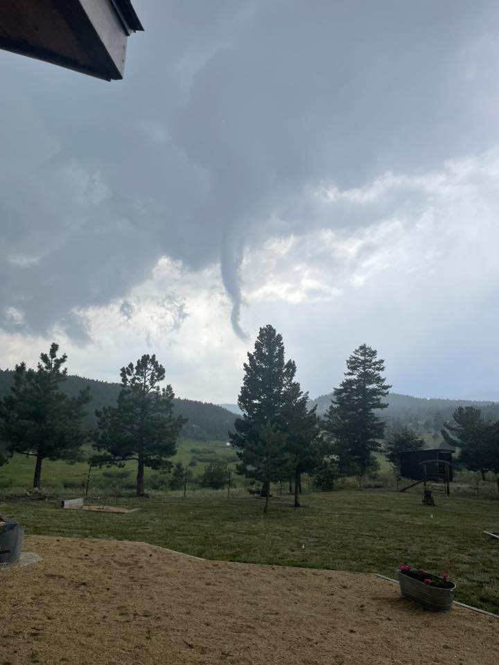
As it was forming, a brief but dramatic funnel cloud spun up near Nederland. Barb Panneton was one of the first to notice it, snapping the photo below. The last just a few minutes before rapidly dissipating.
Soon we started getting more photos from all over Boulder County, including this one from Ian Taylor in Lyons:
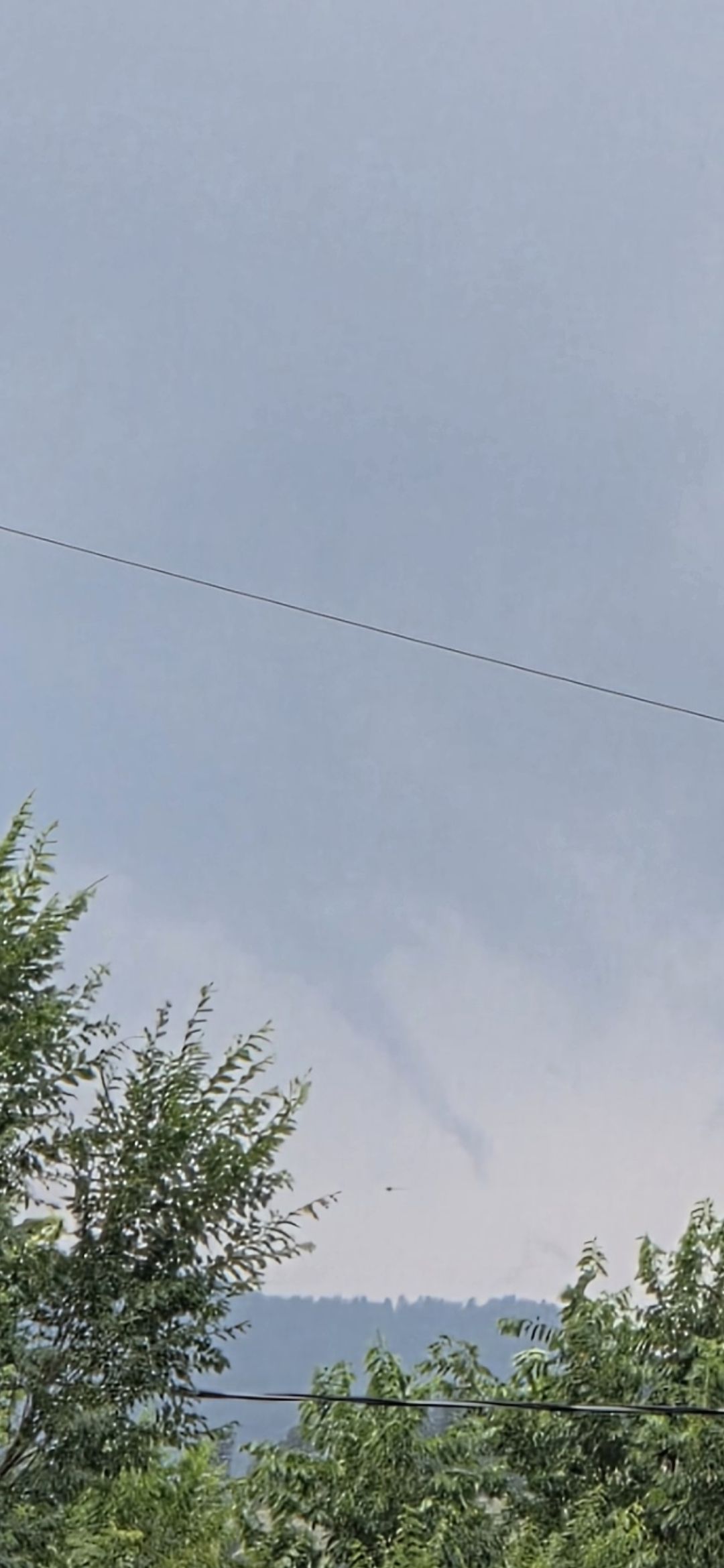
And this one from Mary DeBroux in Sugarloaf (several miles northeast of Nederland):
We even found some incredible webcam footage, including time-lapses that showed the funnel cloud forming and twisting against the backdrop of the snow-dotted Continental Divide (credit: Barb Panneton for the webcam, Ryan Vandersmith for splicing the video):
Here’s another timelapse of the same funnel from a webcam in the heart of Nederland (webcam credit of Busey Brews Smokehouse & Brewery):
We saved the best for last — a video captured by someone on the ground and much closer to the actual funnel (credit Anonymous). We’re not sure where this was taken exactly, but it seems to be somewhere near Ward. Wow!
Tornado or not?
Nope, not officially. To be classified as a tornado, the rotating vortex of air must make direct contact with the ground. Usually this is visually confirmed by the condensed cloud droplets of the funnel itself reaching the ground, or by dust getting picked up from the surface and pulled upward. It’s hard to tell, but the very beginning of the video above almost looks like a possible touchdown, though the very base is obscured by the trees and it cannot be 100% confirmed. With so many other videos and photos of the same funnel and no other indication of a touchdown, it seems quite unlikely this was anything more than an dramatic funnel cloud.
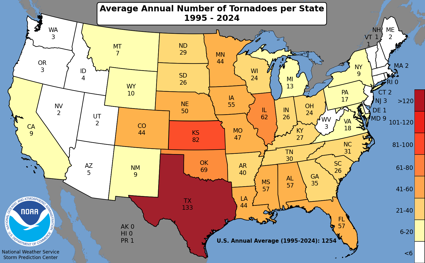
Despite not being a true tornado, the funnel cloud on Wednesday is remarkable in its own right. Yes, Colorado is one of the more active states in the country in terms of tornadoes, averaging about 44 per year.
However, very few tornadoes (and funnel clouds) actually form west of Boulder in the state. Why is that? Mountains. Big mountains, of course!
Funnels, and the tornadoes they can morph into, are rare in mountainous terrain due to a mix of factors that make conditions less favorable for their formation up there. These include:
- Cooler, Drier & More Stable Air: Higher elevations tend to have cooler temperatures and lower dew points (moisture), which leads to more stable air. Tornadoes thrive in unstable environments with warm, moist air near the surface and cooler air aloft—conditions less common in mountainous areas.
- Disrupted Wind Shear: Tornado formation relies on organized wind shear—winds changing speed and direction with height. Mountain terrain disrupts this smooth vertical wind profile, making it harder for rotating updrafts (mesocyclones) to develop.
- Sloped Terrain Challenges: The rugged topography of mountainous terrain interferes with thunderstorm structure and organization. Slopes can break up storm cells or prevent the vertical stretching needed for tornado genesis. They also disrupt the influx of warm, moist air which is the lifeblood of a supercell thunderstorm.
Furthermore, Boulder County is far from a tornado hotspot, even across the relatively unvarying flats of the eastern third of the county. We’re just too close to the terrain — some of those aforementioned tornado-busting effects from the nearby Mountains and Foothills protect us in a similar manner. And low clouds—like Wednesday’s— can completely ruin an otherwise good severe weather setup. Eastern Boulder County, where moist upslope first encounters significant opposition from the terrain, is often the last in the Denver area to have such cloud decks dissipate.
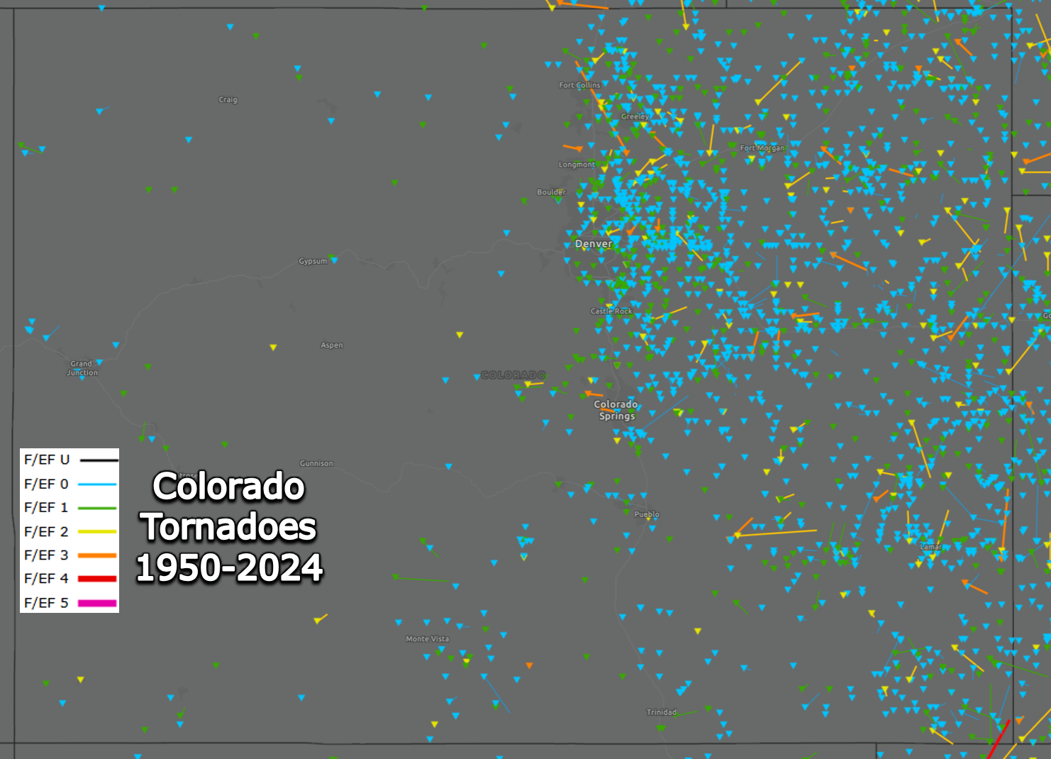
Fun Fact: Boulder County hasn’t had a confirmed tornado in over 10 years, the last being the rare westward-tracking EF3 twister north of Longmont in June of 2015 (orange line below). Since 1950, there’s only been been 9 confirmed tornadoes in the county (11 if you count the land to the southeast which has since been annexed by Broomfield), and only one of those occurred above 5500 feet elevation. That one touched down just east of Nederland in June of 1996 near Pinecliff and tracked on the ground for approximately 1.5 miles, was around 300 yards wide, and destroyed mostly trees and a few minor structures. No injuries were reported. And if you’re wondering, the historical record only includes reported tornadoes. It’s possible, especially before the recent population booms, that some tornadoes in the higher terrain have eluded human eyes or were never officially reported since 1950. And brief funnel clouds that don’t touch down do not count either, though we will say there has been at least a few Boulder County funnel clouds reported to our team over the last decade or so but none of those were in the Foothills.

While dramatic in appearance, yesterday’s funnel cloud was fortunately harmless. It was a reminder that nature doesn’t always need destruction to be impressive. What made this moment particularly special was the sheer volume of community engagement: photos pouring in; time-lapses stitched together with care; and readers chiming in with their own stories and perspectives about one lonely cloud in the sky. It wasn’t just a weather event — it became a shared experience for Boulder County. Wednesday’s funnel cloud won’t be added to the tornado record books. It will never appear in official storm logs or databases. But its legacy lives on in the way it brought people together.

Go Premium, get all the perks.
Daily Forecast Updates
Get our daily forecast discussion every morning delivered to your inbox.
All Our Model Data
Access to all our Colorado-centric high-resolution weather model graphics. Seriously — every one!
Ski & Hiking Forecasts
6-day forecasts for all the Colorado ski resorts, plus more than 120 hiking trails, including every 14er.
Smoke Forecasts
Wildfire smoke concentration predictions up to 72 hours into the future.
Exclusive Content
Weekend outlooks every Thursday, bonus storm updates, historical data and much more!
No Advertisements
Enjoy ad-free viewing on the entire site.
Enjoy our content? Give it a share:


You must be logged in to post a comment.