The well-advertised dip in the jet stream set to bomb out across eastern Colorado is still very much on-track to end the work week. The forecast for this springtime beast has remained largely unchanged since our last forecast update on Monday when we detailed that this monster storm would primarily be a wind-maker for us. We discuss which parts of Colorado will see the strongest winds, where the limited rain and snow will fall, and the ensuing mess this storm will cause as it races across the nation in the days ahead. Read on for the latest details.
At a Glance
- Storm Overview: A powerful storm is set to bring mountain snow, strong winds, blowing dust, and a few raindrops to eastern Colorado as a Pacific trough and associated jet streak will fuel explosive cyclogenesis on Friday.
- Powerful Winds: The strongest wind gusts (over 55 MPH) are expected well east of Denver into Kansas and Nebraska. Boulder-Denver area will see gusts in the 30-50 MPH range.
- Minimal Precipitation Down Low: Limited precipitation is expected in eastern Colorado, with only brief, light wind-infused rain showers. Snow will occur along the Palmer Divide with minor accumulations possible.
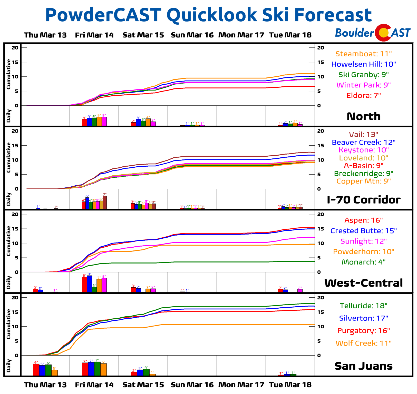
- Mountain Snow: Significant snow and wind are expected in the Mountains, with 3 to 10 inches in the central and northern ranges and up to 20 inches in the San Juans, falling by Saturday morning.
- Nationwide Impact: This same storm will cause winter weather in the Dakotas/Minnesota and the first major tornado outbreak of 2025 in the Midwest and Deep South.
- Extended Outlook: Warm AND Snowy? Breezy and cooler weather will linger into Saturday, with gusty 70s developing by Monday leading to elevated fire danger. Our next storm system is scheduled to arrive around Tuesday or so with a chance of light snow.

Go Premium, get all the perks.
Daily Forecast Updates
Get our daily forecast discussion every morning delivered to your inbox.
All Our Model Data
Access to all our Colorado-centric high-resolution weather model graphics. Seriously — every one!
Ski & Hiking Forecasts
6-day forecasts for all the Colorado ski resorts, plus more than 120 hiking trails, including every 14er.
Smoke Forecasts
Wildfire smoke concentration predictions up to 72 hours into the future.
Exclusive Content
Weekend outlooks every Thursday, bonus storm updates, historical data and much more!
No Advertisements
Enjoy ad-free viewing on the entire site.
Strong winds, blowing dust and Mountain snow — Oh My!
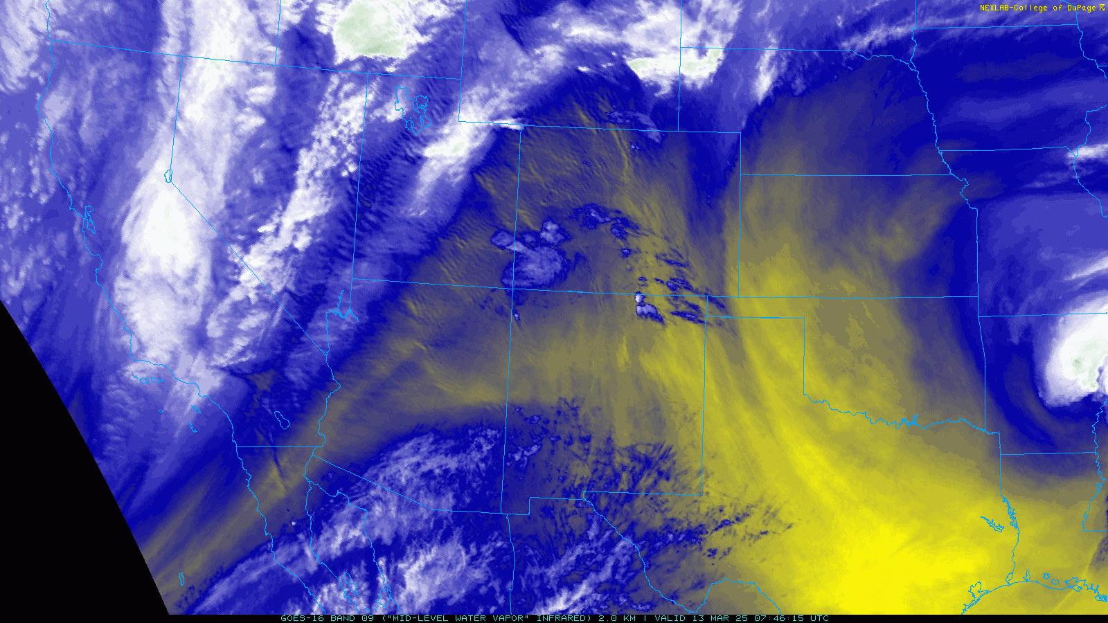
As of Thursday morning, a Pacific trough and associated jet streak, which together will eventually fuel explosive cyclogenesis across eastern Colorado on Friday, are moving ashore into California right now. Out ahead of this trough, flow has turned southwesterly across the southern Rockies with dry air noted throughout Colorado and a few wave clouds forming in the lee of the Rockies.
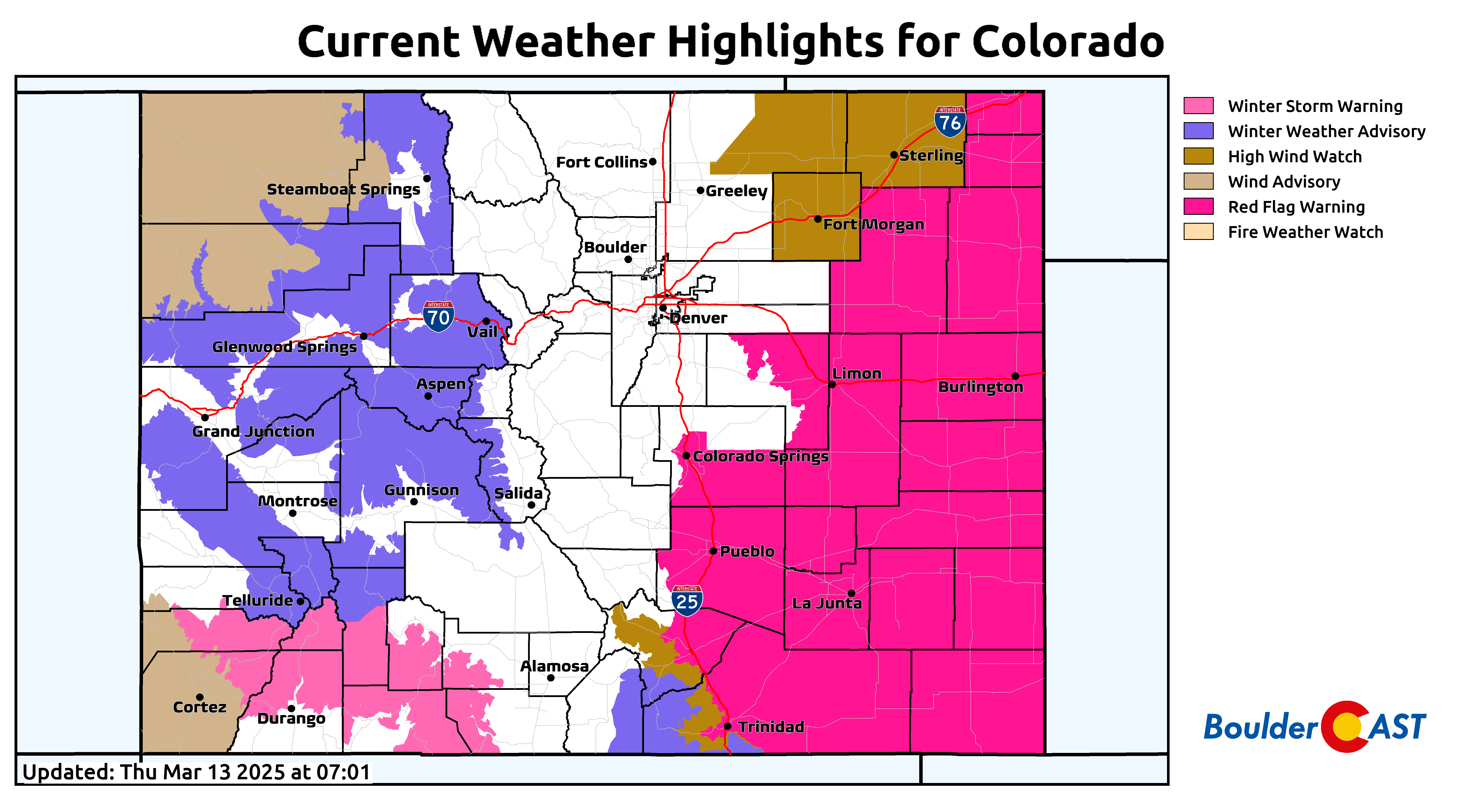
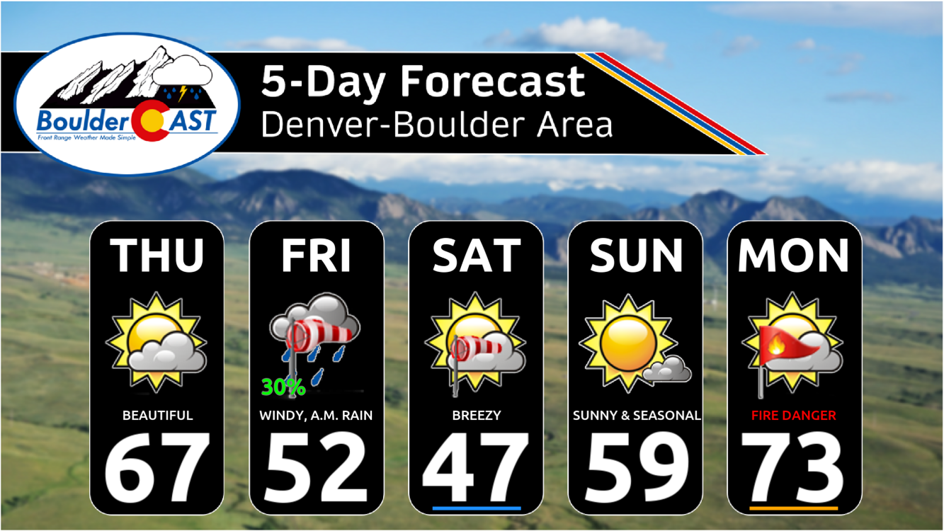
Warm temperatures in the 60s and 70s, combined with gusty southwest winds and the dry air, will lead to near-critical fire danger for much of southeast and far eastern Colorado on Thursday. Red Flag Warnings are posted for these areas through early evening.
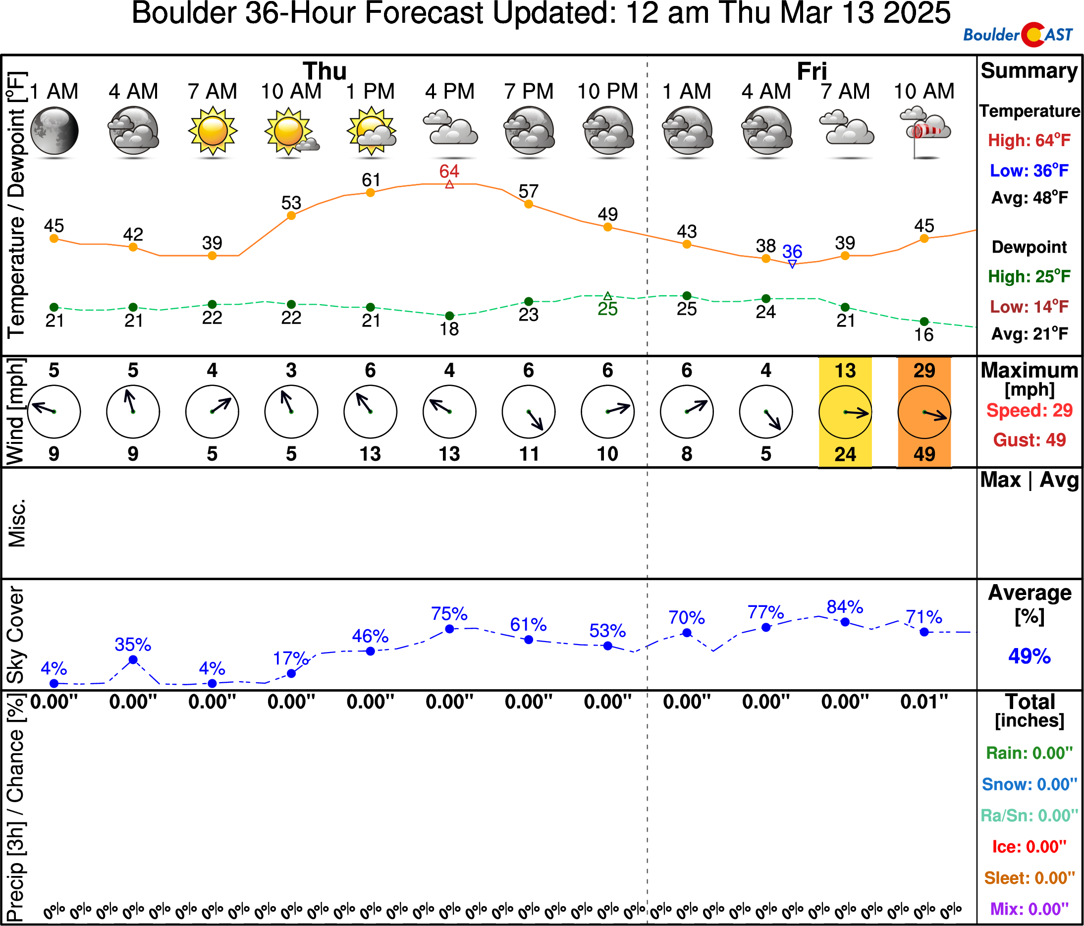
In Boulder and Denver, look for highs to reach the middle to upper 60s with light winds and increasing clouds.
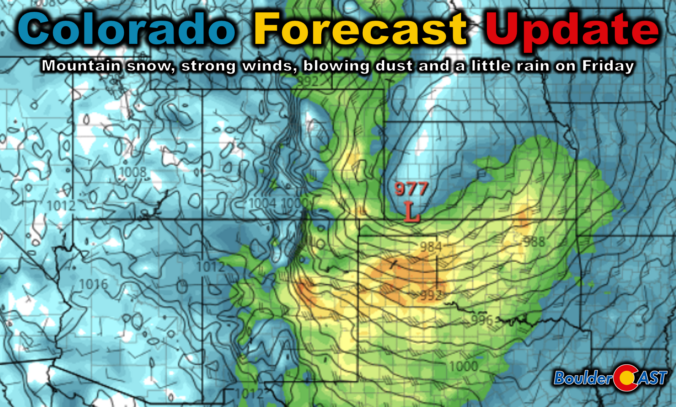
Look closely — the NowCAST forecast above hints at big changes brewing for tomorrow! As the broader storm comes across the Four Corners region late Thursday night into early Friday, explosive cyclogenesis will occur across eastern Colorado which will lie in the left exit region of a strong jet streak aloft. The 1000-millibar low pressure center will plummet down close to 975 millibars by Friday night! This would put this storm in close company with the infamous 2019 bomb cyclone which set the state record for lowest sea-level pressure exactly six years ago.
In response to this rapid pressure fall, winds will quickly increase across all of eastern Colorado and the surrounding states on Friday. The Euro model forecast animation below shows the developing surface low and its expansive wind field as it spawns and then races off towards the Great Lakes.
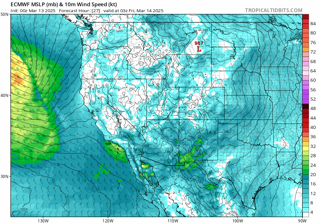
The strongest wind gusts, pushing over 55 MPH, are expected to occur well east of Denver into Kansas and Nebraska and eventually the Dakotas. Blowing dust and power outages are definitely a concern across the Plains of eastern Colorado.
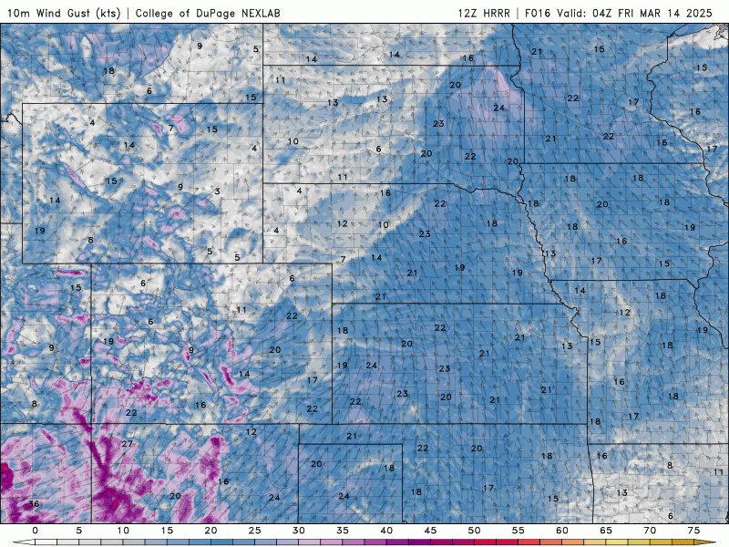
In the immediate Boulder-Denver area, peak wind gusts will be slightly tamer in the 30 to 50 MPH range during the day Friday, probably not enough to cause any real damage issues here, but the wind will certainly be heard and noticeable. Winds will start to weaken Friday evening and night as the storm ejects hurriedly into the Great Plains.

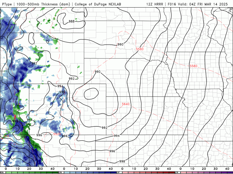
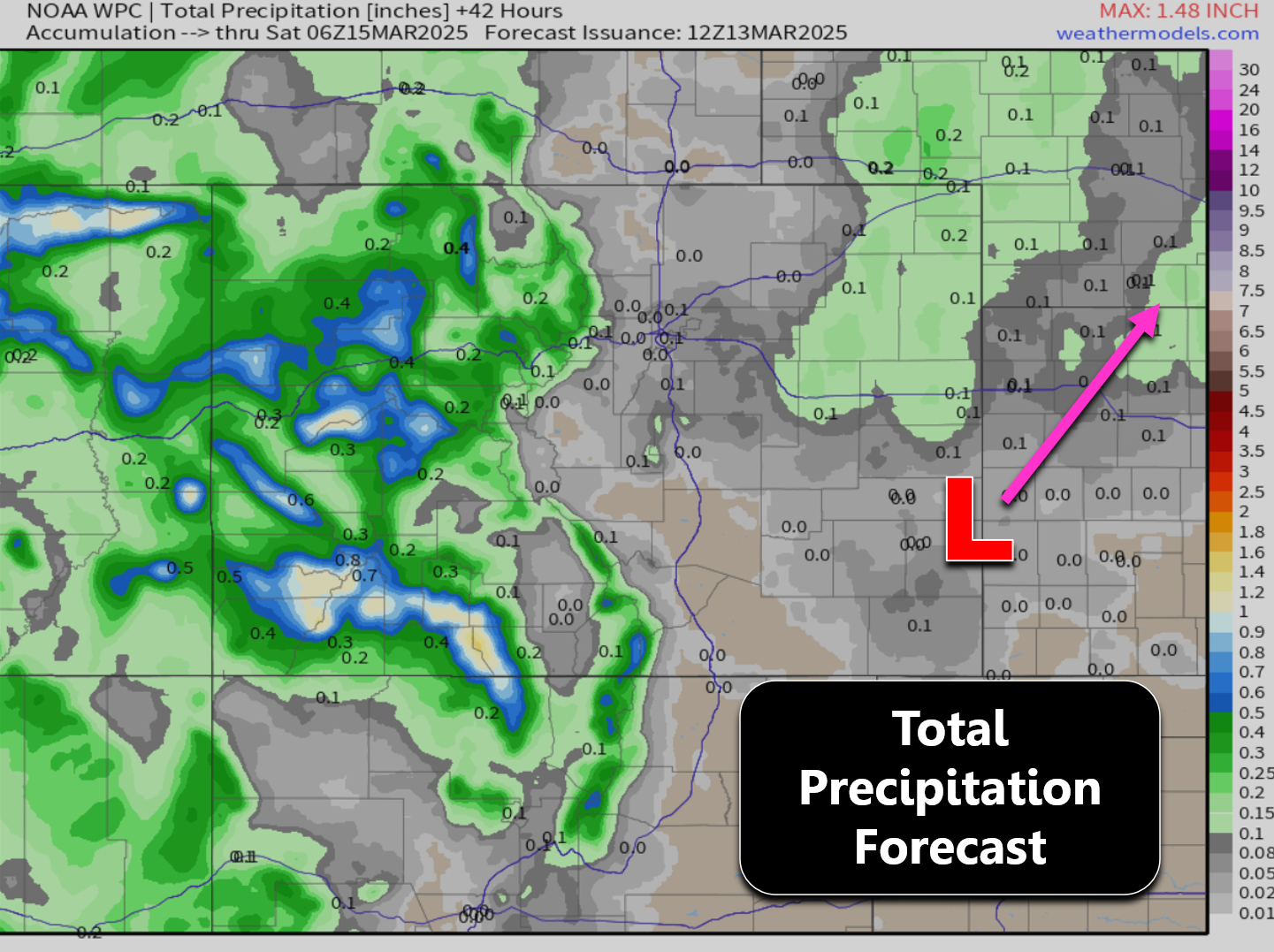
In addition to the intense winds, precipitation will develop on the backside of the vigorous surface low across much of eastern Colorado. There is some low-level dry air lurking around early on, and by the time the storm starts to pull in more moisture, it will already be vacating the area. Thus, we’re not expecting much actual precipitation across eastern Colorado at all, just scattered wind-whipped rain showers with snow along the Palmer Divide where it will be cold enough for that. The Boulder area really only has a very brief window for any raindrops at all Friday morning before winds quickly shift to downslope here. Based on the latest short-range guidance, Friday morning from 6AM to Noon is the window where short-lived light rainfall may occur.
Precipitation totals across eastern Colorado will be fairly light, with some spots on the eastern Plains possibly seeing up to 0.20″. The Denver Metro area is only looking at a “pavement wetting” or less. The lack of precipitation with this powerful but ultimately quick-moving storm is a double-edge sword. The dearth of snow means there won’t be blizzard conditions to worry about alongside the intense winds, which is good news of course, but the lack of precipitation altogether means widespread blowing dust may occur creating reduced visibility and air quality in areas of eastern Colorado that remain mostly dry.
The Mountains will see significant snow (and wind) from this big trough as it passes beginning Thursday night into Friday night. The central and northern ranges stand to receive 3 to 10 inches by Saturday morning, while the San Juans of southwest Colorado will receive double that! Expect winter driving conditions, significant traffic and possible road closures west along Interstate 70 and other mountain passes late Thursday night into early Saturday.
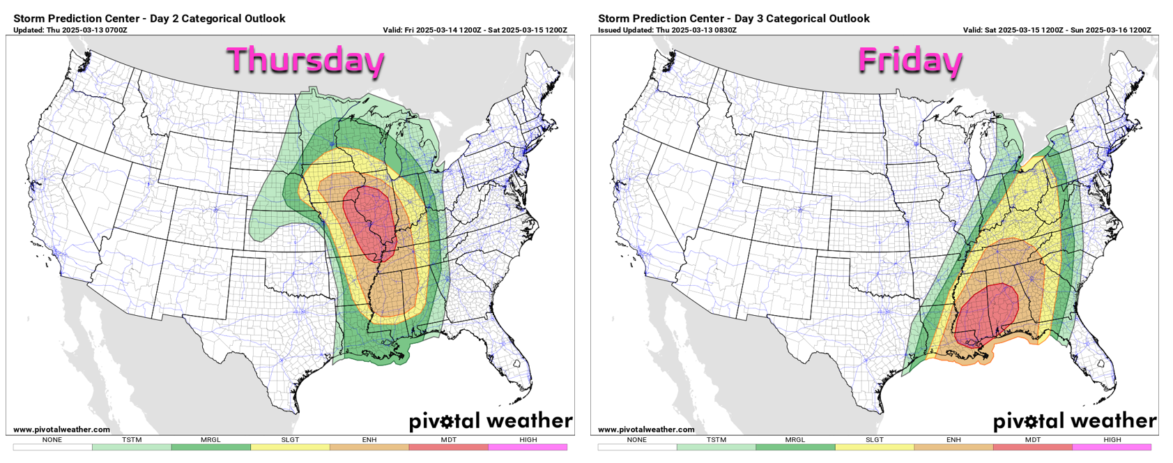
As the big storm heads east, it will create quite a mess across the entire nation, with winter weather in the Dakotas/Minnesota, but more concerningly, the first major tornado outbreak of 2025 is set to unfold in the warm sector of the storm. The NOAA Storm Prediction Center has already identified areas of Moderate Risk in their Day 2 (Thursday) and Day 3 (Friday) outlooks. This is very unusual and is a sign of just high the severe potential will be in the days ahead in the Midwest and Deep South.
Of course, we don’t have to worry about any severe weather just yet here in Colorado. Our extended outlook doesn’t look too bad — we just wish this impending storm would have delivered more precipitation and less wind. Breezy and cooler weather will linger into Saturday before we warm up and turn VERY nice heading into early next week. All signs point to Monday reaching the 70s with gusty winds returning and fire danger ramping up.
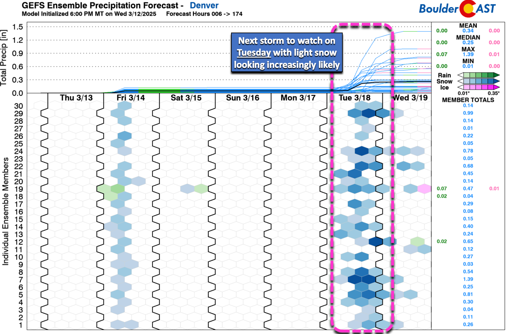
We’re already tracking our next storm system set to arrive around Tuesday, one which looks somewhat likely to deliver light snow to our area. Stay tuned and subscribed!
Get BoulderCAST updates delivered to your inbox:
Go Premium, get all the perks.
Daily Forecast Updates
Get our daily forecast discussion every morning delivered to your inbox.
All Our Model Data
Access to all our Colorado-centric high-resolution weather model graphics. Seriously — every one!
Ski & Hiking Forecasts
6-day forecasts for all the Colorado ski resorts, plus more than 120 hiking trails, including every 14er.
Smoke Forecasts
Wildfire smoke concentration predictions up to 72 hours into the future.
Exclusive Content
Weekend outlooks every Thursday, bonus storm updates, historical data and much more!
No Advertisements
Enjoy ad-free viewing on the entire site.
Enjoy our content? Give it a share:


You must be logged in to post a comment.