The Front Range will reside directly between two nearby storm systems Tuesday afternoon into Wednesday. Together they will provide a unique atmospheric setup favoring snowfall across mainly the Foothills, but also the western and southern Denver Metro area. Let’s take a look at the interesting setup, timing, and projected snowfall amounts.
At a Glance:
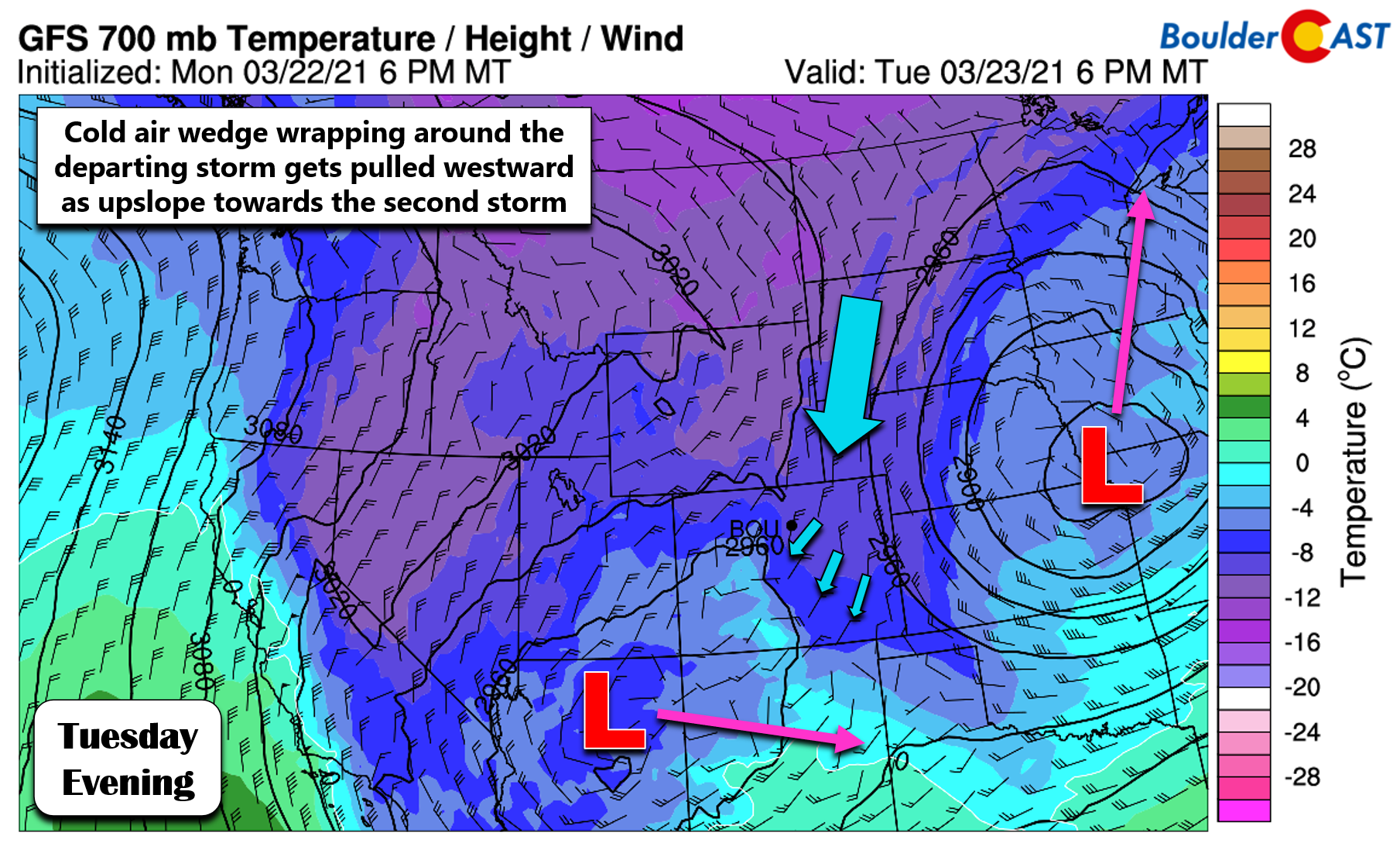
- The Front Range will be in a unique spot Tuesday into Wednesday, with cold air advection aloft from a departing storm overlapping with the large-scale lift and upslope from an approaching storm
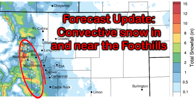
- Convective snow showers will develop Tuesday afternoon, mainly in the Foothills leading to pockets of moderate to heavy snow
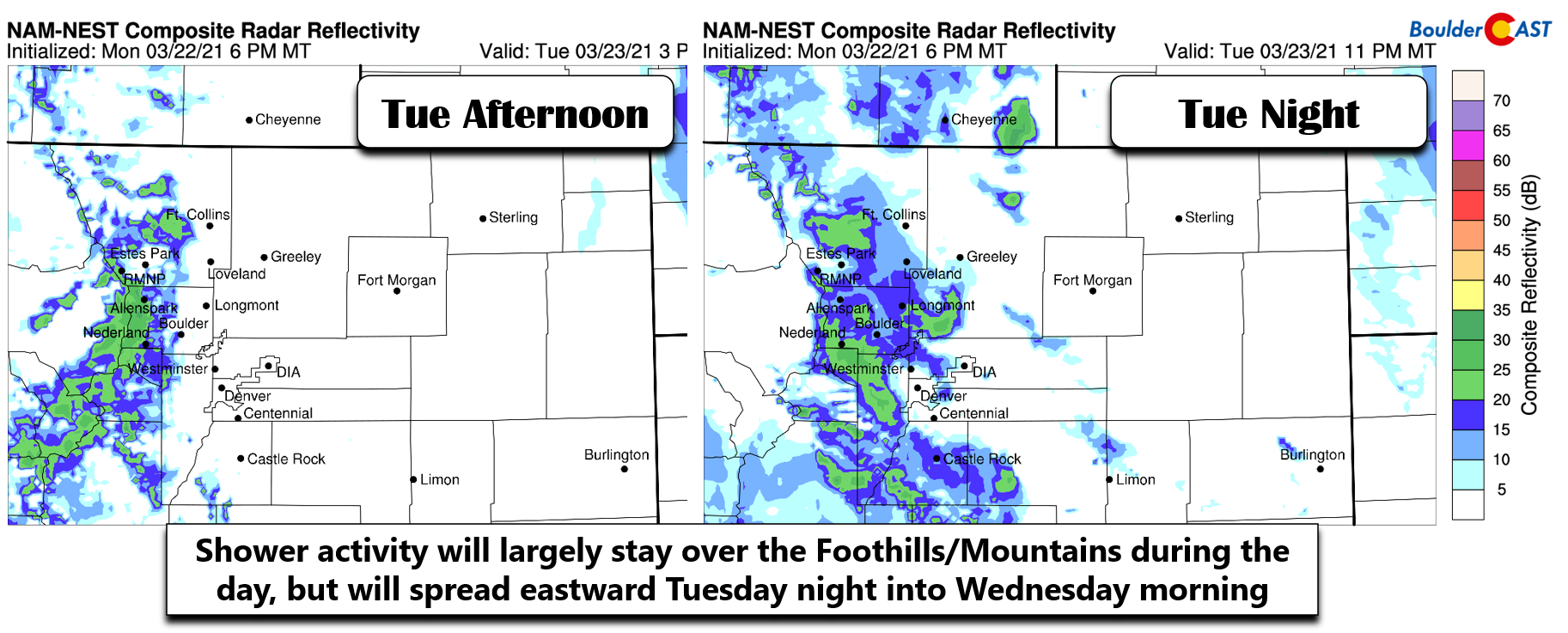
- Snow will spread eastward across the lower elevations later Tuesday night and linger into early Wednesday
- Snowfall amounts will be highest in the Foothills, but portions of the Denver Metro area will see snow too
Help support our team of Front Range weather bloggers by joining BoulderCAST Premium. We talk Boulder and Denver weather every single day. Sign up now to get access to our daily forecast discussions each morning, complete six-day skiing and hiking forecasts powered by machine learning, first-class access to all our Colorado-centric high-resolution weather graphics, bonus storm updates and much more! Or not, we just appreciate your readership!

F
irst, we want to pass along our deepest condolences to those affected by Monday’s preventable act of violence in Boulder. This one strikes way too close to home for us. Like many of you, we haven’t fully processed the situation or our emotions yet and remain completely in shock. There is no doubt that a dark cloud will linger over our little city for a long time to come following this tragedy. Be safe and take care of one another.
The atmospheric setup today and tonight is an interesting one as Colorado will rest directly between two storm systems and will thus feel slight effects from both at the same time. The larger and departing storm is located in the Great Plains right now. This is the system that brought us the snow Sunday evening and night. On the backside of this low pressure, strong northerly flow is wrapping cold air and some moisture back southward into eastern Colorado aloft, as shown below. The second and weaker storm is positioned in Arizona, but the pressure falls are causing that cold wedge to turn slightly westward and become upslope for the Front Range. This places the Denver Metro area in a unique spot meteorologically speaking, with cold air advection aloft from a departing storm overlapping with the large-scale lift/upslope from an approaching storm. The setup isn’t perfect, however, as the track of the Arizona low is quite far south.
Nonetheless, the ingredients will come together this afternoon into Wednesday morning for snow to form across the Front Range, fueled largely by instability created from the cold air aloft and the upslope in the atmosphere. During the day Tuesday, most of the activity will remain across the Mountains and Foothills. This is because of the deep upslope, which will be pushing the convective cells westward as they form. However, as we head into Tuesday night and the Arizona low draws closer, we will see snow spread eastward across the lower elevations as well. The high-resolution NAM model simulated radar forecasts below show this eastward expansion Tuesday night, from a primarily Foothills affair to one encompassing much of the Denver Metro area.
The high-resolution HRRR model shows a similar setup as well. The precipitation forecast animation below runs through Wednesday morning. The focus is clearly across the higher terrain, but the western and southern Denver Metro area will likely get in on the action as well later on Tuesday night.
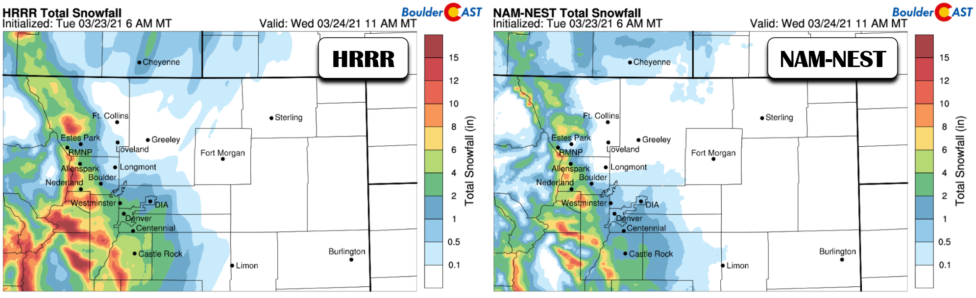
The greatest potential for sizable accumulations with this setup will be across the Mountains near the Continental Divide and into the higher Foothills where upwards of 7″ of snow could fall by late Wednesday morning. Given the setup, it wouldn’t be surprising to see a few localized 8 to 12″ totals mixed in. Below is what two high-resolution models are predicting for snow amounts. Notice that the southern and western Metro area stand the best chance to see a couple inches of accumulation, with little to no snow predicted across the northeast side of town. This follows the trend of the upslope and thus the direction that the developing snowfall will be shepherded.
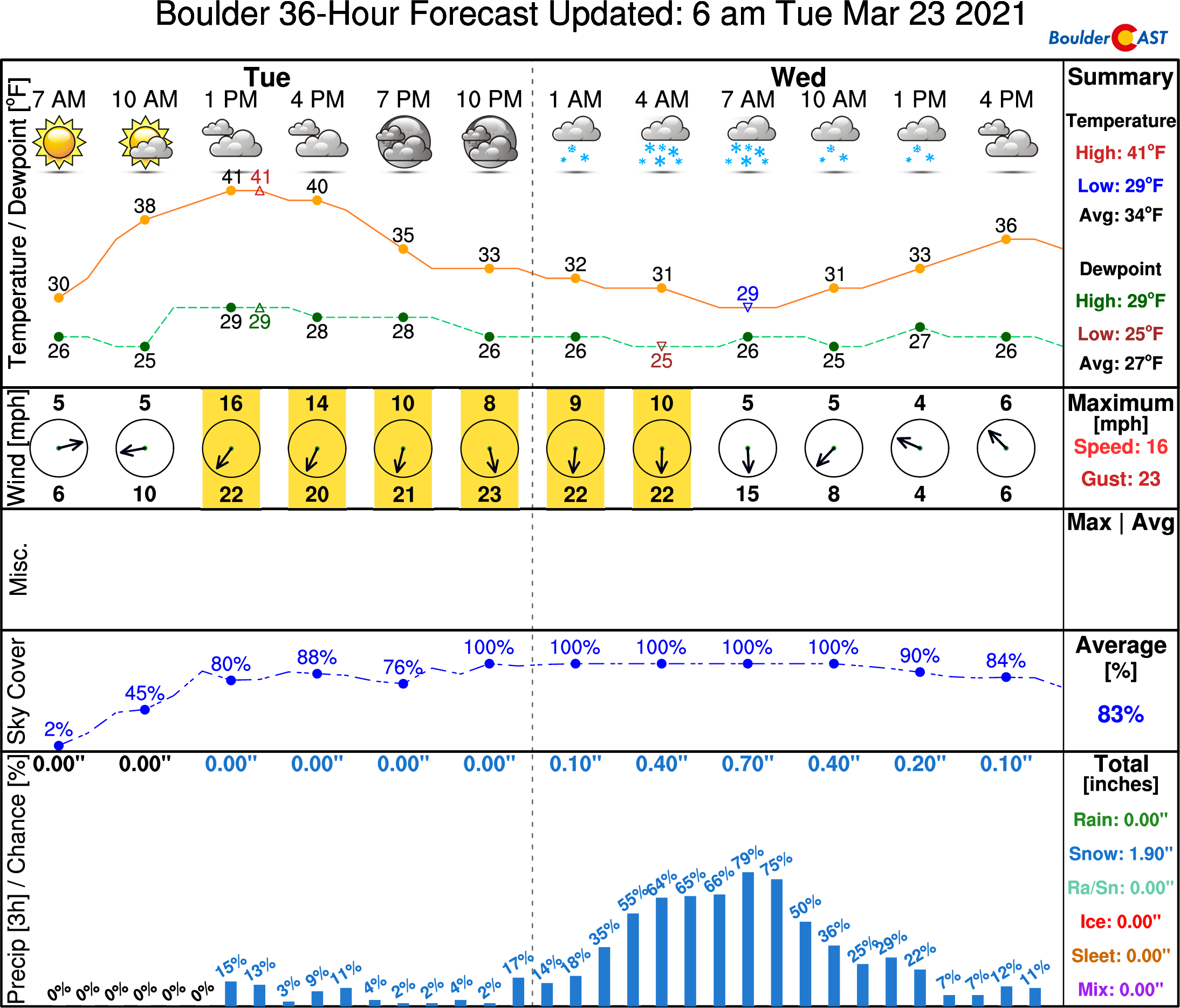
Our NowCAST for Boulder has the best chance of accumulating snow occurring during the overnight period through Wednesday morning with around 2″ of snow predicted. Also note that temperatures will fall into the 20’s overnight so there could be some very minor impacts on the morning commute, but overall most areas should be just fine.
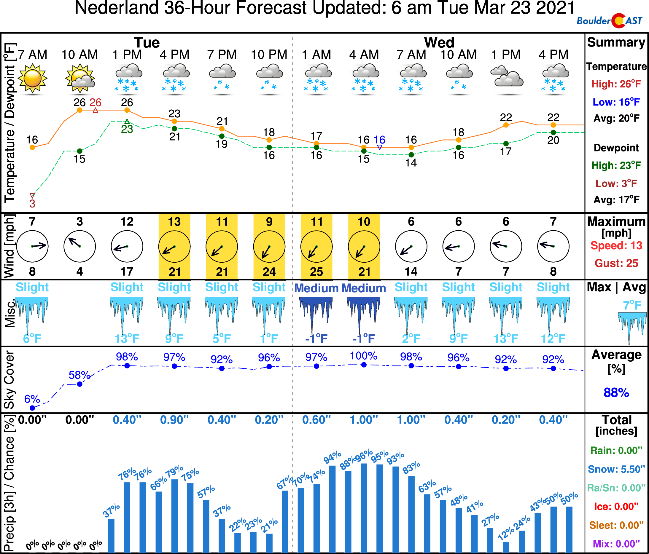
However, just 15 miles to the west in Nederland (~8500 feet elevation) there will be snow around much of the day Tuesday, Tuesday night, and a large part of Wednesday, with 5 or 6″ of snow indicated.
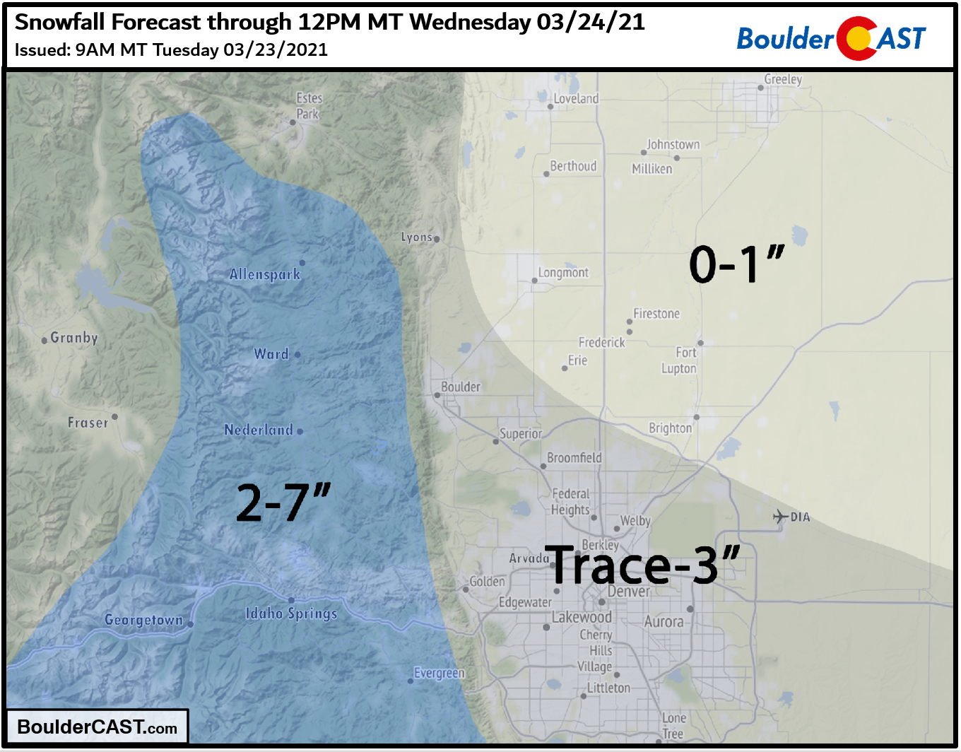
All things considered, this will be more of a “popcorn”, spotty event than usual, especially Tuesday afternoon and evening in the Foothills. Tuesday night into Wednesday the action should become more widespread and include the lower elevations. Our snowfall forecast map for this event is shown below and covers snow falling through mid-day Wednesday. We’re expecting the most snow in the higher terrain of Boulder and Jefferson Counties. The best chance of accumulation across the lower elevations, up to 3″, will be in the western and southern suburbs.
As with any snowfall event containing small-scale convective elements, there is always going to be a larger amount of spatial variability. Some areas may see no snow at all, while others could surpass our forecast. If you recall, a scenario similar to this surprisingly dumped up to 9″ of snow in Boulder overnight about a month ago.
The forecast will remain unsettled and cooler than normal the rest of the week into the weekend with daily chances for precipitation but little in the way of snowfall accumulation outside of the higher terrain.
Subscribe to get notified instantly when our forecast updates go live:
We respect your privacy. You can unsubscribe at any time.
Help support BoulderCAST
Help support our team of Front Range weather bloggers by joining BoulderCAST Premium. We talk Boulder and Denver weather every single day. Sign up now to get access to our daily forecast discussions each morning, complete six-day skiing and hiking forecasts powered by machine learning, first-class access to all our Colorado-centric high-resolution weather graphics, bonus storm updates and much more! Or not, we just appreciate your readership!
Share the best forecast:
.


You must be logged in to post a comment.