A stark change in our weather is set to take hold for Friday as we move from seemingly never-ending summer heat to a much cooler and rainy setup that will bring with it a significant flood risk to the Front Range. The remnants of Tropical Storm Harold and a strong Canadian cold front will align almost perfectly over the area late Friday into Saturday with more than 1″ of rainfall possible and even more locally. In this update we discuss the latest timing of everything, the temperature nose dive, rainfall amounts, and which areas are at greatest risk to see flooding.
We discuss Boulder and Denver weather every single day on BoulderCAST Premium. Sign up today to get access to our daily forecast discussions every morning, complete six-day skiing and hiking forecasts powered by machine learning, access to all our Front Range specific weather models (including smoke forecasts), additional storm updates and much more!
Daily Forecast Updates
Get our daily forecast discussion every morning delivered to your inbox.
All Our Model Data
Access to all our Colorado-centric high-resolution weather model graphics. Seriously — every one!
Ski & Hiking Forecasts
6-day forecasts for all the Colorado ski resorts, plus more than 120 hiking trails, including every 14er.
Smoke Forecasts
Wildfire smoke concentration predictions up to 72 hours into the future.
Exclusive Content
Weekend outlooks every Thursday, bonus storm updates, historical data and much more!
No Advertisements
Enjoy ad-free viewing on the entire site.
The “perfect storm”, well almost
As we alerted you to way back on Monday in our weekly outlook, things are shaping up to be interesting across the Front Range as numerous ingredients for heavy rainfall come together Friday into Saturday in what can somewhat accurately be described as a “perfect storm” type of scenario! What a great movie by the way….
The two primary ingredients we have been tracking this week that will contribute to the impending flood risk…
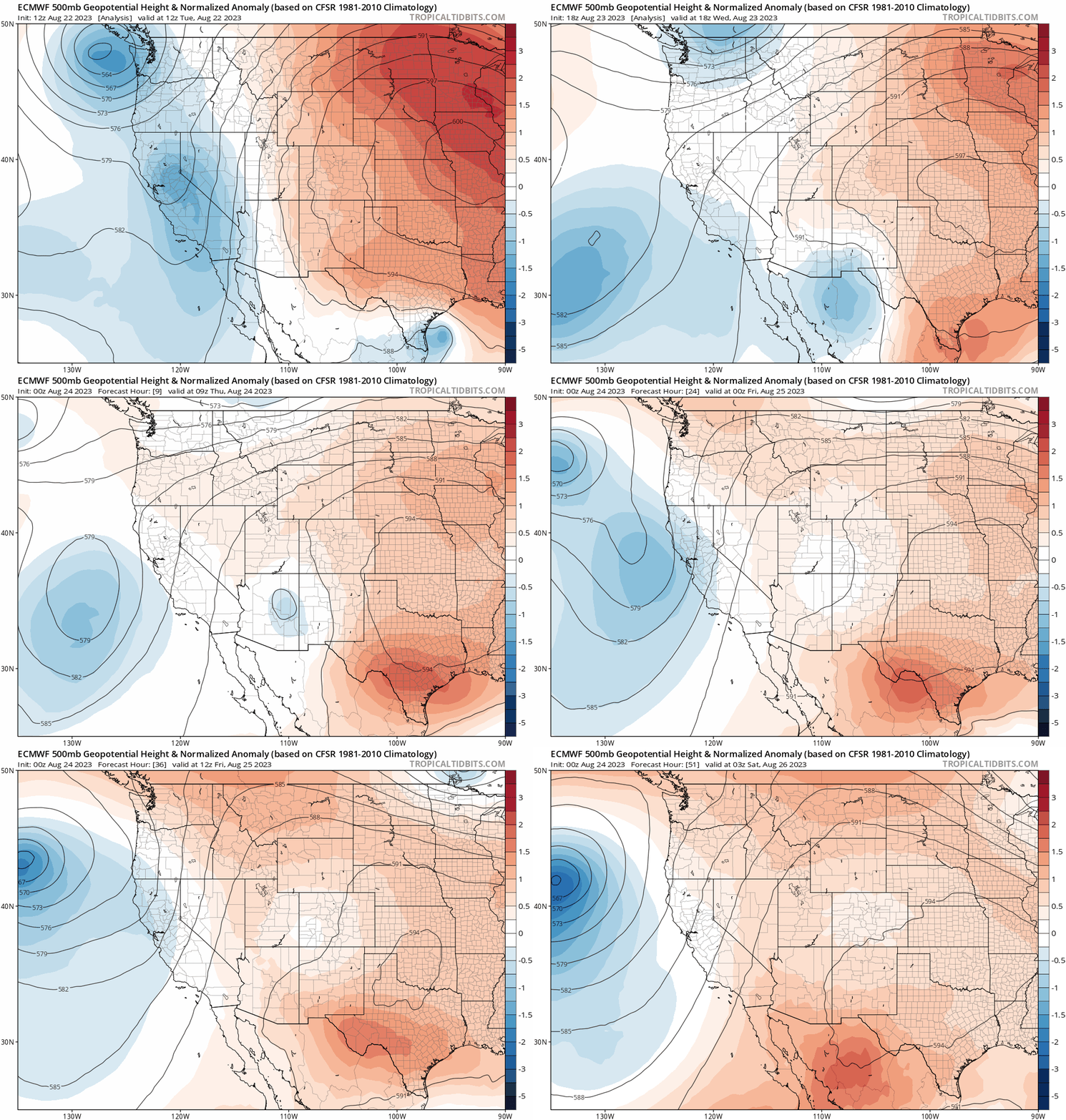
1 ) The remnants of once Tropical Storm Harold which made landfall in far south Texas a few days ago will be pushing into our area on Friday, wrapping around the southwestern periphery of a colossal high pressure system in the center of the country. This anomalous high pressure center, combined with a stationary trough along the West Coast, are acting to “funnel” the juicy tropically-infused remnants of Harold towards Colorado after first sweeping through the Four Corners. Most of the moisture from Harold is higher up in the atmosphere, as opposed to near the surface, but overall it will contribute to the heavy rainfall potential from this event. The deep southerly flow in general will also entrain additional moisture from the more subtropical areas to our south — something akin to a super monsoonal surge.
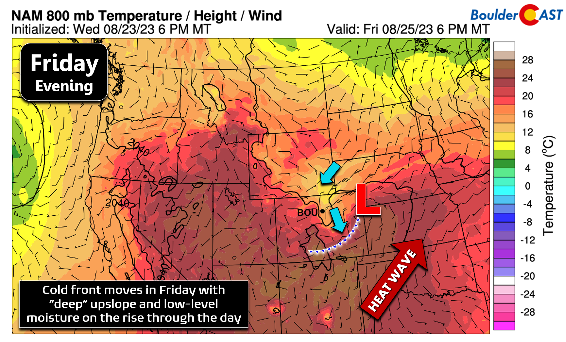
2 ) After a long slog of 90-degree days in the Metro area — Thursday will be the 10th in a row for many — a strong cold front will drop southward across the region on Friday and get reinforced through the day by developing low pressure in far eastern Colorado.
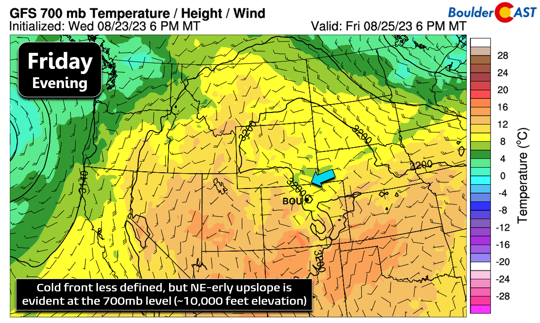
The upslope behind this cold front is impressive for August as the signature will reach up to and even beyond 700mb (~10,000 feet elevation). The winds aloft slamming into the terrain Friday evening won’t be all that strong, but 10 to 15 MPH upslope is never going to hurt our chances of rain during an event like this!
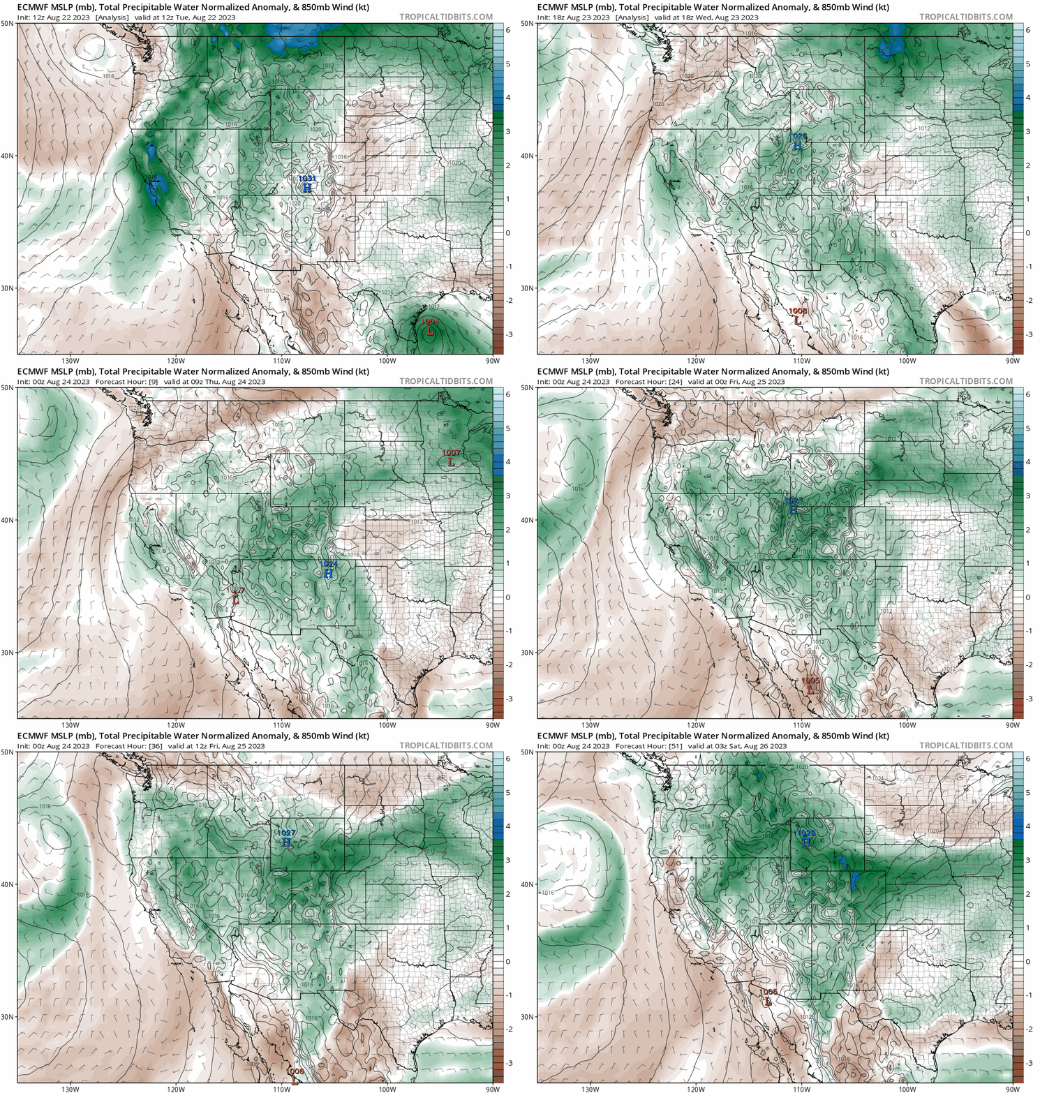
As a result of the cold front and the left-overs of Harold, moisture will be through the roof on Friday across the Front Range. You can sort of see the two ingredients merging in the European model’s precipitable water (moisture) anomaly forecast animation below.
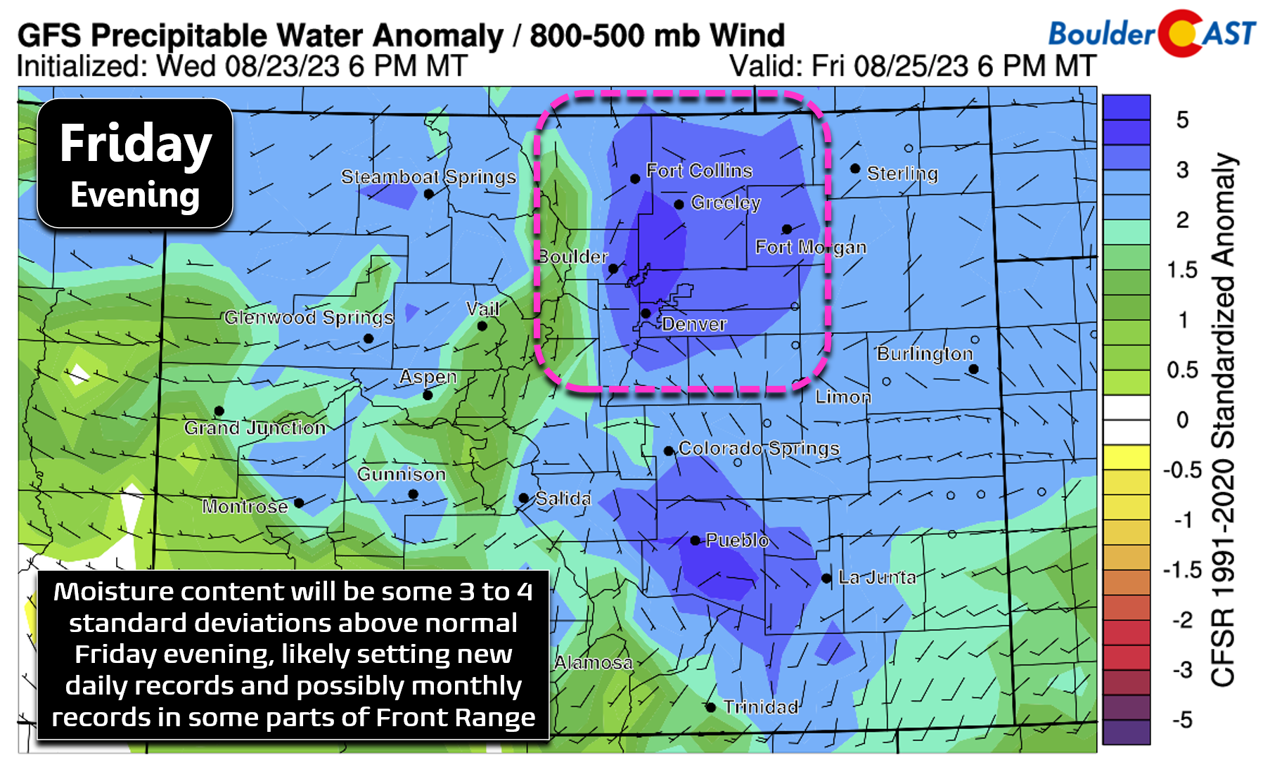
Precipitable water is forecast to climb close to 1.5″ in our area Friday evening, likely shattering all-time daily record highs all around. This much moisture so late in August is exceptionally rare — we can’t stress that aspect of this event enough!
To put this into perspective, the September 2013 Colorado Flood saw precipitable water climb to around 1.35″ over Boulder and Denver, obliterating existing moisture records for the month and shockingly it persisted at or above those existing record levels for roughly four straight days!

A time series of precipitable water for the duration of the 2013 Flood. The green line denotes the previous record moisture for the month of September. Moisture levels in Boulder were above the all-time max for almost four straight days!
Yes there will be record moisture in place across eastern Colorado on Friday, but moisture is only one component needed for torrential rainfall. In order to produce the goods, a mechanism is also needed to lift the moisture to cool the air and condense the water vapor. Friday will be mostly overcast through the day with cold air advection ongoing at the low-levels behind the cold front — two factors that will inhibit lift in the atmosphere via stabilization. However, the passage of the shortwave energy from remnant-Harold and the upslope will be counter-acting things. Plus we are seeing a small amount of instability in the model soundings. Moisture will indeed be off the charts, but the equally important ingredient lift will only be modest across our area at best. Thus we are not expecting the type of disastrous flooding that occurred in 2013. This will also be a much shorter duration event which will limit the impacts as well.
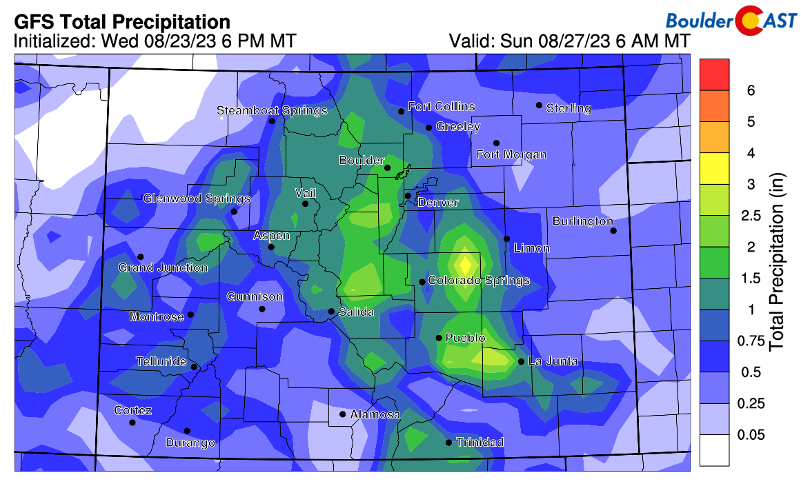
The GFS model has recently backed off of this event somewhat, but still shows a solid dump of precipitation for much of the state in the coming days. The Boulder-Denver area is set to see around 1″ of rainfall according to this model. Keep in mind this particular forecast graphic below includes all rain from Thursday through Saturday. The main event is really Friday evening.
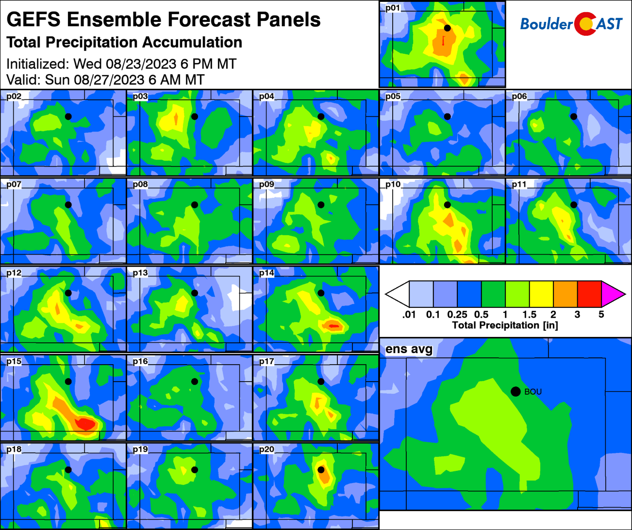
The GFS ensembles show a slight southern bias with the bullseye of heaviest precipitation — perhaps closer to the Springs and Pueblo rather than Denver. This does not seem well justified in our opinion. The heaviest rainfall is more likely to be over the Front Range given the upslope direction and positioning behind the front.
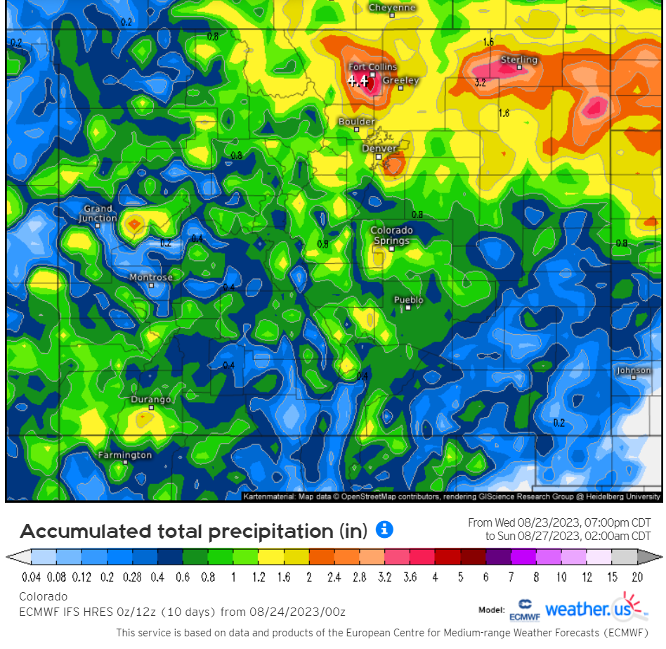
Please do not underestimate this impending rainfall event. Model support is strong for our entire area to see between 0.5 and 1.5″ of rainfall by Saturday night, with locally higher totals all but guaranteed. Some models like the Euro predict that more widespread high-end totals of 2 or even 3″ may be possible. Rainfall could be spotty at times, but with so much moisture in-play the threat of embedded torrential rainfall will be high — and thus so too will be the flood risk.
The most at-risk area right now appears to be in and near the Foothills of Boulder and Larimer Counties. However, we expect the entire Front Range will be served a Flash Flood Watch shortly in preparation for an active Friday and Friday night of showers and thunderstorms capable of torrential rainfall.
⚠️ Flood Watch posted! It's effect from Friday AM to Saturday AM for the Front Range 🌊
Still this isn't a true upslope storm — there will be winners & losers due to the scattered nature of the t-storms. The ones that hit will hit HARD though over the next 36 hours! #COwx pic.twitter.com/ZPFkPbxRbU
— BoulderCAST Weather (@BoulderCAST) August 24, 2023
Here’s the latest expected timeline for the event:
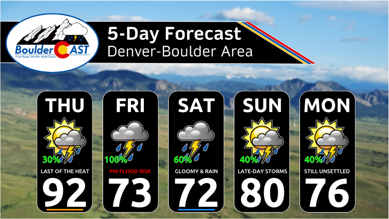
- Thursday: One last final day climbing into the 90s, the 10th in a row for most cities! Mostly sunny early but with bubbling storm clouds in the late afternoon. Most of the action remains across the higher terrain, but we do expect some storms to spill into the western Metro area. Chance of storms is about 30% around Boulder, but only 10% to the east.
- Friday: Overcast skies prevail through the day with much cooler weather. High temperatures likely remain below 75° for the entire area, maybe even below 70° — what a relief from those endless 90s! Scattered showers and storms begin to develop by midday, mainly across the higher terrain. They will spread eastward though, becoming fairly widespread through the evening hours as everything comes together right over the Metro area. Any of these storms could put down more than 1.5″ of rainfall in an hour. No severe weather is expected due to the extensive cloud cover and limited instability.
- Friday night: Rain will be the most widespread and heavy before midnight, but likely some showers and storms continue through the overnight and to sunrise.
- Saturday: Some morning showers possible, then a break in the action during the day. Storms reform in the daytime heating moving off the higher terrain by late afternoon and evening. Locally heavy rain is possible with these storms as well, but it should not pose a widespread flood risk like Friday. Highs on Saturday will only be in the 70s as well.
- Sunday and beyond: Things return to business as usual. Moisture continues to decrease and temperatures rebound towards 80 degrees or better. Storms will remain though in some form, though more of the typical scattered variety.
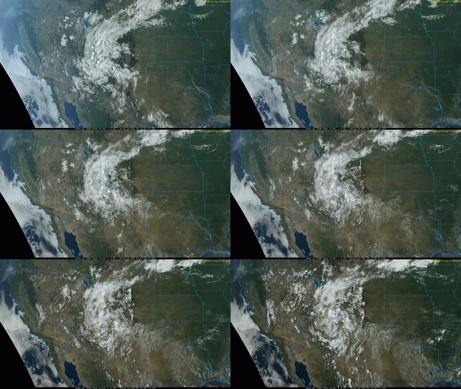
The remnant low pressure from Tropical Storm Harold spinning across northeast Arizona on Thursday. This will be heading slowly into Colorado over the next 24 hours.
That’s all for now. Definitely plan on staying weather aware Friday afternoon through Saturday morning. We’re not expecting exceptional impacts, but the flood risk is certainly real with this nearly “perfect storm” scenario across the Front Range. Burn scars will be particularly at risk. Stay safe and enjoy the rapid plunge into cooler and wetter weather ahead!
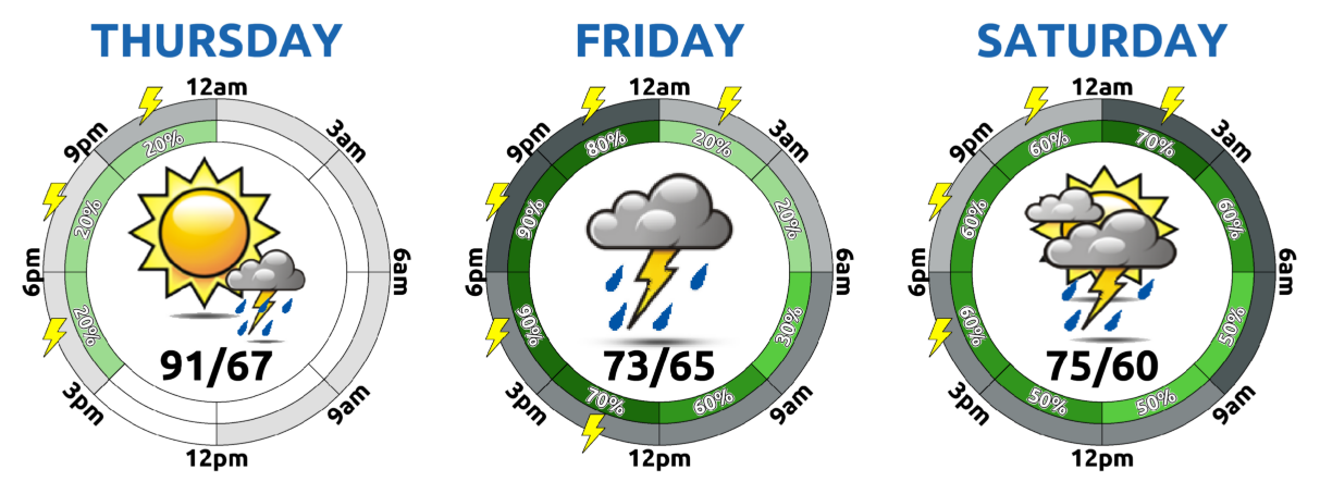
Legend: Clockwise around the circle represents the 24 hours in the calendar day. The gray outside ring is cloud coverage (dark is more), the inner green ring is rainfall (darker is better chance) and lightning bolts mean lightning risk (duh!).
MONSOON SPECIAL: Through the end of July, use promo code MONSOON to save 25% on BoulderCAST Premium. Redeem this time-limited offer HERE.
Daily Forecast Updates
Get our daily forecast discussion every morning delivered to your inbox.
All Our Model Data
Access to all our Colorado-centric high-resolution weather model graphics. Seriously — every one!
Ski & Hiking Forecasts
6-day forecasts for all the Colorado ski resorts, plus more than 120 hiking trails, including every 14er.
Smoke Forecasts
Wildfire smoke concentration predictions up to 72 hours into the future.
Exclusive Content
Weekend outlooks every Thursday, bonus storm updates, historical data and much more!
No Advertisements
Enjoy ad-free viewing on the entire site.
Get BoulderCAST updates delivered to your inbox:
Enjoy our content? Give it a share!




You must be logged in to post a comment.