The week commences on the hot and dry side as a very strong and anomalous ridge over the central United States keeps much of Colorado locked into a scorching heatwave. Remnants from a tropical cyclone over the western Gulf of Mexico may influence our region later in the week as it interacts with a southward moving cold front. This should favor cooler temperatures and increasing chances for thunderstorms by the latter part of the week into the weekend. Read on for all the details of yet another semi-active weather week for us.
This week’s highlights include:
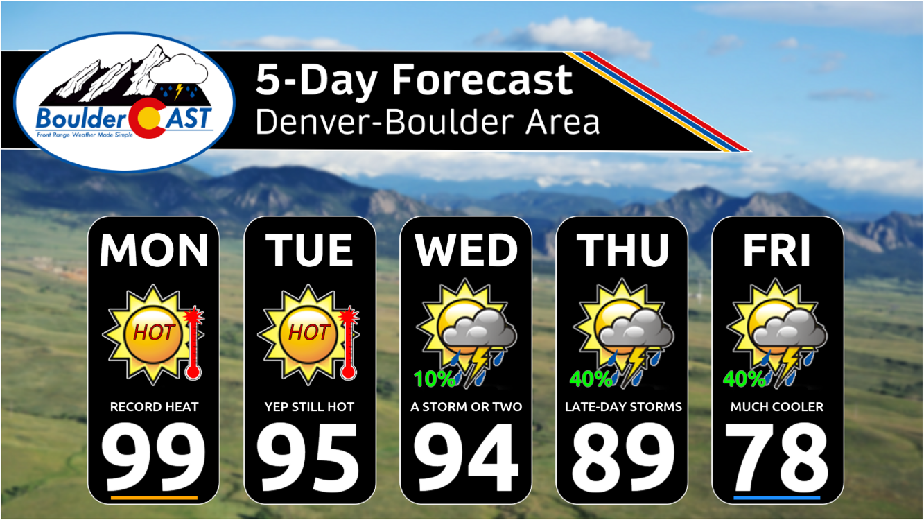
- An anomalous ridge over the central United States promotes continued hot weather in the Front Range early on
- Mid to upper 90s are expected the first three days of the week which will encroach on record highs
- Wet weather and cooler temperatures are favored for the late-week period
- Moisture increases from a cold front and possible tropical cyclone remnants resulting in our best storm chances coming Thursday and Friday
- Temperatures fall back into the 70s Friday following the passage of a cold front
DISCLAIMER: This weekly outlook forecast is created Monday morning and covers the entire upcoming week. Accuracy will decrease as the week progresses as this post is NOT updated. To receive daily updated forecasts from our team, among many other perks, subscribe to BoulderCAST Premium.

Go Premium, get all the perks.
Daily Forecast Updates
Get our daily forecast discussion every morning delivered to your inbox.
All Our Model Data
Access to all our Colorado-centric high-resolution weather model graphics. Seriously — every one!
Ski & Hiking Forecasts
6-day forecasts for all the Colorado ski resorts, plus more than 120 hiking trails, including every 14er.
Smoke Forecasts
Wildfire smoke concentration predictions up to 72 hours into the future.
Exclusive Content
Weekend outlooks every Thursday, bonus storm updates, historical data and much more!
No Advertisements
Enjoy ad-free viewing on the entire site.
Challenging record highs early in the week
You may of heard of a lot of things with the weather this past weekend, including the very hot and anomalous ridge parked over the central US promoting extreme heat and abundant excessive heat warnings across the Midwest into the Southern Plains. You may have also heard of the increasingly active tropics, both over the Pacific and the Atlantic Basins. Hilary made landfall just south of California on Sunday and has brought intense rains and strong wind gusts over California and Nevada. Additional rain will be felt into the Pacific Northwest and Montana today into midweek. The remnants of Hilary will not impact us here in Colorado as the ridge keeps everything well to our west. However a secondary tropical system, currently churning over the western Gulf of Mexico, may become a tropical storm or hurricane later Monday as it slowly moves westward toward the southern tip of Texas. This tropical system may be a player for us in the latter part of the week — more on that later…
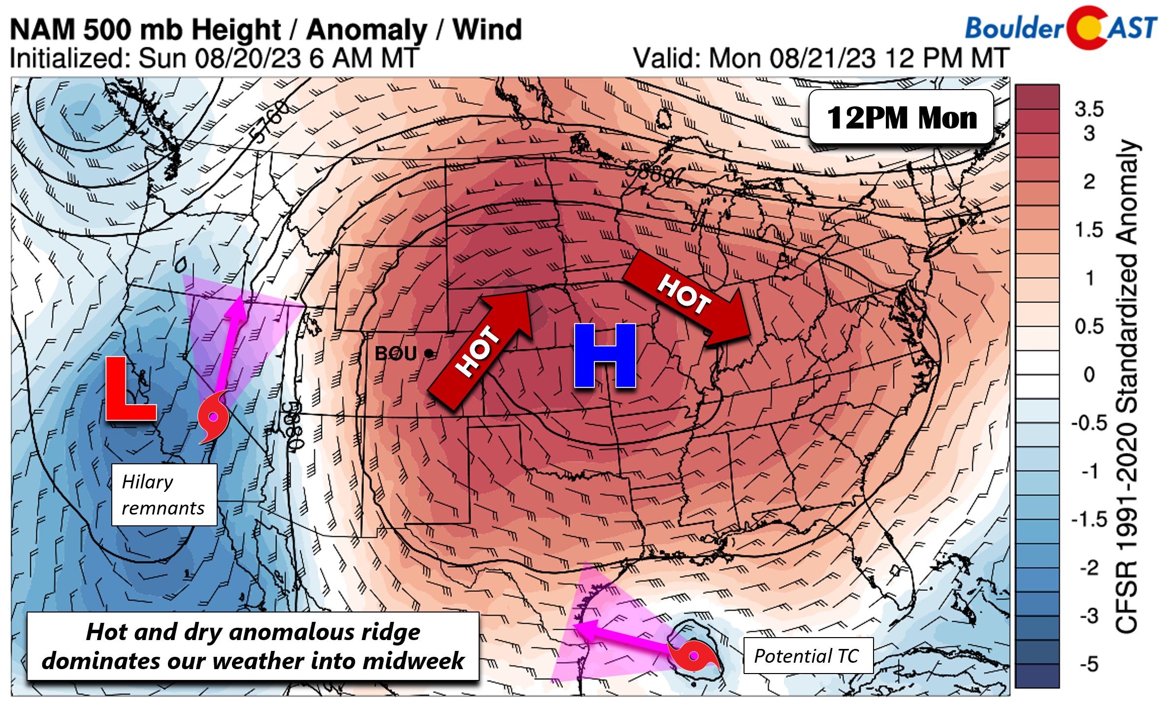
With the ridge to our east, dry weather will be promoted over much of Colorado to start the week. The deepest moisture will reside over the West Coast into Montana, tied mostly to the tropically-infused remnants of Hurricane Hilary.

The lack of rain Monday and Tuesday under the ridge will lead to temperatures in the upper 90s across the lower elevations. Skies will be mostly sunny as well making for an even hotter feel to the scorching heat. Fire danger will be slightly elevated both Monday and Tuesday as well with Red Flag Warnings posted along and east of Interstate 25 (though the wind criteria is marginal at best).
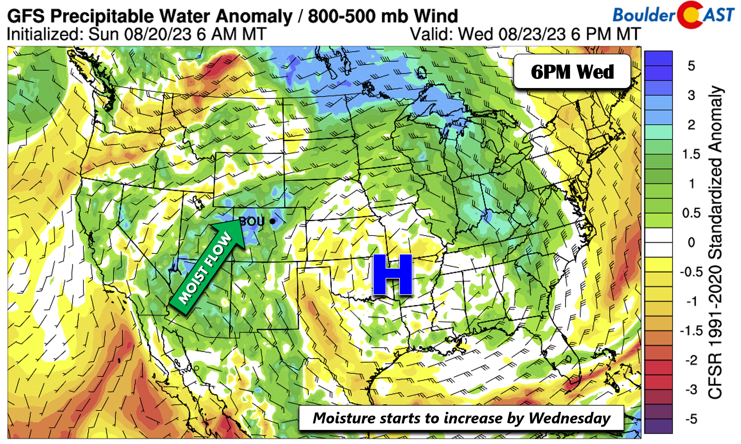
The precipitation/pressure plot below shows more clearly the potential tropical cyclone across the western Gulf Monday night.

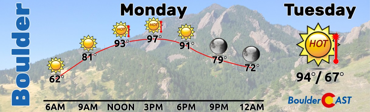
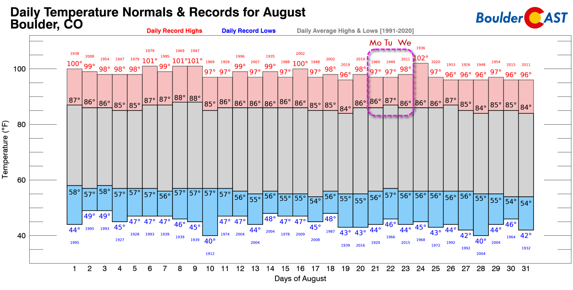
With temperatures reaching the upper 90s, Monday is likely to tie or break record highs in many Front Range cities. Both Boulder (shown below) and Denver have an existing record high for August 21st of 97°F set back in 1960. This value should easily be challenged on Monday. Tuesday’s record high is also 97°F in Boulder, and while still possible, it’s less likely to be eclipsed as temperatures are forecast to cool a degree or two for us.
The GEFS temperature forecast below shows the hottest days this week will likely be Monday and Tuesday, after which a cooling trend is favored Wednesday into Friday.

We mentioned the disturbance in the western Gulf just a bit earlier. However, this is not the only active system in the Atlantic Basin. The tropics in the Atlantic have become very active in the last several days. There are currently 5 systems of note from the Hurricane Center. Tropical Storm Franklin in the Caribbean, Tropical Storm Gert a bit further east, Tropical Storm Emily even further east than that and finally a potential system which just came off of Africa. The tropics have turned active right on time climatologically. Most of these systems are not anticipated to reach the United States mainland except for the disturbance in the Gulf of Mexico.

Wetter and “cooler” to end
Come Wednesday into Friday, the hot and dry weather is forecast to transition cooler and more unsettled, as suggested by every major model and as shown in the GEFS ensemble (below). Notice the uptick in ensemble members showing the better chances of showers/storms Thursday, Friday and into the weekend. Let’s discuss what this is tied to, which you may already know based on what you read a bit earlier.

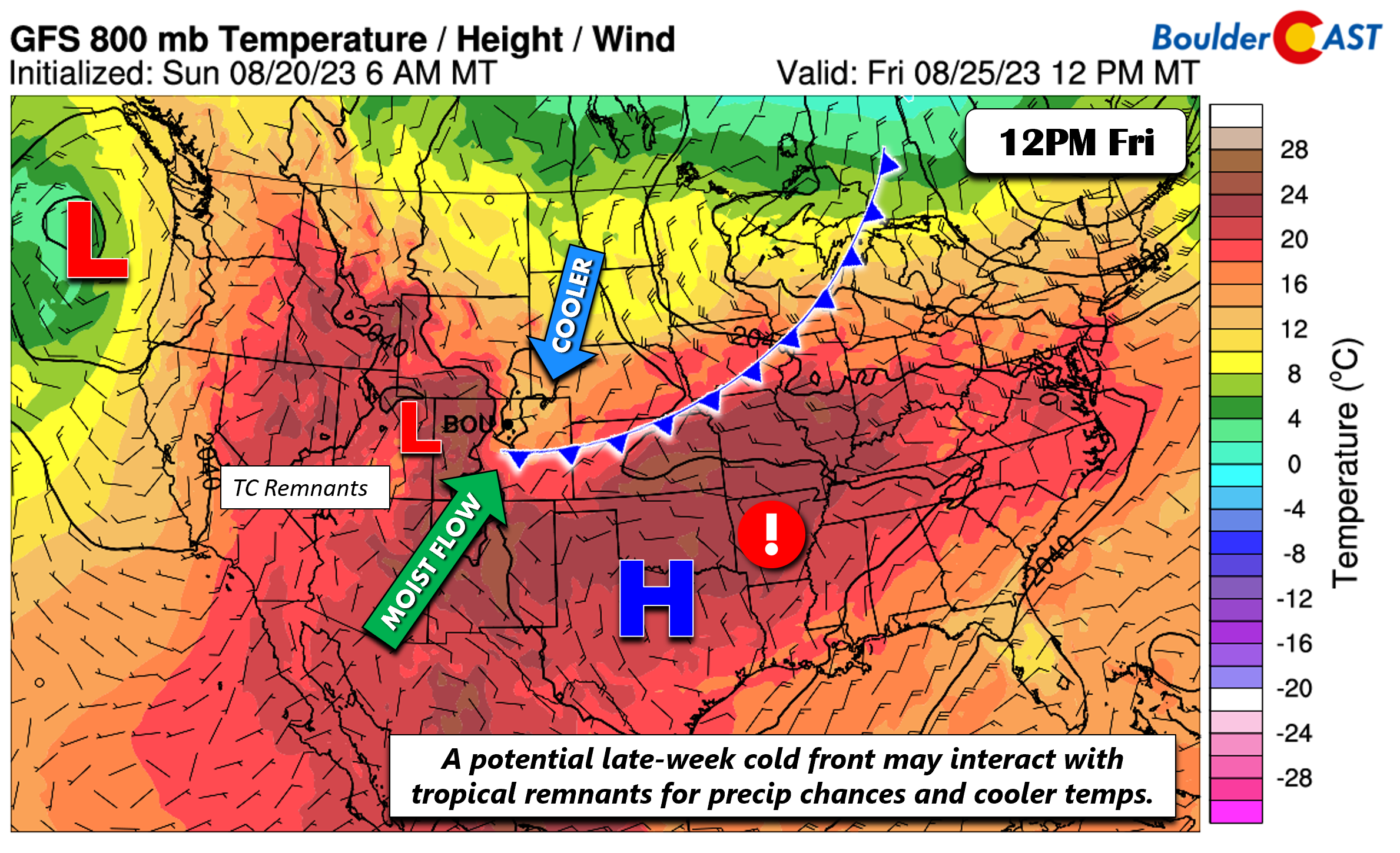
For one thing, the Gulf of Mexico tropical cyclone remnants in the models are projected to reach parts of the Desert Southwest/Arizona sometime Wednesday afternoon/evening. The hot ridge will start to sag south toward Arkansas at this time.

As this happens, moisture from the monsoon and the tropical remnants would start to increase and penetrate back into Colorado. This begins to manifest late Wednesday evening but does not really ramp up until Thursday and Friday. Nevertheless, we should see a slight chance of storms for the Plains Wednesday, though the better odds will be over the higher terrain. Highs will not be as hot as earlier in the week — we’ll top out in the low to middle 90s.
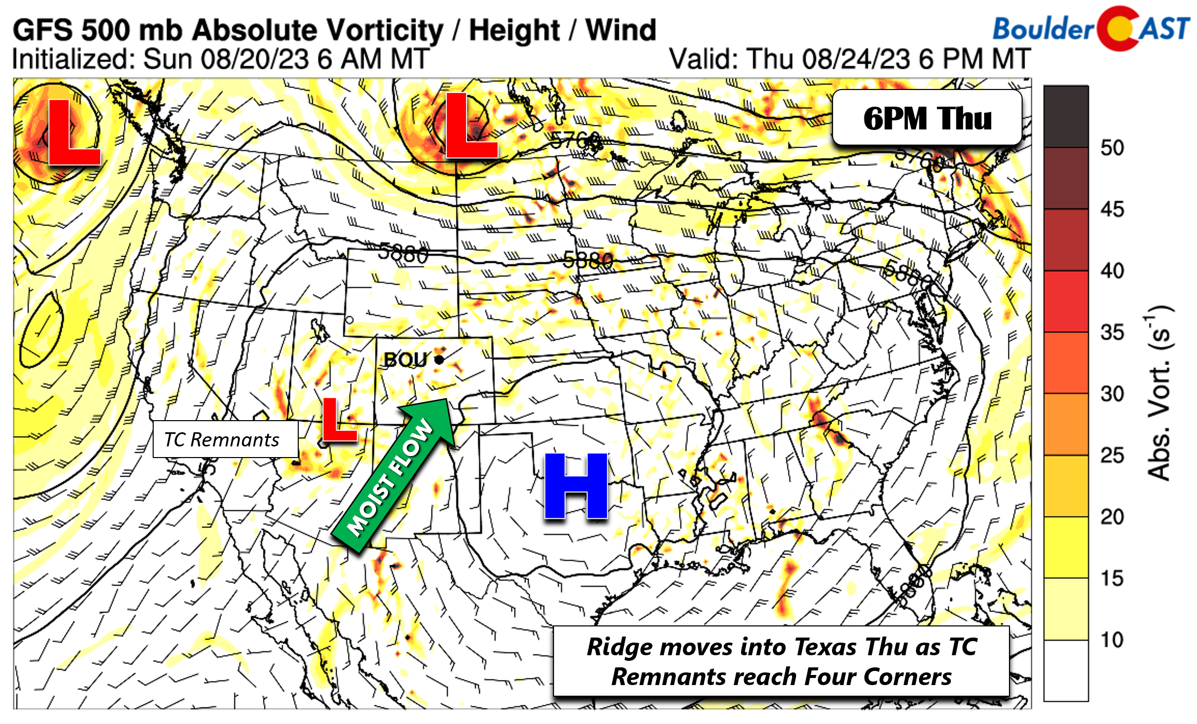
Guidance then shows the tropical remnants possibly reaching the Four Corners Thursday as the hot ridge further drifts south and then west toward the southern Plains. Moisture, if this does verify, would continue to increase Thursday, sparking more late-day storms and thus reduced high temperatures in the upper 80s to near 90. Storms would be somewhat slow moving and could bring flooding concerns for local burn scars.
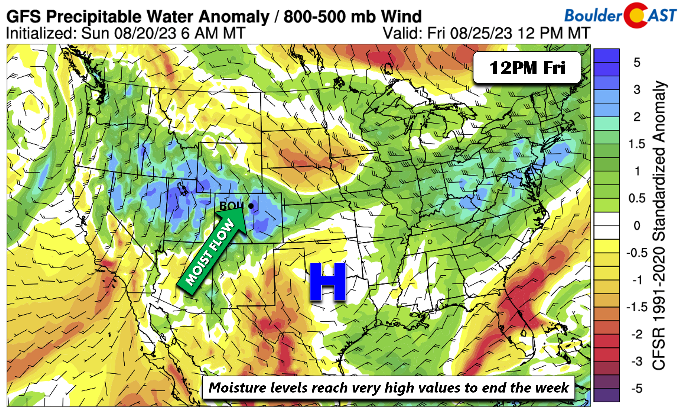
By late in the week, the moisture is poised to reach its highest values come Friday, perhaps 200% of normal! This would largely be tied to the tropical remnants but is also related to the late-season monsoon being amplified by the tropical system.
In addition, most guidance also shows a southward penetrating cold front that should arrive Friday. If this continues to be the trend, not only would highs drop considerably into the 70s or low 80s, but upslope would further aid showers/storms given the already very moist environment. Considering we are still several days out from the tropical remnants, there is definitely some uncertainty in play. The timing, placement, and details will likely be fine-tuned as we progress through the week. Even with that said, expect our best chance of storms for the latter days of the week along with our coolest temperatures during this time.
Enjoy the transition from scorching record heat to (hopefully) some tropical downpours and cooler weather throughout the week!
Forecast Specifics:
Monday: Sunny and hot with record highs likely to be tied or broken across the Front Range. Highs in the upper 90s for the Plains and upper 80s in the Foothills. A few low 100s are possible from Longmont to Greeley to Sterling.
Tuesday: Sunny and hot with mid to upper 90s for the Plains and middle 80s in the Foothills.
Wednesday: Partly cloudy with a 10% chance of isolated showers/storms. Highs in the low to middle 90s on the Plains and low to middle 80s in the Foothills.
Thursday: Increasing clouds with a 40% chance of showers/storms late in the day. Highs in the upper 80s to lower 90s on the Plains and upper 70s to low 80s in the Foothills.
Friday: Partly to mostly cloudy with a 40% chance of widespread showers or storms. Highs much cooler behind a cold front with near 80 degrees on Plains and near 70 in the Foothills.
DISCLAIMER: This weekly outlook forecast is created Monday morning and covers the entire upcoming week. Accuracy will decrease as the week progresses as this post is NOT updated. To receive daily updated forecasts from our team, among many other perks, subscribe to BoulderCAST Premium.
Go Premium, get all the perks.
Daily Forecast Updates
Get our daily forecast discussion every morning delivered to your inbox.
All Our Model Data
Access to all our Colorado-centric high-resolution weather model graphics. Seriously — every one!
Ski & Hiking Forecasts
6-day forecasts for all the Colorado ski resorts, plus more than 120 hiking trails, including every 14er.
Smoke Forecasts
Wildfire smoke concentration predictions up to 72 hours into the future.
Exclusive Content
Weekend outlooks every Thursday, bonus storm updates, historical data and much more!
No Advertisements
Enjoy ad-free viewing on the entire site.
Get BoulderCAST updates delivered to your inbox:
Enjoy our content? Give it a share!


You must be logged in to post a comment.