We’ve already had nearly three feet of snow in Boulder this season and just about a foot and a half in Denver. The action over the last six weeks has been fast and furious to say the least, but the individual storms so far haven’t been all that memorable. This is about to change! No storm so far this winter will match the caliber of the one bearing down on the Front Range right now. We discuss the set-up, timing and snow amounts expected to fall by Tuesday evening. Let’s jump right in to the very snowy forecast!
We discuss Boulder and Denver weather every single day on BoulderCAST Premium. Sign up today to get access to our daily forecast discussions every morning, complete six-day skiing and hiking forecasts powered by machine learning, access to all our Front Range specific weather models, additional storm updates and much more!
UPDATE AVAILABLE (Monday Nov 25 7:00 AM): Wow! It’s been a busy Monday morning with our storm coming ashore into the Pacific Northwest right now. We discuss the latest from the weather models this morning and ultimately why we believe historic snow totals are likely from Boulder north to Fort Collins. READ UPDATED FORECAST.
Finally a BIG one!
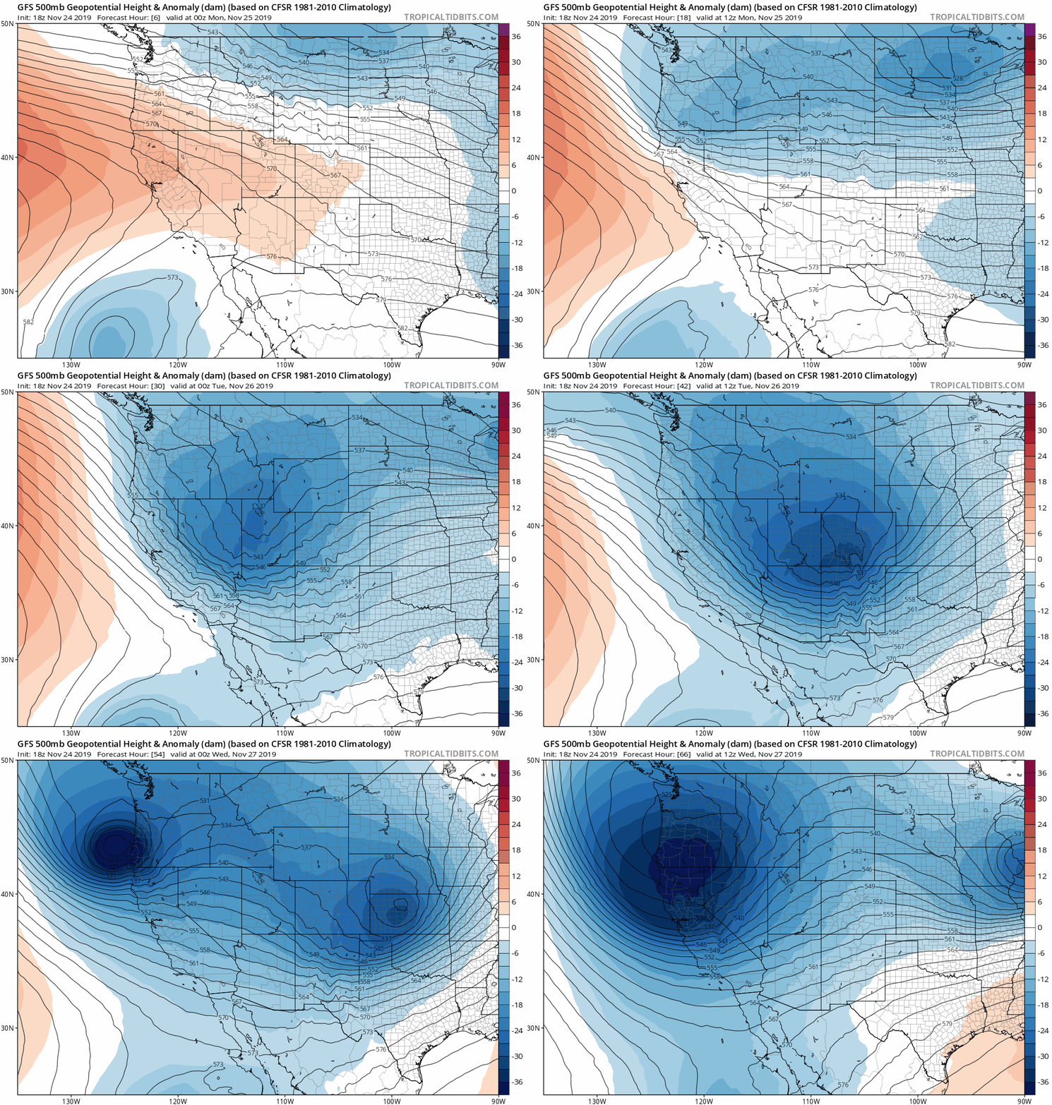
Following the late week light snow, we’ve been enjoying dry northwest flow across Colorado for the last few days. This flow pattern will finally come to bite us on Monday as an embedded wave in that northwest flow digs down into the Four Corners region and strengthens rapidly across Colorado. The GFS 500 mb height anomaly animation below shows this evolution through Wednesday morning. The storm develops and moves almost directly over us!
As the energy moves across the Continental Divide late Monday, strong lee cyclogenesis will ensue with a deep closed-low pressure system forming across east-central Colorado from the surface all the way up to the middle atmosphere. This is a scenario we dream of for BIG snow in the Denver Metro area!
Shown below is the latest NAM model forecast for 700 mb on Tuesday morning. This position of the intensifying low is fairly consistent between all models and results in impressive 25 to 35 knot east-northeasterly upslope wrapping counter-clockwise back into our area.

NAM 700 mb temperature and wind forecast map for Tuesday morning. A strong closed-low in east-central Colorado is evident with fierce upslope into Boulder projected
Here is a closer look at the juicy upslope from the GFS (left) and NAM (right) models. As you can see, there is considerable agreement between the two in most aspects of the storm. While not shown, the European model is producing an almost indistinguishable set-up as well.
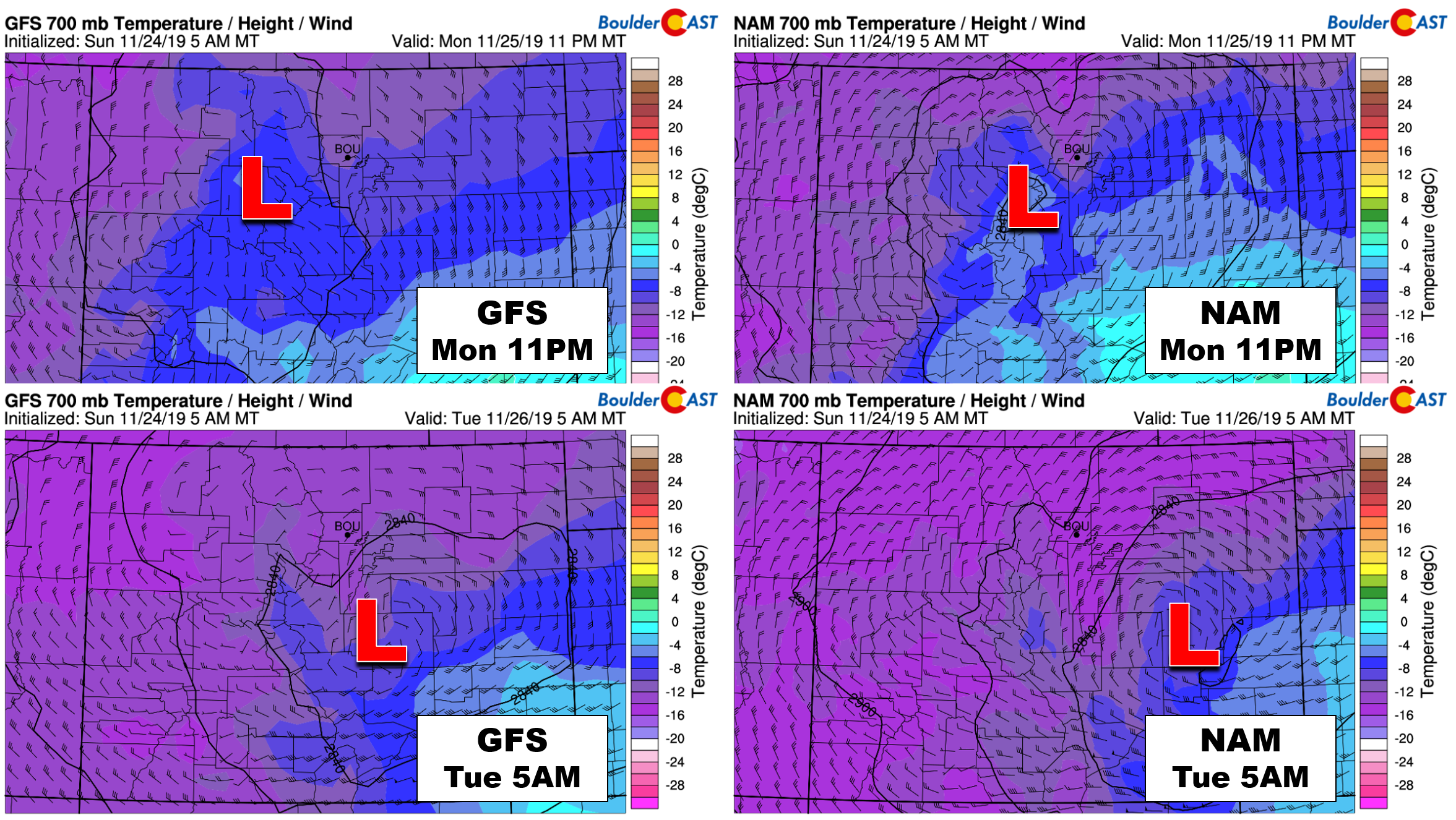
700mb temperature and wind forecast maps from the GFS (left) and NAM (right) for Monday night (top) and Tuesday morning (bottom)
Another thing that will help the snow pile up: generous snow-to-liquid ratios are expected due to temperatures aloft aligning with the favorable regime for dendrites, that is, in the -12 to -18°C range. A deep layer of just the right cold air capable of producing dendrites will overtake the Denver Metro area during the peak of the storm. Ratios between 13:1 and 17:1 are expected as a result.
BIG snow amounts are coming
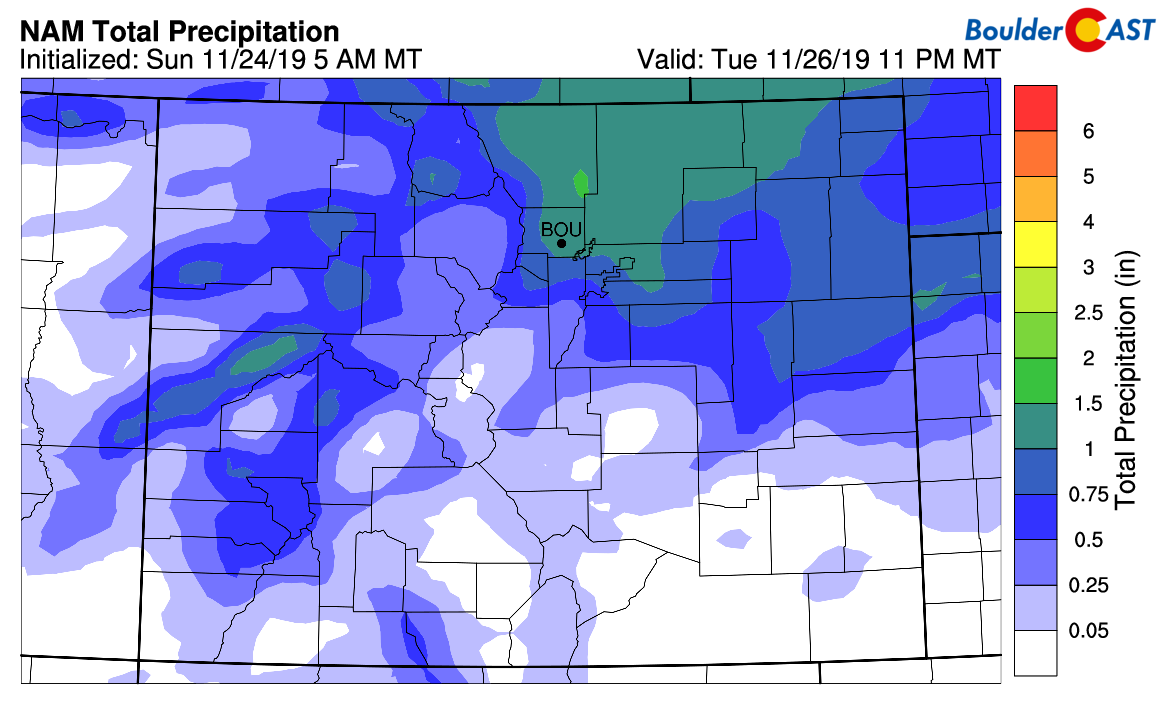
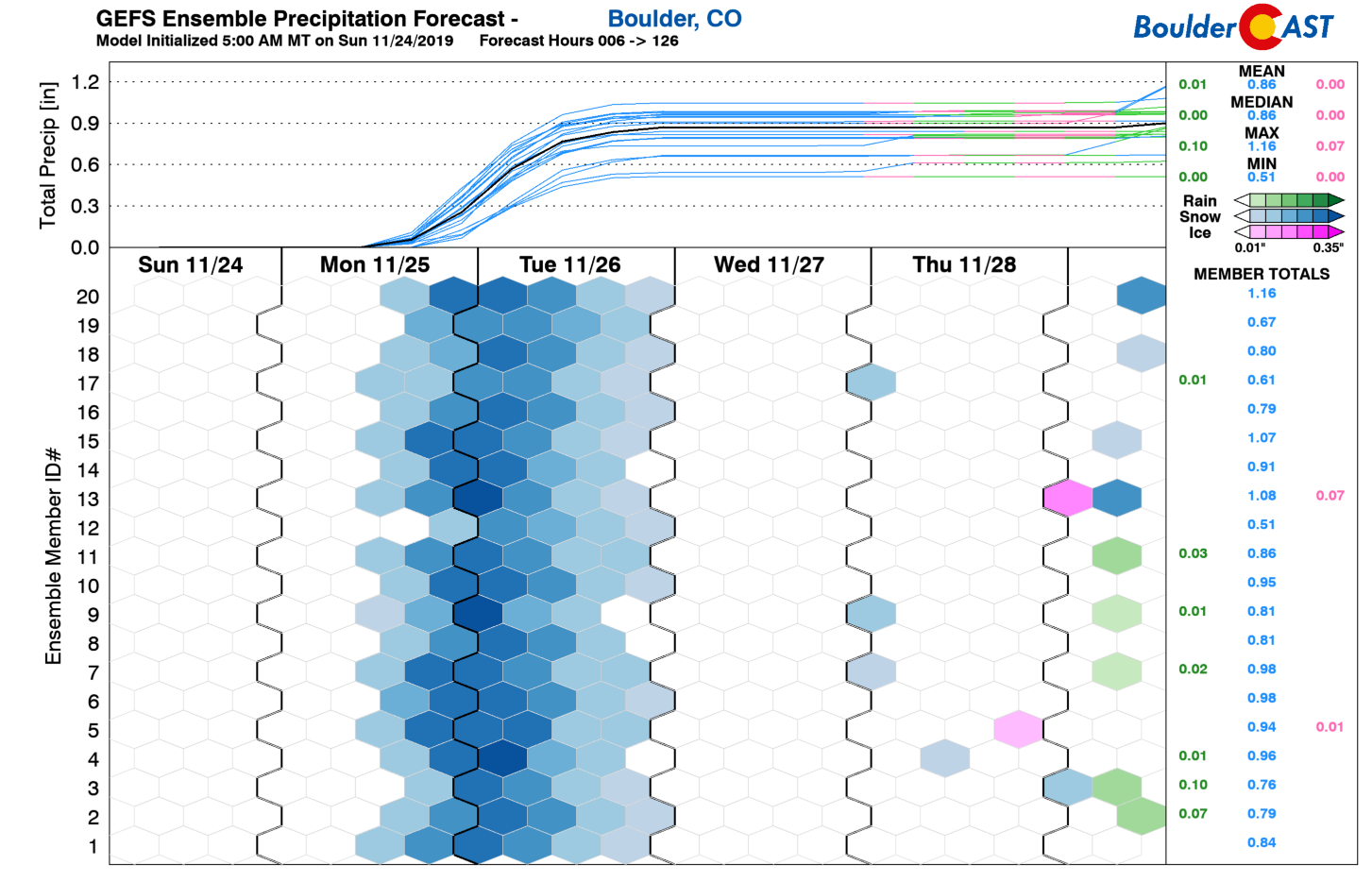
Models are indicating anywhere from 0.5″ of liquid across extreme southern Denver to 1.2″ in the Foothills of Boulder and Larimer Counties.
Even the ensembles are on-board for these liquid amounts, if not just a shade lower. The gradient in amounts is due to the low pressure tracking almost exactly over our area from west to east. On the north side of the low, upslope will be prevalent and deep. However, south of the low, dreaded downslope will be a factor (sorry Colorado Springs!).
This is the BIG one folks! After a lengthy debate between our team of meteorologists, literally none of us were left doubting this storm for any reason whatsoever:
- We couldn’t imagine a better track for the 700 mb low pressure from east to west across Colorado. The positioning is nearly perfect for the northern Denver Metro area with the resulting upslope being juicy, intense and fairly long-winded (no pun intended!).
- The upper-level dynamics of the storm bring very impressive lift across the entire Front Range Monday evening into Tuesday morning. There is also strong frontogenesis during this time and possibly brief lift from the left-exit region of an overhead jet streak.
- A deep saturated layer of ideal temperatures aloft for dendrites to form will facilitate fluffy snow throughout the event. 14:1 ratios are expected, if not closer to 18:1 at some points during the storm.
- The overnight and morning timing, combined with temperatures in the 20’s falling into the teens, will allow for very little melting. Whatever falls sticks.
- Not only will all of the aforementioned ingredients be in-play, they will almost all overlap perfectly leading to very efficient (i.e. heavy) snowfall rates for an extended period (12 to 18 hours).
- The models are now all synchronized and consistent. The Euro had been further north with the track, but has since come around. Overall agreement is now very good, almost too good.
As a result of all of these factors, both their existence and their coincidence, areas from Denver north to Cheyenne will get absolutely hammered with heavy snow from Monday evening into mid-day Tuesday. Snowfall rates during the height of the storm will range from 1 to 2″ per hour for many hours in many locations. Overnight travel into early Tuesday could be borderline impossible in some locations, especially north and west of Denver, through Boulder and Fort Collins into the Foothills. The only positive for travel is the lack of strong winds. That’s right, this won’t be a blizzard or a bomb cyclone, just a classic Front Range snowstorm.
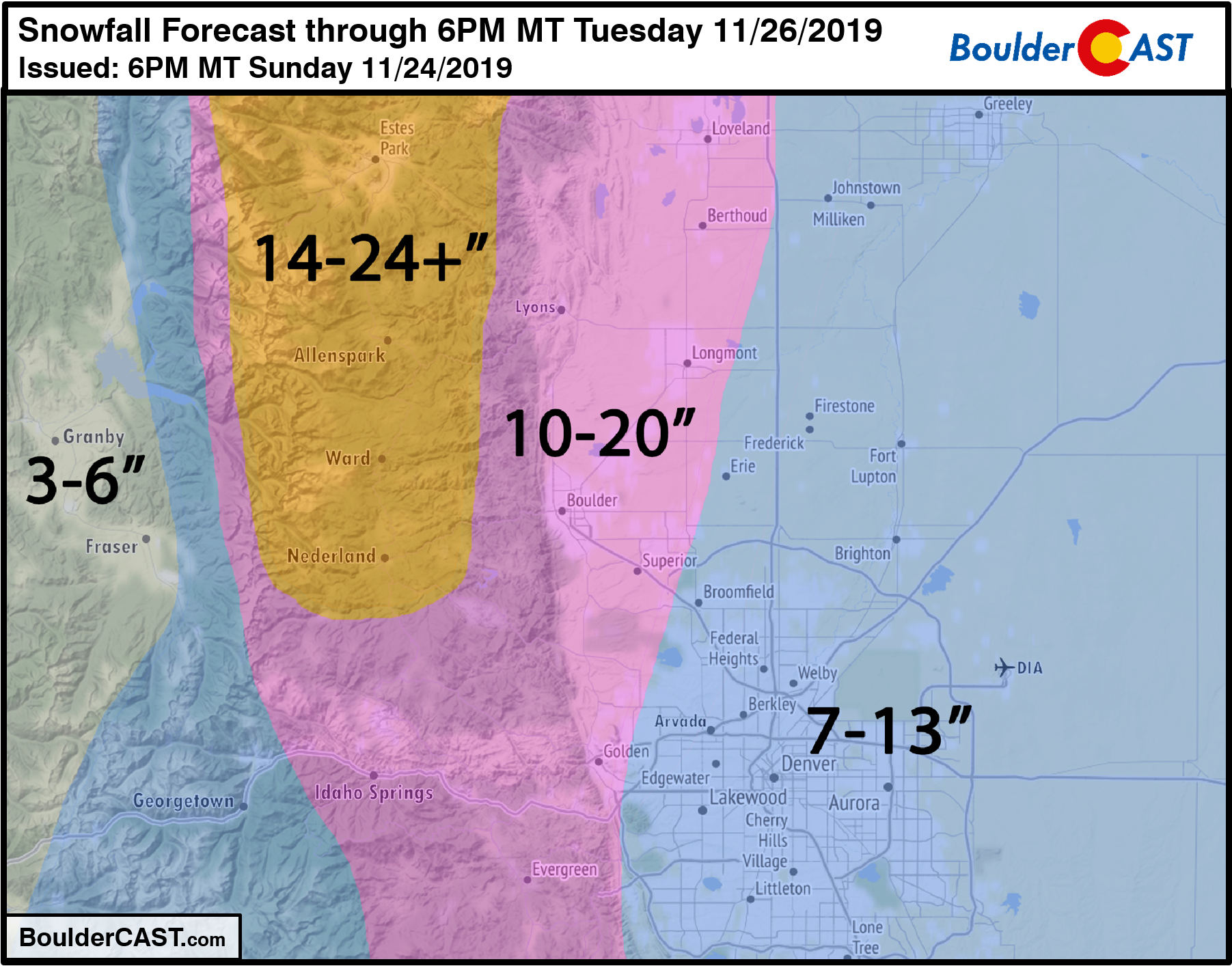
For once, we are able to issue a forecast for BIG snow totals up and down the Front Range with moderately high confidence. There is still some potential for a bust if the storm’s track shifts even by as little as 20 miles. The trend in the models over the last one or two days has been southward, however. This is the direction that we would expect such a shift in the future, if it did happen. This would bring the higher totals even further southward (i.e. more snow to Denver proper).
Our snowfall forecast map for the event is shown below.
This storm is also another case where we had to create a “special run” of our Snowfall Probability Charts due to the large amounts. Here are the latest probabilities which align nicely with our forecast.
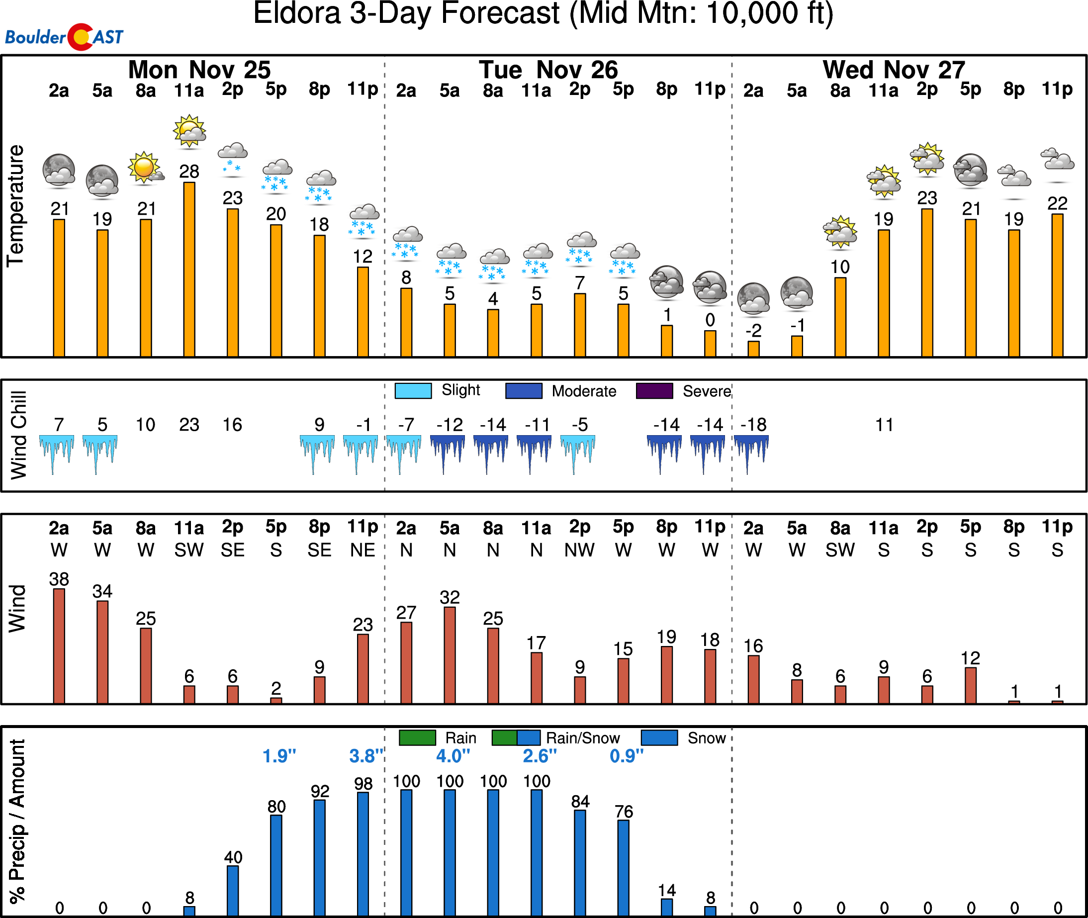
While not a great storm overall for the Mountains, the only resort east of the Divide, Eldora, should get a nice dumping thanks to the strong and deep upslope easterly flow.
Storm Timeline:
Let’s take a minute to talk about the timeline for the impending storm as travel throughout will be without a doubt significantly impacted.
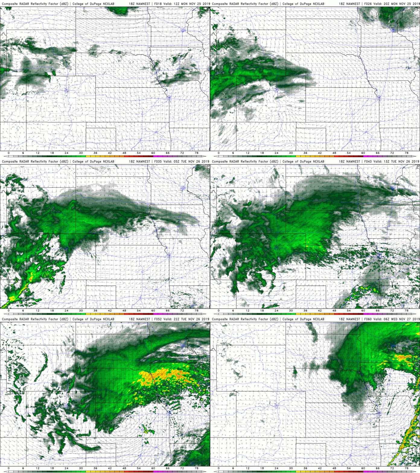
- Snow will begin to spread southward across northern Colorado during the afternoon Monday. Current model trends show an arrival to Boulder near or just before rush hour and into Denver a shade after rush hour. There may be a few sprinkles of rain at the onset, but this will quickly change-over to heavy snow with temperatures falling below freezing.
- A prolonged period of moderate to heavy snow is expected Monday evening and night into Tuesday morning as all of the ingredients come together in full-force. Snowfall rates in excess of 1″ per hour will be common during this time making travel difficult region-wide. Don’t attempt the Tuesday morning commute unless you must. You have been warned!
- Snow will decrease in intensity and coverage by late morning Tuesday into early afternoon, fully ending by sunset for even the most southern and eastern fringe of the Denver Metro.
- Temperatures will fall into the 20’s Monday night and into the teens by Tuesday morning and remain there through the rest of the day. Lows drop into the single digits Tuesday night.
That’s all for now folks. If we see any need for major changes to the forecast as the storm approaches, we’ll keep you updated. Subscribe to BoulderCAST to get instant email notifications when our new forecasts go live, and don’t forget to follow us on Facebook or Twitter.
Now go forth and gather your milk, eggs, and bread from the local supermarket. It may already be too late!
LIMITED TIME OFFER: Until the snow stops on Tuesday afternoon, use the promo code BIGSNOW to save 25% on BoulderCAST Premium.
We discuss Boulder and Denver weather every single day on BoulderCAST Premium. Sign up today to get access to our daily forecast discussions every morning, complete six-day skiing and hiking forecasts powered by machine learning, access to all our Front Range specific weather models, additional storm updates and much more!
.
Spread the word, share the BoulderCAST snow forecast!





You must be logged in to post a comment.