A recap of yesterday’s hailstorms, a discussion of today’s forecast which contains more hail, and a look at the eye of Category 4 Hurricane Bud from GOES-16.
Remember, these daily forecasts are Premium content. Periodically, we open this forecast up to all of our readers. Today is one of those days!
Sign up today to get the best BoulderCAST experience, including these daily forecasts every morning, complete 6-day skiing and hiking forecasts, chat room and forum access, early viewing of select content and much more!

Large hail abound on Monday evening
Damaging hail dumped across parts of the northern Denver Metro yesterday as a slow-moving line of storms developed east and north out of Boulder through the evening. Much of Monday was plagued with pesky clouds, but sunshine took over by the middle of the afternoon and instability began to rapidly build in the atmosphere due to heaps of low-level moisture. Adequate shear fueled to the development of nearly a half dozen long-lasting supercell thunderstorms across the northern Front Range. The original point of initiation Monday early evening was near Nederland.
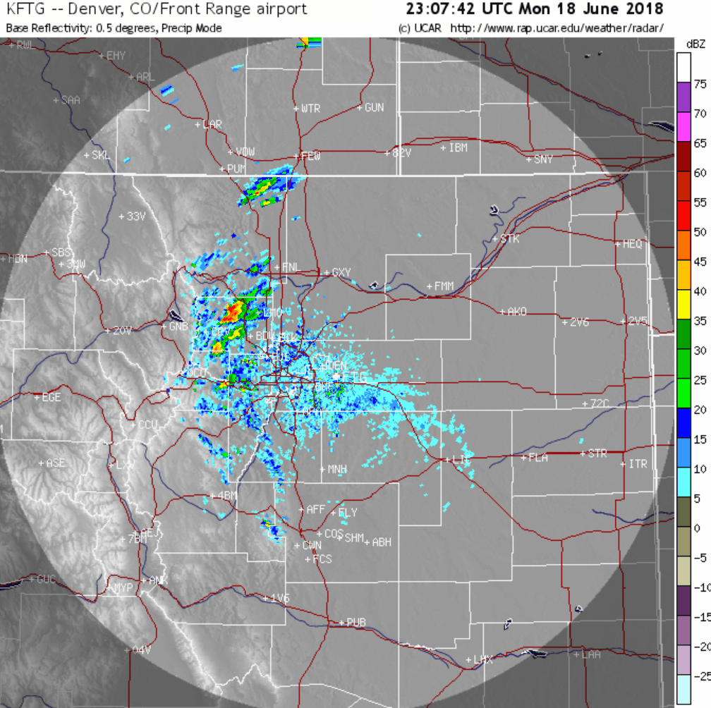
Radar loop from June 18, 2018 showing a line of severe thunderstorms which produced large hail across Boulder and the northern Denver Metro area.
Models did a decent good job predicting that these storms would form. Sure….the timing was delayed by a few hours (due to the lingering clouds) and the location was also slightly further west, but nonetheless, they nailed it. The net result was some of the largest hail falling in many, many years in the city of Boulder and surrounding communities. We dug through the mess of hail and found numerous hailstones around 2.00″ in diameter.
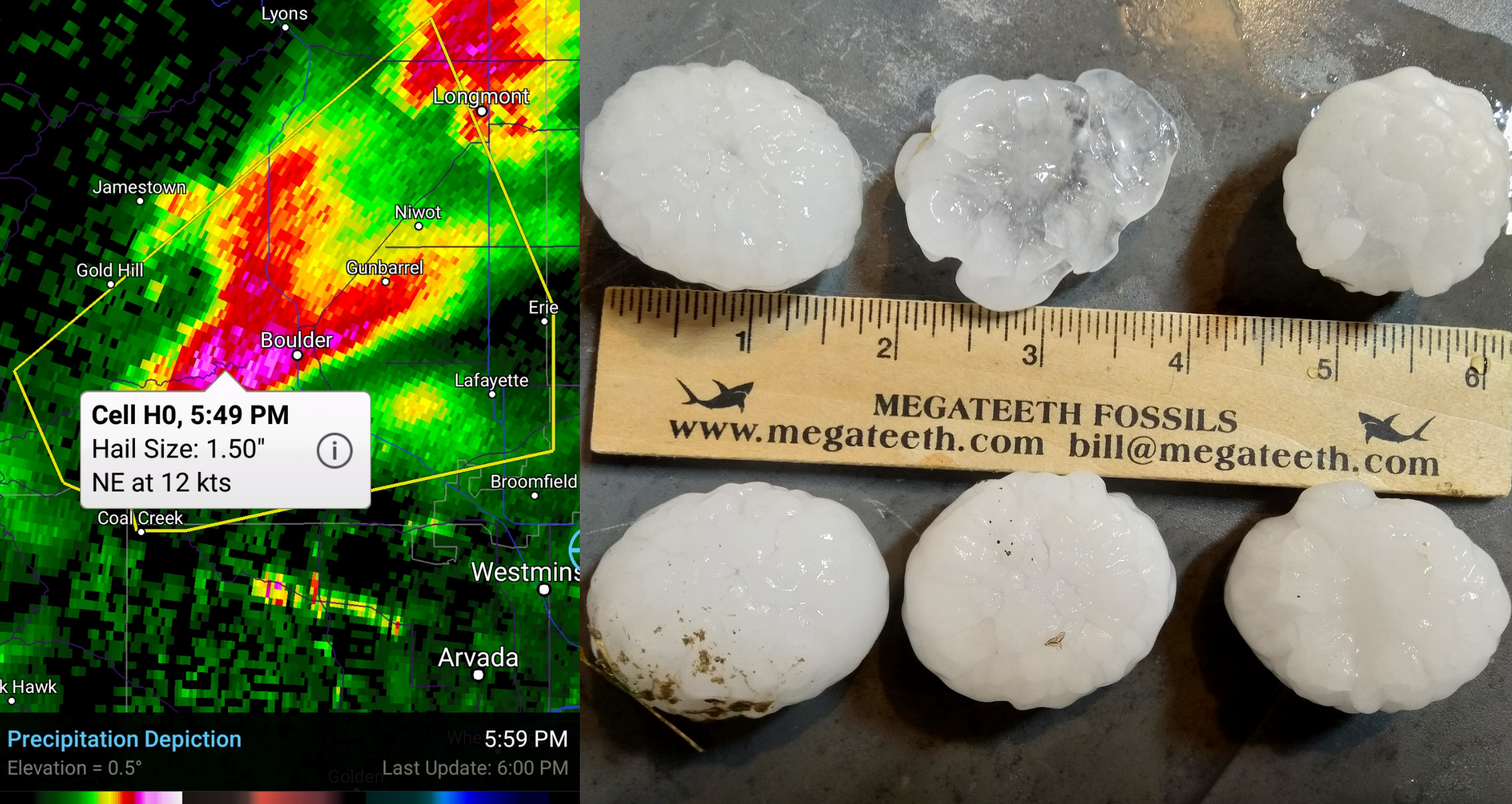
Radar image and resulting hail from Monday June 18, 2018 in the Boulder.
The largest hail reports we saw came from near Louisville and Brighton at 3″ (~baseball-sized). However, radar at times was resolving hail cores containing up to 3.75″ in the remote farmland areas east of Greeley. It’s likely these large hailstones went unreported.
Rainfall totals were impressive in a narrow band extended east-northeastward from Boulder along Interstate 76. Parts of central Boulder received around 1.5″ of rain. Further south, downtown Denver only saw a few measly drops. Radar-derived rainfall estimates for last night are shown below. Note the extraordinarily heavy rainfall and the localized string of of areas that were hit hard. While the magnitude is likely thrown off a little by large hail being present in the storms (large hail gets captured as ridiculously heavy rainfall in these estimates), the yellow star on the map had a ground report of 4.84″ of rainfall, which does match the radar estimate nicely.
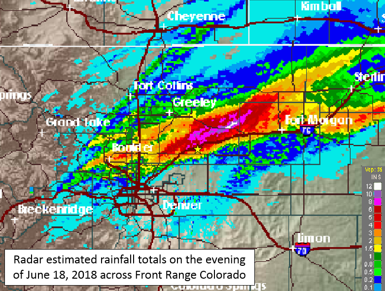
Doppler radar estimated rainfall totals for June 18, 2018. The yellow starred location reported 4.84″ of rainfall.
What a way to start the work-week… Be sure to get your insurance claims filed immediately!
Today’s forecast: Spotty storms, chances of hail return
A similar pattern to yesterday will be in place today. We’ll begin the morning with low clouds, fog, and some drizzle across the region. We do expect this to clear out by late morning. However, just like yesterday, the sunshine will lead to the development of afternoon thunderstorms across the region. The 500 mb vorticity map below shows there will also be a strong shortwave moving through Colorado late this afternoon and evening, which will provide large-scale lift to enhance the storms a little.
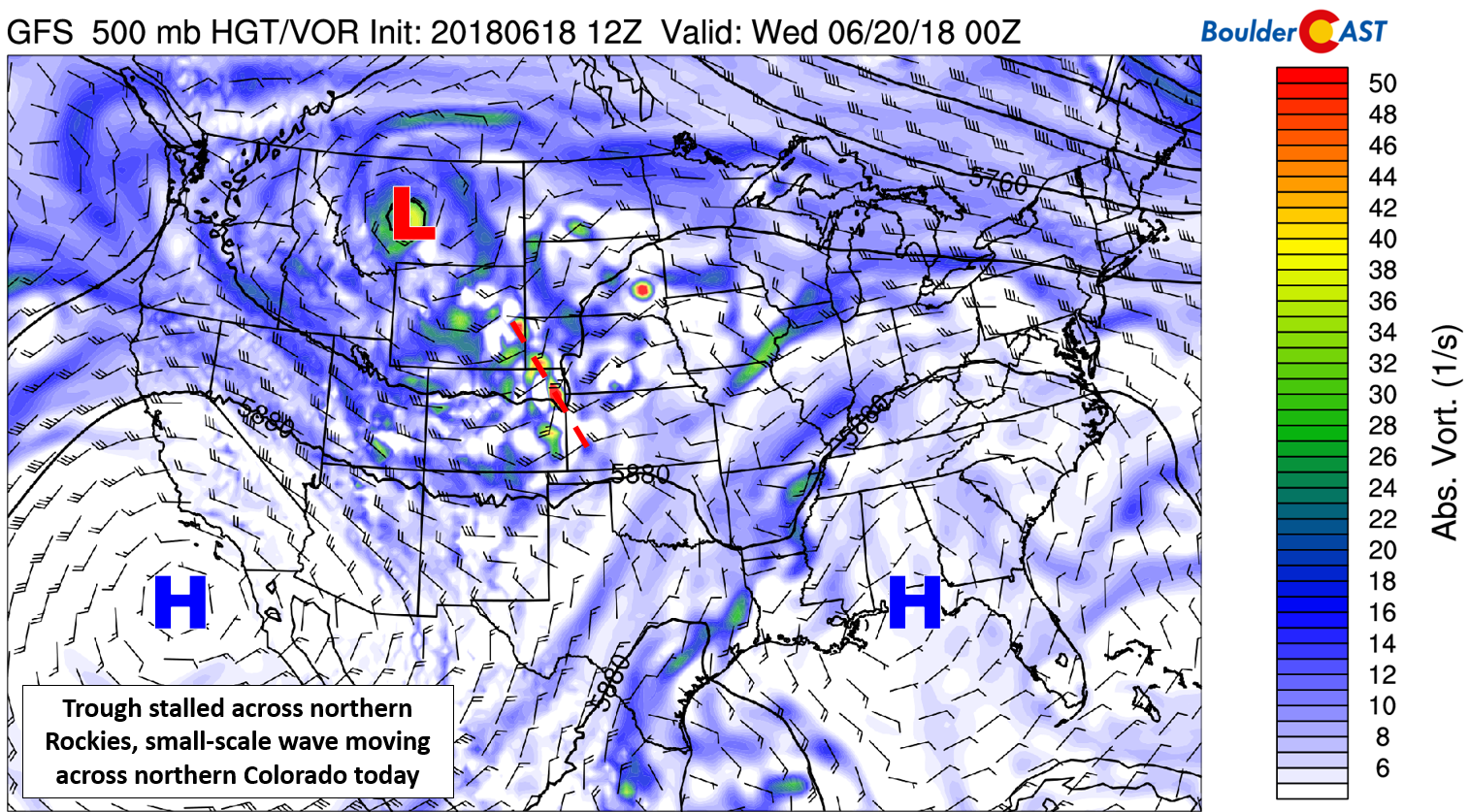
GFS 500 mb map for today. A shortwave will be traversing across Colorado helping to amply instability this afternoon and evening.
The stalled frontal boundary which fired-off the supercells yesterday has sagged slightly further south today (see below). We expect the focus for most of the severe storms this evening to be east and/or south of Denver, right in the vicinity of this boundary.
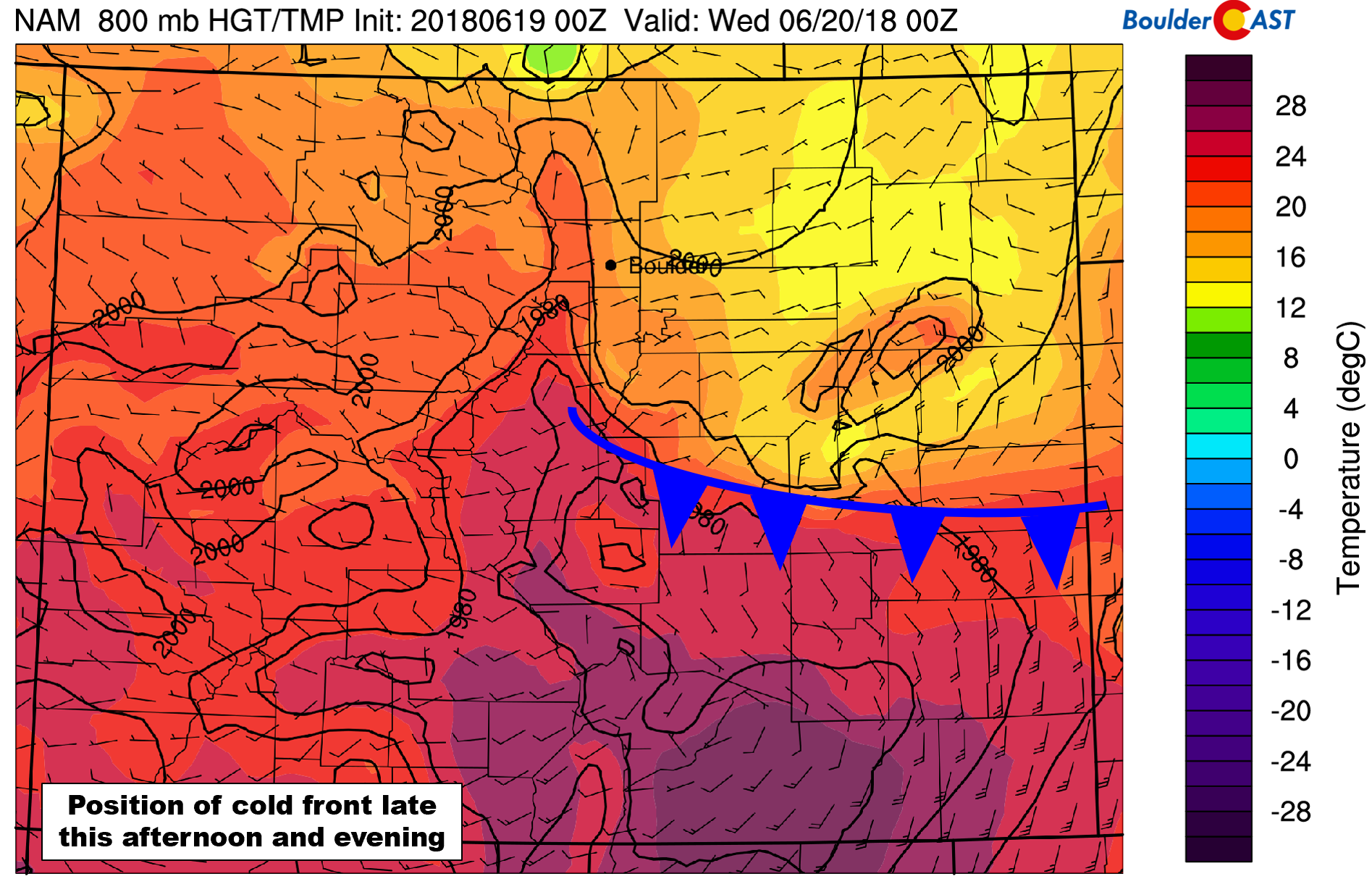
NAM 800 mb temperature and wind forecast map for this evening. The cold front is about 100 miles further south than yesterday. Notice the strong temperature gradient and converging winds along the front.
Still there will be a decent chance of rain across the northern Metro area, too. Storms will begin forming across the Foothills by early to mid afternoon, then move eastward onto the Plains where they will intensify. We’re forecasting about a 30% chance of storms between noon and midnight for the Boulder/Denver area. The threat for large hail returns but will be similarly focused east and south of Denver. Hail in the 2″ to 4″ range is totally possible along with a weak tornado or two. Models don’t have a great handle on the situation this afternoon, varying in location and timing of the severe weather. We’re confident that there will be a good deal of severe storms today, it’s just not entirely clear where they will land. The easy part of the forecast: temperatures should top out in the middle 70’s.

Hurricane Bud’s eye from GOES-East
Hurricane Bud’s post-tropical remnants played a large role in the rainfall we saw here in Colorado over the weekend and even indirectly in the hailstorms we saw yesterday. The GOES-East (a.k.a GOES-16) weather satellite captured some truly marvelous imagery of the cyclone’s eye spinning off the coast of Mexico as a Category 4 hurricane last Wednesday morning (June 13th, four days before reaching Colorado). Did you know that GOES-16 allows meteorologists on the ground to “zoom” the satellite in real-time to point at areas on the planet where cool weather is happening? When zoomed in, GOES-16 can capture imagery at a spatial resolution of just 0.3 miles and a temporal resolution that is 10 to 30 times higher than its normal capture mode.
Last Wednesday, NOAA meteorologists decided to point GOES-16 at Hurricane Bud. A less-then-impressive still image of the Bud’s eye is shown below. For the full, absolutely mesmerizing animation of the eye doing its thing, click HERE. Seriously, you won’t regret watching this short video!

Created by CIRA of Colorado State University.
Read more about the satellite’s imager and different capture modes HERE.
.


You must be logged in to post a comment.