If you thought Monday’s sunshine was the start of a quiet week, think again. The next 48 hours will bring a dramatic shift in our weather —starting with breezy but pleasant conditions Tuesday, then escalating into a powerful downslope windstorm with heightened fire danger on Wednesday. And just when you think it’s wrapping up, a sharp cold front will crash the party with blustery conditions and even a chance for rain and snow Wednesday evening.
We’ll break down what to expect, where the strongest winds will hit, and how this event stacks up against the day of the Marshall Fire. Plus, we’ll look at the potential for Xcel power shutoffs (spoiler: it’s going to be happen).
What You Need to Know
- 🌤️ Tuesday stays mild — highs in the low to mid‑60s, more wave clouds, and breezy gusts of 15–20 MPH.
- 💨 Damaging downslope windstorm Wednesday — gusts of 50–85 MPH possible west of I‑25, strongest in Boulder/Rocky Flats/Foothills. Strongest from midday into early evening.
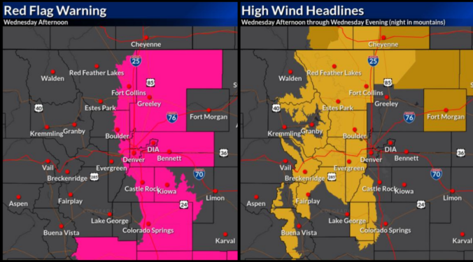
- 🔥 High fire danger — Red Flag Warning in effect Wednesday 11AM–6PM below 6000 feet; extreme winds + low humidity (15–22%).
- ⚡ Likely power shutoffs — Xcel will most certainly cut electricity in Boulder/Jefferson Counties Wednesday to reduce wildfire risk. Other counties are likely to see cuts too. Outages could last well beyond the wind event itself.
- 📉 Not a repeat of the Marshall Fire — fuels are less abundant, drought less severe, and winds weaker/shorter-lasting than December 2021.
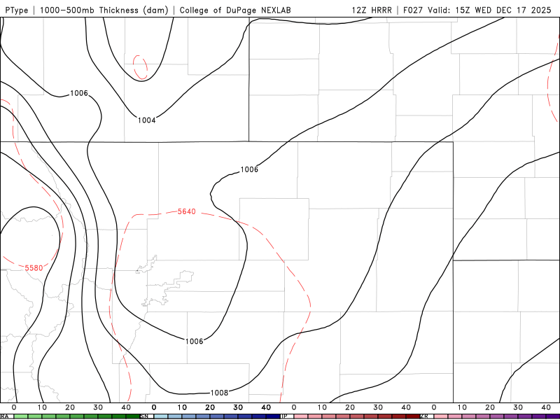
- ❄️ Cold front arrives Wednesday evening — blustery conditions, scattered rain/snow showers possible in Denver/Boulder 5–10PM, little accumulation.
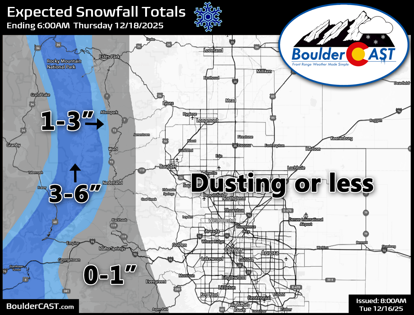
- 🏔️ Mountain snow — 3–6″ along the Divide with localized squalls and whiteouts; Foothills above 8000 feet <1″.

Go Premium, get all the perks.
Daily Forecast Updates
Get our daily forecast discussion every morning delivered to your inbox.
All Our Model Data
Access to all our Colorado-centric high-resolution weather model graphics. Seriously — every one!
Ski & Hiking Forecasts
6-day forecasts for all the Colorado ski resorts, plus more than 120 hiking trails, including every 14er.
Smoke Forecasts
Wildfire smoke concentration predictions up to 72 hours into the future.
Exclusive Content
Weekend outlooks every Thursday, bonus storm updates, historical data and much more!
No Advertisements
Enjoy ad-free viewing on the entire site.
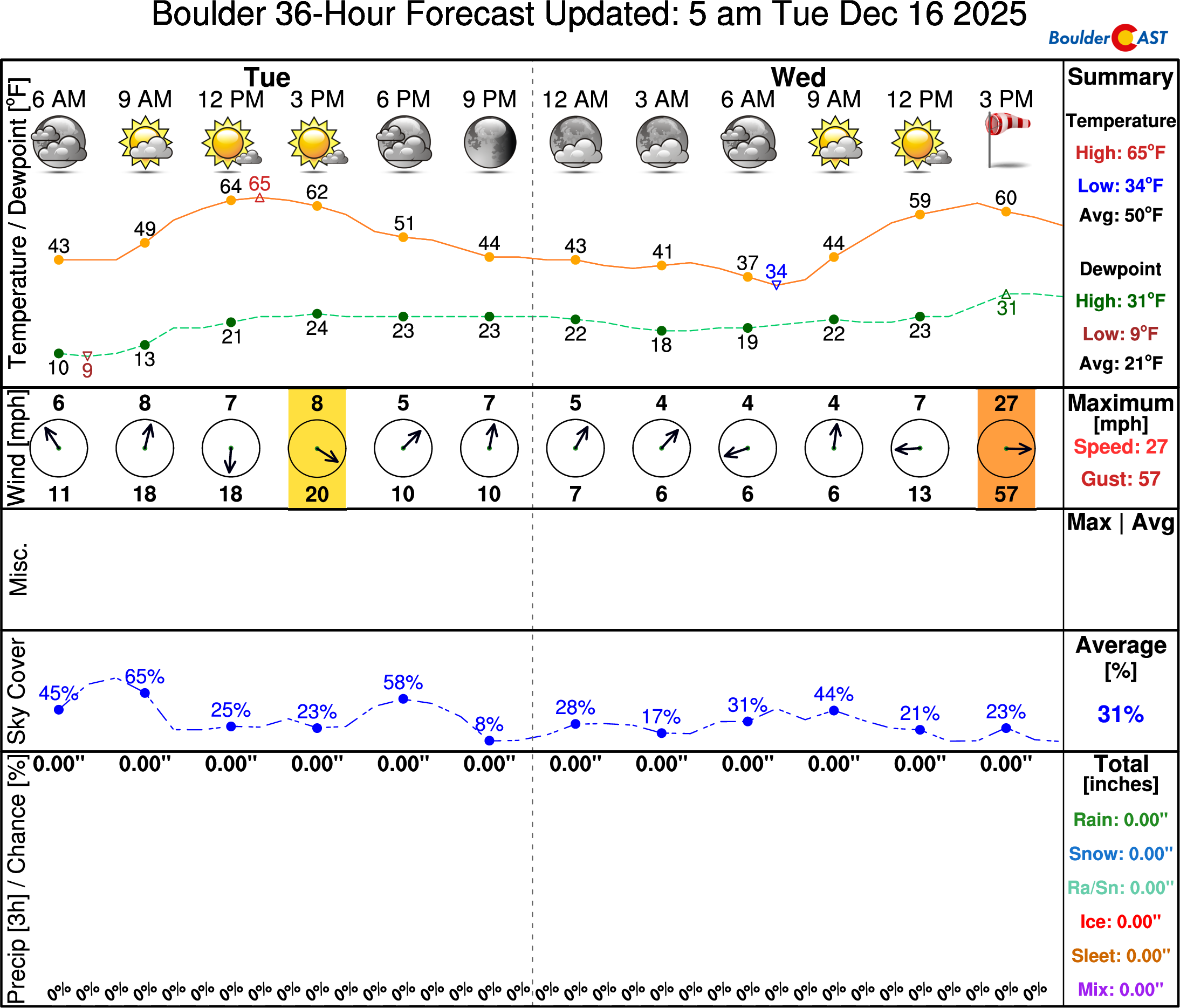
Tuesday: The calm before the storm
First things first, Tuesday’s forecast is straightforward. Monday was picture-perfect in Boulder—warm, sunny, and calm. Tuesday will feel similar, though expect more wave clouds overhead and a bit of breeze. Gusts of 15–20 MPH are possible, but nothing close to what’s brewing for tomorrow. Highs will again reach the low to mid 60s.
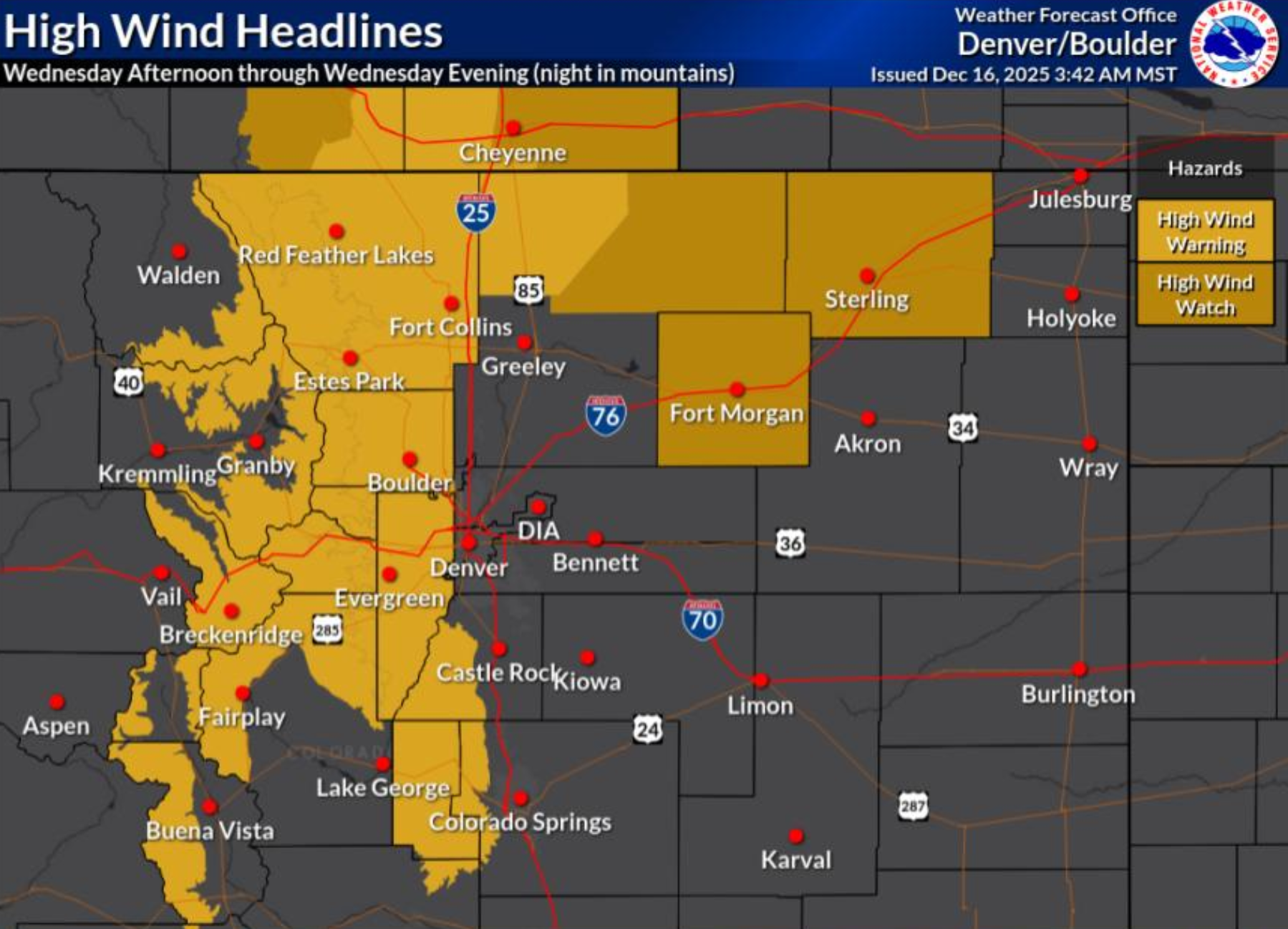
High fire danger alongside damaging downslope winds
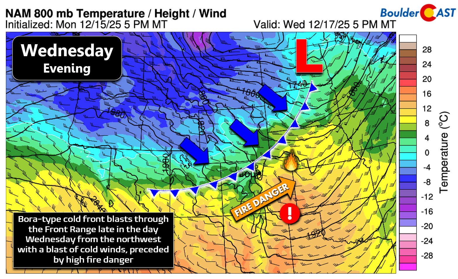
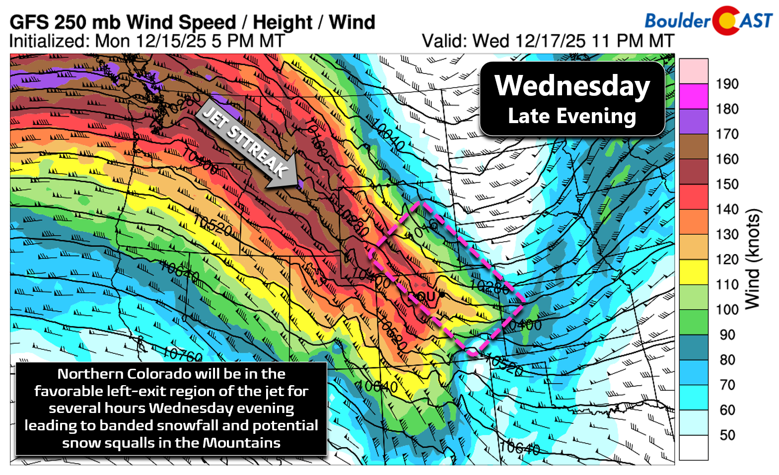
Our current ridge of high pressure will begin to break down Tuesday night into early Wednesday, and eventually it’ll get shunted southward by a punchy shortwave screaming along the Canadian Border Wednesday night. This system, and the intense jet streak wrapped around its base, will bring the Front Range a period of strong downslope winds during the day Wednesday into Wednesday night.
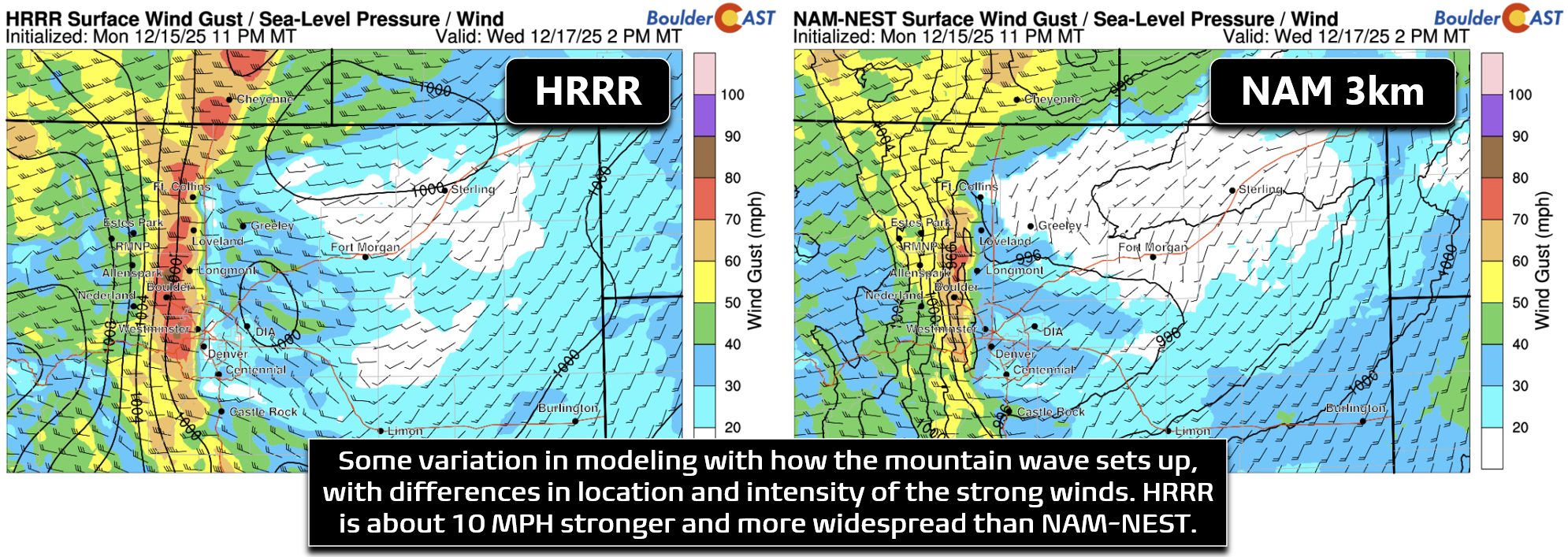
The primary concern right now is for a relatively short-lived but extremely intense period of winds in the Foothills, Boulder and the western suburbs of Denver as a mountain wave briefly develops during the day Wednesday ahead of the cold front. With previously mixed forecast guidance, we were unsure whether this feature would come to fruition or not , but now that the short-range models have had their look, confidence has increased that this intense windstorm should indeed happen. The mountain wave dynamics are brief but will offer strong enhancement of winds from late morning Wednesday into the early evening. Winds will cascade down the eastern slopes of the Rockies into the Metro area, with gusts of 50 to 85 MPH possible west of Interstate 25. The latest run of the HRRR model below has winds shifting from almost calm in Boulder to an extreme wind event in the blink of an eye around midday Wednesday, with the strongest winds occurring Wednesday afternoon into early evening.
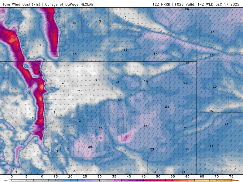
There are some differences in modeling with how far east the strong winds will reach, and also with intensity. This of course plays into which communities will be impacted versus spared. The HRRR model is about 10 MPH stronger and has the winds pushing eastward all the way to Interstate 25 if not farther (below left). The NAM is less intense and keeps things several miles farther west (below right).
Regardless of where this windstorm ultimately lands, we need to be extra cautious here—this isn’t the usual windstorm that will only impact the Foothills and wind-favored locales like Boulder and Rocky Flats. This event will more broadly slam almost everywhere west of Interstate 25 with 50+ MPH damaging wind gusts for at least a couple hours, with peak gusts in wind-favored areas like Boulder reaching up to 85 MPH and the window for damaging winds being longer there. Gusts this strong can down trees and powerlines, topple tractor trailer trucks, and blow down the many fences of suburbia.
Unfortunately the strongest winds Wednesday afternoon will also briefly overlap with a period of near-critical relative humidity ranging from 15 to 22% across the lower elevations.
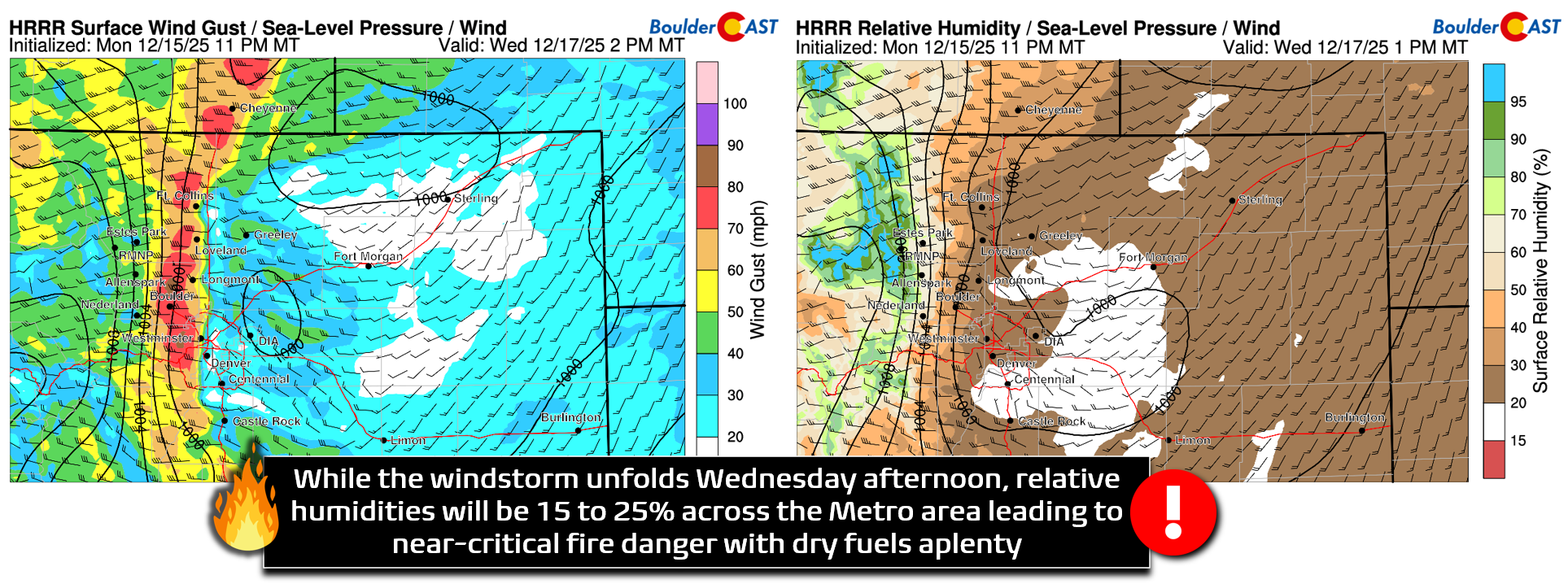
While humidities will mostly be above the threshold that would typically trigger a Red Flag Warning, the National Weather Service has opted to issue one anyways given the extreme winds in the forecast and the dry fuels present across the drought-stricken Front Range. Any fire ignition would have several hours to rapidly grow Wednesday afternoon into the early evening.
Red Flag Warnings are in effect everywhere below 6000 feet elevation from 11AM to 6PM on Wednesday.
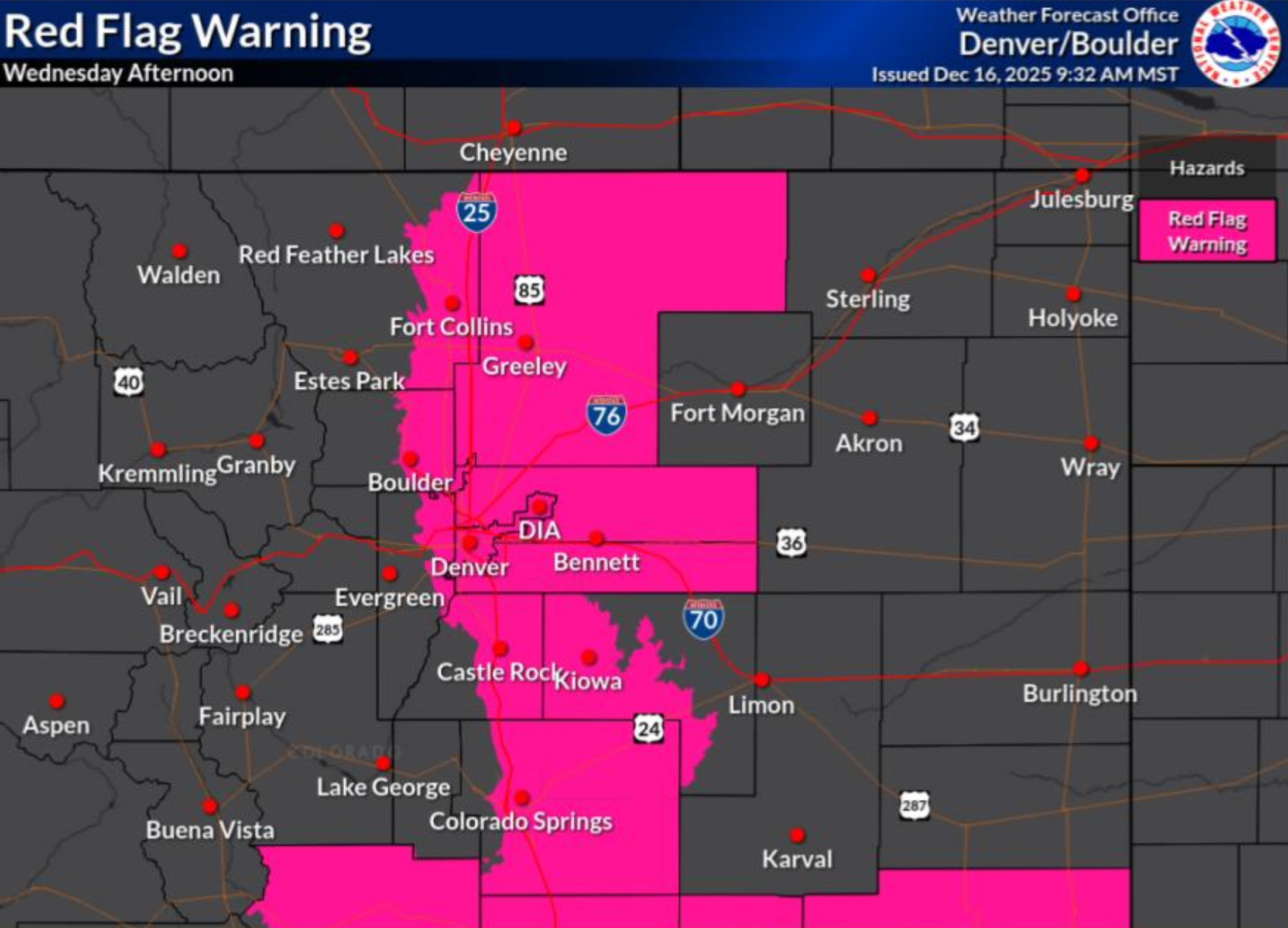
Boulder, the western Denver suburbs, the Foothills and the Mountains also have a co-timed High Wind Warning running from 11AM to Midnight on Wednesday.
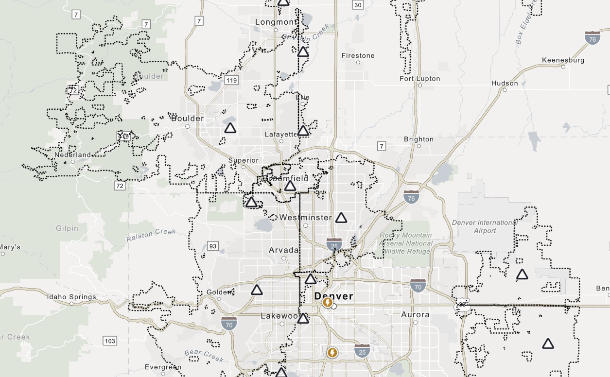
Whether you agree with it or not, given the situation at hand, Xcel Energy is highly likely to conduct a Public Safety Power Shutoff on Wednesday as a preventative measure against wildfire ignitions from downed powerlines.
At the time of writing Tuesday morning, all we have to go from is the preliminary shutoff map that Xcel advertised to us on Monday (below). Everywhere inside the dotted lines is currently being considered for a potential shutoff, including a large portion of Boulder County. As it stands now, this is a huge area impacting more than a half million Xcel-serviced residences across the Front Range. Given the way the forecast is looking, we do fully expect Xcel to move forward with de-energization of some of our local power grid, though it probably won’t be as broad as shown in the map right now. Boulder and Jefferson Counties are the most likely to see power cut, with most areas east of Interstate 25 possibly in the clear. Xcel is expected to announce their final shutdown plans sometime during the day Tuesday or Wednesday morning at the latest, so stay tuned. If power is cut, that would probably happen sometime in the late morning Wednesday, with the planned outage ending Wednesday night or Thursday . Remember that these type of shutdowns often last longer than the actual high winds themselves as utility crews work to assess the grid and ensure that any powerlines that were damaged are repaired before power is fully restored. In past events like this, we have seen the planned shutdown last for days beyond the end of the winds in the Foothills west of Boulder, so plan accordingly. The power may be out longer than expected—perhaps much longer. You can check for updates and zoom in to this map over on the Xcel Outage Map and find additional updates on the situation on the Shutdown Event Update page.
Comparing to the Marshall Fire
We’ve gotten a lot of questions from the broader community which is on edge regarding this windstorm and how it relates to the day of the Marshall Fire. It’s only natural to draw comparisons to December 30, 2021. There are similarities—but also important differences.
Similarities:
- Dry fuels and drought conditions
- Intense downslope windstorm enhanced by a mountain wave
- Low but non-critical humidity
Differences:
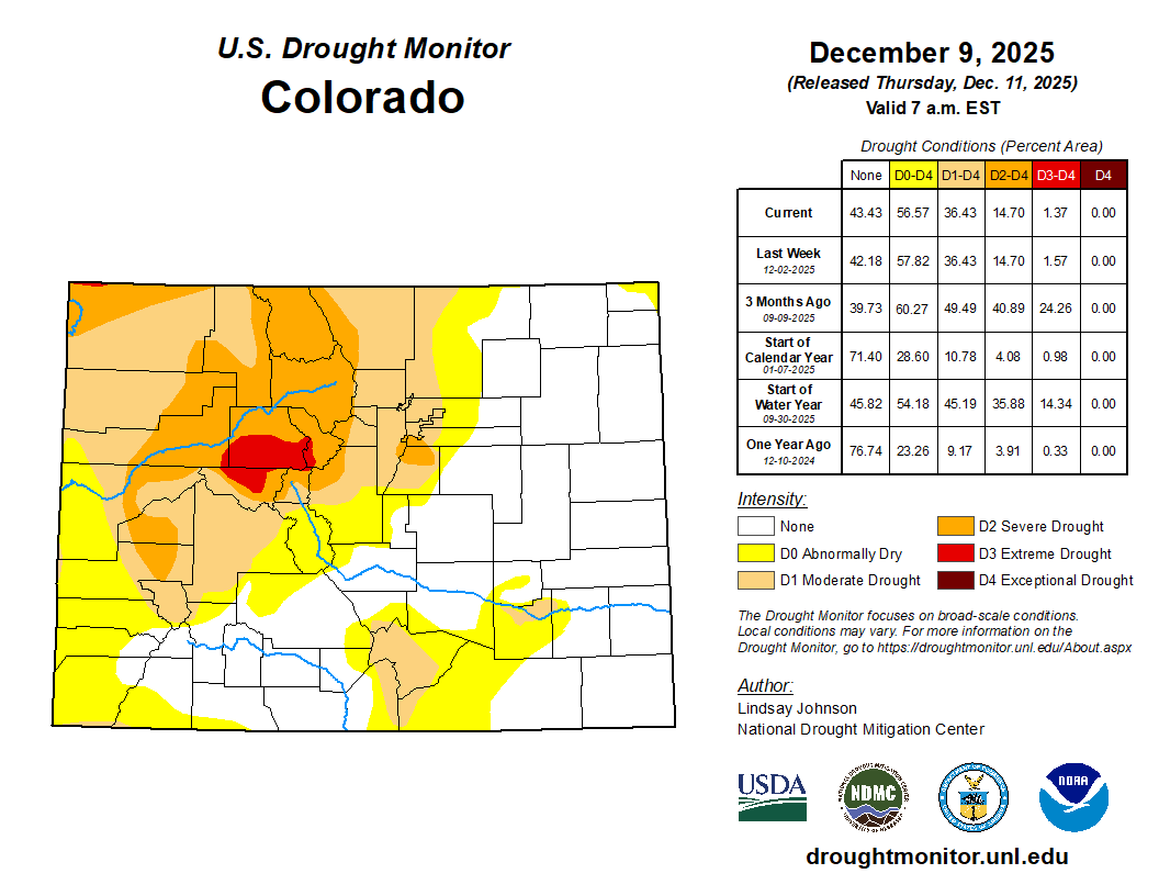
- Current drought is not as extreme as 2021. There was record low monsoon rainfall in the summer and a record dry fall leading up the fire. It’s been dry this fall, but not record breaking, while monsoon season was typical.
- Fuel availability is lower now, as 2021 had a record wet spring and subsequent grass growth which substantially dried out all summer and fall due to a lack of precipitation. The grass was extremely thick and abnormally tall in December 2021.
- Recent Snow: We’ve had a fairly significant snow event just two weeks ago which helped flatten the grasses in the wildland-urban interface and moisten some of the vegetation. In fact, 6-10″ of snow fell in the Marshall Fire burn scar with nearly 0.75″ of precipitation. There was essentially no snow or precipitation for months leading up to the Marshall Fire.
- Less intense and a shorter windstorm: Depending on which model you believe, winds will be ~20 MPH slower for this impending event compared to 2021, and the overall extreme windstorm will be shorter by several hours (~10 hours 2021, ~6 hours now)
All in all, there’s certainly a real risk of rapidly spreading wildfires across our area on Wednesday, but even if something were to occur, it wouldn’t spiral out of control like the 2021 Marshall Fire, at least for the same reasons.
Bottom line: Wednesday’s heightened fire danger is real, but the “perfect storm” conditions of the Marshall Fire are not present. Stay cautious, but don’t panic.
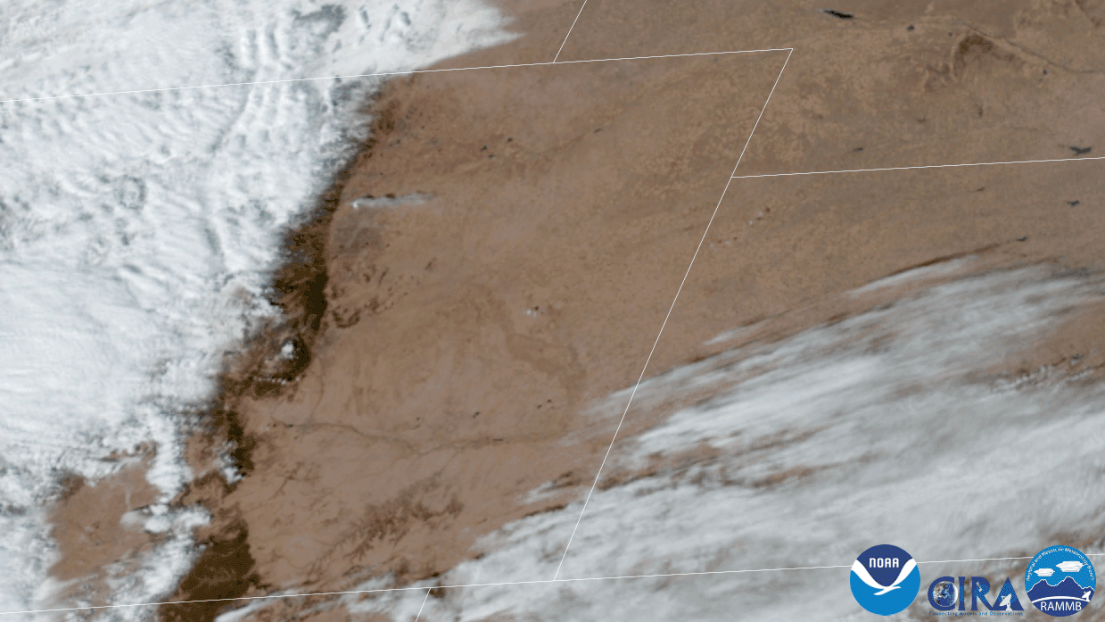
Visible satellite animation of the Marshall Fire on December 30, 2021.
The cold front and snow
The fire danger and high wind risk will lessen as the main bora cold front arrives around or just after sunset Wednesday evening. Chilly bora winds will spill across the northeast corner of Colorado and up along the Wyoming Border. Latest guidance suggests these post-frontal winds won’t greatly impact the Denver-Boulder area, staying further north and east. This is good news, but Wednesday evening and night will still be blustery.
We’re also tracking the potential for a few scattered rain and snow showers to come along with the front as it passes through the Metro area Wednesday evening. The precipitation chance east of the Mountains is somewhat uncertain due to several opposing lift factors, but there’s enough going on here to support at least a brief chance of showers across the lower elevations. Temperatures would be fairly warm at this time, so it’s set to be mostly rain for the lower elevations, though some areas could see snowflakes mix in. The primary window for a brief and gusty rain or snow shower comes from 5PM to 10PM on Wednesday. Best case, only a few hundreds of an inch of rain would be possible in this scenario and a dusting or less of snow for the luckiest spots.
Finally, the Mountains will see some snowfall as the system races across the state. Moisture is modest with this quick-moving storm, but orographics will be decent with strong northwest flow interacting with the terrain along the Divide and areas west. Northern Colorado will also be in the favorable left-exit region of the jet which should lead to locally heavy snow bands and/or squalls forming Wednesday evening, causing some sporadic whiteout conditions and overall challenging travel on mountain passes.
Still, the speed and moisture content of this storm will limit its snowfall potential in the High Country to just 3- 6″ along the Divide and to less than 1″ in the Foothills above 8000 feet. Boulder and Denver will see just a few spotty rain/snow showers with little to no accumulation.
Whew! That was a lot, but it’s a busy forecast! Let’s hope we can all just look back on tomorrow as a very windy day and nothing more. Stay weather-aware, prepare for planned and unplanned power outages, and please avoid any outdoor sparks or flames. Remember, we’re all in this together. Stay safe and check back for updates or subscribe.
Spread the word, share our crazy Colorado weather:
Go Premium, get all the perks.
Daily Forecast Updates
Get our daily forecast discussion every morning delivered to your inbox.
All Our Model Data
Access to all our Colorado-centric high-resolution weather model graphics. Seriously — every one!
Ski & Hiking Forecasts
6-day forecasts for all the Colorado ski resorts, plus more than 120 hiking trails, including every 14er.
Smoke Forecasts
Wildfire smoke concentration predictions up to 72 hours into the future.
Exclusive Content
Weekend outlooks every Thursday, bonus storm updates, historical data and much more!
No Advertisements
Enjoy ad-free viewing on the entire site.


You must be logged in to post a comment.