We discuss the forecast for snow on Thursday and how the weather pattern is shaping up heading into the holiday season.
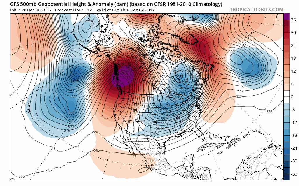
A weak upper-level shortwave will be passing overhead on Thursday. The 500 mb vorticity forecast map below shows the main trough digging across the Great Lakes into west Texas. Tomorrow’s weather feature is much more difficult to detect. There is barely any perturbation in the height lines. We have annotated the small trough axis across Colorado. It aligns nicely with a streak of vorticity (blue blip from the northeast to southwest).

GFS 500 mb vorticity map for Thursday evening. A weak trough axis passes across northern Colorado
This system overall is FAR from impressive. However, there is elevated moisture in the mid-levels of the atmosphere. Combined with the shortwave, this will fuel a few snow showers and flurries Thursday afternoon and evening, mainly across the Mountains and the higher elevations south of Denver.
The forecast sounding for the Denver Metro area Thursday evening looks troublesome for snow-lovers to say the least (shown below). For one, there’s no upslope at all (the northeasterly winds above 500 mb do not count!). There’s even going to be low-level downslope issues in Boulder County. Furthermore, the air from the surface up to about 775 mb (9,000 feet elevation) is very dry. Any snow that does fall from the clouds will likely sublimate before reaching the ground, or at most, fall as a few flurries.
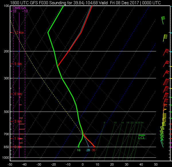
GFS model forecast sounding for Denver, valid at 5:00 PM Thursday. Dry air in the lower levels of the atmosphere and no upslope mean snow will be sparse.
For these reasons, we don’t foresee any accumulation for the Metro area, except a dusting in parts of the Foothills and maybe 1-2″ for the ski resorts. The timeframe for any flakes would be from 12PM to 10PM Thursday. Expect chilly temperatures in the 30’s under cloudy skies.
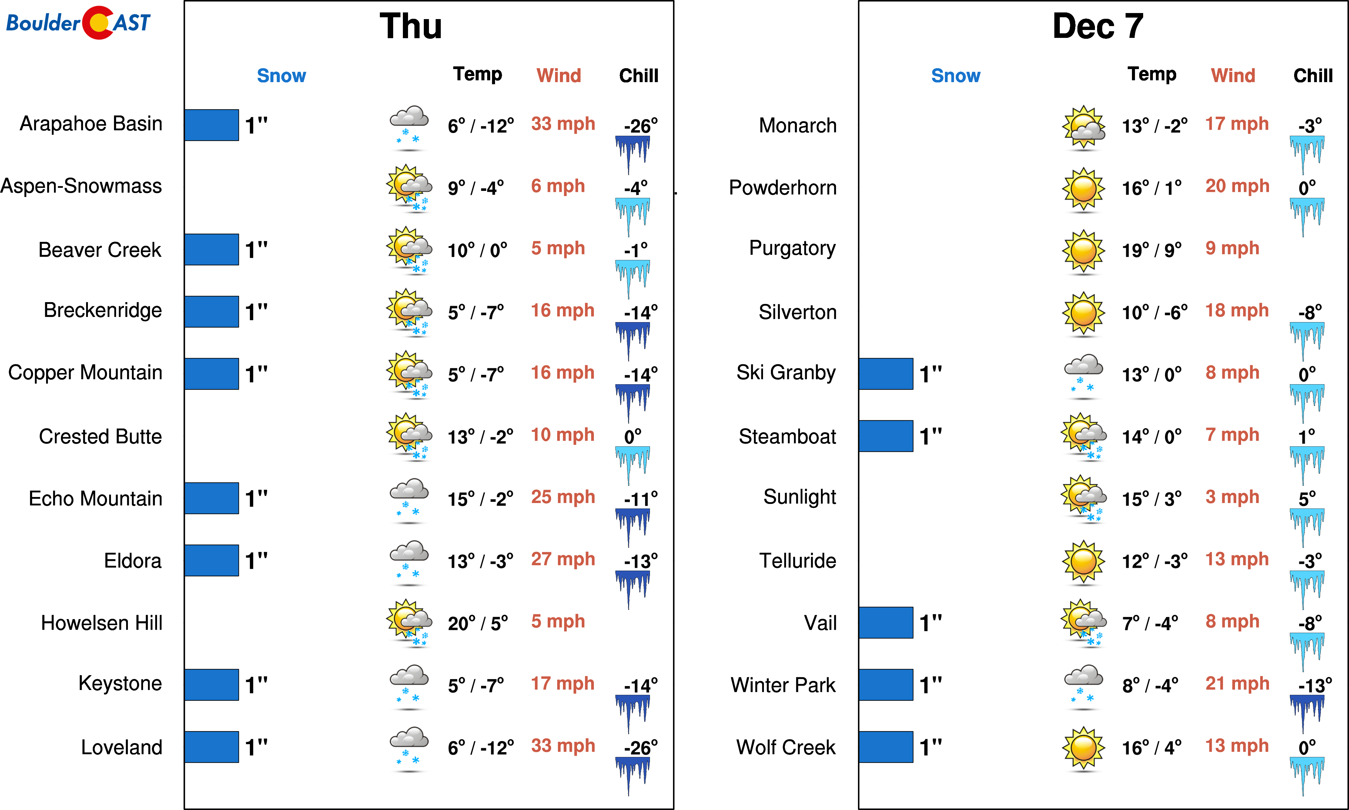
Bundle up if hitting the slopes on Thursday. There is a chance of light accumulation at a few resorts | Source: PowderCAST
White Christmas unlikely, but not impossible
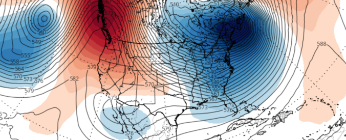
Models continue to indicate a persistent “dipole” pattern for the North American continent. The extremely pronounced ridge across California into Alaska, and the contrasting deep trough over the East Coast, are seen to persist in the animation below. This loop shows 500 mb heights from the GFS model, capturing today through the end of NEXT week.
GFS 500 mb height anomaly animation from today through the end of NEXT week (December 15).
As we have reiterated over the past few days to our Premium subscribers, this pattern puts Colorado in the middle-grounds of the “dipole”. The precipitation forecast map for the next week has the likeness of a doughnut sitting atop of California

GFS forecast total accumulated precipitation over the next eight days.
In fact, California is forecast to be one of the driest places on Earth over the next two to three weeks….right up there with the Saharan Desert in Africa!
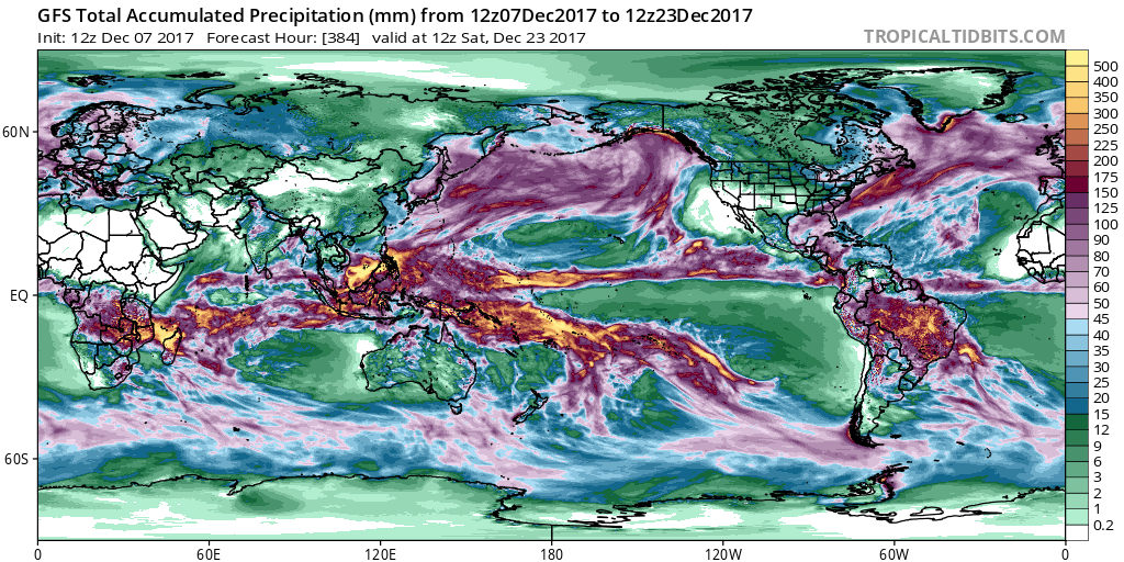
GFS forecast total accumulated precipitation over the next 17 days.
While it’s a near-certainty that dangerous wildfire conditions will stubbornly linger across California, our forecast here isn’t necessarily as set-in-stone. We most certainly won’t see any huge snow events in the foreseeable future, but the northwesterly jet stream will be nearby for an extended period, keeping the door open for frequent cold intrusions associated with the trough in the eastern United States. Under this pattern, any small meander westward could bring wintry conditions to the Front Range this time of year. Nothing significant, but a storm producing a few powdery inches is entirely possible. We’re not seeing any indication of this westward shift, however. We’re likely to remain dry, sunny, and seasonal for the next seven to ten days across Colorado (after Thursday’s brief shot of clouds/snow).
So far, this autumn has fulfilled the expectations from our outlook posted in early October. It’s been generally warm and windy, with sporadic small doses of snow. If you haven’t heard, a La Niña is now officially underway…
Hang in there….We still have more than FIVE months of crazy Front Range winter to go! Subscribe now to stay informed!
Help support BoulderCAST by sharing this post:


You must be logged in to post a comment.