After widespread snow and unseasonably cold weather on Monday, things quiet down for the midweek period with a nice warm-up headed to the Front Range. A secondary storm system will reach the area Thursday into Friday with Mountain snowfall ramping up again along with another chance of snow in the Denver area to close out the month of March. Read on for all the details.
Category: Winter Weather (Page 45 of 139)
These posts contain some discussion of the white stuff, whether it be mountain snow pack or a Front Range snowstorm.

Despite persistent and exceptionally cold weather, March has under-delivered on snow thus far with less than 2″ falling in Boulder since late February. More snow and cold is on the way Sunday night into Monday, but once again it looks to be another meager showing of snow. As of writing, uncertainty remains regarding exactly what will transpire with this event as a band of heavy snow may develop early Monday somewhere across the northern Front Range. Let’s take a look at the timing of everything, the most likely snowfall amounts, and the potential travel impacts as winter weather returns for the last Monday of March.
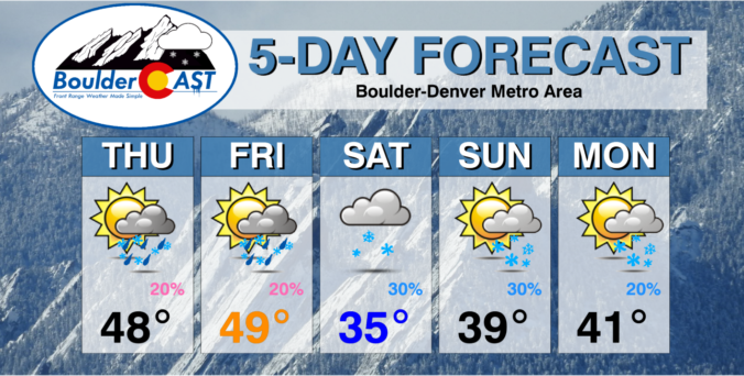

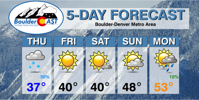
This week in Colorado weather will feature favorable upslope conditions across the Mountains into at least midweek, but mostly dry conditions and seasonal temperatures for the Plains. The deep moisture will bring hefty snow totals to the High Country over the coming days, with powder measured by the foot in many areas. Little if any precipitation will occur across the Denver Metro area, though Wednesday will bring our best chance with a stronger trough of low pressure moving through. The week ends with drier zonal flow but there are some signs of a possible snow event developing for the weekend.

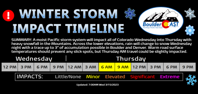
A potent atmospheric river event is ongoing across the southwestern United States right now including portions of western Colorado. After our warmest day in more than four months on Wednesday, this moist system will enter the picture for the Front Range Wednesday night with rain changing to snow across the Plains and Foothills as a cold front slides through. Though the best upslope will be south and southwest of Denver with this event, most everyone will see snowflakes amounting to a several inches in some places and just a dusting in others. Let’s take a look at the expecting timing of the change-over to snow, snowfall amounts, and the travel impacts in the works as winter weather returns to the Front Range.

This week’s weather will feature a resurgence of winter across the Front Range, but in typical fashion it will be immediately preceded by a few days of spring-like conditions including potentially our first 70-degree day of 2023. The bottom is set to fall out Wednesday night with rain changing to wet snow across the region. Though there is still some uncertainty due to the lead time, accumulating snowfall looks very likely for almost everyone in the Metro area. Read on for our complete outlook of the weather week ahead.

Live View of Boulder

Current Conditions

Live Radar

Recent Premium Posts

BoulderCAST Daily – Tue 06/02/26 | Storms Reload This Afternoon, But With Noticeably Less Bite
❄️ Monday delivered lots of hail to northeast Colorado, with one supercell tracking …
BoulderCAST Daily – Sun 05/31/26 | Dry and warm today but rain chances increase this week
🌦️ Overall dry and warm Sunday, though cannot rule out a very widely …
BoulderCAST Daily – Sat 05/30/26 | A stray shower today as most activity resides well east of Denver
🌦️ Spotty showers today, mainly well east of the Denver Metro area, where …
3-Day Forecast

Trending Content

© 2026 Front Range Weather, LLC