Category: Winter Weather (Page 46 of 139)
These posts contain some discussion of the white stuff, whether it be mountain snow pack or a Front Range snowstorm.
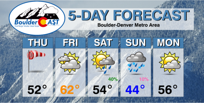
The week ahead will largely feature colder than normal temperatures with just minor chances for precipitation on several of the days. A frontal boundary will waver along and south of the Front Range through the week ahead leaving our area stuck in a pesky chilly airmass. A series of shortwave troughs will track through but for the most part remain north of our region leading to just limited rain/snow potential east of the Mountains. We detail all of this and more in our regularly-scheduled weekly outlook.
February 2023 was a chilly exclamation point on what was ultimately Boulder’s 2nd coldest winter in 30 years and the coldest since 2010. This very icy status was solidified by one of the most pronounced late February cold snaps on record. Here’s a quick and colorful graphical recap of our weather during February and how it relates to climatology.

The week ahead will indeed be an active one across the Front Range as an unsettled pattern remains entrenched across the western United States for the foreseeable future. This will spell out periods of gusty downslope winds, persistently cool temperatures and at least one or two chances for snowfall this week in our area, with the best shot coming Wednesday evening and night.
The sun is out but temperatures are way below zero this Thursday morning! Here’s a few highlights from the ongoing Arctic blast as snow wraps up and a slow warming trend begins across the Front Range.
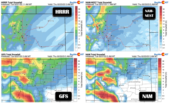
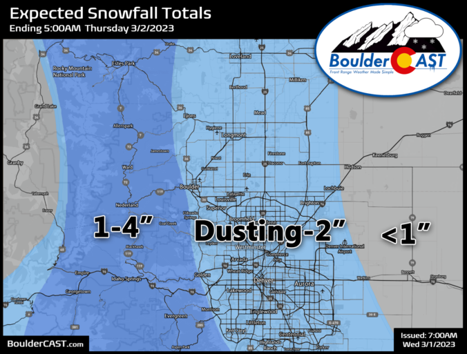
Premium Storm Update – Tue 2/21/23 7:00PM | Snow will arrives in a hurry pre-dawn Wednesday morning!
After a beautiful time in the 60s today, things are starting to look more stormy out there as the sun sets behind darkened clouds. It’s hard to believe, but snow will be falling in less than 12 hours in most areas with temperatures dropping into the single digits and teens in a flash! We run through a final check of the models looking at snow amounts, travel impacts and those cold temperatures.

Live View of Boulder

Current Conditions

Live Radar

Recent Premium Posts

BoulderCAST Daily – Tue 06/02/26 | Storms Reload This Afternoon, But With Noticeably Less Bite
❄️ Monday delivered lots of hail to northeast Colorado, with one supercell tracking …
BoulderCAST Daily – Sun 05/31/26 | Dry and warm today but rain chances increase this week
🌦️ Overall dry and warm Sunday, though cannot rule out a very widely …
BoulderCAST Daily – Sat 05/30/26 | A stray shower today as most activity resides well east of Denver
🌦️ Spotty showers today, mainly well east of the Denver Metro area, where …
3-Day Forecast

Trending Content

© 2026 Front Range Weather, LLC