
Despite persistent and exceptionally cold weather, March has under-delivered on snow thus far with less than 2″ falling in Boulder since late February. More snow and cold is on the way Sunday night into Monday, but once again it looks to be another meager showing of snow. As of writing, uncertainty remains regarding exactly what will transpire with this event as a band of heavy snow may develop early Monday somewhere across the northern Front Range. Let’s take a look at the timing of everything, the most likely snowfall amounts, and the potential travel impacts as winter weather returns for the last Monday of March.
Adding to March’s meager snowfall
As we head into the final days of March, it’s clear this month has been very light on snowfall (and more importantly, moisture). Boulder has received only 1.7″ of snow month-to-date, which is more than a foot below the monthly average (15.8″) and the monthly median (16.3″), respectively. This small amount of snow isn’t record setting, if that crossed your mind — just since 2011 there have been three other years donning less snowfall in March:
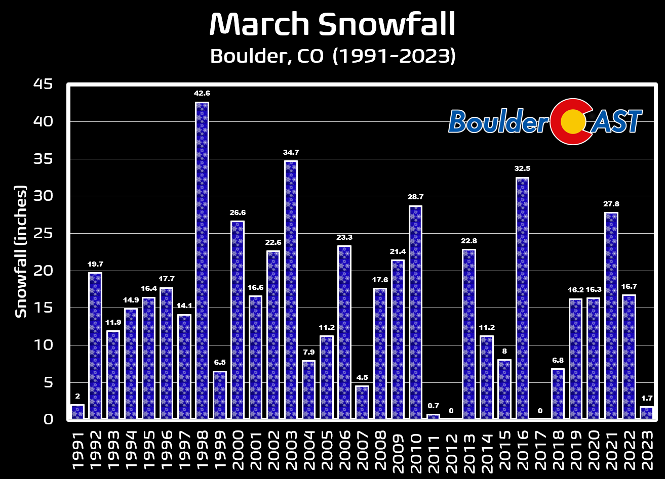
Perhaps most remarkable aspect of the 1.7″ of snow that has fallen this March is the fact that it was generated by five different snowfall events, each more dissatisfying than the last.
- March 2nd: 0.5″
- March 9th: 0.2″
- March 16th: 0.5″
- March 22nd: 0.2″
- March 25th: 0.3″
- ———————-
- TOTAL 1.7″
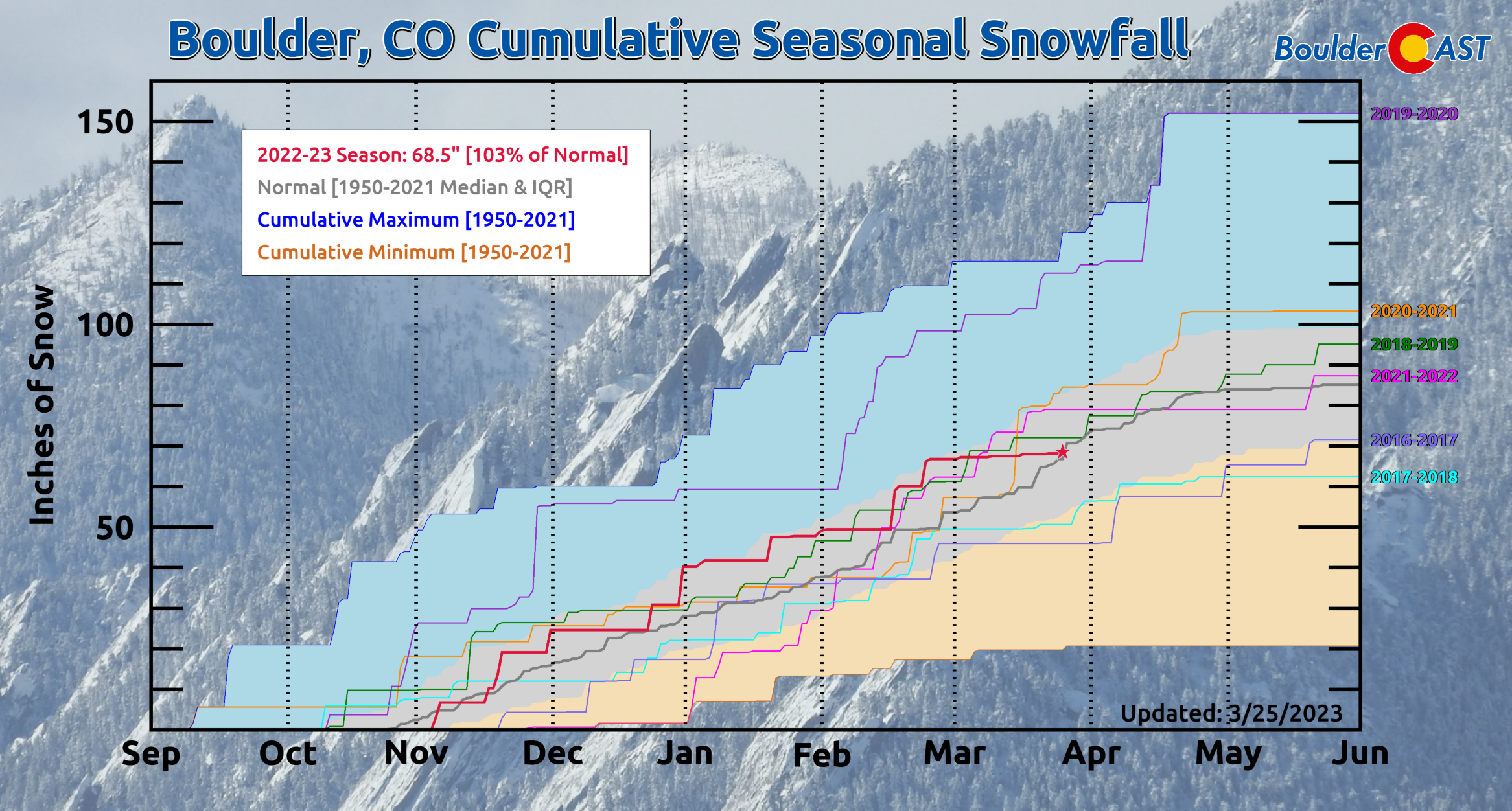
With this recent extended lull in snowfall, what was once a happy-go-lucky snow season with well above normal snowfall has waned back into just a “normal” snow season. Boulder now has 68.5″ of snow for the 2022-23 season which is just 3% above normal. All hope is not lost at this point —- a typical season would see another 17″ of snow dump between now and the end of May.
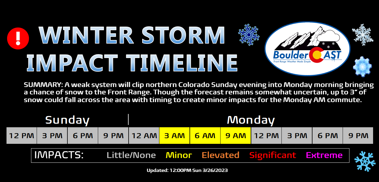
There is indeed more snowfall in the works as we close out the month of March — though it is far from anything substantial. Today’s brief discussion will focus on the imminent threat of snowfall which develops Sunday evening into Monday. Just be aware that there is a secondary chance possible later in the week which we will cover in tomorrow’s weekly outlook.

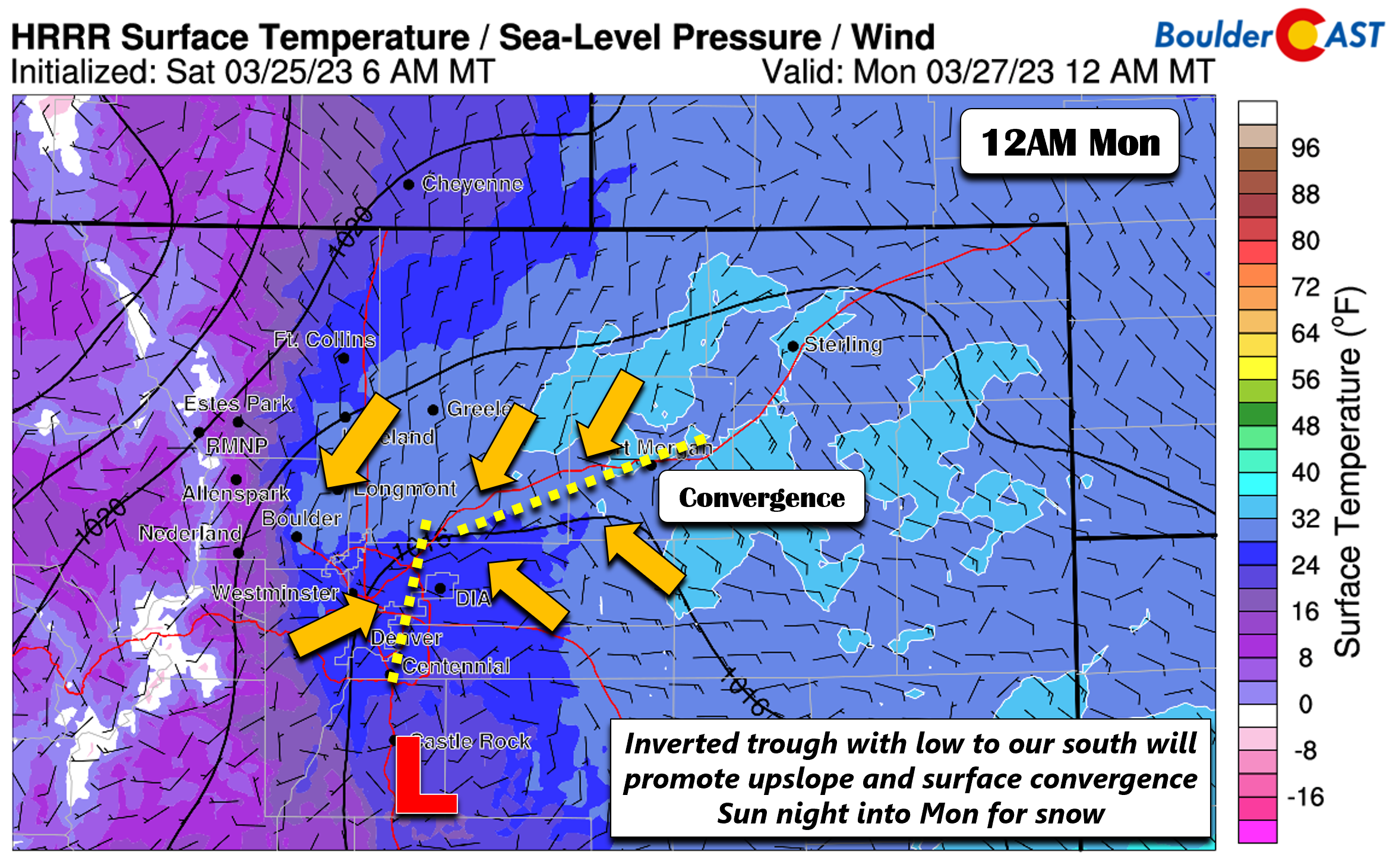
For now, the meat and potatoes of the snow chance Sunday night will be fueled by a shortwave trough which scrapes across northern Colorado over the next 24 hours bringing with it a period of weak upslope, elevated moisture, and converging winds along a frontal boundary.
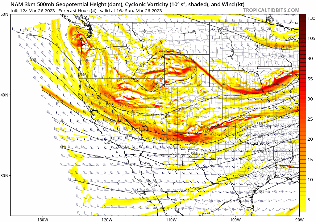
It is the latter ingredient that continues to make this a challenging and uncertain forecast — the presence of low-level convergence across the Front Range could spawn an arcing band of moderate to heavy snowfall across the area overnight into Monday morning as moist southeasterly winds ride up and over colder northwesterly winds. Models continue to struggle pinpointing where this favorable setup will occur, whether it be closer to the Foothills or further out east across the Plains.
The latest HRRR model run below shows this potential arcing convergence band nicely, though it mainly hits areas from Interstate 25 eastward early Monday with 2-4″ of snow (including DIA),

This is just one model’s prediction for what is ultimately a fine-scale feature that is by its very nature hard to predict. The RAP model had this band forming a bit further west hitting Boulder, Longmont and Broomfield head on with 2-4″ of snow.
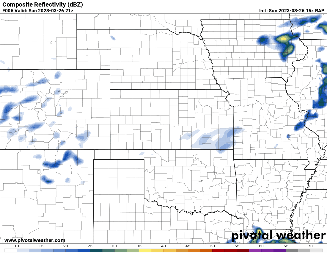
The net result here is a tricky snow forecast for what will transpire tonight and early Monday, even in these final hours. Several models continue to advertise a 2-5″ type of snow event for the Metro area, while others have next to nothing.

We think the eventual outcome will be somewhere in the middle, with convergence and upslope coming together for a band of snow overnight which will approach 1″ per hour rates in spots. Exactly who gets the best snow remains uncertain. Our snowfall forecast map shown below essentially broad-brushes the Boulder-Denver area with a dusting to 3″, with a better chance of seeing at least 1″ in the Foothills where it will be colder and snow showers arrive earlier. There could certainly be some locally higher amounts wherever the band hits. If that occurs we believe it would probably land in the northern Front Range — somewhere between Broomfield, Greeley, DIA and Fort Morgan. Again, we continue to stress this particular forecast is unusually uncertain! However, fear not — even the worst case scenario would bring only 4 to 5″ for a few locales — nothing crippling.

Light snow showers begin as early as this evening (mainly in and near the Foothills) but the best chance comes overnight into Monday morning when the upslope and convergence briefly align for a handful of hours.
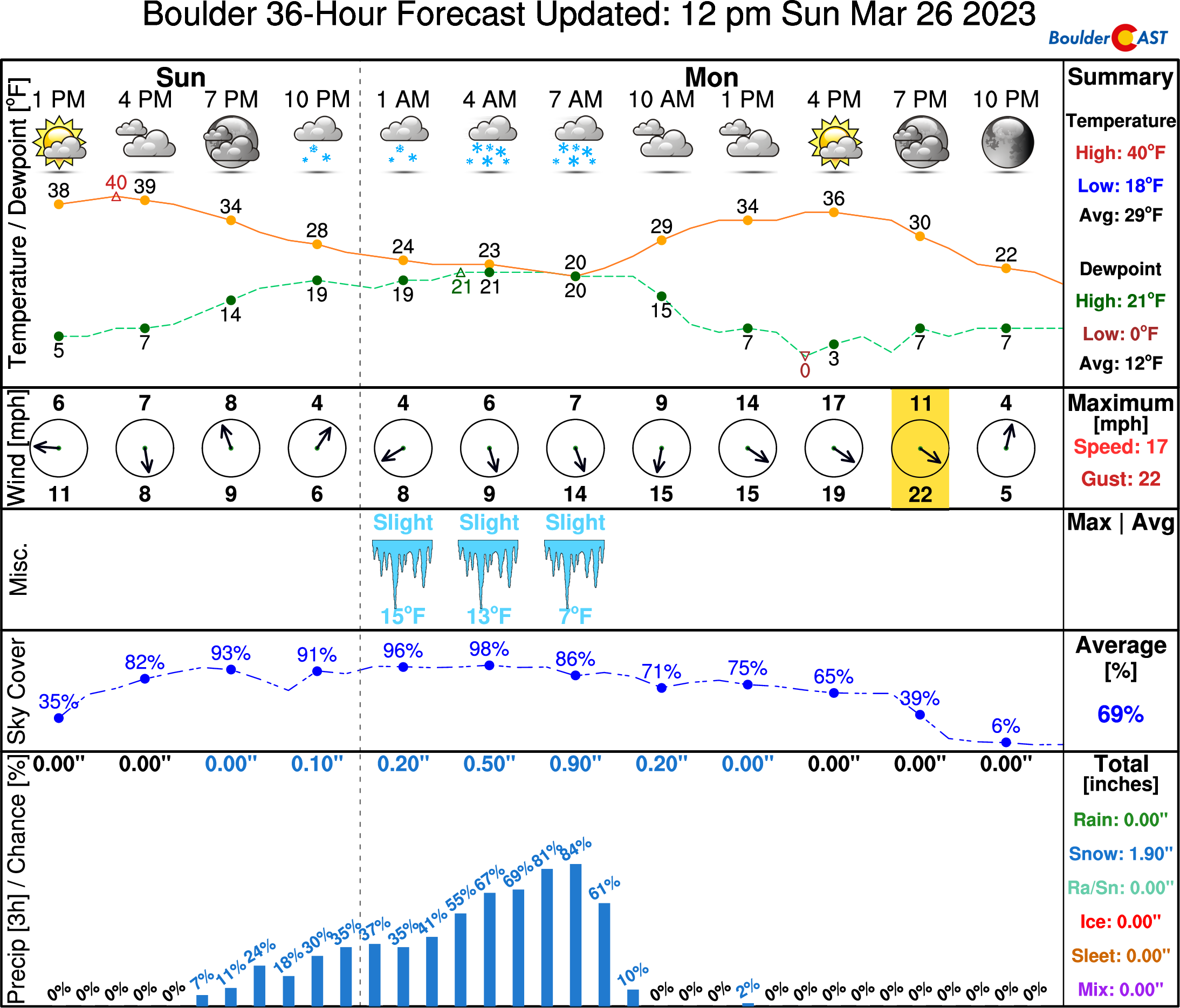
Expect Monday morning temperatures around 20 degrees with some potential slick spots out there for the commute. The trend of exceptionally cold weather will continue with highs only the 30s again Monday — some 25°F below normal. Tomorrow we’ll talk more about the weather for the rest of the week. Enjoy the few remaining hours of your weekend!
Get BoulderCAST updates delivered to your inbox:
Enjoy our content? Give it a share!


You must be logged in to post a comment.