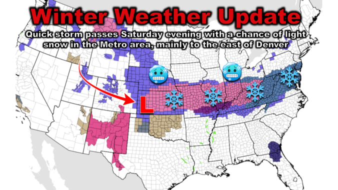
Shallow cold air has surged back into the Front Range overnight, causing temperatures to tumble and dense freezing fog to form. While the higher elevations enjoy sunshine and milder temperatures Saturday, the Plains remain in the 20s. An incoming storm system will bring light snowfall and reinforce the cold air Saturday evening, with the best chances of accumulating snow east of DIA and towards Kansas and Nebraska. We discuss just how cold it will be this weekend, the timing of the snow, and how much to expect. We also look ahead to our next and better chance of snow coming early in the upcoming week.
Category: Winter Weather (Page 15 of 134)
These posts contain some discussion of the white stuff, whether it be mountain snow pack or a Front Range snowstorm.
Northwest flow aloft will keep the start of 2025 cool and largely dry for the lower elevations. However, ridging aloft will allow for milder temperatures by the latter part of the week. The High Country will cash in on more snow Thursday and Saturday, perfect for skiers looking to start the New Year right. We also recap the brief high wind event that occurred on Monday.

Exactly three years to the day since a thousand Boulder County homes burned to the ground in the Marshall Fire, the Front Range is bracing for a similar yet tamer weather event on Monday, with high winds, elevated fire danger, and Mountain snow on the way. A quick-moving storm system will bring widespread gusts over 40 MPH to the area, creating conditions favorable for the spread of wildfires across most of drought-stricken northeast Colorado. While Monday is not expected to be as nearly bad as that fateful day three years ago, we urge you to remain vigilant to prevent any fire ignitions on Monday. We discuss the latest forecast, including how the developing conditions for Monday compare and contrast to those back in 2021.
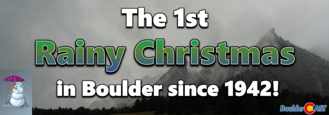
Yesterday on Christmas Day, a deluge of rain dumped on the western Denver Metro area during the afternoon and evening, but amazingly not a single snowflake fell across most of the lower elevations as temperatures remained several degrees too warm for frozen precipitation. This led to the first “Rainy Christmas” that most of us have ever experienced. As expected, a white Christmas was enjoyed by those in the higher terrain where temperatures were colder. We recap the holiday raindrops and snowflakes, including a look at just how rare Christmas rain really is and if it will be the new normal in a warming climate.
After days and days of warm and dry weather, things in the Front Range are taking an interesting turn right in time for Christmas. A trough of low pressure is moving into the Four Corners area right now with a mix of clouds and sunshine out ahead of it. Later in the day, a cold front will move through from the northeast leading to scattered showers spawning across the western Metro area. Mostly rain is expected for the lower elevations which will be largely too warm, but Foothills communities could pick up a few slushy inches this evening to nab a white Christmas after all! We discuss a bit of Christmas climatology for Boulder, the weather setup at hand today, the latest timing of the rain/snow showers, and just how much accumulation may fall this evening and where.

Hint: All of the clues are related to Boulder, Denver, and/or Colorado weather. OK, well most of the clues…
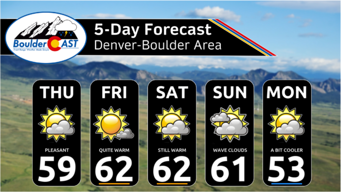
This week’s weather in the Front Range will see a shift from the recent unseasonably warm temperatures to cooler conditions, with periodic light snow expected in the Mountains throughout the week. While a white Christmas is unlikely for the Denver Metro area, there will be a slight chance of rain or snow showers Wednesday evening and night. The late-week period will remain active with several disturbances bringing more light snow to the Mountains, but the lower elevations around Boulder and Denver will stay mostly dry with mild temperatures. We also look ahead to next week when we’ll likely see a longer-term transition to much colder and snowier weather for the New Year.

Live View of Boulder

Current Conditions

Live Radar

Recent Premium Posts

BoulderCAST Daily – Sun 01/11/26 | A mild Sunday with readings reaching the 50s
🌤️ Mild & Melty Sunday: Light winds and patchy clouds, with lingering snowpack …
BoulderCAST Daily – Sat 01/10/26| Widespread sunshine and moderating temperatures this weekend as our recent snow melts off
🌤️ Calm Saturday: Winter storm systems have departed the state, leaving behind a …
BoulderCAST Daily – Fri 01/09/26| Snow ends quickly this morning with a quieter weekend in store
❄️ Overnight snow bands: A second push of upslope after midnight sparked narrow …
3-Day Forecast

Trending Content

© 2026 Front Range Weather, LLC