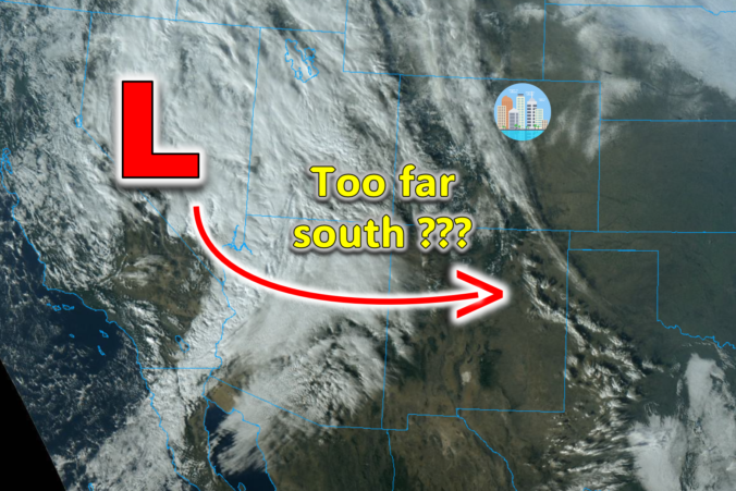
The weather pattern is shifting as we speak across the West and with several southern-track storms set to impact our area in the coming week or so. The first arrives on Thursday, but unfortunately it is coming in a bit too far south with things largely bypassing the Denver Metro area. Still there will be some amount of wintry weather to end the week. Let’s take a look at the latest forecast for not only the storm knocking on the door, but the next one gearing up for late in the weekend.
Category: Powdercast (Page 4 of 22)
Forecasts focused on the many ski resorts of NE Colorado.
We’ve got a few more mild days ahead to end the work week, but as promised, winter will return for the holiday weekend in what is shaping up to be a challenging forecast indeed. We are finally starting to see better agreement in the various weather models, but things are still far from certain. Our weather will begin to trend downhill on Saturday with cooler temperatures and a chance of rain showers. Saturday night rain will change to snow with snow accumulation likely for all heading into Christmas Eve. Exact snowfall amounts and the timing of everything are still being worked out, but here’s our latest thoughts on the approaching holiday winter storm.
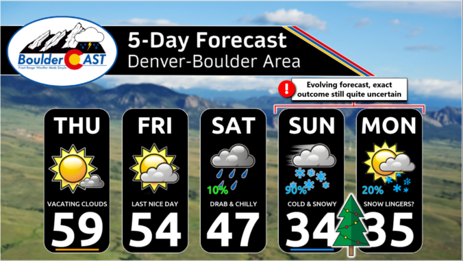
Most of the week ahead in the Front Range will feature dry weather with well above normal temperatures for early December. However, we are closely tracking our next storm system set to arrive on Friday with much colder temperatures returning alongside a good chance of snowflakes. Read on for the latest details on what should be yet another spirited week in Colorado weather!
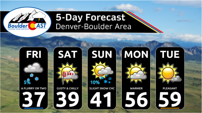

This week will offer up the most exciting weather we’ve had across the Front Range in a long time. We’ve got rain showers, high winds, freezing drizzle, bitter cold temperatures and accumulating snow headed our way, but there will still be a few beautiful days mixed in as well. Read on for the latest details on what should be a interesting week in Colorado weather!
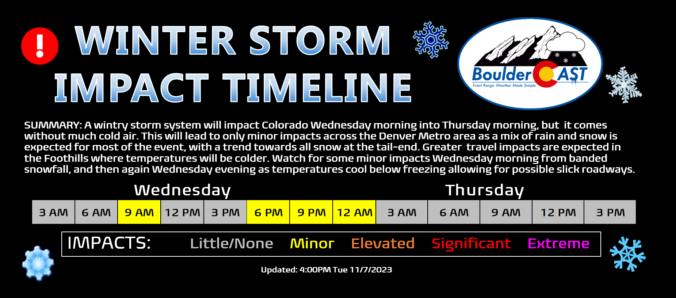
A wintry storm system will impact Colorado Wednesday morning into Thursday morning, but it’s not bringing much cold air to the party! This will lead to only minor impacts across the Denver Metro area as a mix of rain and snow is expected for most of the event, with a trend towards all snow at the tail-end as precipitation will be wrapping up. Greater travel impacts are expected in the Foothills where temperatures will be colder and up to 8 inches of snow may accumulate. We discuss the timing of the rain and snow, the expected snowfall totals for everyone and when travel may be most impacted.
What a wonderful weekend it was across the Front Range culminating with sunshine and record high temperatures on Sunday! The warmth will continue for just a couple more days here before a midweek weather system will usher in much colder temperatures alongside the threat of rain and snow, including potential heavy snow in the Foothills. Uncertainty remains elevated for this storm overall, but change is definitely headed this way. Read on for the latest details.
It’s been over six months now, but winter weather is finally set to return to the Front Range this weekend as the coldest air of the season shows up alongside several inches of fluffy snow. An interesting weather setup will have a stalled jet streak directly over Colorado Saturday evening seeding a lengthy period of scattered heavy snow bands. Snowfall amounts, while still somewhat uncertain, have trended upward and some of us could see up to a foot of snow this weekend! Read on for our latest thoughts on the storm, including when the heaviest snow will be around, how much accumulation to expect and just how cold it will get. We also reveal the entries to our 2023 First Snowfall Contest since a winner for that will surely be crowned this weekend!

Live View of Boulder

Current Conditions

Live Radar

Recent Premium Posts

BoulderCAST Daily – Sat 01/10/26| Widespread sunshine and moderating temperatures this weekend as our recent snow melts off
🌤️ Calm Saturday: Winter storm systems have departed the state, leaving behind a …
BoulderCAST Daily – Fri 01/09/26| Snow ends quickly this morning with a quieter weekend in store
❄️ Overnight snow bands: A second push of upslope after midnight sparked narrow …
BoulderCAST Daily – Thu 01/08/26 | Snow develops today but still some uncertainty, amounts have been lowered
❄️ Snow develops today: Snow develops today, but uncertainty still lingers with two …
3-Day Forecast

Trending Content

© 2026 Front Range Weather, LLC