Category: Monsoon (Page 8 of 12)
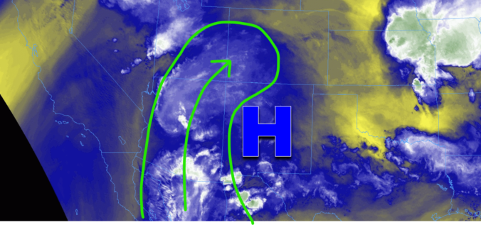
This week’s weather in Colorado will be dominated by a potent ridge of high pressure setting up shop across New Mexico. Although chances of storms will exist for Monday and Tuesday, model guidance shows better agreement for more numerous thunderstorm activity during the latter part of the week as a few weak fronts move into the region and moisture levels increase across the Front Range. High temperatures will be close to record values early in the week, but trend downward slowly by week’s end. Read on for more details.
After a mostly quiet and warm weekend, things will more-or-less remain unchanged for the first full week of June. Temperatures will stay warm to hot with only a small chance of rainfall this week. We’ve managed to dodge the nineties so far in 2024, but that bout of good fortune will run out later this week with multiple days soaring above 90 degrees. Read on for all the details.
August 2023 ended up warmer and wetter than normal in Boulder — an uncommon pair of outcomes indeed. The summer monsoon failed to produce consistent precipitation across the state throughout the whole month (woefully dry in the middle), but most areas made out alright with drought still thankfully absent from eastern Colorado. The month had 14 90-degree days bringing the total count to 30 days year-to-date. Elsewhere, a DVD-sized hailstone that fell in far eastern Colorado was confirmed to be a new state record. Here’s a quick and colorful graphical recap of our weather during August and how it relates to climatology.
A very typical, though somewhat boring late-summer week will unfold across the Front Range as the monsoon wraps up and we await the seasonal arrival of the polar jet stream. Our best chance of rain this week comes immediately on Monday as afternoon thunderstorms rock the area. Drier and hot weather will return in the days to follow, however. Late-season monsoon moisture will reach the area Friday into the upcoming weekend, but the heat will be going nowhere.
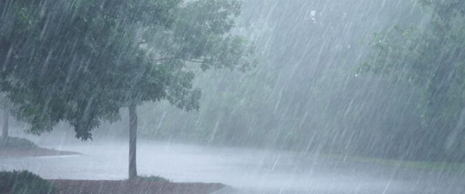
A stark change in our weather is set to take hold for Friday as we move from seemingly never-ending summer heat to a much cooler and rainy setup that will bring with it a significant flood risk to the Front Range. The remnants of Tropical Storm Harold and a strong Canadian cold front will align almost perfectly over the area late Friday into Saturday with more than 1″ of rainfall possible and even more locally. In this update we discuss the latest timing of everything, the temperature nose dive, rainfall amounts, and which areas are at greatest risk to see flooding.
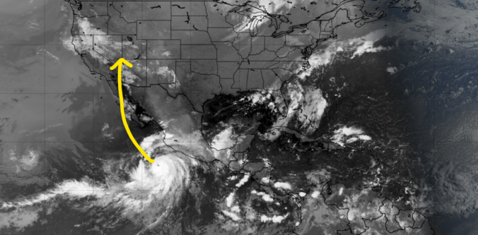
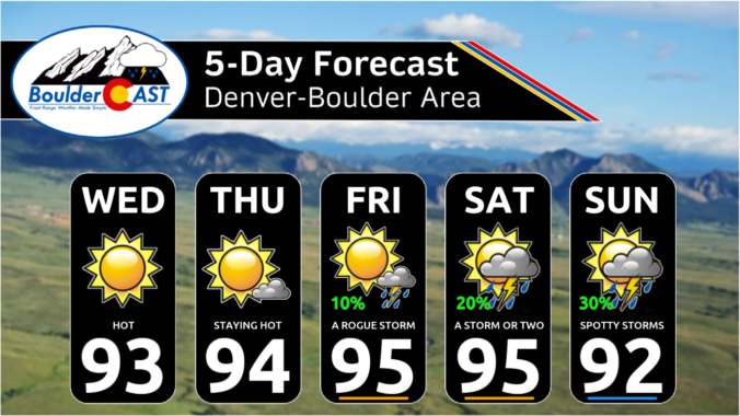
A ridge of high pressure will remain in control of Colorado through the extended and even intensifies this weekend keeping us mostly dry and hot. The best chance of rain in the pipeline comes on Friday, but only limited rainfall is expected from storms due to a lack of moisture. Additionally, the remnants of major Hurricane Hilary in the Eastern Pacific will arrive to the USA this weekend but stay well to the west of Colorado unfortunately (boo!). Things dry out further this weekend into early next week as temperatures once again make a run towards triple digits in the Denver Metro area.

Live View of Boulder

Current Conditions

Live Radar

Recent Premium Posts

BoulderCAST Daily – Sat 05/02/26 | A pleasant and warm first weekend in May
☀️Warming up for the first weekend in May, with upper 60s to near …
BoulderCAST Daily – Fri 05/01/26 | Warming up this weekend
🌡️ Warming up this weekend, from the upper 50s-60 today to the upper …
BoulderCAST Daily – Tue 04/28/26 | Staying cool with a couple showers, the late-week storm is still the main event despite trending south
🌧️ Morning wave = main show, with light rain showers and Foothills wet …
3-Day Forecast

Trending Content

© 2026 Front Range Weather, LLC