
Overnight severe storms produced tennis ball-sized hail in parts of eastern Boulder County, acting as an appetizer for what will unfold later today as the greatest risk of severe weather in years may develop across the Denver Metro area. Low clouds lingering during the morning may delay the severe weather ignition today, but huge hail, damaging winds and a few tornadoes are still in the cards for the afternoon and early evening hours for some area. After the severe weather threat diminishes, soaking rain becomes the story Thursday into early Friday with areal flooding possible.
Category: Forecast (Page 54 of 169)
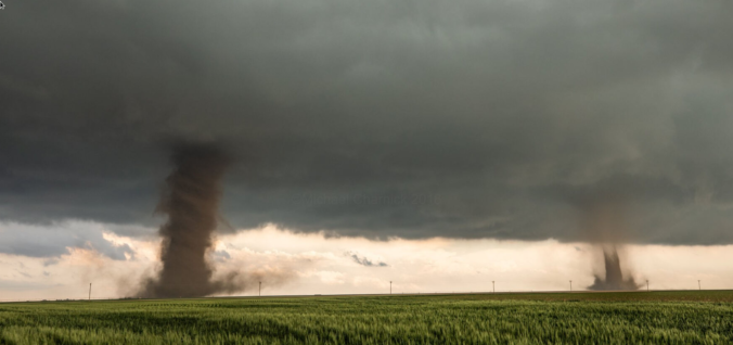
One of the most widespread Front Range severe weather outbreaks in recent memory is taking shape on Wednesday, though we still have some concerns. Two-inch hail, damaging winds and a few tornadoes are likely across eastern Colorado on Wednesday. Before that however, there will be another more uncertain bout of severe weather Tuesday night for the northern Front Range with big hail the main concern. Let’s get into this two-folded complex forecast!

After a few warm and quiet days, big changes arrive midweek as a southern-track storm system targets the Front Range. Initially we’ll be in the warm and unstable sector with the first severe weather outbreak of 2023 for Colorado taking shape on Wednesday. By late week, the main storm system will slowly move across the state inducing a prolonged period of upslope and soggy conditions across our area. What type of severe weather should we expect on Wednesday and how much rain (and snow) will fall this week? Let’s take a look.
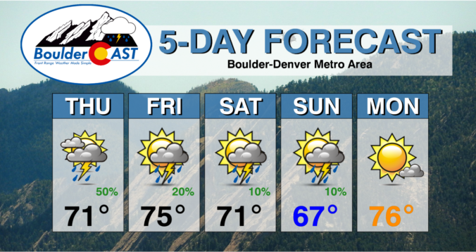
A large Omega Block pattern will be in place through much of the week ahead with ridging over the central Plains and troughs on either side — one along the West Coast and another over the Northeast. Above normal temperatures with highs in the 70s are expected for the Front Range under this setup, but it will come with the threat of afternoon showers and storms more typical of summertime. Read on for the details on when we think the best chance of wet weather will be along with our predictions for the weekend.
Another wave of precipitation will accompany a cold front racing into the Front Range from the north Thursday night with rain changing to snow across the Denver Metro area. This precipitation will be joined by strong dynamics and northerly flow, making for a gusty and unsettled evening ahead, with some grassy accumulations possible across the lower elevations as snow mixes in late for some. This storm will largely favor areas south of Interstate 70, with the northern Front Range including Boulder not expected to see much. Let’s take a look.

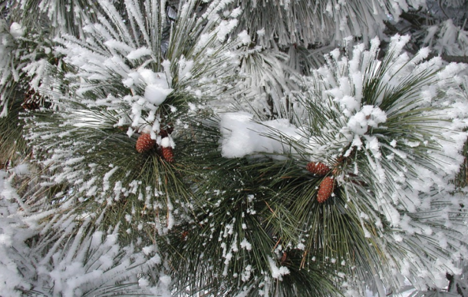
A powerful low pressure system remains on-track to impact the Front Range Tuesday afternoon into Wednesday with several hours of nearly perfect upslope in the works. While there has been a slight southward shift in the storm’s track, we still anticipate widespread soaking rain across the lower elevations and heavy wet snow in the Foothills, including some thunder thrown into the mix. Travel will become extremely difficult Tuesday evening west of town with snowfall rates of 1 to 3″ per hour. Finally, while this event will be almost exclusively just cold rain across the Plains, we may see a little wet snow in the far western and southern Metro area. Read on for all the details.
The last week of April will undoubtedly be an interesting one weatherwise across the Front Range as a potent spring storm bears down on Colorado in the coming days. While we still have some concerns about the storm’s track and exactly how low snow levels will come, this will be a classic upslope event with impacts ranging from thunderstorms to soaking rain to heavy wet snow for our area. Furthermore, there will also be another smaller but colder storm late in the week with accumulating snow chances. The Front Range forecast this week sure is busy! Let’s get into it.

Live View of Boulder

Current Conditions

Live Radar

Latest Smoke Forecast

Recent Premium Posts

BoulderCAST Daily – Wed 07/15/26 | The Ridge Rules the Rockies as Hot, Dry Pattern Holds Firm
🔥 Heat dome setup continues — A strong, stationary 500 mb ridge keeps …
BoulderCAST Daily – Tue 07/14/26 | The Front Range Continues to Bake Under Expansive Ridge
🔥 Heat streak continues — Boulder hit 97°F for the third time in …
BoulderCAST Daily – Sun 07/12/26 | Hot weather for a good chunk of the coming week
🥵 🔥 Heat for a good chunk of the week: Upper 90s through …
3-Day Forecast

Trending Content

© 2026 Front Range Weather, LLC