


Category: Forecast (Page 49 of 169)
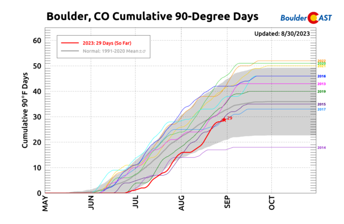
A very typical, though somewhat boring late-summer week will unfold across the Front Range as the monsoon wraps up and we await the seasonal arrival of the polar jet stream. Our best chance of rain this week comes immediately on Monday as afternoon thunderstorms rock the area. Drier and hot weather will return in the days to follow, however. Late-season monsoon moisture will reach the area Friday into the upcoming weekend, but the heat will be going nowhere.

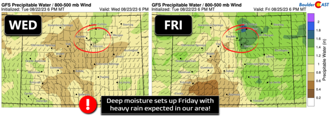
A stark change in our weather is set to take hold for Friday as we move from seemingly never-ending summer heat to a much cooler and rainy setup that will bring with it a significant flood risk to the Front Range. The remnants of Tropical Storm Harold and a strong Canadian cold front will align almost perfectly over the area late Friday into Saturday with more than 1″ of rainfall possible and even more locally. In this update we discuss the latest timing of everything, the temperature nose dive, rainfall amounts, and which areas are at greatest risk to see flooding.
The week commences on the hot and dry side as a very strong and anomalous ridge over the central United States keeps much of Colorado locked into a scorching heatwave. Remnants from a tropical cyclone over the western Gulf of Mexico may influence our region later in the week as it interacts with a southward moving cold front. This should favor cooler temperatures and increasing chances for thunderstorms by the latter part of the week into the weekend. Read on for all the details of yet another semi-active weather week for us.
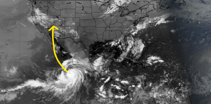
A ridge of high pressure will remain in control of Colorado through the extended and even intensifies this weekend keeping us mostly dry and hot. The best chance of rain in the pipeline comes on Friday, but only limited rainfall is expected from storms due to a lack of moisture. Additionally, the remnants of major Hurricane Hilary in the Eastern Pacific will arrive to the USA this weekend but stay well to the west of Colorado unfortunately (boo!). Things dry out further this weekend into early next week as temperatures once again make a run towards triple digits in the Denver Metro area.
The week begins on the cooler side, but don’t be fooled! Hot weather, including potential record-breaking heat, is lurking right around the corner as temperatures return to the 90s by Tuesday and stay there the rest of the week. Rainfall will also be hard to come by during this toasty stretch. Let’s take a look at the hot and dry weather week ahead…
The week ahead will remain somewhat cooler and drier than normal as a weak trough stays entrenched and monsoon moisture continues to be difficult to come by. However, a favorable setup for severe thunderstorms will exist across northeast Colorado early in the week with hail the main risk. Overall temperatures will stay mostly below normal in the days ahead but they will trend back towards 90 degrees by week’s end.

Live View of Boulder

Current Conditions

Live Radar
Latest Smoke Forecast

Recent Premium Posts

BoulderCAST Daily – Tue 07/14/26 | The Front Range Continues to Bake Under Expansive Ridge
🔥 Heat streak continues — Boulder hit 97°F for the third time in …
BoulderCAST Daily – Sun 07/12/26 | Hot weather for a good chunk of the coming week
🥵 🔥 Heat for a good chunk of the week: Upper 90s through …
BoulderCAST Daily – Sat 07/11/26 | Here comes the heat!
🥵 Heat start today: Upper 90s start today and continue well into next …
3-Day Forecast

Trending Content



© 2026 Front Range Weather, LLC