Category: Climatology (Page 22 of 63)
These posts contain information about the long-term weather patterns of Boulder County. Potential topics may include 30-day weather outlooks, El Nino/La Nina, and seasonal forecasts. You will find less about the day-to-day weather, with more focus on longer trends and patterns.
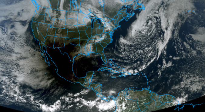
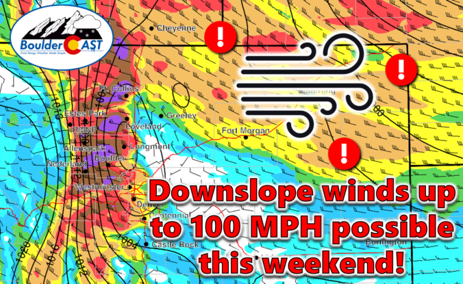
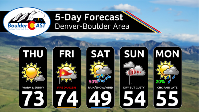
An exceptionally strong spring storm is approaching Colorado which will develop into a big ol’ blizzard in the coming days. However, unlike the last few storms which have been direct hits on the Front Range, this one will track further north leading to more wind than precipitation in our area. After a warm and gusty Friday with high fire danger, the incoming storm will bring colder temperatures and a brief chance of rain/snow showers on Saturday. The biggest impacts from this system, though, will come in the form of prolonged damaging downslope winds. We take a look at the large-scale atmospheric setup and discuss the potential snowfall amounts and which unlucky areas have a chance at wind gusts up to 100 MPH this weekend.
The week starts off on the chilly side with rain/snow showers for our Monday thanks to a passing area of low pressure. Snowfall amounts will be rather limited by marginal temperatures, with the best chance for a few inches of accumulation being in the Foothills. A trend toward above normal temperatures will take over by mid to late week as an omega blocking pattern sets up over the central United States. We are watching the potential for not only fire weather concerns late in the week but also a rain/snow chance for the weekend as another strong storm system moves in. Let’s take a look!
After a solid dump of springtime snow Sunday night, including widespread thundersnow, things will turn quiet for the week ahead with temperatures trending from downright chilly back to t-shirt weather by week’s end. We recap last night’s snowstorm, check the snowfall totals, and detail the Front Range forecast for the next seven days. Let’s dive in!
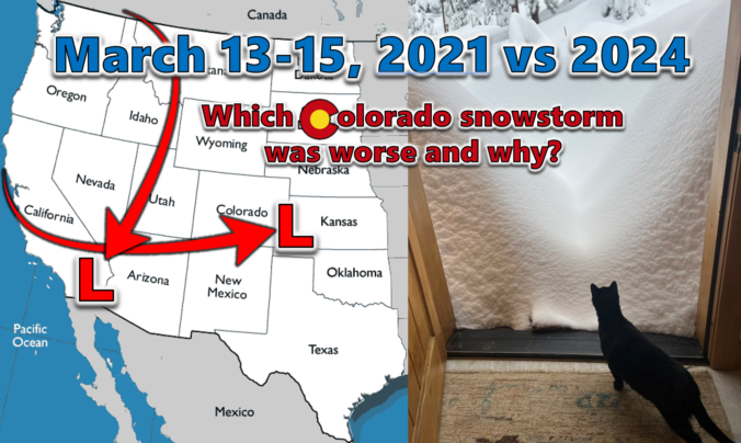
Last week’s dumping of wet snow in the Front Range occurred three years to the day after our most recent significant snowstorm back in March of 2021. We do a comparative analysis between these two epic mid-March snowstorms, examining their distinct storm tracks, the meteorological factors contributing to their varied snowfall production, and discuss their differing forecast hype. We also explore their respective snow totals and distribution across the Denver Metro area, including a detailed account of how these two snowstorms were able to make Front Range history exactly three years apart despite being so fundamentally different.
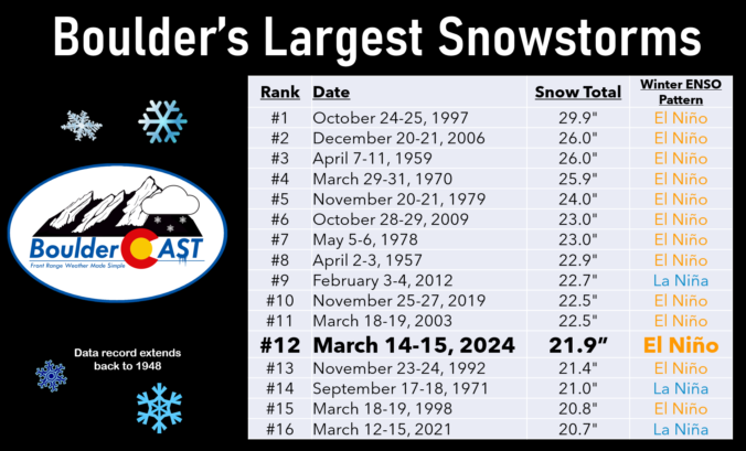
As promised, a well-advertised spring-like snowstorm delivered the goods to (almost) the entire Front Range this week with over four feet of snow falling in the Foothills and up to 2 feet across the lower elevations. We take a look back at this odd, moisture-infused winter storm, discussing how the difficult forecast evolved during the lead up and ultimately how much rain and snow pummeled the area.

Live View of Boulder

Current Conditions

Live Radar

Recent Premium Posts

This Weekend in Colorado Weather: Red Flag Conditions Thursday, a cooler weekend ahead, and chances increase for a record late first snowfall
🔥 Windy with fire danger Thursday: Gusts of 20–30 MPH across the Metro …
October 2025 Graphical Weather Review: A warm & dry month that prolonged the growing season, delayed our first snow
October 2025 was definitively warm and dry throughout the Front Range with the …
BoulderCAST Daily – Wed 11/05/25 | Relatively cooler today, but far from cool by November standards
🌡️ Cooler but still mild today: A weak cold front has pushed south, …
3-Day Forecast

LATEST SMOKE FORECAST

Trending Content


© 2025 Front Range Weather, LLC