Friday delivered one of those classic Colorado curveballs. The storm showed up fashionably late, then hit harder than expected once it finally got going. It left behind a fast‑melting blanket of spring snow and cleared out almost as quickly as it arrived. In today’s update, we break down the wild midday burst of snow, take a look at how the forecast held up, and highlight why the real headline may have been what happened — or didn’t happen — after the flakes stopped.
F
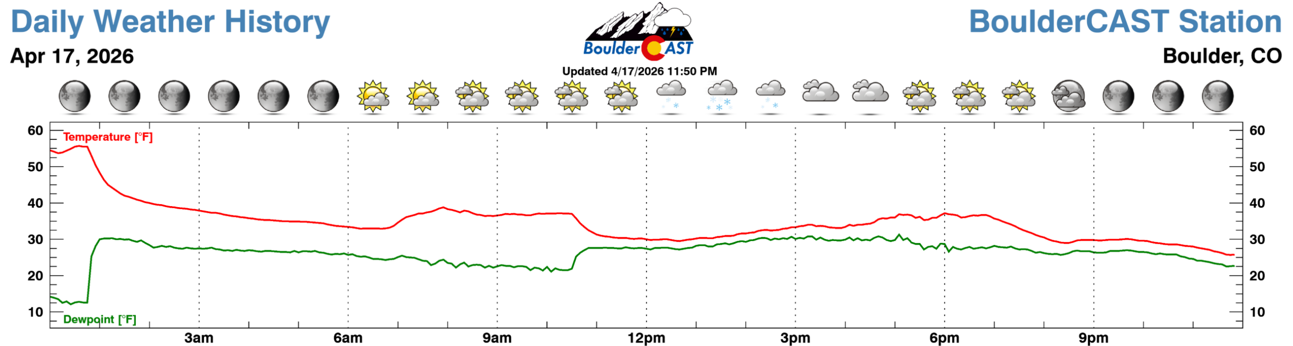
riday’s storm lived up to its reputation as a quick, compact spring system — one that arrived a tad late, hit hard, and cleared out almost as fast as it arrived. The Front Range woke up to a sharp temperature drop behind the overnight cold front.
And yes, the snow was a few hours behind schedule. But as we emphasized in our morning update, a delayed start was not about to equal a dud storm.
Snow finally pushed into most of the Denver–Boulder corridor between 10 and 11 AM Friday morning.
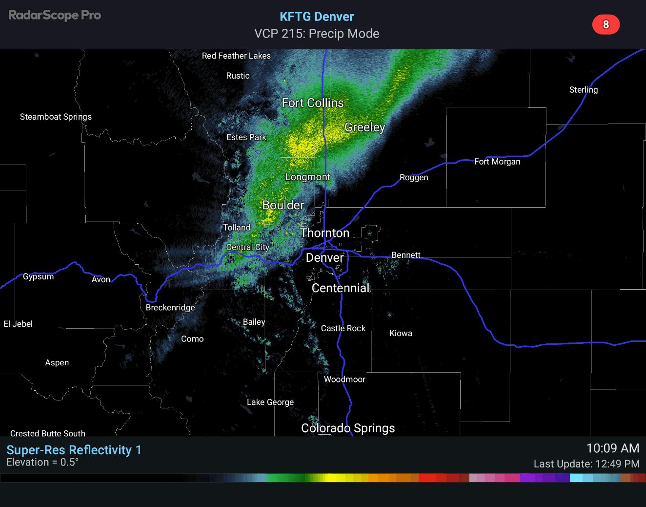
At first, flakes struggled thanks to a stubbornly dry surface layer. But once saturation was reached, the atmosphere went from zero to sixty fast — moderate to heavy, wet, gloppy snow erupted across much of the Metro area. Boulder’s drought‑browned landscape turned white almost instantly, a dramatic reminder of how quickly our weather can pivot:
That feisty initial burst was the whole show: a concentrated 3 to 5 hour window of steady snowfall that coated grassy surfaces and briefly slushed up roads in the higher terrain. The intensity was enough to drag temperatures below freezing during the early afternoon — remarkable considering we were basking in the mid–upper 70s just 24 hours earlier.
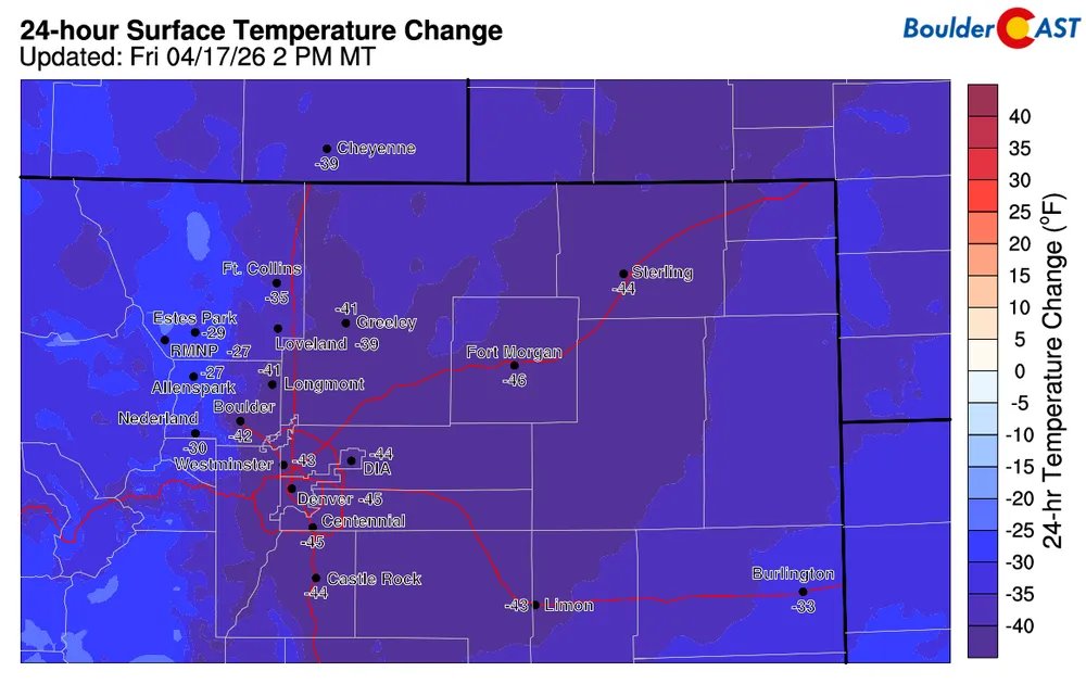
40 to 45° colder Friday afternoon than it was Thursday afternoon!
By late afternoon, northwest downslope winds surged in, drying out the atmosphere and shutting down lingering flakes. Sunshine even broke through before sunset, bookending the midday winter blast with brighter skies.
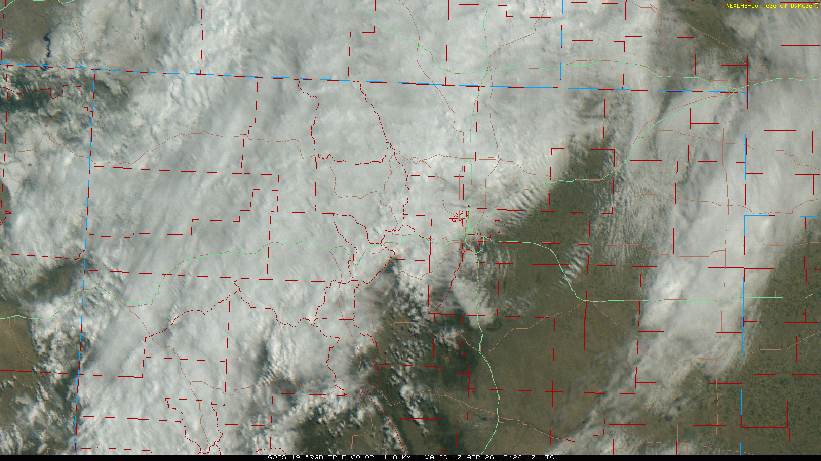
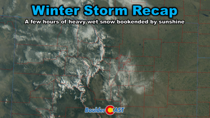
Visible satellite animation from Friday as snow bands pounded the area. Note the quick drying that floods in behind the snow from the northwest.
Friday ended up being a quintessential Colorado day — spring in the morning, winter at lunch, and spring again by dinner — and in many neighborhoods the snow was already mostly melted before the sun dipped behind the Foothills in the evening.
The snowfall totals
Our snowfall forecast map issued early Friday morning is shown below with storm totals overlaid. Green values indicate our forecast verified, Yellow values mean the observed total was just outside our forecast, while Red was a busted forecast (more than 1″ off).
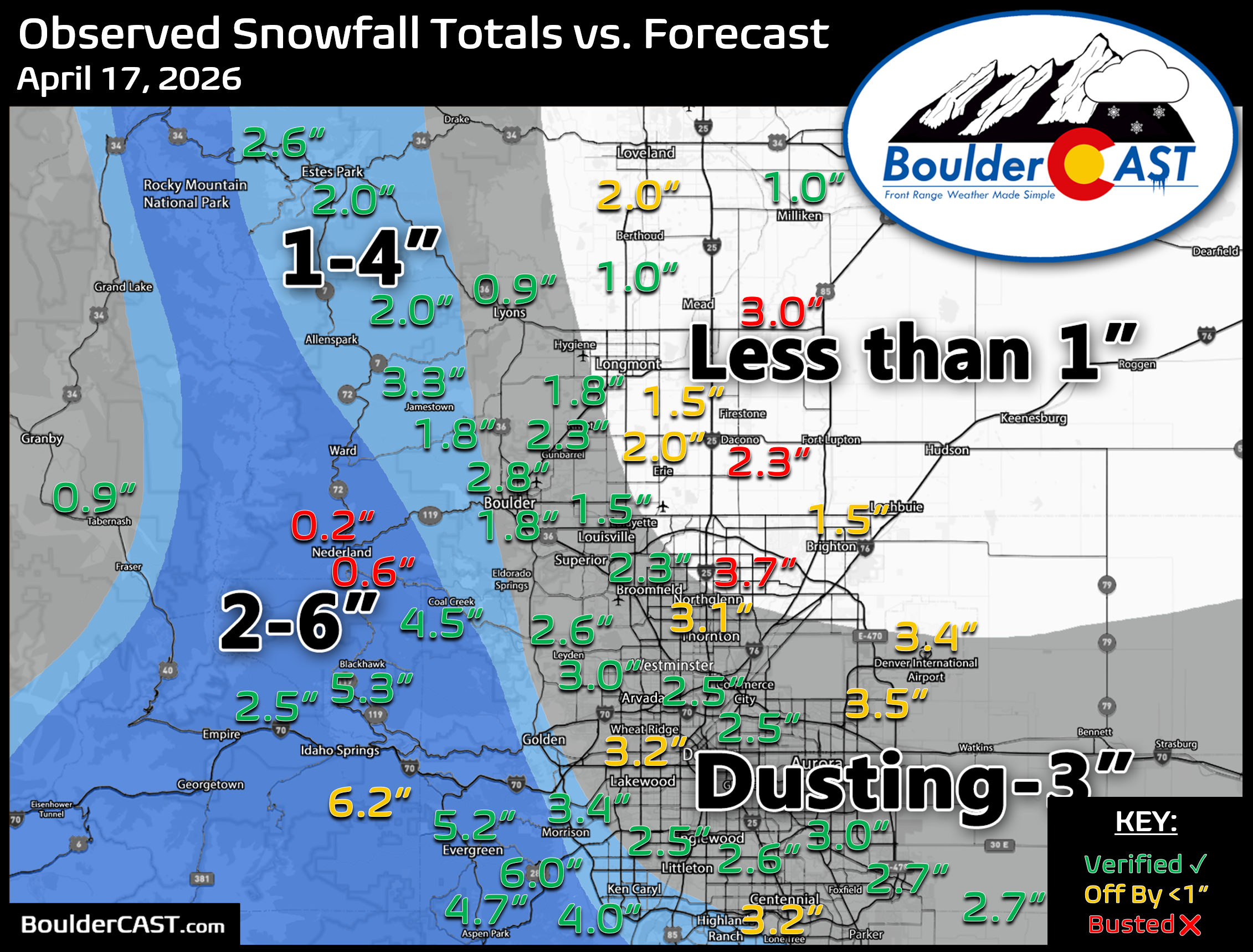
Warm ground temperatures and April sun kept totals in check. Most lower‑elevation spots stayed under 3 inches, and the Foothills came in under 6 inches. Overall, the forecast was… fine. We correctly highlighted the Jefferson County Foothills as the likely hotspot, but we missed on the idea that areas north and northeast of Denver/Boulder would see noticeably less snow. In reality, the snow bands didn’t discriminate much — nearly everyone saw several hours of heavy snow and at least an inch or two of accumulation.
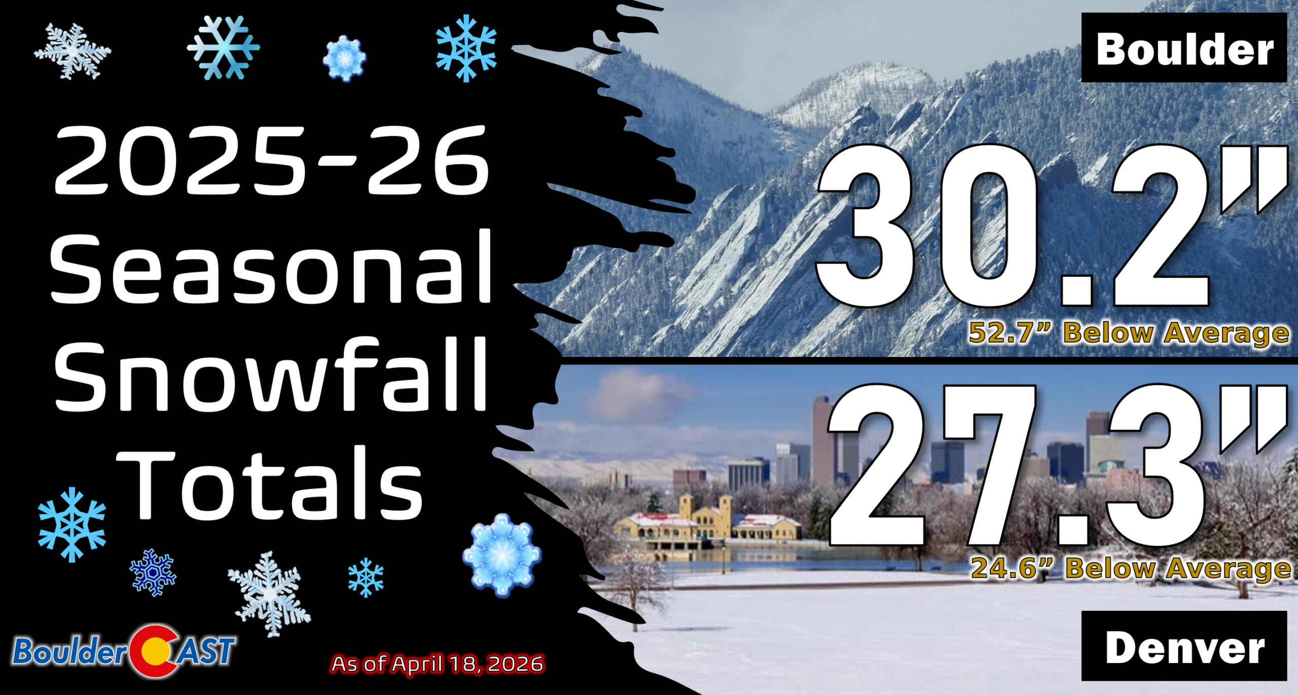
Despite this storm’s best efforts, both Boulder and Denver remain well below normal for the season.
- Boulder at 30.2″ (36% of normal)
- Denver at 21.9″ (53% of normal)
You can find a recap of all the winter storms so far in the 2025-2026 snow season HERE.
The window for additional accumulating snow is beginning to close rapidly in the coming weeks. Yes, it often snows here in May, but usually not that much.

Moisture: Okay but still light
Liquid totals were far from impressive and aligned closely with what the models were broadly predicting:
- 0.02″ to 0.40″ across most of the Front Range
- Highest amounts: In Jefferson County Foothills, and parts of Boulder proper
- Lowest amounts: In parts of the higher Foothills, areas far northeast and east
This was a small shot moisture in the grand scheme of things, but it should tamp down fire concerns—at least temporarily.
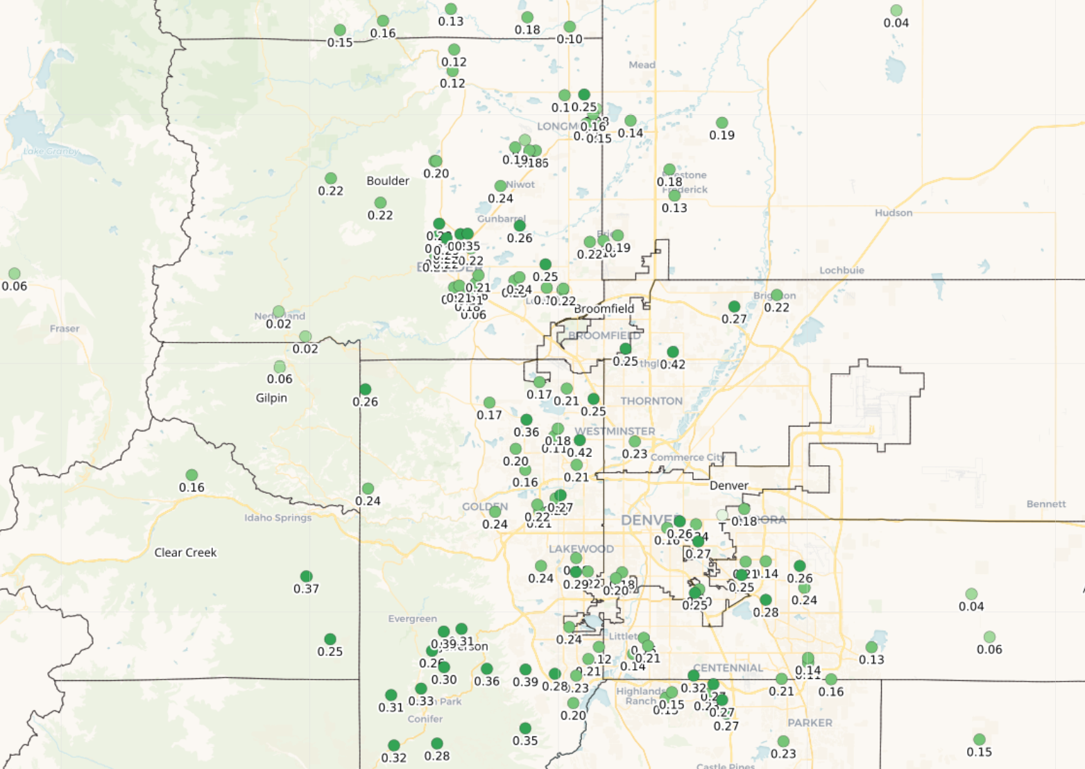
Front Range precipitation totals from the storm (April 17 2026)
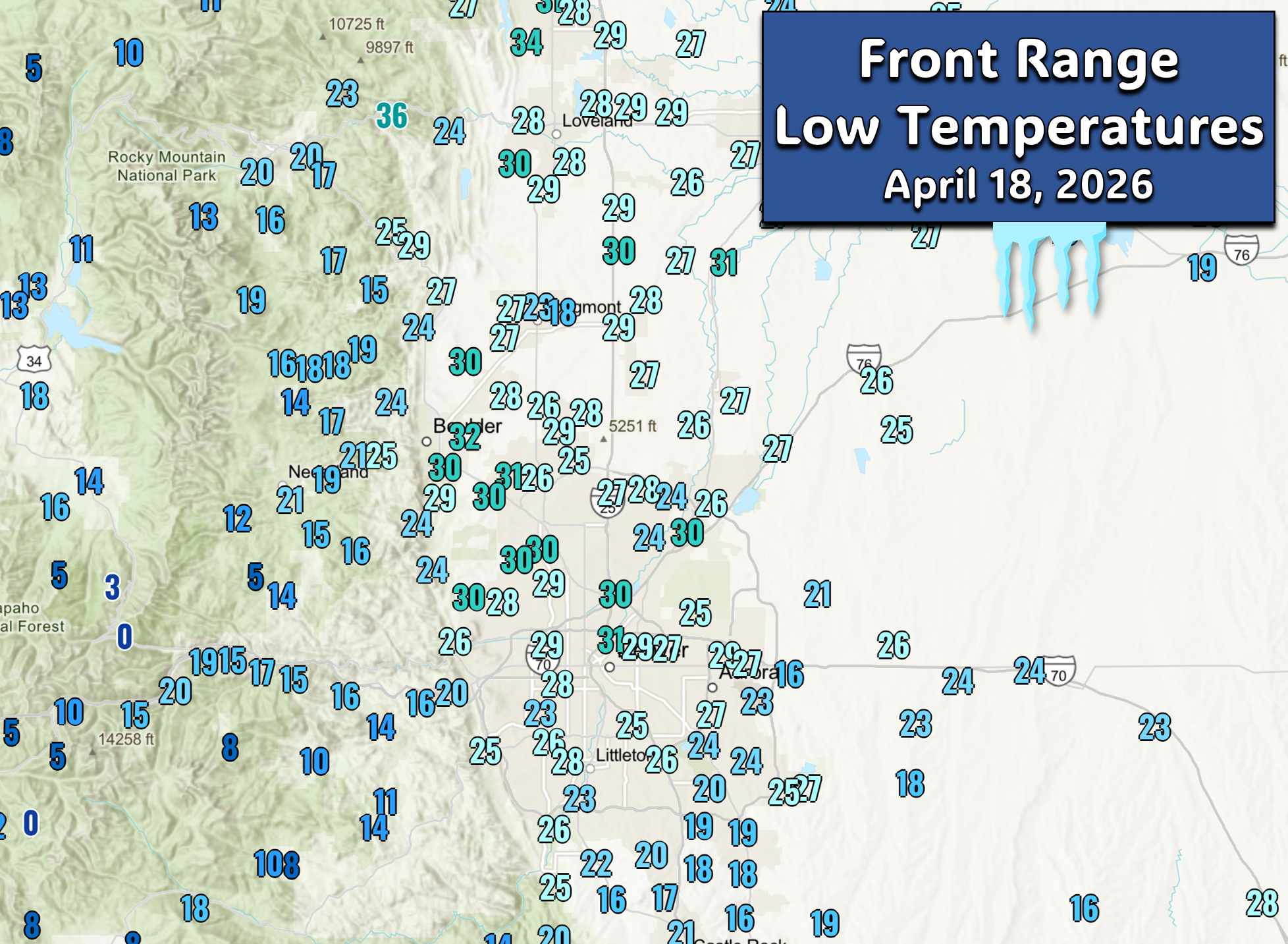
The hard freeze that wasn’t that hard
The rapid clearing Friday evening set the stage for what could have been a damaging, widespread hard freeze for a region where plants have already leafed out thanks to our record‑warm winter and early spring. However, as the snow tapered, models began trending toward a less severe overnight drop — something we pushed out in a Friday evening update.
Overnight lows ended up staying above 26° for much of Denver, and even Boulder dodged a true hard freeze, holding above 30° for the most part. A close call, but not the true vegetation‑shocker it could have been had we plummeted 5° colder like initial forecasts. These type of temperatures that occurred Friday night can easily happen in early to mid May during normal years, so most plants should be just fine. The pretty blooming plants may loose a bit of their luster, though.
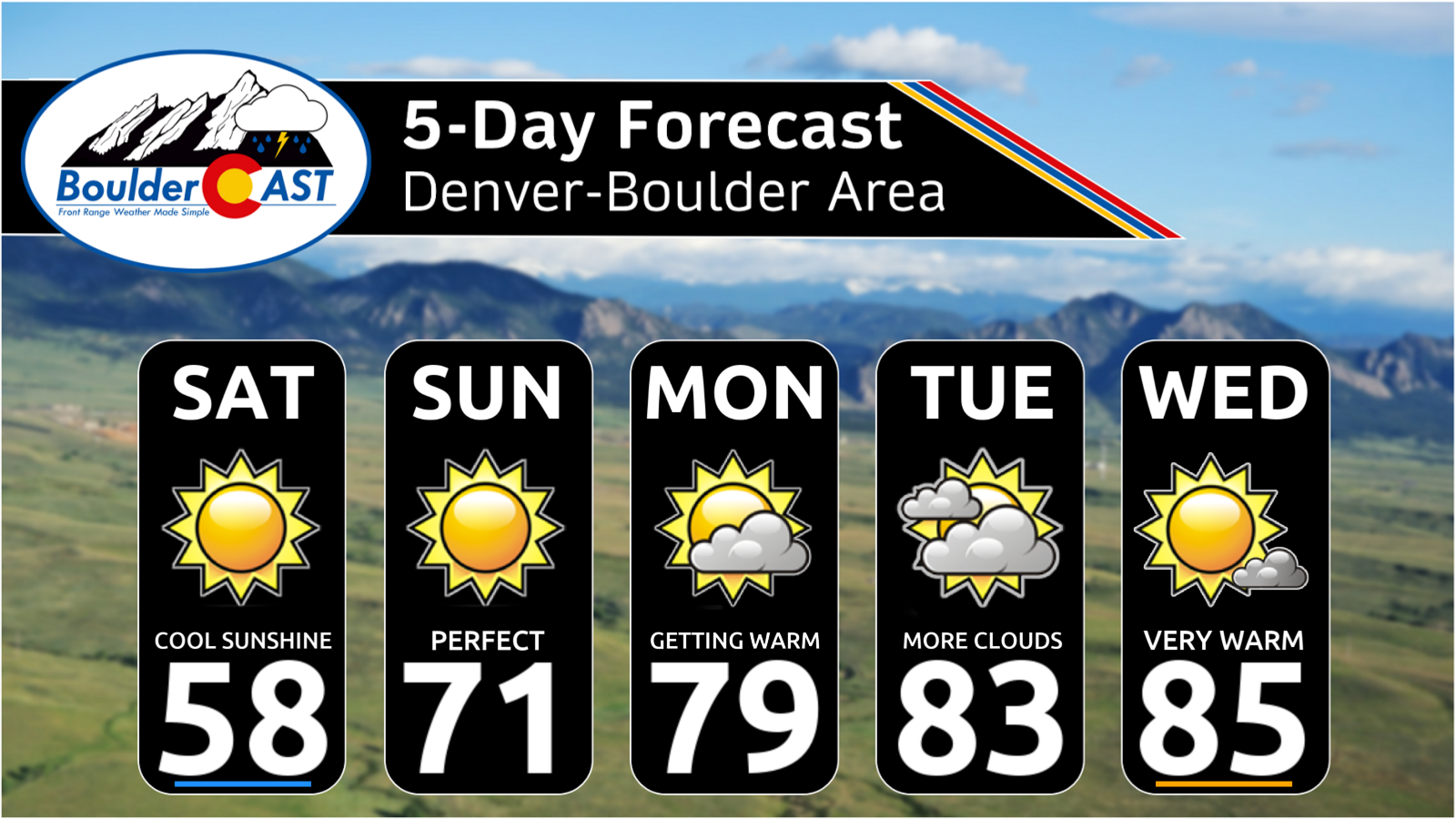
Looking ahead: More warm, more dry
Now we shift into a classic Colorado spring rebound: cool sunshine is on tap for Saturday, then a sharp warm‑up into the lower 70s by Sunday with 80s lining up next week.
Friday’s storm was helpful, but it didn’t change the trajectory. Unless we see a meaningful pattern shift in late April or May — something that delivers widespread, soaking precipitation rather than brief, fast‑moving bursts of light rain or snow — we’re still staring down a summer that will be hotter, smokier, and more water‑restricted than what most of us would like to imagine. The moisture deficit is simply too large for one spring storm to erase.
Spread the word, share our crazy Colorado weather:

Go Premium, get all the perks.
Daily Forecast Updates
Get our daily forecast discussion every morning delivered to your inbox.
All Our Model Data
Access to all our Colorado-centric high-resolution weather model graphics. Seriously — every one!
Ski & Hiking Forecasts
6-day forecasts for all the Colorado ski resorts, plus more than 120 hiking trails, including every 14er.
Smoke Forecasts
Wildfire smoke concentration predictions up to 72 hours into the future.
Exclusive Content
Weekend outlooks every Thursday, bonus storm updates, historical data and much more!
No Advertisements
Enjoy ad-free viewing on the entire site.


You must be logged in to post a comment.